Archaeology of the World Trade Center post-9/11

The history of the World Trade Center (WTC) is not ancient; 21 years ago, the building was under an attack coordinated by a terrorist group known as Al-Qaeda. This incident snatched thousands of lives and left many injured, and the trauma still pervades numerous lives. It is now memorialized as 9/11 to remember the victims of this unexpected attack and to support the families who lost their loved ones. 

The archaeology of the WTC post-9/11 was never about finding and displaying the remains and artifacts found, but in fact it is more profound than that. It is about finding the story of the individuals who lost their lives. It is about the shared emotions that emphasize and evoke our connection to daily life. Many artifacts collected were exhibited at the Smithsonian in 2004, which included a wallet, a computer screen, a stairwell sign, and a resume (Shanks 2004). One such case is of the resume found in a briefcase by an EMT on ground zero who tracked down the owner, and upon sharing their testimonies about the normal morning they had before 9/11, they realized their normal lives had changed to a rather traumatic one with the blink of an eye (Shanks 2004). Hence, these artifacts depict a story of an individual’s daily life and are preserved for future generations to see and learn the history of people who lost their lives, people who were tracked down later for their belongings, and of those who came out to rescue. 

Since the collapse of the two buildings, tons of debris collected around it and was dumped in the Fresh Kills Landfill in Staten Island, and archaeologists and forensic investigators later sifted through the landfill to find numerous artifacts and human remains (Atimian 2011). In the scenario of 9/11, it was unusual because the debris from the collapse contained tons of artifacts that became a source of knowing the victims intimately. It started to seem like the City of Pompeii, another mass casualty incident, even though the destruction occurred due to completely different reasons. But it held archaeological significance and the pieces of artifacts unlocked bigger pictures and understandings of those immediately affected by the incident. 

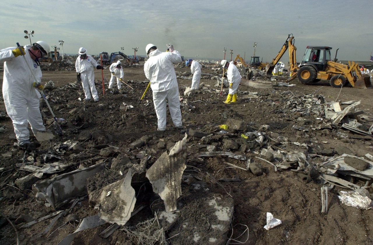
Image 1. Investigators sift through the World trade Center debris on September 18, 2001

Anything that happens in the present becomes the archaeology of the future and hence this disheartening incident did too. 9/11 entailed an archaeology lost and an archaeology found. The World Trade Center is not just home to the many artifacts of archaeological significance but also to the emotions, connections, and personal stories. It’s like a patchwork quilt made of stories that were carved from the remains, the stories that we might never have known and the individuals who those stories belonged to.

Image 2. The remains of the World Trade Center standing amid the debris on September 11, 2001.

References

Shanks, Michael, David Platt, and William L. Rathje. 2004. “The Perfume of Garbage:     Modernity and Archaeological.” John Hopkins University Press. https://muse.jhu.edu/article/53097

Strochlic, Nina. 2021. “The Archaeological Treasures That Survived 9/11.” History. National Geographic. September 2, 2021. https://www.nationalgeographic.com/history/article/the-archaeological-treasures-that-survived-911

Mayorquin, Orlando. 2022. “21 Years Later, These Powerful Photos Tell the Story of 9/11.” USA Today. Gannett Satellite Information Network. September 11, 2022. https://www.usatoday.com/story/news/nation/2022/09/11/911-photos-nyc-pentagon-shanksville/8036782001/

Atimian. 2011. “Fresh Kills Landfill.” Atlas Obscura. Atlas Obscura. December 30, 2011. https://www.atlasobscura.com/places/fresh-kills-landfill

Further Readings

https://nleomf.org/9-11-2001-artifacts-at-the-museum/

https://www.npr.org/2022/09/11/1122247528/us-marks-21st-anniversary-of-9-11-terror-attacks

https://www.pewresearch.org/politics/2021/09/02/two-decades-later-the-enduring-legacy-of-9-11/


Amino Acid Racemization – An Underutilized Relative Dating Technique

There are many types of dating in archaeology, including dendrochronology, radiocarbon, and potassium-argon dating, but most only accurately measure back about 50,000 years. Amino acid dating, also known as amino acid racemization, is a dating technique capable of measuring backwards up to three million years. It works by extracting proteins from a deceased organism and separating them into categories of amino acids. By measuring the exact ratio of two different amino acids, archaeologists can create an estimate of how long ago the specimen died, an example of which can be seen in Figure 1 (Demarchi 2020).  Although this dating technique is usually considered relative and most effective when used in comparison with other dated artifacts, it is also capable of being an absolute method.

https://www.antarcticglaciers.org/glacial-geology/dating-glacial-sediments-2/amino-acid-racemisation/

Figure 1. Fundamentals of amino acid geochronology. Chart by Dr. Beatrice Demarchi. https://www.antarcticglaciers.org/glacial-geology/dating-glacial-sediments-2/amino-acid-racemisation/

Unfortunately, despite its potential, amino acid dating is used more rarely in archaeology than expected. When it was first developed in the 1960s, various environmental aspects caused some fossils to lose their original protein, impacting early studies. After more time was spent studying amino acid dating, more reliable methods were produced, but the previous issues caused it to be pushed aside by many archaeologists. 

Luckily, amino acid dating is now becoming slightly more common. For example, University of York researcher, Kirsty Penkman, has been using amino acid racemization to date molluscs, egg shells, and corals, up to three million years old, as can be seen in Figure 2. Penkman is also currently working on a large project involving using amino acid dating to date hundreds of European sites.

Figure 2. Kirsty Penkman works with fossil shells for amino acid dating. Photo from NEaar lab at the University of York. https://www.world-archaeology.com/features/expanding-amino-acid-dating/

Unfortunately, amino acid racemization does present some difficulties. The enclosing matrix is a challenging variable, since it can impact the acids (Method 2016). Temperature is also heavily connected to the accuracy of amino acid dating. Faster reactions occur in the development of the amino acids when it is warmer, so more precise dates are produced. However, these dates go back a shorter period of time. Slower reactions occur when it is cooler, so the dates are less specific, but go back over a longer period of time (Marchini 2020). 

Although there can be some inconsistencies, overall, amino acid dating holds a lot of promise. It can provide insights to human behavior, such as the use of fire and burial practices (Johnson, and Miller 2007). It can be used to date a variety of artifacts, including mollusks, ostrich eggshells, corals, and some sediments. Using the amino acid dating on sediments is invaluable when incorporated into stratigraphy. Amino acid racemization can even be used on tooth enamel, allowing archaeologists to date mammals, including human remains. And because it can cover a large period of time, it is incredibly valuable when looking at human, animal, and technological evolution.


Further Readings 

Identification of Remanie Fossils Using Amino Acid Racemisation

Relative and Absolute Dating of Quaternary Mollusks With Amino Acid Racemization: Evaluation, Applications and Questions

References

  Demarchi, Beatrice. “Amino Acid Racemisation.” AntarcticGlaciers.Org (blog), June 22, 2020. https://www.antarcticglaciers.org/glacial-geology/dating-glacial-sediments-2/amino-acid-racemisation/.

  Johnson, B. J., and G. H. Miller. “ARCHAEOLOGICAL APPLICATIONS OF AMINO ACID RACEMIZATION.” Archaeometry 39, no. 2 (September 7, 2007): 265–87. https://doi.org/10.1111/j.1475-4754.1997.tb00806.x.

  Marchini, Lucia. “Expanding Amino Acid Dating.” World Archaeology (blog), May 27, 2020. https://www.world-archaeology.com/features/expanding-amino-acid-dating/.

  “Method – Amino Acid Geochronology Laboratory – Northern Arizona University,” October 2, 2016. https://web.archive.org/web/20161002171642/http://nau.edu/CEFNS/NatSci/SESES/AAGL/Method/.

Using Bead Archaeology to Discover Information about Regions of the World

Figure 1: a bead from the Neolithic Era

According to the Oxford Dictionary, “Typology is a classification according to general type.” Typology can range from the mapping of unknown gravestones in cemeteries to even objects themselves. Beads can be found in many different sections of the world from all different time periods dating back to 3800 BC. In looking at the physicality of a bead, archaeologists gain a deeper understanding of the technology used to produce the bead as well as the time period that the bead was crafted in. By mapping different types of beads by date, material, and shape, archaeologists are able to determine the types of societies in a specific region and the technology that they had access to/developed. 

Horace Beck was one of the first archaeologists to attempt a study of beads in 1928. He categorized different materials and sizes of beads, which led to an increased interest in the archaeological study of beads . Before Beck, beads were often viewed as smaller objects and their meaning was largely unknown. They were often lost due to insufficient recovery techniques.

In a study done 30 years ago in the Levant, Daniella E Bar-Yosef Mayer studied beads and categorized them by shape, region, age, and material. She visited twenty-two archaeological sites in an effort to work towards a typology of beads from in and around the Neolithic Period. The conclusions drawn from this study include findings such as how characteristics of the beads display aspects of chronology within societies, how societies can be dated due to the type of bead, and how certain groups were trading their resources with other groups. She is continuing to work on her typology of beads today in different areas of the world.

Figure 2: the beginning of a typology of Neolithic beads in the Levant

The beads found throughout the Levant display a wide range of time periods. As time periods changed, so did the type of beads and the technological features that were used to create them. Bar-Yosef Mayer writes in PLos journal, “We conclude that between 160 ka BP and 140 ka BP there was a shift from collecting complete valves to perforated shells” (Bar-Yosef Mayer 2022). Not only does this mean that new technology was being developed, but also, people were developing new ways to display and exchange beads. As soon as perforated shells were introduced, the beads could now be worn on a string. The transition from carrying beads to a form of human adornment with “jewelry” shows a change in time period and another way for beads to move larger distances.  

As more typologies of beads are created, more information about the connections of certain societies can be drawn. For instance, if one bead is found in one region but the same bead is found 100 miles away, it can be inferred that those societies are interconnected. The mapping of beads on different archaeological sites throughout the world has led to a better understanding of the connections between groups of people throughout the world, human necessity for self adornment, and the understanding of past behavioral patterns.

References 

Beck, Horace

1928  Classification and Nomenclature of Beads and Pendants. Journal

Archaeologia(77):(1-17)

E. Bar-Yosef Mayer, Daniella

  February 24, 2014  Towards a Typology of Stone Beads in the Neolithic Levant.

    Journal of Field Archaeology(2):129-142

E. Bar-Yosef Mayer, Daniella

  2017  In Not Just for Show, edited by Daniella Bar- Yosef Mayer, pp. 69-81. Oxbow

    Books, Oxford.

E. Bar-Yosef Mayer, Daniella

  July 8, 2020  On Holes and String. PLoS ONE journal 15(7):abstract


Extra Image References

https://www.ancientbead.com/neolithic_beads.html

https://www.researchgate.net/figure/Map-of-bead-color-by-feature-context_fig9_292708642


Additional Content/Readings

https://pubmed.ncbi.nlm.nih.gov/32640002/

https://www.researchgate.net/publication/292708642_Revising_the_Community_Plan_of_the_ell_Site_47_WN_009_Processes_and_Outcomes_of_GIS_Spatial_Analysis#pf18

Bodies in the Bog: Revealing Early European Rituals

The lands of northern Europe are peppered with muddy bogs full of decaying life. On the surface, these wetlands seem like nothing more than pools of moss and disease, but underneath lies a real treasure: bog bodies. These bodies have been exceptionally well preserved by this unlikely environment, even down to their last meal. 

A look at the layers of a peat bog. A body can be trapped and preserved for thousands of years.

So how does this phenomenon occur? The secret to their remarkable preservation is a specific moss called sphagnum. The moss itself creates an insulated dome that prevents most oxygen from filtering through to the land beneath it. Not only that, it acts as a sponge that absorbs calcium and magnesium from its surroundings, resulting in a more acidic environment that is toxic to natural decomposers like bacteria and fungi. Even in death, the moss acts to preserve the bodies by releasing a chemical called Sphagnan that both eliminates bacteria and gives these bog bodies their signature leathery brown/black skin.

These bodies tell tales that bring up a lot of questions for the archaeologists that discover them. Primarily, most of the bodies have telltale marks of violent death, whether through hanging, stabbings, or blunt force trauma. On occasion, the bodies even show multiple fatal wounds, baffling researchers further.

The mummified head of the aforementioned Lindow Man. A notch can be seen where a blunt object fractured his skull.

One of the more significant bodies in this puzzle is the Lindow Man. Discovered by peat cutters in 1984, this corpse was found to be a young man who lived around the 1st century A.D. Researchers identified three different causes of death: he was hit in the head, garroted, then had his throat slit. The discovery of water in his lungs also indicates this wasn’t simply somewhere his body was dumped. He was intentionally killed far out into the bog, though the exact reason for this is unknown.

Some have speculated that these bodies may have been a result of some kind of violent ritual based on cultural beliefs surrounding the bogs. While we may not see bogs are particularly useful today, in the Iron Age, bogs were a vital part of their society. Some professionals theorize that these societies may have believed that the bogs had some connection to the underworld or a higher power, and that ritual death would often occur in bogs as a result. The details of Lindow Man’s last meal (a charred griddle cake) lend credence to this theory as well. An old British ritual has people pull griddlecakes from a bag, with the one that pulled the charred cake put to death. 

As Europe closes down its bogs due to peat harvesting’s adverse effect on climate change, there will certainly be fewer bog bodies to be discovered and investigated. The mystery of the bog bodies might just remain a mystery for a little longer.

Links of Interest

Video Documentary of North American Bog Bodies

Specifics About Lindow Man

References

Magazine, Smithsonian. “Europe’s Famed Bog Bodies Are Starting to Reveal Their Secrets.” Smithsonian.com, Smithsonian Institution, 1 May 2017, www.smithsonianmag.com/science-nature/europe-bog-bodies-reveal-secrets-180962770/.

Mancini, Mark. “Peat Bogs Are Freakishly Good at Preserving Human Remains.” HowStuffWorks Science, HowStuffWorks, 24 Aug. 2022, science.howstuffworks.com/environmental/earth/archaeology/peat-bogs-are-freakishly-good-at-preserving-human-remains.htm.

“The Mystery of the Human Sacrifices Buried in Europe’s Bogs.” BBC Future, BBC, www.bbc.com/future/article/20220907-the-mystery-of-the-human-sacrifices-buried-in-europes-bogs.

Experimental archaeology and its uses

Figure 1: Metal working in the Museo Archeologico Etnologico in Modena. Photo by Andrea Moretti. https://exarc.net/issue-2019-1/ea/experimental-archaeology-who-does-it-what-use

            Experimental archaeology is defined as a sub-field of archaeology research that uses many strategies to imitate past events and attempt to better understand what happened (Paardekooper 2019). While experimental archaeology does have its limits in not working with real artifacts, it does have the unique advantage of attempting to repeat the processes that occurred in the past and gain knowledge through data and experience.

            Traditionally, this sub-field was one of the aspects of archaeology that is conducted scientifically by developing a hypothesis, conducting an experiment, and then analyzing the data to come to a conclusion. However, experimental archaeology has grown and taken on many forms now, such as being used as an outreach program. For example, researchers at the Stonehenge Visitor Center replicated a possible version of the creation of Stonehenge using wooden logs, ropes, simple mechanics, and community participation (Archaeology 2018) (Figure 2). Through this experiment, more questions about the creation of Stonehenge were developed, such as what were the environmental conditions when it was built? Researchers speculated that it could have been done when the ground was dry and hard, or the people may have dug the topsoil off to reach the hard and compact dirt. These hands-on experiences help inform the public of the importance of archaeology, while also bringing forth new research questions.

Figure 2: Imitating possible strategy for moving stones at Stonehenge Visitor Center. Photo by the English Heritage. https://the-past.com/feature/experimental-archaeology-at-stonehenge/

            Another example of experimental archaeology is the Butser Ancient Farm. The goal of this site is to study the agricultural and economic aspects of England during the period of 400 BC to 400 AD (Stone and Planel 1999). To better understand this topic, specific research programs cover different topics, such as experimental earthwork. Experimental earthwork is the study of replicating structures made from soil such as ditches, banks, and canals (Shaw 2007). In this specific study, a set of ditches and banks were recreated to see how they were effected by environmental conditions over intervals of four, seven, and ten years (Shaw 2007). Through this type of study, researchers can further understand how different layers of soil erode and settle over time. This allows them to identify what they are observing at a genuine site. Another benefit when modeling earthworks is understanding how artifacts are preserved in certain soil conditions. Through this work, archaeologists can recognize how much time it takes for certain materials to degrade and how quickly they need to excavate certain sites to preserve artifacts.

            Experimental archaeology has evolved to take on different forms with each having an important purpose. From social outreach programs to scientific studies, experimental archaeology is allowing archaeologists to better understand what they find and show the public the importance of their work.

Links of interest

https://exarc.net/issue-2013-3/ea/living-conditions-and-indoor-air-quality-reconstructed-viking-house

https://www.universiteitleiden.nl/nexus1492/news/start-of-reconstruction-indigenous-village-in-st.-vincent


References

Archaeology, Current. 2018. “Like a Rolling Stone: Experimental Archaeology at

            Stonehenge | The Past.” The Past. June 29, 2018. https://the-

            past.com/feature/experimental-archaeology-at-stonehenge/.

Paardekooper, Roeland. 2019. “Experimental Archaeology: Who Does It, What Is the

            Use?” EXARC Journal, no. EXARC Journal Issue 2019/1 (February).

            https://exarc.net/issue-2019-1/ea/experimental-archaeology-who-does-it-

            what-use.

Shaw, Christine. 2007. “Site Publications.” Butser Ancient Farm Archive. 2007.

           http://www.butser.org.uk/sitepubs.html.

Stone, Edited Peter G, and Phillippe G Planel. 1999. “A Unique Research & Educational

            Establishment,” 10.

The Business of Garbology

Garbology, the study of trash, was created by archaeologist Bill Rathje in the 1970s. Garbology involves examining waste in order to discover patterns about human behavior. These patterns can also be an important business strategy. Companies study waste in order to determine how well their products are doing in comparison to their competitors. 

In the 1970s a popular UK yogurt brand, Ski, started to face major competition. In order to do market research and compare Ski’s sales to their competitors, a garbology study was conducted. The study was done by Audits of Great Britain, through a “dustbin audit.” This meant that households across the UK were paid to put their trash from certain products and brands in a separate trash can. The trash was then collected and cataloged, revealing how often certain products were being purchased. Ski and their competitors were all on the list of products to be separated. The study revealed Ski’s success over the competition. This was a crucial marketing strategy, as it revealed that Ski was outperforming other brands, and allowed for them to negotiate favorable shelf space with grocery stores and other retailers. 

Garbology is also used for corporate espionage. Companies have been involved in elaborate schemes to steal trash from their rivals, all in the hopes of gaining valuable intelligence on their products. One example of this is the 2001 conflict between hair-care companies Proctor & Gamble (P&G) and Unilever. P&G admitted to going through Unilever’s trash in hopes of gathering information. Senior P&G officials were supposedly unaware of the operation and put a stop to it after finding out. This involved handing documents over to Unilever, firing multiple employees involved, and issuing an official apology. This example is one of many where companies have been caught spying. In fact, there are those who have made their careers in the garbology side of corporate espionage. Marc Barry, co-author of Spooked: Corporate Espionage in America, claims to have searched over 2,500 dumpsters throughout his career, but that it is one of the riskiest forms of corporate espionage, because “If one of your agents gets caught, there’s no plausible deniability” (Sachdev 2001). While risky, many companies use garbology as an intelligence strategy because of how much information they can gain on their competitors’ products, making it a surefire way to get ahead. 

The numerous ways in which garbology can be applied to marketing and business strategy demonstrates how valuable of a tool it is. When studying trends of human behavior or advancements in products, trash is an important physical data point. As a business strategy it is a way of studying the market in order to get ahead. There are some ethical concerns with how these strategies may be conducted, and most of them are deemed unprofessional, as they are initiated by one company without the others’ consent. However, these strategies persist, as it is difficult to doubt their business-advancing results. 


Students sorting through trash to be cataloged

Example of a waste/dustbin audit

Further Reading:

History of Garbology:

https://www.starsinsider.com/lifestyle/501073/garbology-the-lessons-we-can-learn-from-peoples-trash?utm_source=rss-lifestyle&utm_medium=rss&utm_campaign=rssfeed 

Garbology and Our Future:

https://www.youtube.com/watch?v=m9qR2_67xaQ 

References

Baraniuk, Chris. 2022. “Garbology: How to spot patterns in people’s waste.” BBC. https://www.bbc.com/future/article/20220429-garbology-how-to-spot-patterns-in-peoples-waste.

Boisvin, Lindsey, and Karen Cheng. 2016. “Animated waste installation | UW Facilities Blog.” UW Facilities. https://facilities.uw.edu/blog/posts/2016/04/18/uw-garbology.

“Garbology – Meaning, Importance & Example.” 2020. MBA Skool. https://www.mbaskool.com/business-concepts/marketing-and-strategy-terms/17878-garbology.html#3.

Logue, Stephen. 2016. “History of Ski.”

Sachdev, Ameet. 2001. “P&G admits Unilever garbage search.” Chicago Tribune. https://www.chicagotribune.com/news/ct-xpm-2001-09-01-0109010181-story.html.

“Waste Audit – Getting Started – Reductioninmotion.com.” 2022. Reduction In Motion. https://reductioninmotion.com/waste-consulting/waste-audit/.


Ozette Site: The Whaling Village Rediscovered Under a Blanket of Mud

By: Aidan Wisherd

Preservation of artifacts can be in a plethora of forms. For the Ozette Site in the Pacific Northwest, mud encased the whaling village dating back to 1700 CE (Renfrew 2018, 58). The Makah tribe’s tremendous history was revealed around 1970 following a weather event in Washington that began to reveal artifacts from the nearly 2000 year old whaling village (Renfrew 2018, 58). Ozette displayed past environmental and natural events, along with a deep history of the people that lived on the land. 

Figure 1. Rocks surrounding the excavation site display carvings dating back to before the mudslide of the Ozette Site in 1700 CE (Sainsbury 2022)

Ozette brings to light many key archaeological lessons to take as the examination of further Indigenous sites continues. Washington State University had been examining archaeological sites near the Makah’s land since the 1940s, but their breakthrough 20 years later was incomparable (Washington State University 2022). Richard Daugherty, an archaeologist from Washington State at the heart of the excavation and examination of the site for 11 years, prioritized a close relationship with the Makah (Washington State University 2022). This was to ensure both respect and care were taken with preserving and eventually displaying the tribe’s history. The way the artifacts were preserved must also be viewed. Mud worked to encase the history of the whaling village with six cedar houses and tens of thousands of artifacts (Sainsbury 2022). Wet clay surrounded the pieces of the thriving whaling village and acted as a sealant, keeping out air and protecting the pieces from erosion.

Figure 2. Richard Daugherty carefully examines one of the most important artifacts recovered from Ozette, a wood carving of a Whale’s fin (Washington State University 2022)

Crucial to the excavation in Washington was the relationship with the Indigenous peoples of the land. The Makah assisted Daugherty with the cultural context of many pieces that the team could not initially understand (Knight 2015). The relationship between the team and tribe went both ways, with Daugherty and his team working to not only preserve history but to help the Makah find what they previously thought to be lost. From the outset, the tribe was determined to display their artifacts on their land for generations beyond them to see (Sainsbury 2022). In this vein, around 500 pieces are currently on display within a museum that remains on Makah land and serves the local community and those that choose to visit (Sainsbury 2022). 

From the excavation of the site and the initial discovery, Ozette teaches us about how archaeology can teach and preserve. Approaching the site in a way that serves the Makah is important for archaeologists to mirror. It must be understood that the work is community-focused, rather than for name recognition associated with a dig or discovery.


Some pieces to view for further discovery:

Ozette: The US’ lost 2,000-year-old village

Makah Museum: Ozette Archaeological Site

———————————————————————————————————

References

Knight, Alexa. 2015. “Discoveries at Ozette.” Northwest Coastal Native Americans. May 28, 2015. https://nwcoastindians.wordpress.com/2015/05/28/discoveries-at-ozette/. 

“Ozette: The US’ Lost 2,000-Year-Old Village.” 2022. CAS in the Media . Washington State University. June 15, 2022. https://cas.wsu.edu/news/2022/06/15/ozette-the-us-lost-2000-year-old-village/. 

Renfrew, Colin, and Paul Bahn. 2018. Archaeology Essentials: Theories, Methods, and Practice. Fourth edition. Thames & Hudson.

Sainsbury, Brendan. 2022. “Ozette: The US’ Lost 2,000-Year-Old Village.” BBC Travel. BBC. June 6, 2022. https://www.bbc.com/travel/article/20220605-ozette-the-us-lost-2000-year-old-village. 

How Satellite Imagery and Crowd-Sourcing Can Revolutionize Archaeology

In 2016, seasoned archaeologist Sarah Parcak stood and spoke at the annual TED Conference in Banff, Canada, announcing the fully-funded launch of the first-ever crowd-sourced archaeological program. Dr. Parcak’s vision for this project was to allow the masses to play a role in archaeological site survey and research, which would expedite the path to archaeological discovery and preserve cultural heritage for many.

Aiming to publicize archaeology by seeking the service of thousands of “citizen scientists,” Parcak hoped to fully revolutionize the modern field of archaeological study. This envisioned revolution would build a larger network of archaeological data, drawing public attention to the need for archaeological discovery, and prioritizing the preservation of archaeological sites from threats such as looting (GlobalXplorer 2019). But Parcak’s ambitious plan was not without a fundamental method for archaeological survey: aerial satellite imaging.

Using high-quality aerial imagery provided by DigitalGlobe, thousands of randomly selected satellite images would be uploaded onto the GlobalXplorer portal and made available for volunteer participants to analyze (GlobalXplorer 2018). Learning how to spot potential archaeological sites as well as signs of looting, these suitingly-named “Xplorers” would be trained in video courses provided by the GlobalXplorer team (Hersher 2017).

The participants would next be shown a series of 300-by-300-meter satellite image tiles that they could then identify as a potential archaeological site or looted site (see Figure 1) (GlobalXplorer 2018). As these pictures would be filtered through tens of thousands of trained volunteers, images with the most positive feedback would be marked for trained specialists, such as Sarah Parcak herself, to analyze and further investigate (GlobalXplorer 2018). While the location of sites with confirmed looting activity could be forwarded to local government authorities, GlobalXplorer’s team of archaeologists could determine whether a potential site was ready for physical survey and documentation by partner local archaeologists (GlobalXplorer 2018). With as much manpower as it exhibits, GlobalXplorer is able to fully map large portions of entire countries, as they did Peru by analyzing 14 million total individual tiles in preparation for their first expedition (GlobalXplorer 2018).

Figure 1. The GlobalXplorer platform showing the crowd-sourced site identification program. Photo by GlobalXplorer Platform.

In total, Xplorers from around the world helped locate over 19,000 sites of archaeological interest in Peru, of which roughly 40 high-interest sites were selected for a ground-truthing expedition carried out by local archaeological and geological experts (GlobalXplorer 2018). The captured data would then be turned over to Peruvian authorities to allow the sites to be registered under the protection of the state (GlobalXplorer 2018). During their expedition, on-ground experts recorded what they believed to be undocumented geoglyphs (see Figure 2) related to Peru’s renowned Nasca lines (GlobalXplorer 2018).

Figure 2. Drone Image of geoglyphs in Peru identified by GlobalXplorer’s crowd. Photo by Luis Jaime Castillo Butters.

The successes in Peru are merely a glimpse of what the archaeological world can achieve when pairing a wealth of geographical data provided by satellite imagery with masses of individuals who see the value in locating and protecting sites of archaeological and even cultural significance. With further development of these opportunities and global networks, archaeology can be improved to better protect the sites that hold importance throughout local communities as well as the world.

For more information on GlobalXplorer, or to get involved when GlobalXplorer plans its next expedition, visit:

https://medium.com/@globalxplorer

https://www.globalxplorer.org

References:

GlobalXplorer. “About the GlobalXplorer° Project.” GlobalXplorer. Last modified 2019. Accessed September 11, 2022. https://www.globalxplorer.org/about.

GlobalXplorer. “GlobalXplorer° Completes Its First Expedition: What the Crowd Found in Peru.” Medium. Last modified April 10, 2018. Accessed September 11, 2022. https://medium.com/@globalxplorer/globalxplorer-completes-its-first-expedition-what-the-crowd-found-in-peru-7897ed78ce05.

GlobalXplorer. “Welcome to GlobalXplorerº!” Medium. Last modified April 3, 2018. Accessed September 11, 2022. https://medium.com/@globalxplorer/welcome-to-globalxplorer-7bfb555260a1.

Hersher, Rebecca. “Space Archaeologist Wants Citizen Scientists To Identify Archaeological Looting.” NPR. Last modified January 31, 2017. Accessed September 11, 2022. https://www.npr.org/sections/thetwo-way/2017/01/31/512661370/space-archaeologist-wants-citizen-scientists-to-identify-archaeological-looting.

Google Earth and Its Role in Monitoring the Looting of Archaeological Sites

Advancements in satellite imagery like Google Earth revolutionized archaeology in terms of its user-friendly interface, accessibility, and monitoring capabilities in the face of the rising looting crisis. 

Prior to Google Earth’s release to the public, three-dimensional imaging was costly, inefficient, and convoluted. In 2005, Google Earth revolutionized imaging: it was free to download, interactive, and visualized the entire planet from a computer screen. Aerial, oblique, and horizontal viewing angles are available with the platform along with “placemarks” that save coordinate locations, making it an important resource to archaeologists for aerial surveying (Ur 2006, 35). While Google Earth does not replace existing resources, it has proven to be a useful tool in data collection for site looting. 

Over the past few decades, looting incidents have increased, especially in countries lacking the authoritative figures, resources, and policies to adequately protect archaeological sites (Tapete 2016, 42-43). Without data and scale surrounding looting, archaeologists struggle to advocate for public policy to protect against it because authorities can claim an overestimation of the issue’s severity, and even if a policy was instituted, there is little structure to track the efficacy of any policy made. One method of collecting necessary data to protect against looting is to utilize Google Earth’s affordable imaging system (Contreras 2010, 101). Google Earth can be used in longitudinal studies by collecting images over a period of time and monitoring looting patterns, therefore providing background and context to determine what factors contribute to looting (Contreras 2010, 104).

Research conducted with Google Earth images discovered that 515,351 square meters were looted across archaeological sites in Jordan (see Figure 1), exemplifying the role basic imaging contributes to the field (Contreras 2010, 110). In another case study completed in a site in Apamea, Syria – a site on the World Heritage at Risk list – images analyzed from Google Earth from 2012 and 2014 proved that approximately 38% and 45% of the site was looted, respectively (Tapete 2016, 44). The two case studies highlight the significance of Google Earth as an archaeological tool to examine and quantify looting, a crucial step toward preventing and managing the crisis (Figure 2). By creating a key as in Figure 2, new looting marks, repeated looting sites, and clusters can be identified over a longitudinal study, providing the pertinent data to better formulate policy and protection over sites.

Figure 1. A Google Earth image from 2004 of a site in Safi detailing looting marks. Clusters are denoted by the white lines (Contreras 2010, 112).

Figure 2. This key demonstrates the use of Google Earth images and other specialized technology to determine looting patterns and occurrences in Apamea, Syria (Tapete 2016, 55).

While Google Earth remains a viable option for aerial survey due to its accessibility, there are constraints to its practicality that cannot replace existing, specialized technology in the archaeological field. There are multiple factors contributing to Google Earth’s image viability: the region must be well-documented with high-resolution photos, atmospheric conditions must be clear, and dry and desert landscapes are preferred (Contreras 2010, 111). Since 2005, Google Earth has been a key development that has propelled aerial surveying techniques to quantify looting, but this data must be applied to better allocate resources and formulate policies to protect these culturally significant sites.   

For further information on Google Earth and archaeology:

“How Google Earth Has Revolutionized Archaeology” https://www.discovermagazine.com/the-sciences/how-google-earth-has-revolutionized-archaeology

“Looting at Apamea recorded via Google Earth” https://traffickingculture.org/data/data-google-earth/looting-at-apamea-recorded-via-google-earth/

References:

Contreras, Daniel A., and Neil Brodie. “The Utility of Publicly-Available Satellite Imagery for Investigating Looting of Archaeological Sites in Jordan.” Journal of Field Archaeology 35, no. 1 (March 2010): 101-14. Accessed September 8, 2022. https://doi.org/10.1179/009346910X12707320296838.

Renfrew, Colin, and Paul G. Bahn. Archaeology Essentials: Theories, Methods, Practice with 303 Illustrations. 4th ed. London: Thames & Hudson, 2018.

Tapete, Deodato, Francesca Cigna, and Daniel N.M. Donoghue. “‘Looting Marks’ in Space-borne SAR Imagery: Measuring Rates of Archaeological Looting in Apamea (Syria) with TerraSAR-X Staring Spotlight.” Remote Sensing of Environment 178 (June 2016): 42-58. Accessed September 8, 2022. https://doi.org/10.1016/j.rse.2016.02.055.

Ur, Jason. “Google Earth and Archaeology.” The SAA Archaeological Record 6, no. 3 (May 2006): 35-38. Accessed September 8, 2022. https://tinyurl.com/yczc232l.

Applying Lidar Technology in Archaeology of Pre-Hispanic Latin America

Lidar is a remote sensing technology that allows archaeologists to gain a better understanding of the geographical features in an area without surveying on the ground. It is utilized by pulsing lasers from a plane or drone down to the earth, and registering the time they take to return (US Department of Commerce, NOAA 2019). This data, combined with information from GPS, can generate an extremely accurate and precise topographic model of the area. It is especially useful because it is able to see through the treeline to the forest floor, which is vital in dense forested areas that would otherwise be difficult to ground survey or analyze through satellite imagery (Renfrew and Bahn 2018).

One region where the technology has been applied with great success is South and Central America. These regions have sections of extremely dense forest, as well as very little information recorded about pre-Hispanic societies, forcing archaeologists and historians to take different approaches to information gathering. While some societies, like the Inca and Maya, are the subject of a decent amount of recorded knowledge, in most other less established societies there is very little documentation. Lidar has proved to be extremely useful in discovering more about societal organization, agriculture, and infrastructure in lesser-studied parts of South and Central America. 


Figure 1. Map of lidar-analyzed site with outlines known and possible features picked up by lidar. Map created by Rivera-Collazo et al., 2021. 

Researchers have celebrated the role of lidar in the examination of thus far under-studied areas in Latin America. One group used lidar imaging to examine areas of Puerto Rico for ancient indigenous architecture. While there is limited lidar data for the Caribbean, open-access datasets revealed large-scale architectural planning, including plazas, paths, and possible agricultural areas. The authors discuss the helpfulness of lidar for this area in particular, which is densely forested and therefore difficult to access by ground survey or satellite imagery (Rivera-Collazo, Rodríguez-Delgado, and Rodríguez-Miranda 2021). This research reinforces the need for more lidar coverage in forested areas of the world, as it provides archaeological information that is not readily available in other forms. Another researcher discussed the use of lidar in the Bolivian Amazon, a region where researchers previously had known very little about pre-Hispanic societies. It was used to penetrate the treeline and two pre-hispanic low-density urban sites were discovered (Prümers et al. 2022). This type of society is harder for researchers to investigate because of a lack of written documents and permanent infrastructure, but the use of lidar can enhance search efforts. 

Figure 2. Topographical map created by lidar of the site Cotoca, a large settlement found in the Bolivian Amazon. Map created by Prümers et al. 2022. 

Many researchers in South and Central America support the use of lidar to discover more about Latin American pre-hispanic societies. The frequency of dense forests in these regions combined with the lack of comprehensive records of Indigenous societies and activities pre-colonialism makes it an excellent candidate for the use of lidar technology for initial archaeological survey. Lidar still requires corroboration, however, so it is not a replacement of fieldwork, but it can be used to narrow down sites for ground survey and excavation.

Works Cited

Prümers, Heiko, Carla Jaimes Betancourt, José Iriarte, Mark Robinson, and Martin Schaich. 2022. “Lidar Reveals Pre-Hispanic Low-Density Urbanism in the Bolivian Amazon.” Nature 606 (7913): 325–28. https://doi.org/10.1038/s41586-022-04780-4.

Renfrew, Colin, and Paul G Bahn. 2018. Archaeology Essentials : Theories, Methods, Practice with 303 Illustrations. London: Thames & Hudson Ltd.

Rivera-Collazo, Isabel, Eric Rodríguez-Delgado, and Marisol Rodríguez-Miranda. 2021. “Lidar Inspection for Indigenous Architecture at Caguana Ceremonial Complex, Borikén.” Latin American Antiquity 33 (1): 205–11. https://doi.org/10.1017/laq.2021.86.

US Department of Commerce, National Oceanic and Atmospheric Administration. 2019. “What Is LIDAR?” Noaa.gov. 2019. https://oceanservice.noaa.gov/facts/lidar.html.

Further Reading: 

Lost cities of the Amazon discovered from the air; https://www.smithsonianmag.com/science-nature/lost-cities-of-the-amazon-discovered-from-the-air-180980142/

Lidar reveals oldest and biggest Maya structure yet found; https://www.sciencenews.org/article/lidar-reveals-oldest-biggest-ancient-maya-structure-found-mexico