Community Efforts to Preserve the Presidio Pet Cemetery

In a small, unassuming plot of land in San Francisco’s Presidio, the Presidio Pet Cemetery is home to pets owned by military families since WWII (Gradwohl 2000, 22). The cemetery’s unkempt nature contrasts the pristine and orderly appearance of the nearby military veteran cemetery where the owners of these pets lie. Animals like dogs, cats, fish, rabbits, rats, hamsters, birds, and an iguana reside in the cemetery located under a highway overpass, portraying a conflicting message of what this obscure cemetery provides for the archaeological record (Gradwohl 2000, 22). As a San Francisco resident, the Presidio Pet Cemetery has always been an inconspicuous area made unappealing due to its inconvenient location under a highway overpass and its untidy appearance (Figure 1). However, beyond the aesthetics, the history of the cemetery is one of community perseverance and the recognition of animals and their effect on human history.

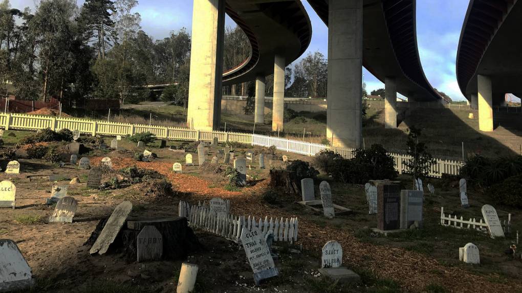
Figure 1. The Presidio Pet Cemetery in San Francisco, California. Photograph by Jasmine Garnett.

The Presidio Pet Cemetery demonstrates animals’ sociocultural significance in human history and provides a glimpse into the world of multispecies and post-humanist archaeology. Multispecies archaeology is the study of non-human species’ intricate lives and their impacts on human lives, politics, and culture; post-humanist archaeology is of a similar belief where non-human species are analyzed to study the past. By examining the cemetery through a multispecies and post-humanist view, the decorations and emotional epitaphs on the gravestones suggest these animals were loved and provided military families comfort in a tumultuous life. The most lavish graves, belonging to basset hounds Mr. Twister and Raspberry are a prime example as they are complete with large granite gravestones decorated with plants, artificial flowers, small basset hound figurines, mylar balloons, and heartwarming epitaphs (Gradwohl 2000, 24) (Figure 2). 

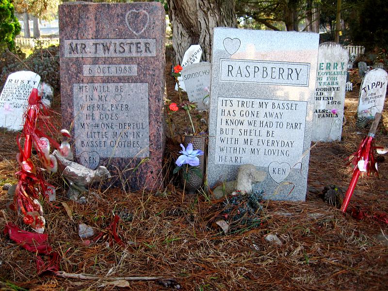
Figure 2. The ornate graves of basset hounds, Mr. Twister and Raspberry, in the Presidio Pet Cemetery. (Flickr 2008).

While the cemetery is intertwined with Presidio’s military history, it is considered a non-contributing feature in the Presidio of San Francisco Historic Landmark District (Kelly 2015). According to the Cultural Resource Management (CRM), a non-contributing site “does not add to the historic architectural qualities, historical or traditional cultural associations, or archaeological values for which a property is significant” (National Park Service 2002). While the pet cemetery lacks federal protection, the local community has overseen its preservation since its establishment in 1952. Groups like Boy Scouts of America, Swords Into Plowshares, and volunteers of the Presidio Trust have conserved the cemetery over the past 70 years even without the CRM’s protection (Kelly 2015). In 2011, the reconstruction of Doyle Drive (the highway overpass above the cemetery) threatened the cemetery’s destruction, but the construction management team labeled it as an environmentally sensitive area, and the community advocated for its protection as an emotionally sensitive area (Kelly 2015). Despite the lack of federal protection, public and community efforts work to immortalize the pet cemetery, exemplifying how present-day humans can decide what is historically significant – whether or not they are human. 

References:

Garnett, Jasmine. “Dedicated Neighbors Keep a Pet Cemetery and Presidio History, Alive.” KQED. Last modified February 29, 2020. Accessed October 25, 2022. https://www.kqed.org/arts/13875686/dedicated-neighbors-keep-a-pet-cemetery-and-presidio-history-alive.

Gradwohl, David Mayer. “Parakeet to Paradise.” Archaeology 53, no. 3 (2000): 22–24. http://www.jstor.org/stable/41779312.

Kelly, Bryan. “The Nine Lives of San Francisco’s Presidio Pet Cemetery.” Inversr. Last modified October 21, 2015. Accessed October 25, 2022. https://www.inverse.com/article/7246-the-nine-lives-of-san-francisco-s-presidio-pet-cemetery.

National Park Service U.S. Department of the Interior. “NPS-28: Cultural Resource Management Guideline.” National Park Service. Last modified August 2002. Accessed October 25, 2022. https://www.nps.gov/parkhistory/online_books/nps28/28appenq.htm.

SmugMug+Flickr. “Mr. Twister and Raspberry.” Flickr. Last modified August 21, 2008. Accessed October 25, 2022. https://www.flickr.com/photos/regency9/2803743974/.

Further Reading:

“Presidio pet cemetery protected”

https://www.sfgate.com/entertainment/article/Presidio-pet-cemetery-protected-3207974.php#taboola-1

“Dedicated Neighbors Keep a Pet Cemetery, and Presidio History, Alive” 

https://www.kqed.org/arts/13875686/dedicated-neighbors-keep-a-pet-cemetery-and-presidio-history-alive


Google Earth and Its Role in Monitoring the Looting of Archaeological Sites

Advancements in satellite imagery like Google Earth revolutionized archaeology in terms of its user-friendly interface, accessibility, and monitoring capabilities in the face of the rising looting crisis. 

Prior to Google Earth’s release to the public, three-dimensional imaging was costly, inefficient, and convoluted. In 2005, Google Earth revolutionized imaging: it was free to download, interactive, and visualized the entire planet from a computer screen. Aerial, oblique, and horizontal viewing angles are available with the platform along with “placemarks” that save coordinate locations, making it an important resource to archaeologists for aerial surveying (Ur 2006, 35). While Google Earth does not replace existing resources, it has proven to be a useful tool in data collection for site looting. 

Over the past few decades, looting incidents have increased, especially in countries lacking the authoritative figures, resources, and policies to adequately protect archaeological sites (Tapete 2016, 42-43). Without data and scale surrounding looting, archaeologists struggle to advocate for public policy to protect against it because authorities can claim an overestimation of the issue’s severity, and even if a policy was instituted, there is little structure to track the efficacy of any policy made. One method of collecting necessary data to protect against looting is to utilize Google Earth’s affordable imaging system (Contreras 2010, 101). Google Earth can be used in longitudinal studies by collecting images over a period of time and monitoring looting patterns, therefore providing background and context to determine what factors contribute to looting (Contreras 2010, 104).

Research conducted with Google Earth images discovered that 515,351 square meters were looted across archaeological sites in Jordan (see Figure 1), exemplifying the role basic imaging contributes to the field (Contreras 2010, 110). In another case study completed in a site in Apamea, Syria – a site on the World Heritage at Risk list – images analyzed from Google Earth from 2012 and 2014 proved that approximately 38% and 45% of the site was looted, respectively (Tapete 2016, 44). The two case studies highlight the significance of Google Earth as an archaeological tool to examine and quantify looting, a crucial step toward preventing and managing the crisis (Figure 2). By creating a key as in Figure 2, new looting marks, repeated looting sites, and clusters can be identified over a longitudinal study, providing the pertinent data to better formulate policy and protection over sites.

Figure 1. A Google Earth image from 2004 of a site in Safi detailing looting marks. Clusters are denoted by the white lines (Contreras 2010, 112).

Figure 2. This key demonstrates the use of Google Earth images and other specialized technology to determine looting patterns and occurrences in Apamea, Syria (Tapete 2016, 55).

While Google Earth remains a viable option for aerial survey due to its accessibility, there are constraints to its practicality that cannot replace existing, specialized technology in the archaeological field. There are multiple factors contributing to Google Earth’s image viability: the region must be well-documented with high-resolution photos, atmospheric conditions must be clear, and dry and desert landscapes are preferred (Contreras 2010, 111). Since 2005, Google Earth has been a key development that has propelled aerial surveying techniques to quantify looting, but this data must be applied to better allocate resources and formulate policies to protect these culturally significant sites.   

For further information on Google Earth and archaeology:

“How Google Earth Has Revolutionized Archaeology” https://www.discovermagazine.com/the-sciences/how-google-earth-has-revolutionized-archaeology

“Looting at Apamea recorded via Google Earth” https://traffickingculture.org/data/data-google-earth/looting-at-apamea-recorded-via-google-earth/

References:

Contreras, Daniel A., and Neil Brodie. “The Utility of Publicly-Available Satellite Imagery for Investigating Looting of Archaeological Sites in Jordan.” Journal of Field Archaeology 35, no. 1 (March 2010): 101-14. Accessed September 8, 2022. https://doi.org/10.1179/009346910X12707320296838.

Renfrew, Colin, and Paul G. Bahn. Archaeology Essentials: Theories, Methods, Practice with 303 Illustrations. 4th ed. London: Thames & Hudson, 2018.

Tapete, Deodato, Francesca Cigna, and Daniel N.M. Donoghue. “‘Looting Marks’ in Space-borne SAR Imagery: Measuring Rates of Archaeological Looting in Apamea (Syria) with TerraSAR-X Staring Spotlight.” Remote Sensing of Environment 178 (June 2016): 42-58. Accessed September 8, 2022. https://doi.org/10.1016/j.rse.2016.02.055.

Ur, Jason. “Google Earth and Archaeology.” The SAA Archaeological Record 6, no. 3 (May 2006): 35-38. Accessed September 8, 2022. https://tinyurl.com/yczc232l.