Mississippian-Era Jewelry: A Piece in the Puzzle of Pre-Columbian American Culture

Throughout history, jewelry and other decorative items have been unquestionably important symbols of culture, whether it be to showcase wealth, social status, or religious affiliation. For years, archaeologists have discovered jewelry dating back to the pre-Columbian era of North America, noting a few prominent materials: stone, shell, bone, and clay. Cahokia, as well as other Native American societies, commonly manufactured mass amounts of beads from such materials, giving archaeologists a glimpse into everyday productivity within pre-Columbian civilizations in North America. 

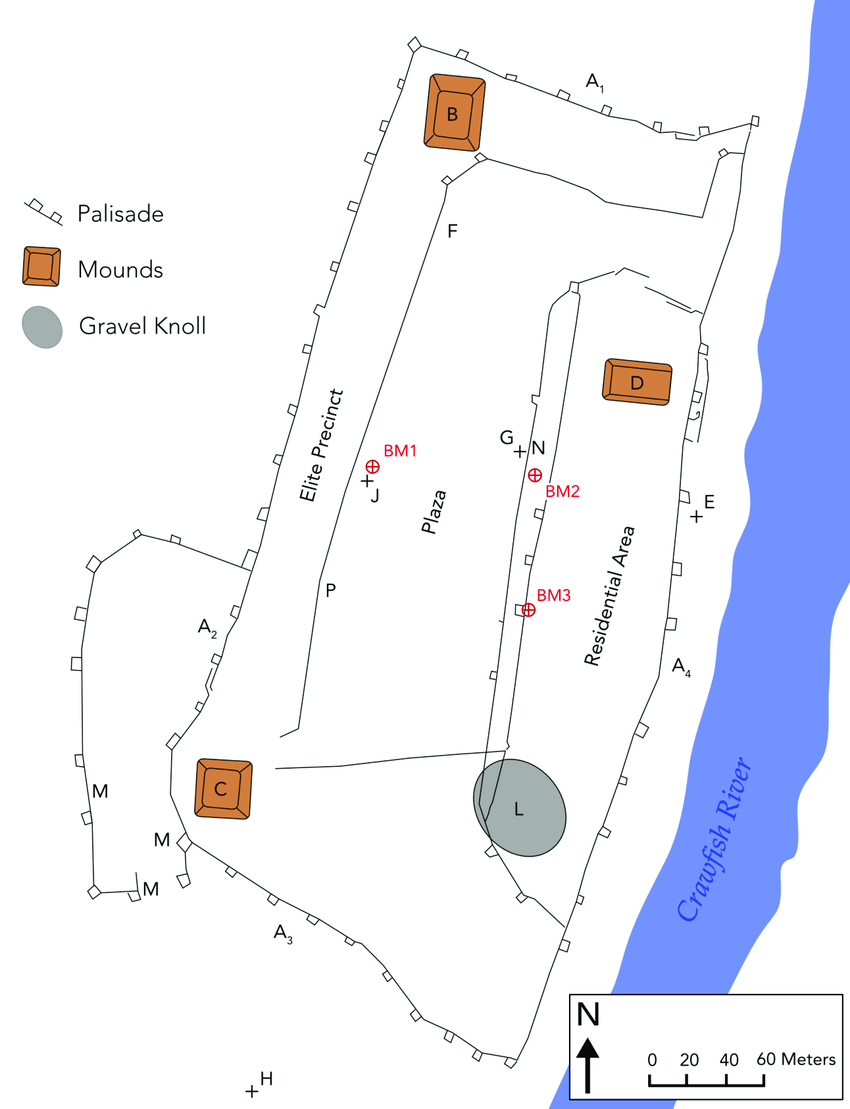
The city of Cahokia’s peak influence occurred roughly around 1100 AD, and it is characterized as the largest city Pre-columbian city in North America. Not only is it deemed so influential because of its sheer size, but largely due to its vast cultural outreach as well (Thomas and Perkins 2016). Upon the discovery and excavation of the Cahokian mounds, archaeologists discovered a number of burials, some of which were surrounded by thousands of shell beads (Figure 1). One bead material, in particular, lightning whelk shells, are thought to have symbolized many significant ideas in Cahokian culture. Due to their unique spiral shape, lightning whelk shells are thought to have symbolized the cycles of life and death, as well as served as a symbol of wealth, seeing as they were harder to obtain (Kozuch 2021). In addition to the symbolic importance of the shells, even their general quantitative discovery proved important to archeologists because it meant there was some form of a mass manufacturing system in Cahokia. While this argument is, for the most part, widely accepted, whether or not the beads were the result of specialized full-time labor or part-time domestic activities is still up for debate (Kozuch 2021). 

Figure 1: Marine shell beads discovered in the mounds of Cahokia. Retrieved from Illinois State Museum.

While Cahokian beaded jewelry mainly consisted of marine shell materials, others utilized stone and bone materials due to their more inland geography. Originally found in what is now Illinois, archaeologists discovered Mississippian-era stone beads, made from grinding and drilling rock with stone tools until the bead reaches its desired shape (Illinois State Museum 2000). Similarly to the manufacturing process of stone, necklaces made from hollowed bird bones were discovered at the Spiro Mounds located in Eastern Oklahoma. The specific necklace depicted below was a total of 34 inches in length and is estimated to be from between 900 A.D. and 1450 A.D. (Sanderson 2021). While many aspects of American culture have changed following the Mississippian Era, it is clear that the decorative and adorning qualities of jewelry have remained entirely relevant throughout society today.

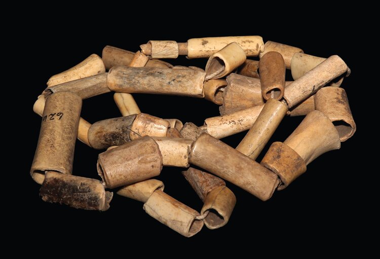
Figure 2: Necklace made from hollowed bird bone discovered at the Spiro Mounds in Eastern Oklahoma. Retrieved from Museum of Native American History.

Bibliography:

Kozuch, Laura. 2021. “Cahokia’s Mound 72 Shell Artifacts.” Southeastern Archaeology 40 (no.1): 33–47. https://doi.org/10.1080/0734578x.2021.1873057. Accessed 21 November 2022.

“Mississippian Economy Clothing.” Illinois State Museum, 2000. https://www.museum.state.il.us/muslink/nat_amer/pre/htmls/m_clothing.html. 

Sanderson, Jazlyn. 28 January 2021. “Spiro Mounds Bone Bead Necklace.” Museum of Native American History. https://www.monah.org/artifact-blog/2020/10/31/spiro-mounds-bone-bead-necklace. Accessed 21 November 2022.

Thomas, Jonathan, and Tyler Perkins. 19 April 2016. “Shell Bead Production at Cahokia.” the Digital Archaeological Record  https://core.tdar.org/document/404597/shell-bead-production-at-cahokia. Accessed 21 November 2022.

Additional Resources: 

  1. https://www.researchgate.net/publication/277638682_Shell_Symbolism_in_Pre-Columbian_North_America 
  2. https://www.academia.edu/24646883/Bead_Production_and_Cultural_Complexity_at_Cahokia 
  3. https://www.academia.edu/84217720/Crafting_shell_beads_at_East_St_Louis_and_Greater_Cahokia 

The Archaeology of Music


Music has been a staple within many cultures from across the world. We see it in traditions and all different forms of media. But where did it all begin? Archaeologists have failed to find any evidence indicating that musical instruments had been around 40,000 years ago. But this may be due to organic materials like bone and wood decaying and breaking down over time. We can also take into account that singing and clapping can not be traced by physical means. 

There is popular debate about the artifact that holds the title of “oldest musical instrument”. Originally back in 1995, archaeologists had discord the bone of a young cave bear with holes carved into it. Speculation led them to believe that this had previously been used as a flute. However, after further research some believe that the holes may not have been man made but created by hyenas’ teeth from scavenging the bear’s remains. 

Artifact that was once thought to be a flute.

Another musical instrument found is a beautiful lyre found in 1957 at the Eastern cemetery of Ambracia which dates back to the Hellenistic period. According to Greek mythology, it was invented by Hermes. When Apollo discovered that Hermes had stolen his oxen he prosecuted him. While Hermes was running to hide he stepped on a turtle shell. He noticed that the shell amplifies sound, so he created the first ever lyre and gifted it to Apollo to appease him. 

A music lyre from Ambracia.

Music and instruments can be found all over the world and throughout history. It is a form of human expression and can be used to communicate and even improve social relationships. Music is one of the few forms of communication that can transcend language. It has greatly developed over the years and has become one of the most enjoyed art forms.

References:

https://projectarchaeology.org/2021/10/07/music-in-archaeology-earliest-instruments/ 

A music lyre from Ambracia


Further Exploration:

http://www.emaproject.eu/

http://www.emaproject.eu/

Tracing the Vine; Wine in Antiquity

Wine is an alcoholic beverage, made by the fermentation of fruits, most commonly grapes. In ancient Eurasian societies, it was seen as a ‘civilized’ drink by the poor and rich alike. In Rome for example, wine was seen as a form of virtue or civility, where philosophers create sayings associating these values with it (Phillips, 2011). Religion has also played a great part in spreading the popularity of wine in their time, and helped it maintain its relevance to this day. Whole civilizations began to incorporate it in their various religions (figure 1), and it has been referenced in many books such as the Quran and Bible which implemented many religious practices still in use, showing the extensive influence that wine has had in the past and how it is now. 

DIONYSOS (Dionysus) Greek God of Wine and Festivity. From Palla C4th BC Pella Archaeological Museum

Archeologists attempting to search for traces of wine use a combination of many different fields of science. The residue of compounds commonly produced and/or used in the production of wine at the time were found in jars that were discovered decades earlier. But there is some difficulty in completely identifying if the deposits were actually from wine and/or alcohol by only using this method, since fruit juices and vinegar also produce these compounds due to aging, and not with the intention of making wine. To solve this problem, Léa Drieu, a postdoctoral fellow and chemist at the University of York developed a new method of organic residue analysis in order to confirm any chemical fingerprint of wine on ancient amphorae/pottery (figure 2). Specifically, the method analyzes the ratio of two compounds, tartaric and malic acid, in grapes vs other fruits and liquids, through which she determined that the ratio of these compounds differ in grape products compared to others(Montanari 2021). Through her discovery, Dr. Drieu was able to figure out that wine had been traded by Sicily (a winemaking island) to Christian ports while under Islamic control between the 5th and 11th centuries, highlighting its importance as a commodity even during regime changes. (Montanari 2021)

AMPHORAE IN SICILY / ALAMY

People have been drinking wine for a very long time, with its presence eventually being incorporated in all manner of cultures and religions. This means that archeologists will continue to discover more traces of wine and similar beverages, because they are unquestionably a part of the human past. 


References

Malin, Joshua, and Julie Tremaine. 2014. “10 Famous Ancient Archaeological Wine Discoveries.” VinePair, August 17, 2014. https://vinepair.com/wine-blog/10-ancient-archaeological-wine-discoveries/.

Montanari, Shaena. 2021. “How Scientists and Archeologists Trace Beer and Wine through Antiquity.” Wine Enthusiast Magazine. https://www.winemag.com/2021/05/11/beer-wine-history-archeology/.

Phillips, Rod. 2011. “Ancient Wine: Then and Now – Rod Phillips – Articles.” GuildSomm, October 20, 2011. https://www.guildsomm.com/public_content/features/articles/b/rod_phillips/posts/ancient-wine-then-and-now.


Further Readings:

https://www.guildsomm.com/public_content/features/articles/b/rod_phillips/posts/ancient-wine-then-and-now 

https://www.winemag.com/2021/05/11/beer-wine-history-archeology/ 

Art and Technology of the Ancient World

The capacity to produce art and technology is an ingrained human characteristic. Identifying the points at which this ability emerged in different locations is a critical question for archaeologists because it marks a pivotal instance of cognitive achievement in human history—an unlocked potential for a deeper relationship between individuals and their surroundings through shared concepts beyond the physical (Merchant). Analyses of two locations, namely a series of caves in Indonesia and a site at Chaco Canyon, demonstrate how past symbols and technologies can provide insight into the workings of ancient cultures.

Sulawesi, an island in Indonesia, contains a slew of deep caves. Within them, painted on walls in charcoal and ocher, a red, chalk-like material, are artifacts of ancient minds. Hand prints and drawings of animals such as deer, roosters, and dogs point to a culture which, as innovative dating methods revealed, existed tens of thousands of years ago (Figure 1).

Figure 1. Ocher Painting of an Animal

One cave in particular, known as Leang Tempuseng, contains stencils of handprints which date to over 35,000 years ago. Before this, the earliest recorded human made figurative art was in France and Spain. The examples in Indonesia challenge this early understanding. They also raise a question: despite the distance between the paintings, they share unmistakable physical characteristics. Two theories exist as to why. First, some have proposed that similarities in lifestyle produce similarities in expression. Others, however, find the explanation of their shared appearance as  coincidental to be unlikely. Instead, they propose that human artistic abilities emerged in Africa and as human beings spread out across other continents, so did those techniques. Although they may have altered slightly over time, the unified starting point gave early art a recognizable look. (Merchant). Either way, the findings in Sulawesi are crucial—a clear instance in ancient time when humans interacted with the world in a way beyond the physical.

In Chaco Canyon, a large and flat rock formation juts up from the earth. Within this site, known as Fajada Butte, exists a marvel of technology. Upon a flat sandstone cliff face, two engraved symbols with precise spiral appearances face outward towards the sun (Figure 2).

Figure 2. Sun Dagger at Chaco Canyon

At particular times during the year, specifically the solstices and equinoxes, the sun casts certain patterns of light, or daggers, to indicate the exact date (HAO). In this way, it works as a remarkably elegant calendar. The site was discovered in 1977 and attributed to the Anasazi people of New Mexico. In 1989 the site was altered very slightly due to erosion, possibly as a result of public activity, and no longer works as it did in the past (Exploratorium). Still, the Sun Dagger is touted as an achievement for its simplicity in design yet precision in function.

In spite of boundaries in culture and time, the widespread presence of ways to express, document, or explain the world functions not only as a glimpse into past cultures, but also as a reminder of a shared humanity.

New Content:

The use of symbols in archaeology:

https://www.jstor.org/stable/pdf/223374.pdf

Robb, John E. 1998. “The Archaeology of Symbols.” Annual Review of Archaeology, Vol. 27, pp. 329-346.


Cave paintings in France:

https://www.smithsonianmag.com/history/france-chauvet-cave-makes-grand-debut-180954582/

Reference List:

Merchant, Jo. Jan. 2016. “A Journey to the Oldest Cave Paintings in the World.” Smithsonian.

Pauketat, Timothy. 2009. Cahokia. New York City: Penguin Publishing Group.

“Chaco Canyon.” Exploratorium.


  1. “The Sun Dagger.” High Altitude Observatory.

Figure 1: 2019. BBC. https://ichef.bbci.co.uk/news/976/cpsprodpb/3FCB/production/_110113361_art2.jpg.webp

Figure 2: Ancient-Origins. https://www.ancient-origins.net/history-ancient-traditions/sun-dagger-0016806

Cahokia’s Effigy Pipes: Class and Spirituality in Conversation

Among the rich archaeological findings in the extended Cahokia region, sculpted effigy pipes stand out for their relative rarity and convoluted cultural significance. The pipes, distinguished from other North American effigies in both material and technical precision, depict various animals and humanoid figures in kneeling positions, frequently accompanied by gourd rattles and other religious paraphernalia endemic to the area (Thomas E. Emerson, 1983). Notably, many of the earliest figure pipes were not constructed as pipes at all but as free standing sculptures later modified. The revision and repurposing of these sculptures most likely coincided with a changing Cahokian theology and growing population in need of a more demonstrable spirituality (John T. Pafford, 2016).

Frog With Gourd Rattle Effigy Pipe (MeisterDruke–280892)

While individual Cahokia-style effigy pipes are typically quite idiosyncratic, many of the recorded specimens meet a distinctive criterion: possessing both depiction of shamanic paraphernalia (typically a gourd rattle) and more figurative representation of spirituality; in a broader cultural sense, this prerequisite is one that binds praxis to its spiritual underpinning (Thomas E. Emerson, 2003). Some effigies take the form of transfigured individuals, rendering a fairly literal spiritual transformation into frogs or snakes or deer, while others are more subtle: shaman figures with pensive faces and pipes, potentially meant to depict an onlooker’s perspective on such internal transformation.    

Human Smoking Effigy Pipe (Wikipedia Commons, 2010)

However, the vast majority of effigy pipes from Cahokia do not fit this exclusive precondition. They portray warriors and Chunkey players and individuals with no tangible connection to one another apart from their culture of origin (Emerson, 2003). The most apparent similarity throughout the catalog Cahokia’s effigy pipes is that they all depict high–ranking citizens, and with regard to the rarity and singularity of each effigy pipe, it is not unreasonable to suppose that they were sculpted with a specific, well respected echelon of clientele in mind (Emerson, 1983). But archaeobotanical analyses and form dictate that the cultural significance of the pipes could not have been so deeply rooted in monetary value (Pafford, 2016). 

The Cahokia effigy pipes were constructed with flat bases; they were not fit to be passed around and held as other pipes were. It is likely that they would have been placed on a flat surface, either the ground or a low table, where the individual would then kneel over the pipe and inhale in yawning gulps through the wide opening, producing an intense light-headed effect (Emerson, 2003). This performative and indulgent mode of consumption in tandem with the insufficient archaeobotanical record of regular tobacco usage in Cahokia as well as the recurrent shamanic motifs in many of the pipes suggest a distinctly spiritual significance for Cahokia’s effigy pipes.

Further Reading:

https://www.jstor.org/stable/40713282?searchText=Cahokia+effigy+pipe&searchUri=%2Faction%2FdoBasicSearch%3FQuery%3DCahokia%2Beffigy%2Bpipe&ab_segments=0%2Fbasic_search_gsv2%2Fcontrol&refreqid=fastly-default%3A23fc62d9338f49997153e00403fea5ad#metadata_info_tab_contents

https://www.webofscience.com/wos/woscc/full-record/WOS:000182328800005

References:

Emerson, Thomas E. “MATERIALIZING CAHOKIA SHAMANS.” Southeastern Archaeology 22, no. 2 (2003): 135–54. http://www.jstor.org/stable/40713282.

Emerson, Thomas E. “THE BOSTROM FIGURE PIPE AND THE CAHOKIAN EFFIGY STYLE IN THE AMERICAN BOTTOM.” Midcontinental Journal of Archaeology 8, no. 2 (1983): 257–67. http://www.jstor.org/stable/20707911.
ArrowHeads.com. “Cahokian Effigy Pipes.” Accessed November 13, 2022. https://forums.arrowheads.com/forum/information-center-gc33/lithic-artifacts-technology-materials-gc71/carved-stone-pipes-gc78/195583-cahokian-effigy-pipes.


Aztalan: The Northern Cahokian Outpost

In Pre-Columbian times, a mighty city known as Cahokia served as a center of culture, trade, and agriculture for many indigenous societies in the Midwest. With a population in the tens of thousands, Cahokia controlled central Illinois’s Mississippi River floodplain. 

Cahokian society was not restricted to this region, however. Settlers from Cahokia journeyed north as the city expanded, bringing with them Cahokia’s culture, agriculture, and architecture. One of these groups settled alongside Wisconsin’s Crawfish River around 900 CE and became a major influence on the native populations (known as the Woodland peoples) residing in the area. 

The most prominent indication that this settlement–known as Aztalan–was of Cahokian influence is the city’s layout. The town–which was home to somewhere between 500 and 600 people–was structured around four mounds, not unlike the ones in Cahokia. Three of these platforms were man-made, with the final being a natural knoll. These mounds formed a rectangle surrounding the main part of the city and its plaza. Despite agricultural damage over time, there is evidence that one of these platforms supported a temple, that a mortuary house was built atop another, and that the third man-made mound was beneath the home of a city leader. The final earthen structure likely served as a burial ground. 

Map of Aztalan (Figure by Jake F. Pfaffenroth. January 2018)

The city of Aztalan itself was divided into three sections: a residential area, the central plaza, and a higher ground for elites. Running through the entire city were wooden walls, but the greatest of these were the fortified palisades surrounding the Aztalan on all sides. These fences consisted of wooden posts, which were reinforced with small branches and debris, and covered in a layer of clay. The existence of these fortifications implies that the settlers may not have always had peaceful times in the Wisconsin area, possibly clashing with the aforementioned Woodland peoples. 

Aztalan Mound and Palisade (Photo by Wisconsin Department of Natural Resources 2022)

A typical diet in Aztlan was influenced by the Crawfish River, which provided fish, mussels, and turtles. From the surrounding forest, residents were able to hunt deer, birds, and other creatures, and forage for edible plants. Using Cahokian agricultural practices, they were also able to cultivate corn, squash, and beans. 

Aztalan survived for nearly 200 years, and while the circumstances surrounding its abandonment are unknown, anthropologists working in the region are attempting to shed light on the city’s end, specifically toying with the ideas of drought and warfare. 

Today, what was once Aztalan is now a state park of the same name. With efforts to protect specifically the city’s mounds beginning as early as the 1920s, Aztalan State Park opened to the public in 1952, and was subsequently designated a National Landmark in 1964. Covering approximately 172 acres, the park encompasses the remains of the ancient town and its mounds as well as the surrounding area. Furthermore, excavations and restorations have taken place in the park. While two of the mounds have been extensively worked on, 80% of the area still remains to be excavated, so more discoveries are still to come. 


References Cited

Dotson, Keith.    2019    “Ancient America: Aztalan Mound Site in Wisconsin.” Shadows and Light (blog),        https://icatchshadows.com/ancient-america-aztalan-mound-site-in-wisconsin/, accessed November 13, 2022

Wisconsin Department of Natural Resources     2022    “History: Aztalan State Park” Electronic document,         https://dnr.wisconsin.gov/topic/parks/aztalan/history, accessed November 13, 2022

Wisconsin Historical Society     2022    “Exploring the History of Atzalan: A Middle Mississippian Settlement.” Historical Essay,         https://www.wisconsinhistory.org/Records/Article/CS4051, accessed November 13, 2022

Wisconsin Historical Society    2022    “Mississippi Culture and Atzalan: The Genesis of Modern Wisconsin.” Historical Essay,         https://www.wisconsinhistory.org/Records/Article/CS386, accessed November 13, 2022


Further Readings:

The Milwaukee Public Museum: Middle Mississippians

World History Encyclopedia: Cahokia

Archaeology of Stonehenge

Henges were used world wide by many different types of people. A henge is a circular ditch inside of a bank. Many groups would use wood in order to create posts in a circular formation. Groups would use this in order to perform rituals and to understand time. A henge would help groups with astronomical observation. With a henge one could keep track of solar movements, knowing days, months, and years. To date there are about 1000 known henges world wide, but more are being discovered all of the time. The most well known, and extraordinary henge is Stonehenge. 

Stonehenge is in Southern England. It is thought to have been built around 5000 years ago (3000 BCE). It is also said to have taken around 1500 years to build. Archaeologists were able to find “Neolithic homes” in the area of Stonehenge, suggesting settled society was there. There are many different parts of Stonehenge that need unpacking. First being the “Aubrey Holes.” At the time of the creation of Stonehenge, 56 pits were dug about three feet wide and deep. These holes are thought to have measured the lunar cycle. They are called Aubrey holes because a man named John Aubrey first discovered them in the 17th century. Next, The first stones to be used were the bluestones. These stones are thought to have been brought from 200 miles away in Preseli Hills, Wales (London Toolkit). This might not sound too impressive until you realize that each stone was around 4 tons and the wheel had not even been invented yet. Next are the massive stones that give Stonehenge the form we all know today. These stones are called the Sarsen Stones, and are thought too have come from 20 miles away. These stones are around 7 meters tall and weigh around 20. All of these Stones along with others made it possible to track astronomical alignments.

Along with this, Stonehenge is also thought to be a sacred burial site. In 1919 archaeologists were able to find 58 individuals buried (Shaw). In more recent years more people were found leaving the number at 63 individuals buried at Stonehenge. The people found buried here were thought to be the elite of the elite. One of the individuals found was able to be traced back to Switzerland. This led archaeologists to believe that Stonehenge was also a pilgrimage site. Today thousands of people still visit Stonehenge to see the enormous “mystery.” The most popular day to go is for the summer solstice, where the sun perfectly aligns within the rocks. All of this information was able to be discovered through archaeology, making Stonehenge one of the most recognizable archaeological sites in the world.

“The Mysteries of Stonehenge.” The mystery of Stonehenge – what was it used for? Accessed November 13, 2022. https://www.londontoolkit.com/whattodo/stonehenge_mystery.htm.

“Stonehenge Cremations Shed Light on Where Mysterious Monument Builders Came From.” Science. Accessed November 13, 2022. https://www.science.org/content/article/stonehenge-cremations-shed-light-where-mysterious-monument-builders-came.

https://www.english-heritage.org.uk/about-us/search-news/research-reveals-origin-of-stonehenge-stones/
https://drloihjournal.blogspot.com/2019/06/the-cahokia-woodhenge.html

Stonehenge during a summer solstice

A map of where Stonehenge is located

Indegenous Maps: Representing the World Inhabited

As the western idea of a map is mostly a tool for finding one’s whereabouts and navigating to unknown places, indigenous peoples across the world have used them for purposes beyond the physical realm. Through understanding these maps from the past, archaeologists can gain a better understanding of how indigenous cultures viewed the world they inhabited and how they felt it should be represented.

Due to its ability to not decompose, art carved into rock walls such as those found in the Thebes Gap are some of the best remaining examples of these maps. Although it is highly debated amongst archaeologists, many believe that the glyph story depicted there can also locate the narrative into real places. This can be most easily proven by the pecked in dots denoting towns in clumps and pathways through lines. Out of seven formal motifs shown, the giant bird at the top seems to be most important. Seeing as it is difficult to relate this creation to Cahokia’s status in history, this creature could represent a warning to travelers of the people living ahead, or be a memory of its identity after its downfall. That is, however, if the bird represents a physical place and not one of spiritual significance and ritual creation (Norris 2008).

Sami Drum design, Drawing by Ville Vuolanto

Maps created by the indigenous Sami people of Lapland, in Finland, show how maps were used as a multisensory experience connecting both physical and spiritual realms. Owned and made by shamans, these maps were also functional drums. To connect to the world surrounding themselves, shamans painted what they saw onto the drum’s skin, often starting with a cross and diamond shape in the middle to depict the sun. When the Shaman slowly turns the drum while tapping different areas, it is said they could tell the different directions from just the sounds. When used in special rituals, the drum could also direct where to hunt and what would be found there, which would be recorded inside the drum which only the shaman could see (Keski-Säntti 2003). This map demonstrates how the Sami view the physical and spiritual senses as inseparable and vital parts of their lives.

“Map of the several nations of Indians to the Northwest of South Carolina.” Francis Nicholson (Contributor), c. 1721. Geography and Map Division, Library of Congress.

Furthermore, maps that focus on a political landscape have also been found, as seen in the Catawba deerskin map. Created for the governor of South Carolina around 1721 by members of the Catawba nation, this map stylistically demonstrates the relationship between different native tribes and the English settlers (St. Onge 2016). The tribe names are written within circles that are connected by a web of lines which end at the squares of settlements, all showing the trade systems of the region in an abstract sense.

These varieties of maps all show to archaeologists what each culture valued in the world around them, and what they felt was necessary to keep a record of or share with other peoples. However, as the cultures they come from have evolved or even dispersed, their functions and meaning are highly debated as they are used to study past cultures.

Further Reading

Maps, Mapmaking, and Map Use by Native North Americans

The Drum as Map: Western Knowledge Systems and Northern Indigenous Map Making

References
Keski-Säntti, Jouko, Ulla Lehtonen, Pauli Sivonen, and Ville Vuolanto. “The Drum as Map: Western Knowledge Systems and Northern Indigenous Map Making.” Imago Mundi 55 (2003): 120–25. http://www.jstor.org/stable/3594761.

Norris, F. Terry, and Timothy R. Pauketat. “A PRE-COLUMBIAN MAP OF THE MISSISSIPPI?” Southeastern Archaeology 27, no. 1 (2008): 78–92. http://www.jstor.org/stable/25746178.

St. Onge, Tim. “Celebrating Native American Cartography: The Catawba Deerskin Map | Worlds Revealed: Geography & Maps at The Library Of Congress.” Webpage, November 30, 2016. //blogs.loc.gov/maps/2016/11/celebrating-native-american-cartography-the-catawba-deerskin-map/.

Turd Analysis: What Ancient Fecal Matter Can Reveal about Cahokian Society

Everybody poops! This process of waste removal from the body is one of the most vital biological processes but is often forgotten about or dismissed within the larger archaeological community. Although its discovery at an archaeological site might not bring about the same initial excitement a shiny artifact might, preserved fecal matter can provide some of the most important archaeological insights. Archaeologists have increasingly turned towards preserved fecal matter as a means of investigating both the diet and living conditions of past societies.

The low preservation rate of poop proves it invaluable to archaeology research. To become fossilized, fecal remains must go through a mineralization process in which the organic material is preserved, turning them into coprolites. Because of its quick rate of decomposition, preservation can only occur in sedimentary environments, such as sand mud or ash, which protect the organic material from breaking down (Mani).

Fecal matter can also be analyzed through its preserved chemical compounds, or fecal stanols. The process of cholesterol nutrient breakdown within the gut results in a chemical called coprostanol, which has the ability to survive within soil for thousands of years. When congregating humans all poop in a concentrated area, the fecal matter washes into the surrounding bodies of water (White et. all.).

process of the formation and sub sequent deposition of human feces stanols (White et all

In Cahokia’s case, archaeologists have analyzed both the composition of persevered desecratory remains (coprolites) and the fecal chemical residues left behind (fecal stanols). Found within layers of sediment washed into Horseshoe Lake, fecal chemicals coprostanol and cholestenol can be analyzed in relation to one another. A higher ratio of these compounds found within the sediment layers correlates to a higher density of human waste—which can be directly related to Cahokia’s fluctuating population numbers (Smith). The higher the ratio, the higher the population and so forth. Following stratigraphic principals, the cores from Horseshoe lake are layered in a sequential manner. Through carbon dating of pollen and seed matter within these layers, archaeologists can correlate the fecal traces with a rough timeline of Cahokia (Taub).

Coprostanol and coprosterol concentrations as observed in Horseshoe Lake, equated with time (White et all.)

Not only do the fecal stanol cores from Horseshoe Lake give rough population records in relation to time, but they also provide insight into the past Cahokian environmental conditions. When compared to other stanols from bacteria in the soil, the younger fecal stanols had increasingly heavy oxygen concentrations. This allowed archaeologists to conclude that water and lighter levels of oxygen evaporation was occurring at a greater rate—suggesting lesser levels of precipitation during the later years at Cahokia (White et all.). Not only were indicators of drought found, but the cores taken from the lake also provided evidence of flooding—leading archaeologists to hypothesize that changes in climate as well as other environmental factors contributed to the downfall of Cahokia (Taub). A society heavily reliant on maize production is vulnerable to the slightest fluctuation in climate, which could greatly explain the correlation of population decline through fecal matter traces and evidence of less rainfall.

Fossilized coprolites found in Cahokia and the surrounding area have provided archeologists with important dietary evidence. One of the more interesting fossilized feces analyzed was that of an ancient Cahokian dog. Close examination of the remains through the use of DNA, macroscopic, and isotopic analysis allowed archaeologists to conclude there was a significant overlap between human and dog diets (Witt et all). This discovery, in turn, provides a snapshot of the community diet as a whole.

References:

K, Mani. “Coprolites – What Are They and How Are They Formed ?” Fossils – Window to the Past, Berkeley , https://ucmp.berkeley.edu/paleo/fossilsarchive/coprol.html.

Kiona N. Smith – Jan 29, 2020 11:27 pm UTC. “Ancient Poop Reveals What Happened after the Fall of Cahokia.” Ars Technica, 29 Jan. 2020, https://arstechnica.com/science/2020/01/ancient-poop-reveals-what-happened-after-the-fall-of-cahokia/.

Taub, Matthew. “What Poop Can Teach Us about an Ancient City’s Downfall.” Atlas Obscura, Atlas Obscura, 25 Feb. 2019, https://www.atlasobscura.com/articles/archaeology-of-cahokia-poop.

White, A.J., et al. “An Evaluation of Fecal Stanols as Indicators of Population Change at Cahokia, Illinois.” Journal of Archaeological Science, Academic Press, 31 Mar. 2018, https://www.sciencedirect.com/science/article/pii/S0305440318301006#fig4.

Witt, Kelsey E., et al. “Integrative Analysis of DNA, Macroscopic Remains and Stable Isotopes of Dog Coprolites to Reconstruct Community Diet.” Nature News, Nature Publishing Group, 4 Feb. 2021, https://www.nature.com/articles/s41598-021-82362-6.

Further reading:

https://www.riverfronttimes.com/news/is-this-cahokia-mounds-shit-important-33136929

https://www.science.org/content/article/archaeological-record-full-dog-poop

https://arstechnica.com/science/2022/05/study-stonehenge-people-ate-raw-organ-meats-and-fed-leftovers-to-their-dogs/

Archaeology of Pyramids

Pyramids have been recognized as one of the most defining traits of an influential and arguably, powerful, ancient civilization. Egyptians are one of the most prominent pyramid-builders, with the Pyramid of Gizas built in the early 2500s BCE. (The Editors of Encyclopaedia Britannica 2022). Mesoamerican civilizations including the Olmecs, Mayans, Incas, and Aztecs also built pyramids. 

Early Egyptian pyramids were constructed as step pyramids, with each layer of a mustaba, or the tomb of an Egyptian king, being smaller than the one beneath it (National Museum of Natural History 2005). These pyramids contained rooms and passageways, along with a burial chamber. The more well-known Egyptian pyramids began construction under the rule of King Snefru in 2680 BCE. These pyramids were built as a step pyramid and then covered with stone and limestone to form the smoother pyramid structure. The Pyramids of Giza were built to recognize the leadership of each ruler – Khufu, Khafre, and Menkaure.

In Egyptian mythology, pharaohs become gods in the afterlife (Handwerk, n.d.). The pyramids were built to prepare pharaohs for the afterlife and their burial chambers were filled with goods that they deemed necessary. They were also buried alongside the Queen and the intricate passages within the pyramids indicate the importance of the pharaoh’s role in connecting their world with the afterlife (Mark, Stanley, and Bard 2016). 

Figure 1. Diagram of the interior of the Pyramid of Giza, specifically the Great Pyramid of Khufu (Hawass, n.d.).

A major Mesoamerican civilization that constructed pyramids were the Mayans. They constructed hundreds of pyramids from 1000 BC to 1500 AD, spread throughout the Yucatán Peninsula which is modern-day Mexico, Guatemala, Belize and Honduras (Jarus 2022). These pyramids were similar to the Egyptian pyramids in structure and purpose. These pyramids were used as both a ritual site and a tomb for rulers, who buried valuable goods such as jadeite with them. Jade was associated with rulership and connected individuals with their ancestors and the gods. They differed from Egyptian pyramids in how they were constructed on top of previous buildings, and sometimes even inside other pyramids. One example of this is the pyramid El Castillo at Chichén Itzá, Mexico, which is a pyramid within a pyramid within a pyramid. 

Figure 2. Diagram of El Castillo, a Mayan pyramid,  and the Temple of the Rising Sun (Hey Dave, n.d.). 

The combination of temples, burial chambers, and sacrificial sites across all pyramids reflect how ancient civilizations were similar in their ideologies and purposes, even though there was little to no direct overlap between them. 

Links of Interest

  1. https://s3.amazonaws.com/prod-hmhco-vmg-craftcms-public/mayan-pyramids-vs-egyptian-pyramids-lesson-guide.pdf  
  2. https://www.psychologytoday.com/us/blog/life-is-trip/201110/maya-and-egyptian-pyramids-hidden-connection 

References

The Editors of Encyclopaedia Britannica. 2022. “Pyramids of Giza | History, Location, Age, Interior, & Facts.” Encyclopedia Britannica. https://www.britannica.com/topic/Pyramids-of-Giza.

Handwerk, Brian. n.d. “Pyramids of Giza.” National Geographic. Accessed November 13, 2022. https://www.nationalgeographic.com/history/article/giza-pyramids.

Hawass, Zahi. n.d. “News on the Robot and the Secret Doors inside the Great Pyramid of Khufu.” News on the Robot and the Secret Doors inside the Great Pyramid of Khufu Zahi Hawass I received this week a proposal for collection. Accessed November 11, 2022. http://guardians.net/hawass/articles/news_on_the_robot_Dec_2005.htm.

Hey Dave. n.d. “Wooden Chichen Itza Miniature.” Instructables. Accessed November 13, 2022. https://www.instructables.com/Wooden-Chichen-Itza-Miniature/.

Jarus, Owen. 2022. “What’s hidden inside the ancient Maya pyramids?” Live Science. https://www.livescience.com/what-is-inside-maya-pyramids.

Mark, Joshua J., David Stanley, and Kathryn A. Bard. 2016. “Great Pyramid of Giza.” World History Encyclopedia. https://www.worldhistory.org/Great_Pyramid_of_Giza/.

National Museum of Natural History. 2005. “Ancient Egypt The Egyptian Pyramid.” Smithsonian Institution. https://www.si.edu/spotlight/ancient-egypt/pyramid.