Origin of Tools

Human technology has come a long way. Presently, there are tools everywhere that humans use on a daily basis, but that was not always the case. Homo habilis, a human ancestor that lived roughly 2.4 to 1.5 million years ago, was previously thought to be the first species to make and use primitive tools. The name Homo habilis even translates to handyman due to their remains frequently being found with Oldowan tools. Oldowan tools or Oldowan Industrial Complexes are stone cores that have been struck to break flakes off of them to leave a sharper edge to the stone that could be used for slicing animal carcasses. At one point, Oldowan Industrial Complexes were thought to have been the first evidence of human cultural behavior, but that is no longer the case.

An artist’s rendition of a member of the species Homo habilis making a tool of the Oldowan type.

In 2011, researchers in Kenya discovered stones used for cutting and hammering dating 3.3 million years ago, hundreds of thousands of years before Archeologists believed the first tools were created. Such a drastic shift in timeline brings up numerous questions with one being, “who used these primitive tools?” Though recent evidence suggests that the origin of the genus Homo could be as old as 2.8 million years, that would still not be old enough for a member of the genus Homo to have created the first tools. Dr. Taylor, from the National Centre of Scientific Research (CNRS) in France, remarks, “There are a number of possible candidates at present.” The two hominins that are most likely to have been the first tool users, however, are Australopithecus afarensis and Kenyanthropus platyops. Both species were present in Kenya 3.3 million years ago, and both species were previously thought to not be intelligent enough to use tools, but that idea has since been contested.

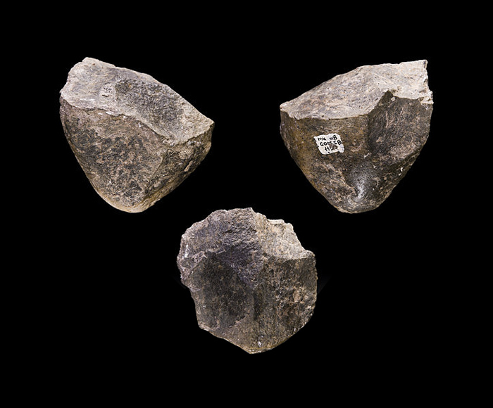
Oldowan Choppers from the Olduvai Gorge

Though the more primitive tools are similar to Oldowan Industrial Complexes, consisting of flakes, cores, and anvils, archaeologist Sonia Harmand of Stony Brook University proposed that the new discovery be labeled Lomekwian technology. Cut marks on animals bones dating 3.4 million years ago suggest that Lomekwian technology also served the same purpose as Oldowan tools, but Sonia Harmand still believes that they must be in a separate category, as they look too different and are too old compared to Oldowan implements to describe the same technology. Human technology is ever-changing but its origin is finally understood.

References:

Balter, Michael. “World’s Oldest Stone Tools Discovered in Kenya.” Science, https://www.science.org/content/article/world-s-oldest-stone-tools-discovered-kenya.

“Homo Habilis: Early Toolmakers.” The Human Journey, 17 June 2020, https://humanjourney.us/discovering-our-distant-ancestors-section/homo-habilis/#:~:text=habilis%20fashioned%20and%20used%20primitive,scraping%20off%20meat%20from%20bones.

Morelle, Rebecca. “Oldest Stone Tools Pre-Date Earliest Humans.” BBC News, BBC, 20 May 2015, https://www.bbc.com/news/science-environment-32804177.

“A Snapshot of Human Origins.” NPR, NPR, 11 June 2003, https://www.npr.org/2003/06/11/1295460/a-snapshot-of-human-origins#:~:text=Homo%20habilis%2C%20which%20actually%20means,than%20the%20Homo%20erectus%20brain.

The Clovis People – Enactivist Theory in Speculation of Archaic Peoples

In the 1920’s and 1930’s, a great number of distinctive stone tools were found near Clovis, New Mexico. Named “Clovis points,” their size and symmetrical shape, along with the indents found on either side of each specimen, indicated that these were spear tips. These Clovis points were often found in close association with mastodon remains, and unequivocal evidence for the hunting of mastodons with these tools was later discovered at a kill site in Kimmswick, Missouri. The only direct evidence of the “Clovis people” available are these sites, and thus we know very little about them (Tankersley, Waters and Stafford 2009, 566). However, by considering what we do know about them and relating it to general characteristics of modern hunter-gather societies, we can infer more about the lives of these ancient people than one might think.

Artist rendition of American mastodon

First, we must establish that the Clovis people were modern humans so that the generalizations made can be applied to them. Besides the fact that it is generally accepted by the scientific community that Homo Sapiens were the only human species to reach the Americas, the Clovis people themselves demonstrated that they are Homo Sapiens through their construction and use of complex tools. In Big Bone Lick, Kentucky, Clovis points were found alongside blade tools, one which was shown to be struck from a prepared polyhedral core made of Fort Payne chert, which was likely found locally (Tankersley, Waters and Stafford 2009, 566). Such tool specialization and complexity in design has only ever been connected with groups of Homo Sapiens. The Clovis people had an end goal in mind before the creation of these tools, and as such they are clear indicators of a level of thinking only matched by Homo Sapiens.

Clovis points from various North American sites

Enactivist theory in cognitive science posits that cognition, and by extension reflections of higher cognition such as social organization and culture, arise from interactions between an organism and its environment. In hunter-gatherer societies, because the subsistence of the society depends wholly on the natural world and one’s ability to navigate it, traditions surrounding the belief that nature and animals are sacred often develop. Thus, using enactivist theory, we can speculate that the Clovis people had a reverence for the mastodon, likely had a pantheon of gods or spirits which coincided with their perceived distinct elements of nature, and lived in closely-knit, mostly egalitarian units which would have facilitated their main method of subsistence, hunting (Evy Van 2020, 306).

Additional Links

3-D computer analysis of Clovis points:

https://insider.si.edu/2012/05/3d-imaging-adds-remarkable-dimension-to-understanding-of-north-americas-clovis-stone-points/

To learn more about finding evidence for mastodon butchery:

https://pennstate.pure.elsevier.com/en/publications/mastodon-butchery-microscopic-evidence-of-carcass-processing-and-

Image Links

Mastodon:

https://www.gear-gear.com/blog/wp-content/uploads/2015/03/Mastodon.jpg

Clovis Points:

https://www.researchgate.net/profile/Matthew-Boulanger/publication/275833717/figure/fig2/AS:614341334282249@1523481796631/Clovis-points-from-various-North-American-sites-Photo-by-Charlotte-D-Pevny-courtesy-M.png

Works Cited

Cauteren, Evy Van. 2020. “Hunting Ideology and Ritual Treatment of Animal Remains             in Hunter- Gatherer Societies: An Enactive Anthropological Approach.” Journal of           anthropological research 76, no. 3 (2020): 296–325. Chicago: The University of               Chicago Press. 

Tankersley, Kenneth B, Michael R Waters, and Thomas W Stafford. Jul., 2009. “Clovis and the American Mastodon at Big Bone Lick, Kentucky.” American antiquity 74, no. 3 (2009): 558–567. Cambridge: Cambridge University Press.

Ireland’s Bog Butter: Pastoralism and Preservation in the Mid Bronze Age

Boglands pock Ireland’s countryside with blankets of undulating, desolate terrain. They are constitutionally bleak: acidic water permeates every nook and cranny of the spongy earth and a thick mop of Sphagnum moss on the surface occludes oxygen and heat, slowing both growth and decay to a frigid lull. But as the Irish, and many other northern communities, have found, boglands make for excellent refrigerators, and in Bronze Age Irish communities where butter was not only a food, but a currency and way of life, bog refrigeration transfixed and delighted.  

A blanket peat bog in Derbyshire, England. Martyn Williams, 2020.

As predominantly pastoralist cultures, Irish communities would migrate with their cattle into the hills during the summer and fall months. This practice, called booleying, capitalized on the late-season surge of grass in the ‘upland’ and gave pastures in the ‘downland’ time to recover from winter and spring grazing. While whole families would often move together (furniture and all), it was almost exclusively the work of girls and young women to milk and tend to cattle. Throughout their several month stay, these women produced butter at a staggering rate, stockpiling for the ‘lean season’ in surplus, when they would use their butter as both a source of nourishment and currency for trade. To keep their precious bounty from going rancid, they turned to bogs: packing the butter first into wooden containers, then burying it deep in the bitter muck.

A 2,325-year-old bog butter weighing almost 30 lbs recovered from Roseberry in County Kildare alongside the keg it was found in. National Museum of Ireland.

When the grass in the hills had been depleted and the cows had grown fat with its sustenance, the pastoral communities would pack up, unearth their hoards of butter, and venture back down from the booley. In the process of leaving, however, they frequently abandoned a container of butter or two, unable to locate them in the bog’s dark turf. Fast forward to the 17th century CE and the emergence of turf cutting in Ireland. As workers carved into the archaic bogs, harvesting crude, carbon-rich peat to burn for fuel and warmth, they occasionally stumbled across wooden containers stained black from tannins. The butter within these rediscovered kegs was notably changed, having hardened and yellowed from thousands of years underground; its taste, reportedly cheesy and acrid. It is rather paradoxical, however, that the desecration of the land which made dairy preservation possible 3,500 years ago is the primary means of learning about it.

Turf cutters harvesting peat from a bog in County Galway, Ireland. iStock Photo.

Now, as archaeologists and turf cutters continue to unearth these parcels, and with the advent of radiocarbon dating, an acting typology for bog butter containers has been established, permitting a more precise chronology of Irish pastoralism and reaffirming the roots of modern Irish civilization in the dairy industry. 

Further Reading:

https://www.smithsonianmag.com/smart-news/a-brief-history-of-bog-butter-180959384/

https://www.jstor.org/stable/26844466

References:

Earwood, Caroline. “Bog Butter: A Two Thousand Year History.” The Journal of Irish Archaeology 8 (1997): 25–42. http://www.jstor.org/stable/30001649.

Costello, Eugene. “The Lost Art of ‘booleying’ in Ireland,” August 31, 2021. https://www.rte.ie/brainstorm/2021/0422/1211486-booleying-ireland-summer-migration/.

Green, Cynthia. “Bog Butter Barrels and Ireland’s 3000-Year-Old Refrigerators.” JSTOR Daily, October 19, 2017. https://daily.jstor.org/irelands-3000-year-old-refrigerators/.

“Irish Bog Butter Proven to Be ‘3500 Years’ Past Its Best Before Date.” Accessed September 25, 2022. https://www.ucd.ie/newsandopinion/news/2019/march/14/irishbogbutterproventobe3500yearspastitsbestbeforedate/.

The Irish Times. “Saving Bogland: Stop Cutting Turf? I’d Say ‘No Way!’” Accessed September 25, 2022. https://www.irishtimes.com/culture/heritage/saving-bogland-stop-cutting-turf-i-d-say-no-way-1.4840017.

Wetherill Brothers and the “The Cliff Palace”

1) “Cliff Palace” at Mesa Verde National Park

Sometimes archaeological discoveries are made by accident. This has happened many times throughout history. A great example with Richard Wetherill and his brother in law Charles Mason. The two were ranchers in Mesa Verde in the southwest Colorado area. On December 18, 1888 the brothers rode to a cliff, herding cattle, where they unexpectedly saw a ruined site built into a cliff. Richard would go on to describe it saying that it was arranged in a way that made it seem like they were “visiting.” Richard came up with the name for this mind blowing site: “The Cliff Palace.”

2) Pueblo Mug

went into the site and found extremely well preserved pieces of pottery and other interesting artifacts. He saw the 150 rooms and 23 kivas that made up the site. Through much more research and work on the dwelling many conclusions were able to be drawn about the people that lived and created this site. Archaeologists determined that the people who lived here were the Ancestral Pueblos from the Pueblo III period. The Ancestral Pueblos were thought to have built the site in the 1200s. They were said to have moved to the area in order to ensure safety and a warmer, drier climate. Living in the cave area also helped keep everything in the site extremely well preserved. The artifacts were protected from pot-hunters and the buildings were protected from weathering effects because of its hidden cliff location. There were an estimated 625 people who lived in this dwelling. The people all had rooms for family and then they would share a Kiva for their ritual gatherings. A Kiva is an underground, excavated room for people to practice their religion. Extended family members would share these in order to perform their ceremonies.

At the Cliff Palace many artifacts were able to be found. It is stated that baskets, sandals, jewelry, textiles, and pottery were found. Pottery being the most important. Pottery showed skill and technology at this time. The Ancestral Pueblos living here were starting to make the pottery multi-colored as well. Another important thing found at Cliff Palace was Macaw feathers. These feathers were extremely significant because they were from Central America, showing trade.

Now Cliff Palace is a part of the Mesa Verde National Park. Thousands of people from around the world come and visit to see the amazing site year round. With these tours the area and buildings have been seeing more rapid deterioration. With this there are conservation efforts in place trying to keep the site as long as possible.

References

Simmons, Marc. “Trail Dust: Mesa Verde Pioneer Richard Wetherill Met a Tragic End.” Santa Fe New Mexican, June 5, 2015.

Yongli. “Cliff Palace.” Articles | Colorado Encyclopedia, May 25, 2016. https://coloradoencyclopedia.org/article/cliff-palace.

“Artifact Gallery.” National Parks Service. U.S. Department of the Interior. Accessed September 25, 2022.

Links

https://www.khanacademy.org/humanities/ap-art-history/indigenous-americas-apah/north-america-apah/a/mesa-verde-cliff-dwellings

https://www.santafenewmexican.com/news/trail_dust/trail-dust-mesa-verde-pioneer-richard-wetherill-met-a-tragic-end/article_bfe75db8-4ba6-56e6-b4d8-aa5eab2d3d7b.html

Receding water levels in the Tigris and Euphrates rivers reveal artifacts, sites and a 3,400 year old city.

The Tigris and Euphrates rivers have existed for as long as we can remember, with their names found in many historical texts of the past, even mentioned in prophecies of the future. The Tigris river runs parallel to the Euphrates River, eventually joining and flowing into the Persian Gulf in the lowlands in an area known as Shatt Al-Arab (Sweeney, 2022). These two rivers, along with river Nile of northeastern Africa supply the Fertile Crescent, which is a rich soil area of the Middle East, and the cradle of civilization. Both rivers are also known for their relation to Mesopotamia (a land between two rivers, namely Tigris and Euphrates), which is located in the Fertile Crescent (Figure 1).

Figure 1: Map of the Fertile Crescent. via Getty Images.


These rivers are referenced in books like the Bible and Hadith during the creation of all things, and are even included in prophecies about the end of time, which gives testament to their longevity. But for the past few years, the great rivers Tigris and Euphrates of the Middle East are experiencing one of their lowest levels in history, with the threat of them both running completely dry within two decades due to human activity and climate change (figures 2). (Cheeseman, 2021)

Figure 2: An aerial view of the Tigris river.  via Jordan News, 2022.


Nevertheless, the drought arrived with some benefits, especially in the realm of archeology. Many artifacts are being unearthed from both the Tigris and Euphrates rivers, which are dating back thousands of years, most notably a 3,400 year old city. This settlement emerged from the waters of the Tigris river, specifically the Mosul reservoir, which is located in northern Iraq (once known as Saddam Dam) earlier this year as the water levels dropped due to the extreme drought present in the area. Archeologists discovered sites and artifacts dating back to the Mittani Empire era of the Bronze Age, specifically between 1550 and 1350 BC, and that the urban center containing large buildings and palaces could be an ancient city called Zahiku. (Golder et al., 2022) The Mittani Empire was once a very prosperous nation, comparable to the likes of Assyria, Egypt and Babylon, and ruled over the northern Euphrates-Tigris region and stretched from present-day northern Iraq, through Syria and into Turkey. (Mark et al., 2021).

A class-based hierarchy existed in this kingdom, with the ruling class known as Maryannu. Their downfall was caused by the invasion and subsequent occupation of these neighboring kingdoms who sought to break their hold on their extensive trade routes. Due to fear of rising water levels in the dam once more, archeologists quickly mapped the city (figure 3), which was “astonishingly well preserved” despite being made of unfired clay, and survived more than 40 years of being underwater (UNIVERSITY OF TÜBINGEN, 2022). The city found in Mosul Dam was destroyed by an earthquake at around 1350 BC, and eventually submerged due to the rising water levels resulting from the construction of the dam in the 1980s (Tarzi, 2022).

Figure 3: Archeology at the Mosul Dam, Tigris River. via UNIVERSITY OF TÜBINGEN.

On the Euphrates side of things, the receding waters have uncovered more than 80 historical sites that included jails and cemeteries belonging to an ancient city of Telbas, which date back to before Christ. According to Shafaqna Persian (2022) Telbas prison (figure 4) is actually a collection of graves belonging to the Assyrian period.

Figure 5: “Telbas Prison”: The tombs of the Assyrian period. via Shafaqna Persian. 

Even as the rivers are at threat of disappearing, they are still providing. At the threat of disappearing we are still being given valuable resources. If the water levels of these two rivers continue to lower, we will continue to find more historical artifacts and sites that bring a different value to the world, but at a great cost. 

Further Readings: 

Cradle of civilization

History of Tigris and Euphrates

Era of the Mittani Empire

Dropping water levels reveal new archeological sites, artifacts in Euphrates, Tigris rivers

References

Cheeseman, Abbie. 2021. “Iraq’s mighty rivers Tigris and Euphrates ‘will soon run dry.’” The Times. https://www.thetimes.co.uk/article/iraqs-mighty-rivers-tigris-and-euphrates-will-soon-run-dry-q5h72g5sk

Golder, Joseph, Newt Gingrich, Michael Medved, Daniel R. DePetris, and Josh Hammer. 2022. “Archaeologists Rush to Investigate 3,400-Year-Old City Emerging From Tigris River.” Newsweek. https://www.newsweek.com/archaeologists-rush-investigate-3400-year-old-city-emerging-tigris-river-1711827

Mark, Joshua J., Simeon Netchev, and Gwendolyn Leick. 2021. “Mitanni.” World History Encyclopedia. https://www.worldhistory.org/Mitanni/

Recker, Jane. 2022. “Drought in Iraq Reveals 3,400-Year-Old City | Smart News.” Smithsonian Magazine. https://www.smithsonianmag.com/smart-news/drought-in-iraq-reveals-3400-year-old-city-180980188/

Shafaqna Persian. 2022. “Iraq: Lowering Euphrates water level reveals underwater ancient areas.” International Shia News Agency. https://en.shafaqna.com/274459/lowering-euphrates-water-level-reveals-80-under-water-ancient-areas-in-western-iraq/

Sweeney, Jane. 2022. “Tigris River.” National Geographic Society. https://education.nationalgeographic.org/resource/tigris-river

Tarzi, Nazli. 2022. “Zakhiku, Iraq’s ‘Atlantis on the Tigris’ revealed by drought.” The New Arab. https://english.alaraby.co.uk/features/zakhiku-iraqs-atlantis-tigris-revealed-drought

UNIVERSITY OF TÜBINGEN. 2022. “A 3400-year-old city emerges from the Tigris River | University of Tübingen.” Uni Tübingen. https://uni-tuebingen.de/en/university/news-and-publications/press-releases/press-releases/article/a-3400-year-old-city-emerges-from-the-tigris-river/.

Understanding Past Societies: Ethnoarchaeology in the Makran Sefidkuh Region

In order to truly understand the past, it is necessary to determine the social nature of early societies. A prime field of study that aids in this analysis is ethnoarchaeology. Ethnoarchaeology examines experiences, artifacts, and any existing structures in present, living societies to draw inferences about the past. This study also requires the archeologist to ask questions that go beyond what is apparent in archaeological records (Renfrew and Bahn 2018, 143-148). 

As archaeologists are always looking to learn more about the past, there are constantly new discoveries being made around the world. Over the past few years, the Makran Sefidkuh mountains of the Baluchistan region of Iran have been analyzed using ethnoarchaeology. In 2016, Hossein Vahedi began conducting an archeological survey on the region as part of his thesis at Shahrekord University. Later, he continued his work and began an ethnoarchaeological project through the Public Relations Institute of Cultural Heritage and Tourism. The goal of the ethnoarchaeological project was to survey the living communities in the ​​Makran Sefidkuh region and to identify settlement continuity patterns. Having a combination of desert and mountain climates, along with the Paleolithic, Chalcolithic, and Islamic cultures present, the Sefidkuh area was especially interesting to the archaeologist (Vahedi 2020).

Figure 1. Map created to show the region being surveyed (Vahedi 2020).

Within the mountain region, 12 current settlements were identified. Some of the present buildings are circular, and some are ovular. They were constructed out of various materials, primarily mud and stone. A survey of the region revealed items such as pottery fragments, circular gravestones, and Islamic glass bracelets and cemeteries. The circular gravestones resemble that of those discovered in Oman and Pakistan. Due to the proximity of Sefidkuh to these countries, it is speculated that it was a major area of trade between the Baluchistan and Sistan communities and the Persian Gulf’s smaller, southern communities. Supporting this theory is that the pottery found was one of the Baluchistan’s special index potteries, Londo. Londo pottery has been found in Fras, Pakistan, and other sites, for it is one of the most substantial pottery groups in the Makran region and neighboring areas (Heritage Daily 2020). Additionally, it is believed because of the seemingly permanent settlements, yet strategic significance of the location for trade, that Sefidkuh has been home to many groups of semi-sedentary nomadic people (Heritage Daily 2020). This would imply that the inhabitants of the region were mostly mobile, but also lived in these permanent settlements for at least some of the year. 

Figure 2. One of the circular houses in the region (Vahedi 2020).

Although the specifics of the past communities in Sefidkuh are yet to be identified, it is the study of ethnoarchaeology that allows for the societal mysteries of the past to be uncovered using what is available today. Without this methodology, our understanding of the present day Baluchistan region would just be basic knowledge of archeological finds, there wouldn’t be as much interpretation of its predecessors. 


References:

Heritage Daily. “Archaeological Survey and Ethnoarchaeological Studies in Sefidkuh of Makran, Iran.” HeritageDaily, May 13, 2020. https://www.heritagedaily.com/2020/05/archaeological-survey-and-ethnoarchaeological-studies-in-sefidkuh-of-makran-iran/129091. 

Renfrew, Colin, and Paul Bahn. 2018. Archaeology Essentials: Theories, Methods, and Practice. Fourth edition. Thames & Hudson.

Vahedi, Hossein. “Ane Today – 202008 – the First Archaeological and Ethnoarchaeological Survey Project in the Sefidkuh Makran Mountains of Baluchistan.” American Society of Overseas Research (ASOR), August 21, 2020. https://www.asor.org/anetoday/2020/08/survey-baluchistan. 

Further Readings:

https://link.springer.com/referenceworkentry/10.1007/978-1-4419-0465-2_284#:~:text=Although%20the%20term%20ethnoarchaeology%20was,interested%20in%20ethnographic%20analogy%20in

Research Scholar


The Kachina: Influence and Worship in Pueblo Society

Mistaken by Spanish colonizers as satanic worship, the kachina figure was an integral part of the culture of the Pueblo People. Consisting of indigenous tribes including the Hopi, Zuni, Acoma, and Laguna, the Pueblo People occupied much of the Southwestern United States. They were largely farmers and hunters, leaving behind important archaeological sites such as underground kivas, cliff dwellings, pottery, and kachina dolls. These items played an important role in Pueblo religion and culture.

To the Pueblo People, nature was personified as entities known as the kachina. They represented anything from stars to various animals to even other tribes, and tended to be expressed in three ways: as spiritual beings, as masked dancers, and as dolls. The kachina were credited with first teaching humans–specifically the Hopi–how to make tools, hunt, use medicine, and live off the land. To the Pueblo People, the kachina were rain-bringers who stayed with the tribe for half of the year, serving as spiritual guides and influencing the harvest. 

Actual ritual worship of the kachina heavily depended on men. Men were the only ones allowed to don kachina masks and dance in the kivas. Kachina masks were thought of as containing a kachina’s spiritual essence, and therefore allowed said kachina to temporarily inhabit the body of the dancer. Through dance, specific spirits would be able to hear the prayers of the people, and men would be able to communicate with the entities themselves. 


Figure 1– Ho-ote Kachina Dance (Kabotie 2008)


The second prominent way in which the Pueblo People honored the kachina was with dolls. Originating with the Hopi tribe, sacred kachina dolls were carved from cottonwood roots, which were then painted using natural minerals. These figures were given to young Hopi girls during ceremonies, then hung on walls or used in other ways to decorate and watch over a home. The dolls were often passed down through families, generation after generation. As men were the only ones allowed to participate in kachina ceremonies in underground kivas, kachina dolls served as a way to keep the kachina spirits relevant to the rest of the Pueblo People. 


Figure 2– Kachina Doll (Brooklyn Museum, 1903)


Evidence of kachina art began to appear in the archaeological record as early as 1150 AD, with discoveries in the Puerco Ruins. Definitive representations of kachina in Hopi pottery began appearing in the 1300s, and extended into the 1400s. Similarly, by 1325, there were rock art depictions of kachina masks and dancers. As mentioned earlier, we also see Spanish interaction with the kachina. Colonists’ accounts record seeing “satanic paraphernalia” on display in the homes of Pueblo People–likely these were kachina dolls. Into the mid 1800s and beyond, kachina dolls were sold in the marketplace, and became accessible to non-Pueblo People. Following this, there began to be photo documentation of the kachina dolls and more archaeological research into their history. 

Appearing as dolls and in ritual regalia and practices, the kachina held an enormous role in Pueblo society and were an outlet for the agricultural society to pray for good harvests, rains, and natural conditions.


References: 

Blake Weiner, James. Kachina Cult. World History Encyclopedia, January 16, 2019, https://www.worldhistory.org/Kachina_Cult/ 

The Editors of the Encyclopedia Britannica. Kachina. August 30, 2021, https://www.britannica.com/topic/kachina 

The Editors of the Encyclopedia Britannica. Pueblo Indians. May 15, 2020, https://www.britannica.com/topic/Pueblo-Indians 

Pueblo Native Americans: Their History, Culture, and Traditions. Native Hope, April 19, 2021, https://blog.nativehope.org/pueblo-native-americans-their-history-culture-and-traditions 

Weiser-Alexander, Kathy. Kachinas of the Puebloans. Legends of America, November 2021, https://www.legendsofamerica.com/na-kachina/ 


Further Readings: 

Richard H. Wilshusen, Ancestral Puebloans of the Four Corners Region, Colorado Encyclopedia, September 09, 2020, https://coloradoencyclopedia.org/article/ancestral-puebloans-four-corners-region

Weiser, Kathy. Kachina Types and Ceremonies. Legends of America, November 2019, https://www.legendsofamerica.com/na-kachinatypes/2/ 


Stonehenge: Why and How it Was Built

Stonehenge is a prehistoric monument constructed from large, vertically oriented rocks. The megaliths are positioned in a pair of concentric circles, two horseshoes within, and an altar stone at the center. Construction began in around 3000 BCE and a second round began around 500 years later (Pearson 2022). For years scientists, archaeologists, and artists have debated how and why it was constructed, their theories ever changing (Pitts 2022). To this day, many people travel to Salisbury Plain in Wiltshire, England to visit the site and ask their own questions about its long and often debated history (History Staff 2013).

Figure 1. Stonehenge at dawn. Photograph taken by National Geographic photographer.

The reason for Stonehenge’s construction is widely debated. In the 17th and 18th century, archaeologists suspected that the site had been constructed by the ancient Celtics, the Druids (History Staff 2013). However later technology proved it impossible due to the fact that the Druids arose around 2,000 years after the initial construction  (History Staff 2013). An 18th century scholar hypothesized that it could be a sort of calendar, as the sun on the summer solstice directly hits the entrance to the monument (History Staff 2013). Other hypotheses have included that it was an ancient place of healing, while others believed it was the center of bronze-age chiefdoms (Pearson 2022). In recent digs, archaeologists have discovered hundreds of human remains that  span nearly 1000 years  (History Staff 2013). From this, intellectuals have identified Stonehenge as likely both a site for ceremonial customs and burials (History Staff 2013). In 2010, a second stone circle was discovered in a similar orientation which led scholars to suspect that Stonehenge might have represented a larger-spread ritual (History Staff 2013).

Figure 2. Artistic depiction of Stonehenge at its completion versus today. Retrieved from eatandtravelwithus.

There were 2 main type of stones located at Stonehenge: Bluestones and sarsens (Pitts 2022).

The so-called bluestones form the inner horseshow and inner circle at Stonehenge (Pitts 2022). It’s estimated that those stones formed the entirety of the monument for about 500 years before the larger stones arrived (Pitts 2022). Although it’s name suggests an obvious blue color, the stones really only had a blue tint that was more prominent when wet or freshly cut (English Heritage). Unlike the later stones, these stones likely had a long journey to the site; some traveled almost 250 miles (English Heritage). These stones ranged from 2-5 tons each, so were no small feat to transport (Pitts 2022). A few of these bluestones also likely stood in other henges across England prior to their placement at Stonehenge (English Heritage). At Stonehenge itself, archaeologists have found evidence that the current position is at least the second configuration the bluestones have had since their arrival (English Heritage).

Figure 3. Example of the bluestone at Stonehenge. Retrieved from Stonehenge Stone Circle UK.

The larger stones in the outer ring and second horseshoe of the monument are the sarsens (Pitts 2022). Based on core research done by scientists, the majority of these stones seem to have come from about 20 miles from the site (Pitts 2022). These stones are much larger than the bluestones and weigh 20 or more tons each. The transportation of these stones would have been a massive undertaking (Pitts 2022). Unlike the bluestones, the sarsens are not in their natural states (Pitts 2022). Instead, they have been carefully carved nearby and fit together on site (Pitts 2022). Because of the tremendous size of the sarsens, there has been much speculation about how they were placed. Many theorized that they did so with ropes, however Pitts points out that because of the close proximity of the stones there would likely not have had room to do this (Pitts 2022). Instead, they likely rocked to stone back and forth while building a wood pile underneath to raise it.

Figure 4. Artist’s depiction of how the stones could’ve been raised. This depiction goes against what Pitts hypothesized. Either way, the process would’ve been extremely time consuming and often dangerous. (English Heritage)

Although Stonehenge is still an impressive monument to visit, it is by no means untouched (Pitts 2022). Over the years many of the stones have been carved up and taken elsewhere (Pearson 2022). Also, by the beginning of the 20th century, 5 stones had fallen and more teetered. In recognition of the importance of this monument there was restoration work done to keep the megaliths erect (Pitts 2022). However, the digging required destroyed large portions of the archaeological evidence that lay beneath the stones (Pitts 2022).

Although built thousands of years before the present, the secrets of Stonehenge continue to be studied and likely will be for many decades to come.

Further Readings

References

English Heritage. “Building Stonehenge.” English Heritage, https://www.english-heritage.org.uk/visit/places/stonehenge/history-and-stories/building-stonehenge/#:~:text=Bluestone%20is%20the%20term%20used,2%20and%205%20tons%20each.


History Staff. “Why Was Stonehenge Built?” History.com, A&E Television Networks, 10 Apr. 2013. https://www.history.com/news/why-was-stonehenge-built.


Pearson, Mike. “Stonehenge.” Encyclopædia Britannica, Encyclopædia Britannica, Inc., 24 Aug. 2022. https://www.britannica.com/topic/Stonehenge#ref285591.


Pitts, Mike. “How Was Stonehenge Built?” The British Museum, The British Museum, 16 Feb. 2022. https://www.britishmuseum.org/blog/how-was-stonehenge-built.


Dental Archaeology: How the Examination of Excavated Teeth Contributes to Knowledge

Human teeth, comprised of two of the hardest materials made by the human body, generally withstand the test of time and a thus a great resource for archaeologists seeking to understand how those in previous times lived—primarily through what they ate.

Archaeologists employ several visual techniques when analyzing ancient incisors. Dental wear and tear is a function of type of diet, masticatory forces and the non-masticatory use of teeth. To determine the diet a person subsisted on, archeologists examine the pattern of wear as well as specific markings left on the tooth, otherwise known as dental microwear. Archaeologists utilize resin impressions, microscopes, and 3D topographical scans in order to obtain a close-up view. Striations left on the enamel, in the form of pits and scratches, indicate whether a person ate hard brittle food or tough food that required mandible sheering. Striations can also help archaeologists conclude if the person was living off of a meat or vegetable diet. If a tooth has primarily vertical striations, this would demonstrate a meat diet. Both vertical and horizontal striations, however, are indicative of a vegetable diet

Dental microwear shown through a 3D topographical texture analysis scan

Dental analysis can also be done using the naked eye. This form of archaeological analysis, dental macrowear, can indicate overall nutrition and health, as well as other important factors like age. Archaeologists fashion molds of teeth through non-invasive pouring and casting techniques. Close analysis of these can show the person’s chewing cycle, or tooth wear through grinding. The presence of tooth decay and loss is a main indicator of a person’s health and what food they primarily subsisted off of. A carbohydrate rich diet will be indicated through a greater presence of degenerative changes. This decay also helps archeologists date when specific communities of hunter-gatherers transitioned to an agricultural way of living.To determine age, archaeologists look towards the overall the size, shape, growth, and placement of teeth within the skull. Tooth calculus, or the accumulation of plaque, also help with concluding age for the plaque builds up with time. The number and type of tooth eruptions are also examined, for fewer eruptions indicate that the person was of a younger age at the time of death.

Photo simulations of buccal macro surface wear

Genetic information as well as location and culture can also be garnered through the close archaeological analysis of excavated teeth. Even after thorough bodily decomposition, it is often possible to extract DNA from human teeth. This can then be used to uncover genetic makeup which then helps archaeologists trace lineage and migration patterns. Changes in climate and other historical trends often are indicated by some form of immigration pattern. DNA also provides information on populations that suffered mass disease epidemics. Dental modifications also help archeologists reveal cultural practices. Examples of such include teeth inlayed with decorative jewels and stones, dental etching and filing, and teeth staining.

Further readings:

https://corkarchaeologist.com/2019/10/04/some-dental-morphological-characteristics-of-irish-archaeological-populations-an-aid-to-biological-affinity-and-the-origins-of-the-irish/

https://www.npr.org/sections/thesalt/2016/10/25/497094756/dental-detectives-what-fossil-teeth-reveal-about-ancestral-human-diets

References

“Dental Archeology.” Konikoff Dental Associates. Accessed September 25, 2022. https://konikoffdental.com/dental-archeology/.

“Dental Bioarchaeology.” Dental One Associates . Dental One Associates . Accessed September 25, 2022. https://www.dentalone-md.com/locations/baltimore-beltway/dental-bioarchaeology/.

“A Guide to Dental and Bioarchaeology.” Rye Smiles for Life. Rye Dentistry . Accessed September 25, 2022. https://www.ryesmilesforlife.com/a-guide-to-dental-and-bioarchaeology/.

Mahajan, Sangeeta. “Ancient Asia.” Ancient Asia. Ubiquity Press, October 23, 2019. https://www.ancient-asia-journal.com/articles/10.5334/aa.181/.

Saraceni, Jessica Esther. “Tooth Decay Troubled Moroccan Hunter-Gatherers.” Archaeology Magazine. Archaeology . Accessed September 25, 2022. https://www.archaeology.org/news/1701-140107-morocco-teeth-decay.

Strangeremains. “Stylish Deformities – Dental Edition.” Strange Remains. Strange Remains , March 10, 2015. https://strangeremains.com/2014/08/26/stylish-deformities-dental-edition/.


Art vs Artifact

What is it that differentiates a pot found underground from thousands of years ago from the ones on a pedestal in museums like the MET? What are the guidelines that consider one as an artifact of the past and one as a piece of art? Or can one object be both?

The textbook definition of an artifact is a “humanly made or modified portable object, such as stone tools, pottery, and metal weapons.” (Renfrew et al. 2018). This definition renders the aesthetic and skill level aspect of a found object to be irrelevant, making an artifact considered anything created by humans.

However, art is defined as “something that is created with imagination and skill and that is beautiful or that expresses important ideas or feelings” (Britannica Dictionary). Taking into account the beauty and expression of an object, many artifacts may fall out of place, but there is definitely overlap between the two. A simple stone vessel with no other intention than to store meat in the winter would likely have no beauty and communicate no ideas of the time, and thus is not art. However a carved stone such as the Venus of Willendorf is now considered one of the oldest surviving works of art.

Venus of Willendorf, (photo: Steven Zucker, CC BY-NC-SA 2.0)

The Venus of Willendorf, carved from limestone circa 24,000 BCE, is a 4.5 inch tall female figurine. She was named after the Roman goddess of love and beauty, although there is no relation or evidence that she represents that, because of her emphasized reproductive features and understated face and limbs (Zygmont 2015). Although her purpose is unknown, this figure is palm sized and would have been very easy to transport, just as other artifacts of the time. However, it is the aesthetic qualities and the unknown yet clearly existing intentions that went into making her that turn this piece of stone into an artwork that is now on display in the Naturhistorisches Museum of Vienna.

As a form of expression, artwork can offer much more information than just what people needed to live in prehistoric times, but also what they found to be important. From the Venus of Willendorf, we can see that this nomadic society had given an importance to women’s ability to reproduce, as the piece seems to reference fertility.

Ai Weiwei, Dropping a Han Dynasty Urn, 1995 (photo: © Ai Weiwei)

As art can be archaeology, archaeology can also be art. In 1995 Chinese artist Ai Weiwei created the photography series Dropping a Han Dynasty Urn, in which he drops a 2000 year old ceramic urn against the ground, shattering (Beres 2020). Giving this urn a new significance even in destruction, this piece emphasizes how important it is to remember and preserve the past.

Further Reading:
Paleolithic Art, An Introduction 
The Case for Ai Weiwei


References:
“Art Definition & Meaning | Britannica Dictionary.” Accessed September 25, 2022. https://www.britannica.com/dictionary/art.

Beres, Tiffany Wai-Ying. “Ai Weiwei, Dropping a Han Dynasty Urn .” Smarthistory, August 25, 2020. https://smarthistory.org/ai-weiwei-dropping-a-han-dynasty-urn/.

Renfrew, Colin, and Paul Bahn. 2018. Archaeology Essentials: Theories, Methods, and Practice. Fourth edition. Thames & Hudson.

Zygmont, Bryant. “Venus of Willendorf .” Smarthistory, November 21, 2015. https://smarthistory.org/venus-of-willendorf/.