Exploring the Mormon Pioneer Trail

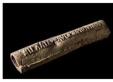
Eight hundred years after its glory the Cahokians brought about, Illinois nurtured another group of faithful pilgrims, venturing from Nauvoo, Illinois to Utah: the Mormons. However, their pilgrimage was different from that of those who walked days and nights towards Cahokia from the Emerald Acropolis: they were forced to move by religious persecution. Their aim was to find a new homeland where they could establish churches and reside in peace. The pilgrimage lasted for as long as 23 years (Haury-Artz 2016), over the length of 1415 miles (National Park Service 2019), a trail now called the Mormon Pioneer Trail, commemorated by the state government and celebrated by the National Geographic as one of the top 10 historic pilgrimages across the world (National Geographic). It is also known as one of the greatest Euro-American immigration in history, crossing both the Great Plains and the Rocky Mountains (Haury-Artz 2016).

The first wave of the journey started on February 4th, 1846. Led by approximately 500 leaders, a population of 70,000 Mormons migrated from Nauvoo towards Salt Lake City, Utah (Mormon Historic Sites Foundation). The cold weather made the pilgrimage difficult, not to mention the geographical condition, and by the spring of 1847, already 400 lives had been taken by the harsh condition (University of Nebraska Lincoln). Throughout the whole journey, the Mormons travelled mostly by wagons, handcarts and by foot. Along the way, many camps were established as temporary settlements. For example, the Locust Creek Camp is one of their stopping points soon after the journey started in 1846, and also where “Come, Come Ye Saints” was written. The song is now the most well-known hymn of the Mormons and even an anthem to the pilgrims of that era, encouraging them to keep going with the support of faith. The handcart expedition took a slightly different track than the ones who travelled by wagons. This path included a number of camps as well, but above that, a few handcarts crafting sites were discovered – the Mormon Handcart Park, for instance, marked a settlement as well as a site where people built their handcarts for the travel. When the Mormons were to cross the Missouri River, they took ferries, the most used of all being the North Ferry, while the handcart travellers crossed the Des Moines River by not only ferry, but also floating bridges believed to be by Grand Avenue. Meanwhile, alternative routes were also taken when on-land conditions were too difficult, or when rivers were hard to cross (Haury-Artz 2016). The trails are illustrated as below:

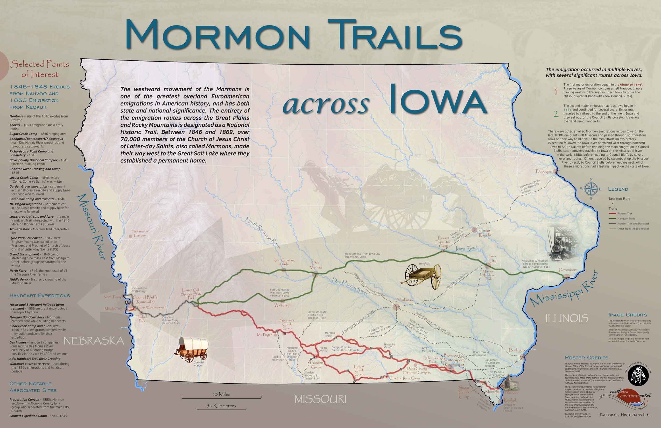
Figure 1 – Mormon Trails Across Iowa (Haury-Artz 2016)

Archaeologists were evidently involved in the studies of this great pilgrimage: “Site records, historical documents, and map resources were examined” with previous studies. While aerial photographs of GIS technology was used to further determine the exact route of the travel, LiDAR images were also taken to clearly illustrate the trails the Mormons left behind. Moreover, land surveys and explorations took place to locate some distinctive and special campsites, such as cemeteries of the ones who did not survive the journey, inns and cabins built for better-sheltered settlements (Haury-Artz 2016).

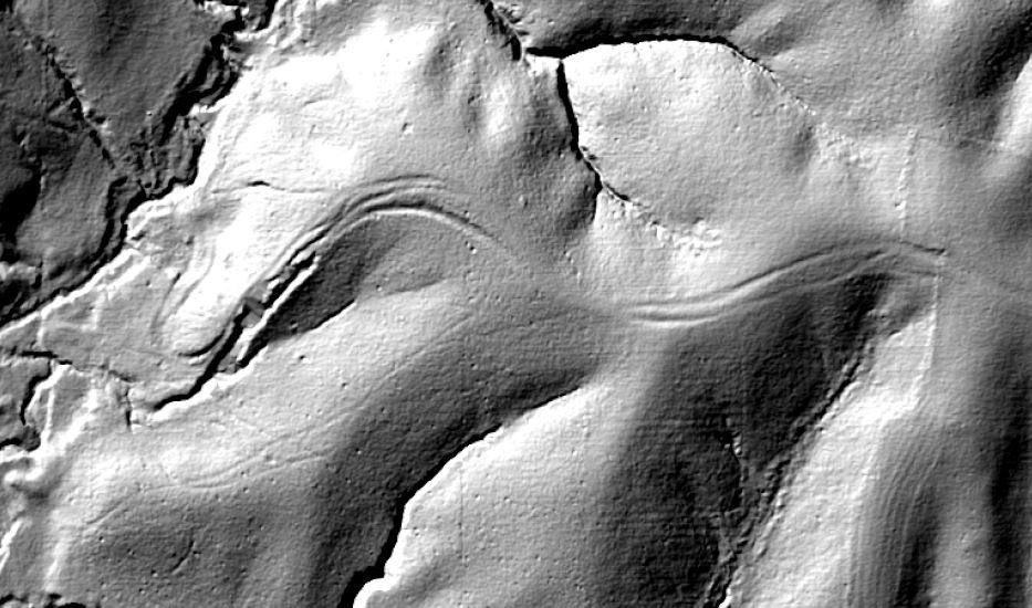
Figure 2 – LiDAR image of the Mormon Trail (Haury-Artz 2016)


For further readings on the Mormon Trail:

  1. https://utah.com/mormon/pioneer-trail-history
  2. https://archive.org/details/historicresource00kimb/page/6


References:


Haury-Artz, Chérie

  2016  Exploring Mormon Trails Across Iowa. Electronic Document,

  https://archaeology.uiowa.edu/exploring-mormon-trails-across-iowa, accessed November

  24, 2019.


Mormon Historic Sites Foundation

  Mormon Iowa Trail. Electronic Document, http://mormonhistoricsites.org/mormon-iowa-trail/,

  accessed November 24, 2019.


National Geographic

  Top 10 Historic Pilgrimages. Electronic Document,

  https://www.nationalgeographic.com/travel/top-10/pilgrimages-sacred-journeys/#close,

  accessed November 24, 2019.


National Park Service

  2019  Mormon Pioneer: Maps. Electronic Document,

  https://www.nps.gov/mopi/planyourvisit/maps.htm, accessed November 24, 2019.


University of Nebraska Lincoln

  The Mormon Trail. Electronic Document,

  https://cdrhsites.unl.edu/diggingin/trailsummaries/di.sum.0006.html, accessed November

  24, 2019.


Images:


Haury-Artz, Chérie

  2016  Exploring Mormon Trails Across Iowa. Electronic Document,

  https://archaeology.uiowa.edu/exploring-mormon-trails-across-iowa, accessed November

  24, 2019.

Safety and Settlement in the Great Dismal Swamp

As conveyed by its name, the Great Dismal Swamp in southeastern Virginia is an inhospitable place. Throughout the region’s colonization, the swamp was considered a “twisted and dark natural landscape” to be avoided whenever possible (Sayers 2014:82). These features helped establish it as a place of migration for runaway slaves, historically known as “Maroons.” The security provided by the swamp’s isolation allowed them to create self-organized communities that spanned generations. With only passing mentions in the historical narrative of slavery and liberation, the Great Dismal Swamp was primarily thought of as a temporary stop on the Underground Railroad (Grant). Despite these misconceptions, recent archaeological research has contributed a better understanding of how the insular communities thrived outside of the existing slave-based economy. 

The Great Dismal Swamp was known to the Algonquin people for thousands of years. After their displacement during Virginia’s colonization, scattered bands of Native Americans resettled in the marshes. Shortly after the introduction of slavery in 1619, runaway slaves migrated to the swamp in search of safety. Their presence predominates the archaeological record of the swamp between 1680 and the Civil War (Grant). Later on, colonists began to extract the swamp’s natural resources through logging and canal digging, including a project undertaken by George Washington (Figure 1). Their commercial efforts likely had the effect of pushing the communities further into the swamp.

Figure 1: A marker indicating the site of George Washington’s Canal Project. Photograph by Allison Shelley.

Efforts to excavate the Great Dismal Swamp are led by Daniel Sayers, a professor at American University. Beginning in 2003, the Great Dismal Swamp Landscape Study has identified eight archaeological sites of interest. Most of Sayers’ research focuses on the “nameless site,” a 20-acre island located two miles in the swamp’s interior (Sayers 2014:25). Evidence recovered from the site includes the foundations of seven cabins and several thousand artifacts, suggesting that it was used as a permanent settlement. Interestingly, Sayers has identified a material culture practiced by the communities. Due to their isolation from the outside world, inhabitants used debitage to continuously repurpose stone tools left behind by Native Americans (Figure 2) (Grant). 

Figure 2: An example of a repurposed arrowhead. Photograph by Jason Pietra.

Researching the Dismal Swamp communities presents a unique set of challenges, mainly due to the nature of the swamp. The very conditions that discouraged outsiders from traveling into the swamp’s interior have slowed excavations. Sayers’ team must contend with the heat, mud, insects, and thick vegetation associated with the region. Furthermore, because of their material culture, most of the recovered artifacts are incredibly small. According to Sayers, “Everything we’ve found would fit into a single shoe box… they were using organic materials from the swamp. Except for the big stuff like cabins, it decomposes without leaving a trace” (Grant).

The significance of the Great Dismal Swamp research project cannot be understated. By focusing on the swamp, it restores the history of a forgotten community that fleed racial tyranny and seized control of their destiny.

References Cited

Grant, Richard

  2016  Deep in the Swamps, Archaeologists Are Finding How Fugitive Slaves Kept Their Freedom. Electronic Document, https://www.smithsonianmag.com/history/deep-swamps-archaeologists-fugitive-slaves-kept-freedom-180960122/, accessed November 23, 2019.


Sayers, Daniel O.

  2014  A Desolate Place for a Defiant People: The Archaeology of Maroons, Indigenous Americans, and Enslaved Laborers in the Great Dismal Swamp. University Press of Florida, Gainesville, Florida.

Images

Grant, Richard

  2016  Deep in the Swamps, Archaeologists Are Finding How Fugitive Slaves Kept Their Freedom. Electronic Document, https://www.smithsonianmag.com/history/deep-swamps-archaeologists-fugitive-slaves-kept-freedom-180960122/, accessed November 23, 2019.

Further Reading

To listen to a podcast episode about the Great Dismal Swamp communities:

The Great Dismal Swamp

To learn more about the history of the Underground Railroad:

https://www.nps.gov/subjects/ugrr/discover_history/index.htm


Isotope Analysis: An Archaeological Investigation of Little Miss Lake Panasoffkee

In 1971, a woman’s body was found floating through Lake Panasoffkee in central Florida. Local detectives were able to extract very little information from the scene: Jane Doe was roughly 17 to 24 years old, potentially white or Native American, and seemed to have previously given birth (Phipps 2018). After much investigation, the authorities found only a belt wrapped around the victim’s neck, but otherwise no other evidence of her identity or killer. Jane Doe—otherwise known as “Little Miss Lake Panasoffkee”—was subsequently buried in anonymity. However, just over a decade later, the young woman was exhumed and examined once more, this time with the power of archaeology on her side.

Figure 1 – University of South Florida’s approximate reconstruction of Little Miss Lake Panasoffkee (Gordon 2012).

To gather more information, Dr. Erin Kimmerle, a forensic anthropologist and bioarchaeologist at the University of South Florida, employed archaeological techniques: rather than simply studying food residue, which might not survive over time, she used isotopic analysis on Jane Doe’s teeth. Through this method, she was able to inspect the minerals and particles within the enamel of Jane Doe’s teeth and found traces of lead (Gordon 2012). Because teeth only absorb isotopes during the years in which they are still in development, it was imperative to consider this data within the context of Jane Doe’s childhood (estimated to be around 1950). Both the United States and Europe used leaded gasoline at this time, allowing traces of lead to infiltrate soil and food, eventually making its way into tooth enamel. However, each had a different source and thus a different signature. The signature of Jane Doe’s lead-infused enamel was compatible with Europe’s lead signature, insinuating the victim to have originally hailed from Europe (Phipps 2012). Further investigation of the teeth revealed a large presence of oxygen isotopes, suggesting she had lived in an area with a coastline like Greece (Gordon 2012).


Figure 2 – diagram of isotope consumption with strontium as an example (Machicek 2013).

Although Jane Doe has yet to be fully identified, this data brings the authorities one step closer to cracking her case: from the teeth alone, anthropologists were able to estimate her place of origin. The effects of isotopic analysis cannot be overstated: other disciplinessuch as forensic anthropology in the case Little Miss Lake Panasoffkee—have even begun to adopt this type of archaeological method. Through isotopic analysis, it is possible to not only reconstruct an individual’s diet, but also their geographic origin. Thus, the significance of this technique lies in its ability to inform us on one’s environment. In essence, isotopic analysis of teeth does not only aid archaeologists in interpreting sites of the past, but can also help enforce justice in the present.


Reference List:

Gordon, James

2012 Isotope Analysis Provides Clues in a Florida Cold Case. Electronic document, https://www.nytimes.com/2012/11/13/science/isotope-analysis-provides-clues-in-a-florida-cold-case.html, accessed November 23, 2019. 


Phipps, Jordyn

2018 Who Is Little Miss Panasoffkee?. Electronic document, https://www.theodysseyonline.com/little-miss-panasoffkee, accessed November 23, 2019.


Images:

Figure 1:

Gordon, James

2012 Isotope Analysis Provides Clues in a Florida Cold Case. Electronic document, https://www.nytimes.com/2012/11/13/science/isotope-analysis-provides-clues-in-a-florida-cold-case.html, accessed November 23, 2019.

Figure 2:

Machicek, Michelle

2013 Isotope Analysis Time Team America. Electronic document, https://www.pbs.org/time-team/experience-archaeology/isotope-analysis/, accessed November 23, 2019.

Further Reading:

To read more on the science behind isotopic analysis of teeth and its applications:

https://www.ncbi.nlm.nih.gov/pmc/articles/PMC4541412/

To read more on overlapping techniques of archaeology and forensics:

https://daily.jstor.org/forensic-archaeology/

Native American Astronomy: Skidi Pawnee

Long before the invention of GPS or compasses, people already starts their journey. How? Instead of looking into the screen, they look up into the night sky seeking for answers from these eternal light beeds. In fact, before anyone understand what stars are, people had already formed their own belief about them. In North America, aboriginal tribes have different views on the meaning of stars. Some believe that the night sky has spiritual significance, and some believe that twinkling objects have similar human characteristics. Astronomy played an important role in the early native American culture; it was even the basis of governance and agricultural practice. The study of stars has also led tribes to theorize about the origin of life in the universe.

Skidi, a band of Pawnee people who originated from Luop River in Nebraska, believes that their people are descended from the stars, and the huts in each village are arranged according to a certain pattern, reflecting the special star group above.A ring of stars in the night sky is called by the Skidi band of Pawnee Indians as “The Council of Chiefs.” According to the Pawnee, this circle represents their style of governance, that is, important decisions and problems are decided by a circle formed by the elders. This sign is also essential to the way Pawnee people interact socialy and their religious beliefs. They use stars to set up agricultural models and reflect their social values. The Council of chiefs is linked to their “master star,” now known as Polaris, representing their main god Tirawahat. Meanwhile, it is shown that their lodges are often built in a style with an opening on the top, which helps to move the smoke out of the fire inside, allows the “Council” stars to be seen clearly even when indoor, and symbolizes the Council of the chieftain constellation.. Today, these stars are called the Corona Borealis.

Figure 1 – Skidi-Style Lodge

Below is a piece of tanned elk skin which represented the star patterns that are essential to the tribe. At first glance, the chart seems simple, but it contains many aspects of the sky. Warm orange Twilight hues at both ends may indicate east-west direction. The little star in the middle represents the Milky way, and skidi regards it as the passage of the dead and the road they have taken. It divides the sky in two.

Figure 2 – The Skidi Pawnee star chart (Field Museum of Natural History in Chicago)

The star chart was a sacred object, which gives us knowledge about the sky and important traditions passed down generation to generation. While in the archaeology perspective, the artifact also provide us with abundant information on how were past Native Americans valuing some stars more than others. Because individual stars and clusters are important symbols, we should not be hypercritical about whether the layout exactly matches what we see in the sky; it is the meaning and function behind these stars that matters more.


Further Readings:

Anthony F. Aveni – Native American Astronomy

https://physicstoday.scitation.org/doi/pdf/10.1063/1.2916269

Sally A. Kitt – Cahokia: Cosmic Landscape Architecture

https://www.press.uchicago.edu/Misc/Chicago/101363.html

References:

King, Bob

2012 Seeing Stars The American Indian Way. Astro Bob. Feb 1, 2012. https://astrobob.areavoices.com/2012/02/01/seeing-stars-the-american-indian-way/, accessed November 23, 2019

Winston, Grady

2012 Astronomy and Mythology in Native American Culture. Legends of America. Dec, 2012. https://www.legendsofamerica.com/na-astronomyculture/, accessed November 23, 2019


Images:

Figure 1:

https://www.britannica.com/topic/Pawnee-people

Figure 2:

https://www.researchgate.net/figure/The-nearly-300-year-old-Skidi-Pawnee-Indian-star-chart-Based-on-fig-48-in-Chamberlain_fig1_271765308

The Inca Trail Pilgrimage

      The famous Inca site of Machu Picchu attracts thousands of visitors every day. People come from all over the world, eager to see the postcard images of the gorgeous city in person. Whether by train, bus or foot, the journey to Machu Picchu can be considered a modern-day pilgrimage. In fact, there is much evidence that Machu Picchu has been a pilgrimage site since it’s creation. The Inca Trail, still heavily trafficked today by hikers and tourists, provided a spiritual journey for Incas as they walked toward Machu Picchu.

      Between the Sacred Valley and Machu Picchu, there are plenty of routes that would have been easier to build or walk than the Inca Trail. However, the difficulty of the trail and its closeness to mountains such as Veronica and Salkantay, suggest this trail was designed for religious purposes and special occasions (Cardinal 2017). Incas valued mountains as very holy places and have undertaken religious ceremonies and human sacrifices on mountaintops such as at Mount Llullaillaco (Reinhard and Ceruti 2010). Passing by massive mountains on the Incan pilgrimage was most likely an intentional spiritual decision. Religious ceremonies could have taken place at many of the archaeological sites on the route. Easier routes to Machu Picchu existed but were probably used for nonreligious purposes such as transporting llamas or goods. 

Figure 1: Runkuraqay was a resting point along the pilgrimage to Machu Picchu

      Along the historical journey, some archaeological sites, like Runkuraqay (Figure 1), were resting points for travelers. Another spiritual aspect of the pilgrimage was walking through the Inti Punku (Figure 2), also known as the sun gate. Inti Punku is considered the gateway into Machu Picchu and walking through it offers the first view of the city. Once at the city itself, Incas might have participated in religious ceremonies at temples such as the Temple of the Sun, where Viracocha, the Incan sun god was worshipped (Lathrop 2019).

Figure 2: The Sun Gate was the final portal into the city

      The modern-day pilgrimage on the classic Inca trail is very much marketed towards tourists and is a large source of income for many tour agencies in Peru. Everyone hiking the Inca Trail is required to travel with a guide and to buy a permit. Permits are expensive and need to be bought far in advance, as they are limited to 500 a day to reduce overcrowding of the trail (Whitman 2019). Nonetheless, people try to relive and reimagine the past treks made by spiritual Inca travelers as they hike for four days, ending with the entrance through the sun gate and descending into Machu Picchu. People today will spend much less time at the actual site of Machu Picchu than they spend getting there. Machu Picchu via the Inca Trail remains a popular and important pilgrimage site today, just as it was in the 15th and 16th centuries for the Inca.


Reference List

Cardinal, Nicholle.                                                                                                                                2017 The History of the Inca Trail. Electronic Document, http://www.enigmaperu.com/blog/the-history-of-the-inca-trail/, accessed November 22, 2019.

  Reinhard, Johan and Ceruti, Maria Constanza.                                                                             2010 Inca Rituals and Sacred Mountains: A Study of the World’s Highest Archaeological Sites. Electronic Document, https://ioa.ucla.edu/content/inca-rituals-and-sacred-mountains-study-worlds-highest-archaeological-sites, accessed November 22, 2019.

 Lathrop, Jessica M.                                                                                                                      2019 Temple of the Sun at Machu Picchu: History and Facts. Electronic          Document, https://study.com/academy/lesson/temple-of-the-sun-at-machu-picchu-history-facts.html, accessed November 22, 2019.

Whitman, Mark.                                                                                                                           2019 Inca Trail Availability and Permits. Electronic Document, https://www.machupicchutrek.net/inca-trail-availability/, accessed November 22, 2019.

Images

Figure 1:

The Inca Trail (Camino Inka): Day Three, Part I (Pacamayo to Qunchamarka)

Figure 2:

https://www.goshen.edu/peru/2017/07/05/sun-gate-ollantaytambo/

Further Readings

On the extended Inca Road System: https://www.ancient.eu/article/757/the-inca-road-system/

Tourism impact on Machu Picchu: https://www.chicagotribune.com/travel/ct-machu-picchu-tourism-boom-dangers-travel-0611-20170526-story.html

Intentional Impermanence: Excavating the 1893 World’s Fair

Three hundred miles northeast of the ancient city of Cahokia, another urban archaeological site at Chicago’s south side Jackson Park marks a historical turning point eight centuries later. But whereas great effort and resources went into maintaining Cahokia’s mounds for generations, the “White City” fairgrounds of the 1893 World’s Fair were designed to be spectacular but ultimately temporary and subject to demolishment, reflecting the increasing consumerism of a developing industrial Gilded Age America. Catering to over twelve million tourists who visited the fair, the board of architects under Daniel Burnham sought to design and build a magnificent city in the neoclassical Beaux-Arts design as cheaply as possible, balancing expected opulence and expensive infrastructure (including 56 miles of sewers and an electrical system powering over 90,000 lights) with financial constraints (Graff 2011:222; Graff 2012).

In order to achieve this, they used “staff”, a plaster mixture containing jute fibers and horsehair whose particular recipe is often attributed to the 1889 Paris Exposition Universelle. Also appropriately known as “counterfeit marble”, it was the ideal material for the imitative gilding of finishes and facades on the main buildings of the White City. Over 50 large fragments of these plaster columns, urns, and volutes were uncovered in a 1.5 meter deep trench (likely a utility or builder’s trench) in a 2008 archaeological excavation at Jackson Park led by Dr. Rebecca Graff, an associate professor of anthropology at Lake Forest College. These fragments (Fig. 1) were positively identified as part of the fair’s Ohio Building based on comparisons with historical photos (Graff 2012).

Figure 1. Staff fragments discovered in Graff’s 2008 excavation of the former grounds of the Ohio Building. Photograph by R. Graff.

The Ohio Building (Fig. 2) was built to the scale of a grand home or small hotel in a neocolonial style, based on historical documentation. Like many of the state buildings, the Ohio Building was intended to showcase local materials in the design, including terracotta roof tiles found in association with the staff fragments. However, it also functioned as a temporary “pseudo-domestic space” in which tourists could reorient themselves in a space evocative of home when the novelty and excitement of the fair proved overwhelming, as evidenced by associated artifacts like porcelain fragments, pipe stems, and glass cruet tops from bottles of oil and vinegar (Graff 2011:228-229).

Figure 2. The facade of the Ohio Building at the “White City” of the 1893 World’s Fair in Chicago. Photographer unknown.

The archaeological significance of the 1893 fairgrounds has been roped into recent local controversy over the planned construction of the Obama Presidential Center in Jackson Park, which is listed in the National Register of Historic Places (TCLF 2018). A 2017 Illinois State Archaeological Survey on the proposed site found 9,841 artifacts, but state officials say these don’t provide sufficiently significant new knowledge to challenge construction on the basis of the National Historic Preservation Act (Kamin 2018). But regardless, the archaeological evidence of this urban tourism provides insight into a changing American society at the turn of the century as it shifted to a mindset characterized by cheap mass-production and consumerism.

Additional information on the 1893 World’s Fair or concerns over the Obama Center.


References –

The Cultural Landscape Foundation                                                                                2018  More Concerns About the Obama Center as Archaeological Report on Jackson Park Faces New Scrutiny. Electronic document, https://tclf.org/more-concerns-about-obama-center-archaeology-report-jackson-park-faces-new-scrutiny, accessed November 17, 2019.

Graff, Rebecca S.                                                                                                            2011  Being Toured While Digging Tourism: Excavating the Familiar at Chicago’s 1893 World’s Columbian Exposition. International Journal of Historical Archaeology. 15(2):222-235.

Graff, Rebecca S.                                                                                                            2012  Dream City, Plaster City: Worlds’ Fairs and the Gilding of American Material Culture. International Journal of Historical Archaeology. 16(4):696-716.

Kamin, Blair                                                                                                                      2018  Artifacts from 1893 World’s Fair found beneath Obama center site, but report signals construction won’t be blocked. Chicago Tribune 25 March. Chicago.

The Newberry                                                                                                                  2018  The Vanishing City: Excavating the World’s Fair (A Lecture by Rebecca Graff). Electronic document, https://www.newberry.org/10042018-vanishing-city-excavating-worlds-fair, accessed November 17.

The Arctic Territory: Ownership of Once Unexplored Land

The Arctic is an unique haven for archaeologists. The freezing temperatures have been a wonder allowing countless artifacts to remain pristinely intact in nearly 180,000 archaeological sites (Markham 2018). Unfortunately, rises in global temperature have begun to have a significant effect on the Arctic climate leading to what could be irreparable damage to its archaeological sites. While melting ice changing the landscape is one factor threatening Arctic archaeology, the fact that new land is now opening up present another danger. As these previously untouchable land becomes increasingly available, many countries have expressed an interest in the once unattainable natural resources of the land. This has created a conflict of interest between the desire to attempt to preserve the history of the Arctic and the interest in the valuable resources now accessible within the Arctic. However, before nations can decide what to do in the Arctic the question of who owns the Arctic must be answered first.

Similar to other previously inaccessible areas such as space, the idea of who has right to the land in the Arctic is a relatively new concept dating back about 100 years. One of the first claims to Arctic can be traced back to explorer Robert E. Peary. On his first successful trip to the North Pole, Peary left a note in a bottle declaring U.S. sovereignty over the region. Though the claim remained unrecognized by any nation including the U.S., his expedition did trigger a response from Canada who in 1925 passed a law effectively claiming sovereignty over a section of the Arctic. (Millstein 2016). Internationally, the biggest agreement so far on how much of the Arctic each nation has a right to is indirectly determined by the Convention of the Law on the Sea (UNCLOS). The UNCLOS specifies that members have exclusive rights to water-based natural resources within 200 miles of their coasts. Despite not being specifically aimed at the Arctic, the treaty has applied some precedent on ownership of Arctic waters.

Map showing the different land claims to Arctic made by nations as of 2015 (Courtesy of Durham University)

Currently, eight nations lay claim to Arctic lands: The U.S., Canada, Denmark, Russia, Sweden, Finland, Norway, and Iceland. Studies revealing large amounts of natural gas and oil being hidden inside the territory have sparked an abrupt interest dubbed ‘scramble for the Arctic’ or more sensationally ‘the new Cold War’ (Bryce 2019). This title seems unfitting given the current history of territorial claims for Arctic. No country seems to have made much leeway in acquiring Arctic Territory. For example, Hans Island, an uninhabitable island in between Greenland and Canada, has been one of the few sources of ‘dispute’. In 1984, Canadian troops put a Canadian flag and some whiskey. A week later, it was replaced with a Danish flag and brandy leading to over 20 years of sporadic banter between the two countries. Though it is unclear who will have ownership of the Arctic in the future, for now the history of this territorial dispute is one lacking resolution, conflict, and major consequence.

Beer label of beer made in collaboration of a brewery from Canada and Denmark showing an air of levity in the Hans Island dispute. (Sherbrooke Liquor and Ugly Duck Brewing)

Further Reading :

Timeline of Arctic Territory Claims and Disputes –

https://www.stimson.org/content/evolution-arctic-territorial-claims-and-agreements-timeline-1903-present

Arctic Archaeology and the Threat it Faces from Ice Melting –

https://www.scientificamerican.com/article/melting-ice-in-the-arctic-is-actually-a-nightmare-for-archaeologists/

References –

Markham, Adam                                                                                                           2018 Rapid Warming is Creating a Crisis for Arctic Archaeology. Union of Concerned Scientists, June 29, 2018. https://blog.ucsusa.org/adam-markham/rapid-warming-is-creating-a-crisis-for-arctic-archaeology, accessed November 10, 2019

Millstein, Seth                                                                                                                       2016 Who owns the Arctic? And who doesn’t?. Timeline. November 28, 2016. https://timeline.com/who-owns-the-arctic-2b9513b3b2a3, accessed November 10, 2019

Bryce, Emma                                                                                                                       2019 Who Owns the Arctic?. Live Science, October 2019. https://www.livescience.com/who-owns-the-arctic.html, accessed November 10, 2019

The Cross Bronx Expressway and the Ruination of the Bronx

The Cross Bronx Expressway is known as one of the most congested roadways in all of the U.S. Some might not know, however, of the displacement and destruction it created. Study into the expressway raises more questions about how great of an impact it has had on the social and economic problems in the Bronx leading up to today (Ploschnitzki 2017).

When Robert Moses decided to build the Cross Bronx Expressway in the late ‘40s, he was trying to erase and deny the cultural significance and vibrancy of areas such as East Tremont that were to be demolished. The documentary series New York: A Documentary Film explores the disconnect between the actuality of Bronx neighborhoods and how Moses presented them. East Tremont, for instance, was a low-income area but was self-sustaining both culturally and materially (Burns 2001). Moses, however, presented the area as if little were going on and that he would have little trouble displacing residents (Burns 2001). Upon receiving criticism and protest from those in threat of displacement, Moses says in an interview, “New York has too many critics, we ought to get rid of some of them” (Burns 2001).

Quite literally, Moses got rid of his critics by displacing more than 1,500 families to build the 7-mile expressway (Sedensky 2001). The massive trench created during construction (Figure 1) is the result of the destruction of Bronx homes. Though Moses could have built along another route that would have displaced far fewer residents and cost much less money (Ploschnitzki 2017), his massive project was a showing of power in the face of displaced residents. The ruination of these homes created immense grief for displaced residents, who could now do nothing to stop Robert Moses.

Anthropologists and critics argue about how much affect the expressway had on the Bronx’s turmoil in the 1970s and ‘80’s, but it is significant to consider. The expressway acts as a boundary that solidifies the cultural and economic differences of the north and south Bronx. As a direct result of the expressway, those that could move out did, while living conditions were worsened and drugs and violence rose in the South Bronx. This likely accelerated the economic turmoil known as the burning of the Bronx (Figure 2), whereby landlords burned down South Bronx apartments for profit and left much of the Bronx in ruin. Vivian Vázquez, who grew up in South Bronx in the ‘70s, explains that “What people learn on the outside is that the people in the Bronx burnt it; that it was us who destroyed our community” (Ricciulli 2019). In this instance, corrupt politics hide from public blame, which can be framed on the community itself.

Study into the South Bronx shows a history of neglect of immigrant, Jewish, and African American residents. The Bronx is also an example of how immense political power (in the form of Robert Moses and otherwise) can use ruination to disenfranchise low-income residents.

References

Ploschnitzki, Patrick

    2017   Robert Moses, the Construction of the Cross Bronx Expressway and its impact on the    Bronx. University of Arizona. December 11, 2017. 

https://www.academia.edu/8799288/_Robert_Moses_the_construction_of_the_Cross-Bronx_Expressway_and_its_impact_on_the_Bronx_

   Accessed November 9, 2019.

Burns, Ric

    2001   New York: A Documentary Film. “The City and the World.” PBS. October 1, 2001.

Accessed November 10, 2019

Ricciulli, Valeria

2019   In the 1970s the Bronx was burning, but some residents were rebuilding. Curbed. May 3, 2019.

https://ny.curbed.com/2019/5/3/18525908/south-bronx-fires-decade-of-fire-vivian-vazquez-documentary

Accessed November 10, 2019.

Sedensky, Matt

2001   Decades Later, Doing the Cross Bronx Expressway Right. The New York TImes. October 7, 2001.

Accessed November 10, 2019.

Images

Figure 1

http://dcmny.org/islandora/object/bronxbusiness%3A249

Figure 2

https://www.jacobinmag.com/2019/08/decade-of-fire-film-south-bronx-nyc 

Further Reading

Fires in the Bronx and what caused them:

Why The Bronx Really Burned

A deeper dive into the South Bronx by the New York Times:  https://www.nytimes.com/1999/02/14/realestate/a-south-bronx-very-different-from-the-cliche.html 

Costs and benefits of the Expressway:

The Cross-Bronx Expressway: was it worth it?

Flint’s Ongoing Water Story: Competing Interests in the Fifth Ward

Link

In 2014, the city of Flint, Michigan began sourcing its water from the Flint River, a decision that would result in life changing impacts for many of the city’s residents. Ensuing reports of declining water quality revealed that it was heavily contaminated with lead and other toxins(CNN Library 2019). Since then, the city and the state have been working to replace all lead and galvanized pipelines. Despite the urgency of this undertaking, work has been drastically slowed in the Fifth Ward, a location that incidentally has the highest percentage of lead pipes and the highest levels of poverty in the city (Figure 1) (Ahmad 2019a; Maher 2016). 

Figure 1: Heat map showing the concentration of safe copper lines and unsafe lead or galvanized lines in the city. Ward 5 shows the highest concentration of dangerous lines(Ahmad 2019a)

This delay in action is not unfounded. In January 2008, construction of basements in Ward 5 uncovered human remains and artifacts revealing a Native American burial ground. In 2017, the State Historic Preservation Office and the Michigan Department of Environment took measures to ensure that, thereafter, all service line excavations would involve an on-site archaeologist(Ahmad 2019a). This agreement to enforce professional oversight was signed by the state, the city, and the Saginaw Chippewa Indian Tribe of Michigan(Figure 2) who controls the remains of several indigenous groups including the Ojibwe, the Potawatomi, and the Odawa(Fonger 2019; Indian Country 2009).

Figure 2: Members of the Saginaw Chippewa Indian tribe surveying the site of a burial ground in 2008(Fonger 2019).

Despite efforts to preserve this archaeological site, city contractors were found disregarding the conditions of the agreement this past summer. Twenty-nine separate addresses were excavated without an archaeologist before a state inspector was able to halt operations. By this time, it is likely that crews came across numerous artifacts and human remains. In June, the Michigan Department of Environment, Great Lakes, and Energy issued a letter to the Flint Public Works director in regards to this malpractice, and the project was again dramatically slowed(Fonger 2019).

By further delaying the pipe replacement of the Fifth Ward, the dire situations of the residents were only exasperated. In September, only 105 out of 550 homes that were believed to have unsafe lines were dug(Ahmad 2019b). This ward is in desperate need of clean water(Figure 3), and it is evident that the process of getting clean water is being compromised by the presence of earlier inhabitants. That said, it would be wholly unethical to barrel through the remains of the native people that considered the land of the Fifth Ward their home first. These people and their living descendants are nothing less than allies. In 2016, it was, in fact, indigenous tribes who were among the first to hold water ceremonies as a form of support for the city(Peeples 2016). 

Figure 3: Contaminated water has had a disproportionate effect on Flint’s poorest community in Ward 5(Maher 2016)

With contractors and many residents in favor of the fastest solution and indigenous groups and supporting organizations in favor of the respectful solution, there are clearly competing interests at play. The history of one people cannot be prioritized over that of another. This, however, seems to be the theme of many political water stories. From New York City to Flint, issues pertaining to water rights and water infrastructure always call into consideration the histories of those forgotten. Thus, no matter where or when, there will forever remain an ongoing story of water and conflict. 

References 

Ahmad, Zahra

2019  Flint water-line replacement on hold in area where high chance of finding lead lines. MLive, January 29, 2019. https://www.mlive.com/news/flint/2018/11/post_529.html, accessed November 9, 2019.

Ahmad, Zahra

2019  Flint misses ‘self-imposed’ deadline for replacing lead service lines. MLive, September 4, 2019. https://www.mlive.com/news/flint/2019/09/flint-misses-self-imposed-deadline-for-replacing-lead-service-lines.html, accessed November 9, 2019.

CNN Library

2019  Flint Water Crisis Fast Facts. CNN, July 2, 2019.

https://www.cnn.com/2016/03/04/us/flint-water-crisis-fast-facts/index.html, accessed November 9, 2019. 

Fonger, Ron 

2019  State wants to know if Flint dug up human remains in Native American burial area. MLive, June 21, 2019. https://www.mlive.com/news/flint/2019/06/state-wants-to-know-if-flint-dug-up-human-remains-in-native-american-burial-area.html, accessed November 9, 2019.

Indian Country News 

2009  Excavation begins on Native American burial site in Flint, Michigan. Indian Country News, August, 2019. https://www.indiancountrynews.com/index.php/archaeologyremains-sections-menu-116/7274-excavation-begins-on-native-american-burial-site-in-flint-michigan, accessed November 9, 2019.

Maher, Kris

2016  Flint’s Poorest Area Is at Center of Crisis. The Wall Street Journal, February 28, 2019. https://www.wsj.com/articles/flints-poorest-area-is-at-center-of-crisis-1456704705, accessed November 9, 2019.

Peeples, Kila 

2016  Native Americans held a water ceremony in Flint. 25News, April 16,2016. https://nbc25news.com/news/local/native-americans-held-a-water-ceremony-in-flint, accessed November 9, 2019. 

Additional Reading 

Native American Tribes & the Indian History in Flint, Michigan: https://www.americanindiancoc.org/native-american-tribes-the-indian-history-in-flint-michigan/

Flint’s Children Suffer in Class After Years of Drinking the Lead-Poisoned Water: 

https://www.nytimes.com/2019/11/06/us/politics/flint-michigan-schools.html?module=inline

Flint Michigan History and Early North American Indians: https://www.imagesofmichigan.com/flint-michigan-history-and-early-north-american-indians


What Roman Aqueducts Can Reveal

The Roman Aqueducts were symbols of great power and innovation at the height of the Roman Empire. Constant access to fresh, potable water for such a large number of people had never been seen at this scale and was the result of highly complex and methodical planning and construction that has fascinated archaeologists and historians. 

The discovery of these aqueducts provides archaeologists with far more details on the amount of water Romas required for their day to day activities, including drinking and cooking but also large lavish baths and fountains enjoyed by the wealthier members of society. By analysing the differences in Aqueducts built a different time periods we can see how building methods evolved, such as the difference between the Aqua Traiana and Acqua Paola aqueducts. These two ducts were built centuries apart with the Traiana being created in 109 C.E. and the Paola beginning construction in the early 1600s; but they intersected in many areas due to their common water source. (Cartwright 2012, Taylor 2012) Researchers have found that diagonal brickwork and opus signinum cement, typical components of 2nd century Roman building, are present in certain areas of the Acqua Paola, providing evidence that the ancient Aqua Traiana system served as the base for the newer aqueduct of the 16th century.  (Taylor 2012) 

Image 1: The interior of the Aqua Traiana Aqueduct

The Aqueducts were sources of enormous pride for Romans, in fact they were often used to compare Rome to other famous societies, as civil engineer Frontinus once said in a treatise, “With such an array of indispensable structures carrying so much water, compare, if you will, the idle Pyramids or the useless, though famous, works of the Greeks!” (Rodà 2016) The elaborate decorations and grandiose architecture of the external sections of many of these aqueducts indicates that while they were important sources of water for the city, they also stood as public testaments to Roman ingenuity.  

Image 2: An elaborate Aqueduct at Pont du Gard, France

Roman aqueducts transformed Roman culture in a plethora of ways, but one of the most important was how waste was dealt with. Before aqueducts all waste was primarily dumped in the street, but as water systems became more and more intricate, public latrines became commonplace, where waste was pumped into massive sewers with water from the aqueducts. (Gill 2018) Although water was available to everyone in Rome, it was generally only the wealthiest who had running water in their homes, generally coming from a lead pipe connected to an aqueduct. Archaeologists have found that many of these pipes have specific inscriptions or designs on them to prove that they were legally installed- indicating the widespread presence of illegal Aqueduct tapping. (Rodà 2016)

Image 3: A water pipe with an inscription on it indicating the legality of its manufacture and installment.

Water is known as a necessity for human life, but it is often forgotten how influential water is in so many facets of so many different cultures. Much of Roman society was built around their aqueduct system, and it carried as much symbolic meaning as it did functional purpose. Much can be revealed about a society’s culture and structure by studying how it gets its water. 

Related:

This website provides a short history of water and health systems in Ancient Societieshttp://www.romanaqueducts.info/aquasite/romavirgo/ 

This video shows the processes of finding and documenting the remains of the Aqua Traiana Aqueduct- https://www.youtube.com/watch?v=82__BJQ6h-Q

This writing is a translation of Sextus Julius Frontinus’s, a water commissioner in the first century A.D., account of Rome’s water system- http://www.uvm.edu/~rrodgers/Frontinus.html


References: 

        Cartwright, Mark. “Aqueduct.” Ancient History Encyclopedia, Ancient History Encyclopedia, 9 Nov. 2019, www.ancient.eu/aqueduct/.

        Gill, N.S. “Ancient Rome’s Futuristic Water Systems.” ThoughtCo, ThoughtCo, 1 Sept. 2018, www.thoughtco.com/aqueducts-water-supply-sewers-ancient-rome-117076.

        Richter/GTRES, Juergen, et al. “Aqueducts: Quenching Rome’s Thirst.” National Geographic, 15 Nov. 2016, www.nationalgeographic.com/history/magazine/2016/11-12/roman-aqueducts-engineering-innovation/#close.

        Taylor, Rabun. “Rome’s Lost Aqueduct.” Rome’s Lost Aqueduct – Archaeology Magazine Archive, Apr. 2012, archive.archaeology.org/1203/features/rome_aqua_traiana_aqueduct_carestia.html.


Images:

Image 1: https://archive.archaeology.org/1203/features/rome_aqua_traiana_aqueduct_carestia.html 

Image 2: https://hubpages.com/education/roman-sewer-and-aqueducts 

Image 3: https://www.romae-vitam.com/ancient-roman-aqueducts.html