
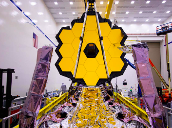
On December 25, 2021, the James Webb Space Telescope was launched into space. The telescope’s main focus was to study “every phase in the history of our Universe, ranging from the first luminous glows after the Big Bang, to the formation of solar systems capable of supporting life on planets like Earth” (McQuilkin, Chakrabarti, Skoog 2023). The telescope is a huge feat for space exploration and understanding what is beyond our solar system. JWST has brought back information on the birthplace and death of stars, the emergence of galaxies, and even an understanding of the Big Bang. What if we could apply something similar to archaeology?
Advanced satellites have similar impacts on archaeology as well, in that they help advance the field’s knowledge of the past. Egyptologist, Dr. Sarah Parcak, utilizes satellite imaging in her daily work life. The infrared technology was able to pick up signatures of different densities of minerals and material in archaeology sites. In Egypt alone, the satellite found “17 new ‘possible’ pyramids, 1,000 new tombs, and 3,000 new sites in total”(Space Satellite Archaeology). This technology is a huge step forward for archaeology. Using this method, archaeologists can now identify sites that wouldn’t have been previously known to the naked eye. Dr. Parcak herself was able to identify hundreds of archaeological digs in Egypt.
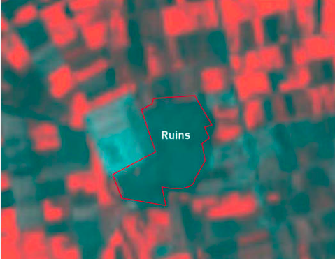
The ancient city of Ubar in a section of the country of Oman called Rub’al Khali, was discovered mainly by using satellite imaging. The archaeologists on site found information about the climate of the city, and an eight-sided structure was revealed, even the cause of the city’s fall. Researchers determined that the city quite literally fell to its abandonment. The city’s center was unknowingly built on a limestone cavern, and when the weight of it all became too much, everything fell into a massive sinkhole.
Continuing to use the satellite images, researchers were able to decipher trade routes that “were packed down into hard surfaces by the passage of hundreds of thousands of camels”(Maugh II 1992). The team of researchers deduced that the city of Ubar was a city of tent dwellers excluding the center keep was a stone fortress. Thought to be the living quarters of the monarch, the fortress “was ringed by eight walls, each about two feet thick, 10 to 12 feet high and about 60 feet long”(Maugh II 1992).
Works Cited:
McQuilkin, Hilary, Meghna Chakrabarti, and Tim Skoog. “A Year of Discovery from the James Webb Space Telescope.” On Point, July 19, 2023. https://www.wbur.org/onpoint/2023/07/19/a-year-of-discovery-from-the-james-webb-space-telescope.
Research Outreach. “Archaeology from Space: Using Earth Observation Data to Unearth Our Past.” Research Outreach, November 8, 2023. https://researchoutreach.org/articles/archaeology-space-using-earth-observation-data-unearth-past/#:~:text=By%20using%20images%20and%20data,sites%20remain%20as%2Dyet%20undiscovered.
“Satellite Imagery in Archaeology and Cultural Heritage Preservation.” Utilities One. Accessed December 3, 2023. https://utilitiesone.com/satellite-imagery-in-archaeology-and-cultural-heritage-preservation.
“Space Satellite Archaeology.” Space Satellite Archaeology – NASA satellite imaging – infrared. Accessed December 3, 2023. https://www.age-of-the-sage.org/space_archaeology/space_satellite_archaeology.html.
“Ubar, Fabled Lost City, Found by L.A. Team : Archeology: NASA Aided in Finding the Ancient Arab Town, Once the Center of Frankincense Trade.” Los Angeles Times, February 5, 1992. https://www.latimes.com/archives/la-xpm-1992-02-05-mn-1192-story.html.
Images Used:
Further Readings:
What are some known limitations and challenges of applying satellite imaging to archaeology? Would these be resolvable if complemented by other techniques?