
Advancements in satellite imagery like Google Earth revolutionized archaeology in terms of its user-friendly interface, accessibility, and monitoring capabilities in the face of the rising looting crisis.
Prior to Google Earth’s release to the public, three-dimensional imaging was costly, inefficient, and convoluted. In 2005, Google Earth revolutionized imaging: it was free to download, interactive, and visualized the entire planet from a computer screen. Aerial, oblique, and horizontal viewing angles are available with the platform along with “placemarks” that save coordinate locations, making it an important resource to archaeologists for aerial surveying (Ur 2006, 35). While Google Earth does not replace existing resources, it has proven to be a useful tool in data collection for site looting.
Over the past few decades, looting incidents have increased, especially in countries lacking the authoritative figures, resources, and policies to adequately protect archaeological sites (Tapete 2016, 42-43). Without data and scale surrounding looting, archaeologists struggle to advocate for public policy to protect against it because authorities can claim an overestimation of the issue’s severity, and even if a policy was instituted, there is little structure to track the efficacy of any policy made. One method of collecting necessary data to protect against looting is to utilize Google Earth’s affordable imaging system (Contreras 2010, 101). Google Earth can be used in longitudinal studies by collecting images over a period of time and monitoring looting patterns, therefore providing background and context to determine what factors contribute to looting (Contreras 2010, 104).
Research conducted with Google Earth images discovered that 515,351 square meters were looted across archaeological sites in Jordan (see Figure 1), exemplifying the role basic imaging contributes to the field (Contreras 2010, 110). In another case study completed in a site in Apamea, Syria – a site on the World Heritage at Risk list – images analyzed from Google Earth from 2012 and 2014 proved that approximately 38% and 45% of the site was looted, respectively (Tapete 2016, 44). The two case studies highlight the significance of Google Earth as an archaeological tool to examine and quantify looting, a crucial step toward preventing and managing the crisis (Figure 2). By creating a key as in Figure 2, new looting marks, repeated looting sites, and clusters can be identified over a longitudinal study, providing the pertinent data to better formulate policy and protection over sites.
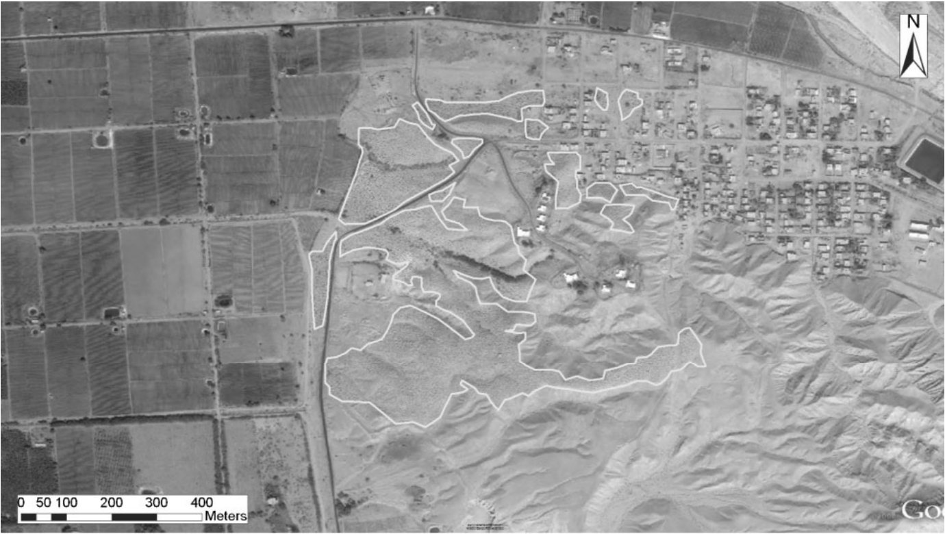
Figure 1. A Google Earth image from 2004 of a site in Safi detailing looting marks. Clusters are denoted by the white lines (Contreras 2010, 112).
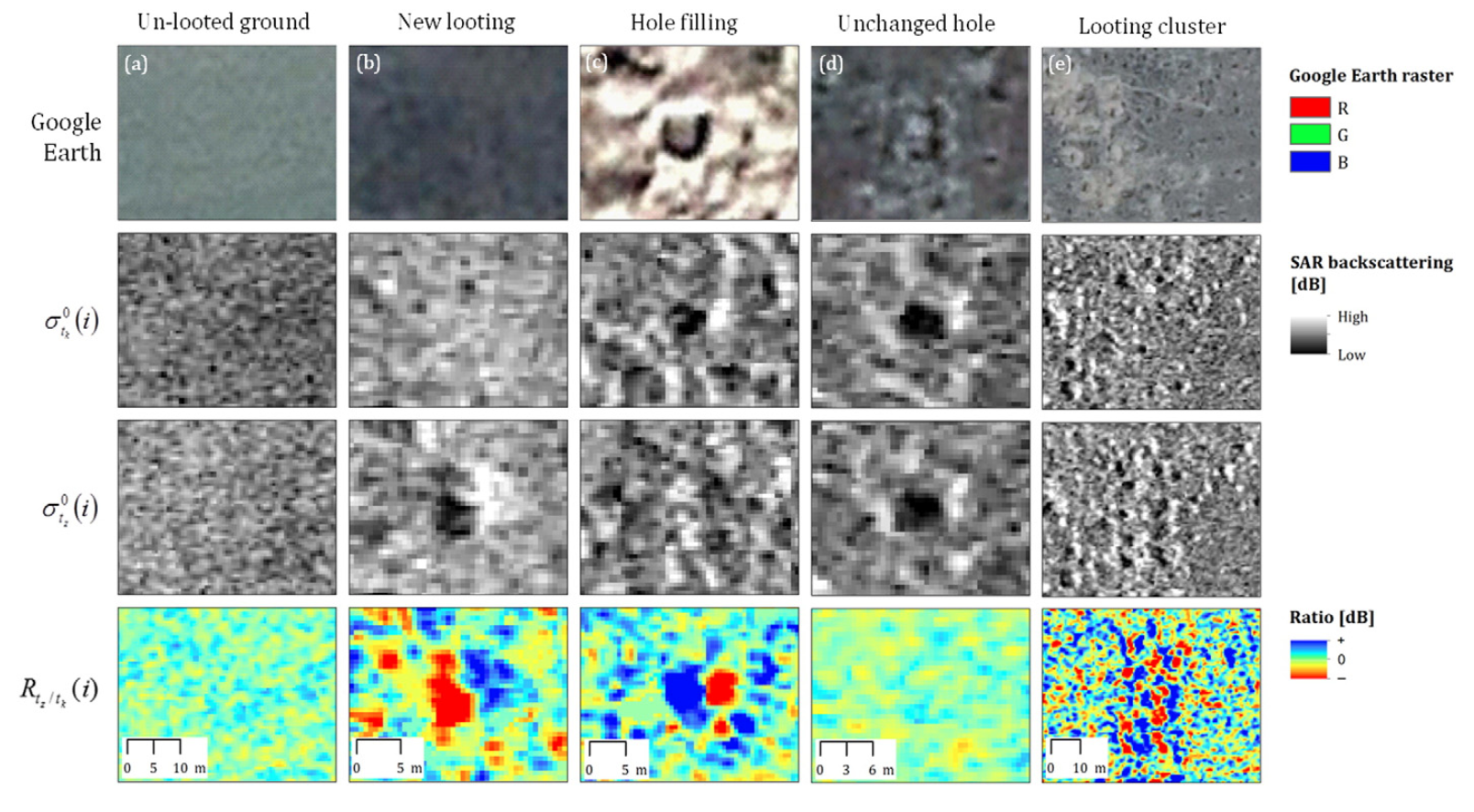
Figure 2. This key demonstrates the use of Google Earth images and other specialized technology to determine looting patterns and occurrences in Apamea, Syria (Tapete 2016, 55).
While Google Earth remains a viable option for aerial survey due to its accessibility, there are constraints to its practicality that cannot replace existing, specialized technology in the archaeological field. There are multiple factors contributing to Google Earth’s image viability: the region must be well-documented with high-resolution photos, atmospheric conditions must be clear, and dry and desert landscapes are preferred (Contreras 2010, 111). Since 2005, Google Earth has been a key development that has propelled aerial surveying techniques to quantify looting, but this data must be applied to better allocate resources and formulate policies to protect these culturally significant sites.
For further information on Google Earth and archaeology:
“How Google Earth Has Revolutionized Archaeology” https://www.discovermagazine.com/the-sciences/how-google-earth-has-revolutionized-archaeology
“Looting at Apamea recorded via Google Earth” https://traffickingculture.org/data/data-google-earth/looting-at-apamea-recorded-via-google-earth/
References:
Contreras, Daniel A., and Neil Brodie. “The Utility of Publicly-Available Satellite Imagery for Investigating Looting of Archaeological Sites in Jordan.” Journal of Field Archaeology 35, no. 1 (March 2010): 101-14. Accessed September 8, 2022. https://doi.org/10.1179/009346910X12707320296838.
Renfrew, Colin, and Paul G. Bahn. Archaeology Essentials: Theories, Methods, Practice with 303 Illustrations. 4th ed. London: Thames & Hudson, 2018.
Tapete, Deodato, Francesca Cigna, and Daniel N.M. Donoghue. “‘Looting Marks’ in Space-borne SAR Imagery: Measuring Rates of Archaeological Looting in Apamea (Syria) with TerraSAR-X Staring Spotlight.” Remote Sensing of Environment 178 (June 2016): 42-58. Accessed September 8, 2022. https://doi.org/10.1016/j.rse.2016.02.055.
Ur, Jason. “Google Earth and Archaeology.” The SAA Archaeological Record 6, no. 3 (May 2006): 35-38. Accessed September 8, 2022. https://tinyurl.com/yczc232l.
How can studying the archaeology of looting help us prevent looting of important sites in the future?