Bodies in the Bog: Revealing Early European Rituals

The lands of northern Europe are peppered with muddy bogs full of decaying life. On the surface, these wetlands seem like nothing more than pools of moss and disease, but underneath lies a real treasure: bog bodies. These bodies have been exceptionally well preserved by this unlikely environment, even down to their last meal. 

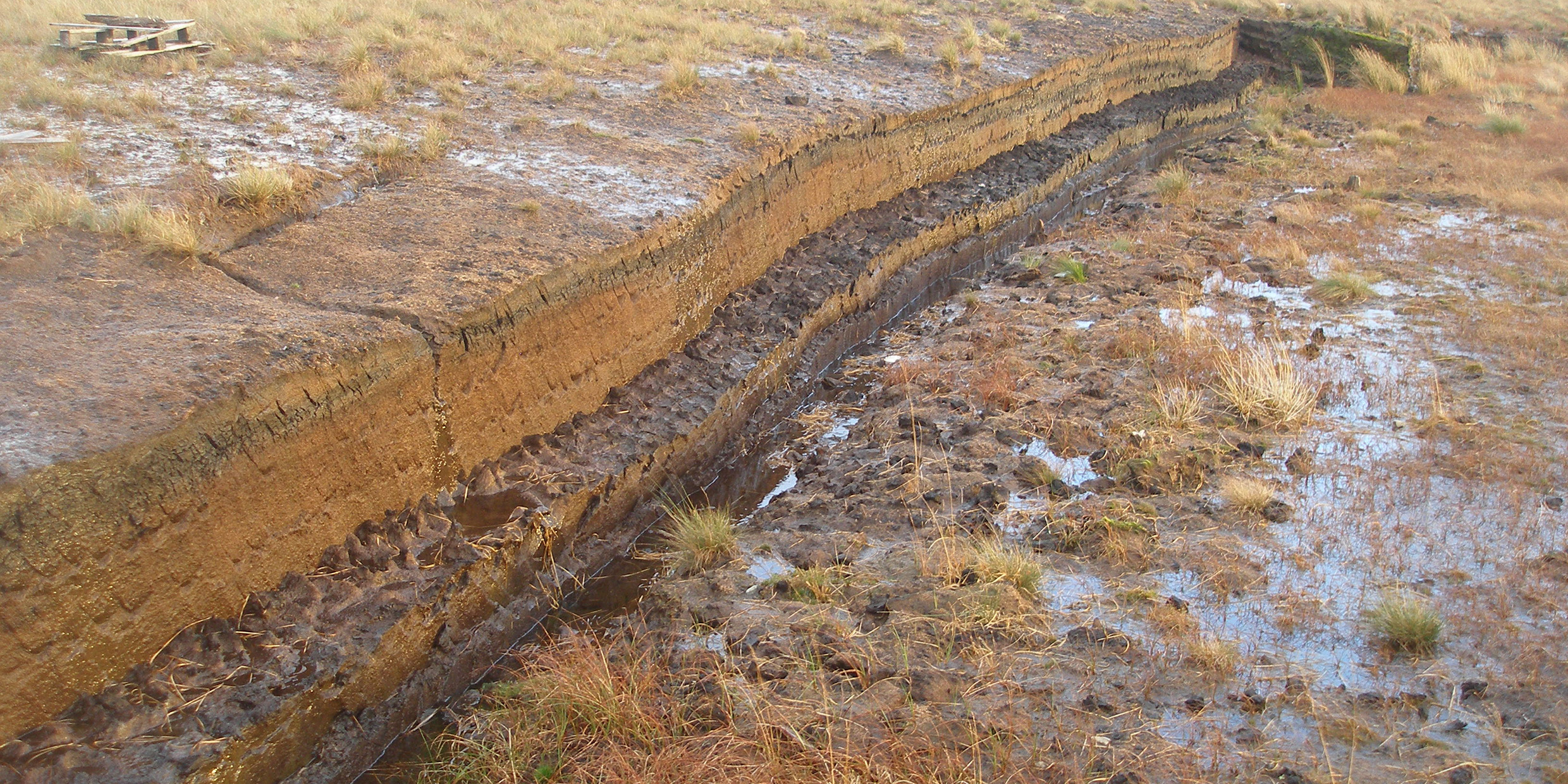
A look at the layers of a peat bog. A body can be trapped and preserved for thousands of years.

So how does this phenomenon occur? The secret to their remarkable preservation is a specific moss called sphagnum. The moss itself creates an insulated dome that prevents most oxygen from filtering through to the land beneath it. Not only that, it acts as a sponge that absorbs calcium and magnesium from its surroundings, resulting in a more acidic environment that is toxic to natural decomposers like bacteria and fungi. Even in death, the moss acts to preserve the bodies by releasing a chemical called Sphagnan that both eliminates bacteria and gives these bog bodies their signature leathery brown/black skin.

These bodies tell tales that bring up a lot of questions for the archaeologists that discover them. Primarily, most of the bodies have telltale marks of violent death, whether through hanging, stabbings, or blunt force trauma. On occasion, the bodies even show multiple fatal wounds, baffling researchers further.

The mummified head of the aforementioned Lindow Man. A notch can be seen where a blunt object fractured his skull.

One of the more significant bodies in this puzzle is the Lindow Man. Discovered by peat cutters in 1984, this corpse was found to be a young man who lived around the 1st century A.D. Researchers identified three different causes of death: he was hit in the head, garroted, then had his throat slit. The discovery of water in his lungs also indicates this wasn’t simply somewhere his body was dumped. He was intentionally killed far out into the bog, though the exact reason for this is unknown.

Some have speculated that these bodies may have been a result of some kind of violent ritual based on cultural beliefs surrounding the bogs. While we may not see bogs are particularly useful today, in the Iron Age, bogs were a vital part of their society. Some professionals theorize that these societies may have believed that the bogs had some connection to the underworld or a higher power, and that ritual death would often occur in bogs as a result. The details of Lindow Man’s last meal (a charred griddle cake) lend credence to this theory as well. An old British ritual has people pull griddlecakes from a bag, with the one that pulled the charred cake put to death. 

As Europe closes down its bogs due to peat harvesting’s adverse effect on climate change, there will certainly be fewer bog bodies to be discovered and investigated. The mystery of the bog bodies might just remain a mystery for a little longer.

Links of Interest

Video Documentary of North American Bog Bodies

Specifics About Lindow Man

References

Magazine, Smithsonian. “Europe’s Famed Bog Bodies Are Starting to Reveal Their Secrets.” Smithsonian.com, Smithsonian Institution, 1 May 2017, www.smithsonianmag.com/science-nature/europe-bog-bodies-reveal-secrets-180962770/.

Mancini, Mark. “Peat Bogs Are Freakishly Good at Preserving Human Remains.” HowStuffWorks Science, HowStuffWorks, 24 Aug. 2022, science.howstuffworks.com/environmental/earth/archaeology/peat-bogs-are-freakishly-good-at-preserving-human-remains.htm.

“The Mystery of the Human Sacrifices Buried in Europe’s Bogs.” BBC Future, BBC, www.bbc.com/future/article/20220907-the-mystery-of-the-human-sacrifices-buried-in-europes-bogs.

Experimental archaeology and its uses

Figure 1: Metal working in the Museo Archeologico Etnologico in Modena. Photo by Andrea Moretti. https://exarc.net/issue-2019-1/ea/experimental-archaeology-who-does-it-what-use

            Experimental archaeology is defined as a sub-field of archaeology research that uses many strategies to imitate past events and attempt to better understand what happened (Paardekooper 2019). While experimental archaeology does have its limits in not working with real artifacts, it does have the unique advantage of attempting to repeat the processes that occurred in the past and gain knowledge through data and experience.

            Traditionally, this sub-field was one of the aspects of archaeology that is conducted scientifically by developing a hypothesis, conducting an experiment, and then analyzing the data to come to a conclusion. However, experimental archaeology has grown and taken on many forms now, such as being used as an outreach program. For example, researchers at the Stonehenge Visitor Center replicated a possible version of the creation of Stonehenge using wooden logs, ropes, simple mechanics, and community participation (Archaeology 2018) (Figure 2). Through this experiment, more questions about the creation of Stonehenge were developed, such as what were the environmental conditions when it was built? Researchers speculated that it could have been done when the ground was dry and hard, or the people may have dug the topsoil off to reach the hard and compact dirt. These hands-on experiences help inform the public of the importance of archaeology, while also bringing forth new research questions.

Figure 2: Imitating possible strategy for moving stones at Stonehenge Visitor Center. Photo by the English Heritage. https://the-past.com/feature/experimental-archaeology-at-stonehenge/

            Another example of experimental archaeology is the Butser Ancient Farm. The goal of this site is to study the agricultural and economic aspects of England during the period of 400 BC to 400 AD (Stone and Planel 1999). To better understand this topic, specific research programs cover different topics, such as experimental earthwork. Experimental earthwork is the study of replicating structures made from soil such as ditches, banks, and canals (Shaw 2007). In this specific study, a set of ditches and banks were recreated to see how they were effected by environmental conditions over intervals of four, seven, and ten years (Shaw 2007). Through this type of study, researchers can further understand how different layers of soil erode and settle over time. This allows them to identify what they are observing at a genuine site. Another benefit when modeling earthworks is understanding how artifacts are preserved in certain soil conditions. Through this work, archaeologists can recognize how much time it takes for certain materials to degrade and how quickly they need to excavate certain sites to preserve artifacts.

            Experimental archaeology has evolved to take on different forms with each having an important purpose. From social outreach programs to scientific studies, experimental archaeology is allowing archaeologists to better understand what they find and show the public the importance of their work.

Links of interest

https://exarc.net/issue-2013-3/ea/living-conditions-and-indoor-air-quality-reconstructed-viking-house

https://www.universiteitleiden.nl/nexus1492/news/start-of-reconstruction-indigenous-village-in-st.-vincent


References

Archaeology, Current. 2018. “Like a Rolling Stone: Experimental Archaeology at

            Stonehenge | The Past.” The Past. June 29, 2018. https://the-

            past.com/feature/experimental-archaeology-at-stonehenge/.

Paardekooper, Roeland. 2019. “Experimental Archaeology: Who Does It, What Is the

            Use?” EXARC Journal, no. EXARC Journal Issue 2019/1 (February).

            https://exarc.net/issue-2019-1/ea/experimental-archaeology-who-does-it-

            what-use.

Shaw, Christine. 2007. “Site Publications.” Butser Ancient Farm Archive. 2007.

           http://www.butser.org.uk/sitepubs.html.

Stone, Edited Peter G, and Phillippe G Planel. 1999. “A Unique Research & Educational

            Establishment,” 10.

The Business of Garbology

Garbology, the study of trash, was created by archaeologist Bill Rathje in the 1970s. Garbology involves examining waste in order to discover patterns about human behavior. These patterns can also be an important business strategy. Companies study waste in order to determine how well their products are doing in comparison to their competitors. 

In the 1970s a popular UK yogurt brand, Ski, started to face major competition. In order to do market research and compare Ski’s sales to their competitors, a garbology study was conducted. The study was done by Audits of Great Britain, through a “dustbin audit.” This meant that households across the UK were paid to put their trash from certain products and brands in a separate trash can. The trash was then collected and cataloged, revealing how often certain products were being purchased. Ski and their competitors were all on the list of products to be separated. The study revealed Ski’s success over the competition. This was a crucial marketing strategy, as it revealed that Ski was outperforming other brands, and allowed for them to negotiate favorable shelf space with grocery stores and other retailers. 

Garbology is also used for corporate espionage. Companies have been involved in elaborate schemes to steal trash from their rivals, all in the hopes of gaining valuable intelligence on their products. One example of this is the 2001 conflict between hair-care companies Proctor & Gamble (P&G) and Unilever. P&G admitted to going through Unilever’s trash in hopes of gathering information. Senior P&G officials were supposedly unaware of the operation and put a stop to it after finding out. This involved handing documents over to Unilever, firing multiple employees involved, and issuing an official apology. This example is one of many where companies have been caught spying. In fact, there are those who have made their careers in the garbology side of corporate espionage. Marc Barry, co-author of Spooked: Corporate Espionage in America, claims to have searched over 2,500 dumpsters throughout his career, but that it is one of the riskiest forms of corporate espionage, because “If one of your agents gets caught, there’s no plausible deniability” (Sachdev 2001). While risky, many companies use garbology as an intelligence strategy because of how much information they can gain on their competitors’ products, making it a surefire way to get ahead. 

The numerous ways in which garbology can be applied to marketing and business strategy demonstrates how valuable of a tool it is. When studying trends of human behavior or advancements in products, trash is an important physical data point. As a business strategy it is a way of studying the market in order to get ahead. There are some ethical concerns with how these strategies may be conducted, and most of them are deemed unprofessional, as they are initiated by one company without the others’ consent. However, these strategies persist, as it is difficult to doubt their business-advancing results. 


Students sorting through trash to be cataloged

Example of a waste/dustbin audit

Further Reading:

History of Garbology:

https://www.starsinsider.com/lifestyle/501073/garbology-the-lessons-we-can-learn-from-peoples-trash?utm_source=rss-lifestyle&utm_medium=rss&utm_campaign=rssfeed 

Garbology and Our Future:

https://www.youtube.com/watch?v=m9qR2_67xaQ 

References

Baraniuk, Chris. 2022. “Garbology: How to spot patterns in people’s waste.” BBC. https://www.bbc.com/future/article/20220429-garbology-how-to-spot-patterns-in-peoples-waste.

Boisvin, Lindsey, and Karen Cheng. 2016. “Animated waste installation | UW Facilities Blog.” UW Facilities. https://facilities.uw.edu/blog/posts/2016/04/18/uw-garbology.

“Garbology – Meaning, Importance & Example.” 2020. MBA Skool. https://www.mbaskool.com/business-concepts/marketing-and-strategy-terms/17878-garbology.html#3.

Logue, Stephen. 2016. “History of Ski.”

Sachdev, Ameet. 2001. “P&G admits Unilever garbage search.” Chicago Tribune. https://www.chicagotribune.com/news/ct-xpm-2001-09-01-0109010181-story.html.

“Waste Audit – Getting Started – Reductioninmotion.com.” 2022. Reduction In Motion. https://reductioninmotion.com/waste-consulting/waste-audit/.


Ozette Site: The Whaling Village Rediscovered Under a Blanket of Mud

By: Aidan Wisherd

Preservation of artifacts can be in a plethora of forms. For the Ozette Site in the Pacific Northwest, mud encased the whaling village dating back to 1700 CE (Renfrew 2018, 58). The Makah tribe’s tremendous history was revealed around 1970 following a weather event in Washington that began to reveal artifacts from the nearly 2000 year old whaling village (Renfrew 2018, 58). Ozette displayed past environmental and natural events, along with a deep history of the people that lived on the land. 

Figure 1. Rocks surrounding the excavation site display carvings dating back to before the mudslide of the Ozette Site in 1700 CE (Sainsbury 2022)

Ozette brings to light many key archaeological lessons to take as the examination of further Indigenous sites continues. Washington State University had been examining archaeological sites near the Makah’s land since the 1940s, but their breakthrough 20 years later was incomparable (Washington State University 2022). Richard Daugherty, an archaeologist from Washington State at the heart of the excavation and examination of the site for 11 years, prioritized a close relationship with the Makah (Washington State University 2022). This was to ensure both respect and care were taken with preserving and eventually displaying the tribe’s history. The way the artifacts were preserved must also be viewed. Mud worked to encase the history of the whaling village with six cedar houses and tens of thousands of artifacts (Sainsbury 2022). Wet clay surrounded the pieces of the thriving whaling village and acted as a sealant, keeping out air and protecting the pieces from erosion.

Figure 2. Richard Daugherty carefully examines one of the most important artifacts recovered from Ozette, a wood carving of a Whale’s fin (Washington State University 2022)

Crucial to the excavation in Washington was the relationship with the Indigenous peoples of the land. The Makah assisted Daugherty with the cultural context of many pieces that the team could not initially understand (Knight 2015). The relationship between the team and tribe went both ways, with Daugherty and his team working to not only preserve history but to help the Makah find what they previously thought to be lost. From the outset, the tribe was determined to display their artifacts on their land for generations beyond them to see (Sainsbury 2022). In this vein, around 500 pieces are currently on display within a museum that remains on Makah land and serves the local community and those that choose to visit (Sainsbury 2022). 

From the excavation of the site and the initial discovery, Ozette teaches us about how archaeology can teach and preserve. Approaching the site in a way that serves the Makah is important for archaeologists to mirror. It must be understood that the work is community-focused, rather than for name recognition associated with a dig or discovery.


Some pieces to view for further discovery:

Ozette: The US’ lost 2,000-year-old village

Makah Museum: Ozette Archaeological Site

———————————————————————————————————

References

Knight, Alexa. 2015. “Discoveries at Ozette.” Northwest Coastal Native Americans. May 28, 2015. https://nwcoastindians.wordpress.com/2015/05/28/discoveries-at-ozette/. 

“Ozette: The US’ Lost 2,000-Year-Old Village.” 2022. CAS in the Media . Washington State University. June 15, 2022. https://cas.wsu.edu/news/2022/06/15/ozette-the-us-lost-2000-year-old-village/. 

Renfrew, Colin, and Paul Bahn. 2018. Archaeology Essentials: Theories, Methods, and Practice. Fourth edition. Thames & Hudson.

Sainsbury, Brendan. 2022. “Ozette: The US’ Lost 2,000-Year-Old Village.” BBC Travel. BBC. June 6, 2022. https://www.bbc.com/travel/article/20220605-ozette-the-us-lost-2000-year-old-village. 

How Satellite Imagery and Crowd-Sourcing Can Revolutionize Archaeology

In 2016, seasoned archaeologist Sarah Parcak stood and spoke at the annual TED Conference in Banff, Canada, announcing the fully-funded launch of the first-ever crowd-sourced archaeological program. Dr. Parcak’s vision for this project was to allow the masses to play a role in archaeological site survey and research, which would expedite the path to archaeological discovery and preserve cultural heritage for many.

Aiming to publicize archaeology by seeking the service of thousands of “citizen scientists,” Parcak hoped to fully revolutionize the modern field of archaeological study. This envisioned revolution would build a larger network of archaeological data, drawing public attention to the need for archaeological discovery, and prioritizing the preservation of archaeological sites from threats such as looting (GlobalXplorer 2019). But Parcak’s ambitious plan was not without a fundamental method for archaeological survey: aerial satellite imaging.

Using high-quality aerial imagery provided by DigitalGlobe, thousands of randomly selected satellite images would be uploaded onto the GlobalXplorer portal and made available for volunteer participants to analyze (GlobalXplorer 2018). Learning how to spot potential archaeological sites as well as signs of looting, these suitingly-named “Xplorers” would be trained in video courses provided by the GlobalXplorer team (Hersher 2017).

The participants would next be shown a series of 300-by-300-meter satellite image tiles that they could then identify as a potential archaeological site or looted site (see Figure 1) (GlobalXplorer 2018). As these pictures would be filtered through tens of thousands of trained volunteers, images with the most positive feedback would be marked for trained specialists, such as Sarah Parcak herself, to analyze and further investigate (GlobalXplorer 2018). While the location of sites with confirmed looting activity could be forwarded to local government authorities, GlobalXplorer’s team of archaeologists could determine whether a potential site was ready for physical survey and documentation by partner local archaeologists (GlobalXplorer 2018). With as much manpower as it exhibits, GlobalXplorer is able to fully map large portions of entire countries, as they did Peru by analyzing 14 million total individual tiles in preparation for their first expedition (GlobalXplorer 2018).

Figure 1. The GlobalXplorer platform showing the crowd-sourced site identification program. Photo by GlobalXplorer Platform.

In total, Xplorers from around the world helped locate over 19,000 sites of archaeological interest in Peru, of which roughly 40 high-interest sites were selected for a ground-truthing expedition carried out by local archaeological and geological experts (GlobalXplorer 2018). The captured data would then be turned over to Peruvian authorities to allow the sites to be registered under the protection of the state (GlobalXplorer 2018). During their expedition, on-ground experts recorded what they believed to be undocumented geoglyphs (see Figure 2) related to Peru’s renowned Nasca lines (GlobalXplorer 2018).

Figure 2. Drone Image of geoglyphs in Peru identified by GlobalXplorer’s crowd. Photo by Luis Jaime Castillo Butters.

The successes in Peru are merely a glimpse of what the archaeological world can achieve when pairing a wealth of geographical data provided by satellite imagery with masses of individuals who see the value in locating and protecting sites of archaeological and even cultural significance. With further development of these opportunities and global networks, archaeology can be improved to better protect the sites that hold importance throughout local communities as well as the world.

For more information on GlobalXplorer, or to get involved when GlobalXplorer plans its next expedition, visit:

https://medium.com/@globalxplorer

https://www.globalxplorer.org

References:

GlobalXplorer. “About the GlobalXplorer° Project.” GlobalXplorer. Last modified 2019. Accessed September 11, 2022. https://www.globalxplorer.org/about.

GlobalXplorer. “GlobalXplorer° Completes Its First Expedition: What the Crowd Found in Peru.” Medium. Last modified April 10, 2018. Accessed September 11, 2022. https://medium.com/@globalxplorer/globalxplorer-completes-its-first-expedition-what-the-crowd-found-in-peru-7897ed78ce05.

GlobalXplorer. “Welcome to GlobalXplorerº!” Medium. Last modified April 3, 2018. Accessed September 11, 2022. https://medium.com/@globalxplorer/welcome-to-globalxplorer-7bfb555260a1.

Hersher, Rebecca. “Space Archaeologist Wants Citizen Scientists To Identify Archaeological Looting.” NPR. Last modified January 31, 2017. Accessed September 11, 2022. https://www.npr.org/sections/thetwo-way/2017/01/31/512661370/space-archaeologist-wants-citizen-scientists-to-identify-archaeological-looting.

Google Earth and Its Role in Monitoring the Looting of Archaeological Sites

Advancements in satellite imagery like Google Earth revolutionized archaeology in terms of its user-friendly interface, accessibility, and monitoring capabilities in the face of the rising looting crisis. 

Prior to Google Earth’s release to the public, three-dimensional imaging was costly, inefficient, and convoluted. In 2005, Google Earth revolutionized imaging: it was free to download, interactive, and visualized the entire planet from a computer screen. Aerial, oblique, and horizontal viewing angles are available with the platform along with “placemarks” that save coordinate locations, making it an important resource to archaeologists for aerial surveying (Ur 2006, 35). While Google Earth does not replace existing resources, it has proven to be a useful tool in data collection for site looting. 

Over the past few decades, looting incidents have increased, especially in countries lacking the authoritative figures, resources, and policies to adequately protect archaeological sites (Tapete 2016, 42-43). Without data and scale surrounding looting, archaeologists struggle to advocate for public policy to protect against it because authorities can claim an overestimation of the issue’s severity, and even if a policy was instituted, there is little structure to track the efficacy of any policy made. One method of collecting necessary data to protect against looting is to utilize Google Earth’s affordable imaging system (Contreras 2010, 101). Google Earth can be used in longitudinal studies by collecting images over a period of time and monitoring looting patterns, therefore providing background and context to determine what factors contribute to looting (Contreras 2010, 104).

Research conducted with Google Earth images discovered that 515,351 square meters were looted across archaeological sites in Jordan (see Figure 1), exemplifying the role basic imaging contributes to the field (Contreras 2010, 110). In another case study completed in a site in Apamea, Syria – a site on the World Heritage at Risk list – images analyzed from Google Earth from 2012 and 2014 proved that approximately 38% and 45% of the site was looted, respectively (Tapete 2016, 44). The two case studies highlight the significance of Google Earth as an archaeological tool to examine and quantify looting, a crucial step toward preventing and managing the crisis (Figure 2). By creating a key as in Figure 2, new looting marks, repeated looting sites, and clusters can be identified over a longitudinal study, providing the pertinent data to better formulate policy and protection over sites.

Figure 1. A Google Earth image from 2004 of a site in Safi detailing looting marks. Clusters are denoted by the white lines (Contreras 2010, 112).

Figure 2. This key demonstrates the use of Google Earth images and other specialized technology to determine looting patterns and occurrences in Apamea, Syria (Tapete 2016, 55).

While Google Earth remains a viable option for aerial survey due to its accessibility, there are constraints to its practicality that cannot replace existing, specialized technology in the archaeological field. There are multiple factors contributing to Google Earth’s image viability: the region must be well-documented with high-resolution photos, atmospheric conditions must be clear, and dry and desert landscapes are preferred (Contreras 2010, 111). Since 2005, Google Earth has been a key development that has propelled aerial surveying techniques to quantify looting, but this data must be applied to better allocate resources and formulate policies to protect these culturally significant sites.   

For further information on Google Earth and archaeology:

“How Google Earth Has Revolutionized Archaeology” https://www.discovermagazine.com/the-sciences/how-google-earth-has-revolutionized-archaeology

“Looting at Apamea recorded via Google Earth” https://traffickingculture.org/data/data-google-earth/looting-at-apamea-recorded-via-google-earth/

References:

Contreras, Daniel A., and Neil Brodie. “The Utility of Publicly-Available Satellite Imagery for Investigating Looting of Archaeological Sites in Jordan.” Journal of Field Archaeology 35, no. 1 (March 2010): 101-14. Accessed September 8, 2022. https://doi.org/10.1179/009346910X12707320296838.

Renfrew, Colin, and Paul G. Bahn. Archaeology Essentials: Theories, Methods, Practice with 303 Illustrations. 4th ed. London: Thames & Hudson, 2018.

Tapete, Deodato, Francesca Cigna, and Daniel N.M. Donoghue. “‘Looting Marks’ in Space-borne SAR Imagery: Measuring Rates of Archaeological Looting in Apamea (Syria) with TerraSAR-X Staring Spotlight.” Remote Sensing of Environment 178 (June 2016): 42-58. Accessed September 8, 2022. https://doi.org/10.1016/j.rse.2016.02.055.

Ur, Jason. “Google Earth and Archaeology.” The SAA Archaeological Record 6, no. 3 (May 2006): 35-38. Accessed September 8, 2022. https://tinyurl.com/yczc232l.

Applying Lidar Technology in Archaeology of Pre-Hispanic Latin America

Lidar is a remote sensing technology that allows archaeologists to gain a better understanding of the geographical features in an area without surveying on the ground. It is utilized by pulsing lasers from a plane or drone down to the earth, and registering the time they take to return (US Department of Commerce, NOAA 2019). This data, combined with information from GPS, can generate an extremely accurate and precise topographic model of the area. It is especially useful because it is able to see through the treeline to the forest floor, which is vital in dense forested areas that would otherwise be difficult to ground survey or analyze through satellite imagery (Renfrew and Bahn 2018).

One region where the technology has been applied with great success is South and Central America. These regions have sections of extremely dense forest, as well as very little information recorded about pre-Hispanic societies, forcing archaeologists and historians to take different approaches to information gathering. While some societies, like the Inca and Maya, are the subject of a decent amount of recorded knowledge, in most other less established societies there is very little documentation. Lidar has proved to be extremely useful in discovering more about societal organization, agriculture, and infrastructure in lesser-studied parts of South and Central America. 


Figure 1. Map of lidar-analyzed site with outlines known and possible features picked up by lidar. Map created by Rivera-Collazo et al., 2021. 

Researchers have celebrated the role of lidar in the examination of thus far under-studied areas in Latin America. One group used lidar imaging to examine areas of Puerto Rico for ancient indigenous architecture. While there is limited lidar data for the Caribbean, open-access datasets revealed large-scale architectural planning, including plazas, paths, and possible agricultural areas. The authors discuss the helpfulness of lidar for this area in particular, which is densely forested and therefore difficult to access by ground survey or satellite imagery (Rivera-Collazo, Rodríguez-Delgado, and Rodríguez-Miranda 2021). This research reinforces the need for more lidar coverage in forested areas of the world, as it provides archaeological information that is not readily available in other forms. Another researcher discussed the use of lidar in the Bolivian Amazon, a region where researchers previously had known very little about pre-Hispanic societies. It was used to penetrate the treeline and two pre-hispanic low-density urban sites were discovered (Prümers et al. 2022). This type of society is harder for researchers to investigate because of a lack of written documents and permanent infrastructure, but the use of lidar can enhance search efforts. 

Figure 2. Topographical map created by lidar of the site Cotoca, a large settlement found in the Bolivian Amazon. Map created by Prümers et al. 2022. 

Many researchers in South and Central America support the use of lidar to discover more about Latin American pre-hispanic societies. The frequency of dense forests in these regions combined with the lack of comprehensive records of Indigenous societies and activities pre-colonialism makes it an excellent candidate for the use of lidar technology for initial archaeological survey. Lidar still requires corroboration, however, so it is not a replacement of fieldwork, but it can be used to narrow down sites for ground survey and excavation.

Works Cited

Prümers, Heiko, Carla Jaimes Betancourt, José Iriarte, Mark Robinson, and Martin Schaich. 2022. “Lidar Reveals Pre-Hispanic Low-Density Urbanism in the Bolivian Amazon.” Nature 606 (7913): 325–28. https://doi.org/10.1038/s41586-022-04780-4.

Renfrew, Colin, and Paul G Bahn. 2018. Archaeology Essentials : Theories, Methods, Practice with 303 Illustrations. London: Thames & Hudson Ltd.

Rivera-Collazo, Isabel, Eric Rodríguez-Delgado, and Marisol Rodríguez-Miranda. 2021. “Lidar Inspection for Indigenous Architecture at Caguana Ceremonial Complex, Borikén.” Latin American Antiquity 33 (1): 205–11. https://doi.org/10.1017/laq.2021.86.

US Department of Commerce, National Oceanic and Atmospheric Administration. 2019. “What Is LIDAR?” Noaa.gov. 2019. https://oceanservice.noaa.gov/facts/lidar.html.

Further Reading: 

Lost cities of the Amazon discovered from the air; https://www.smithsonianmag.com/science-nature/lost-cities-of-the-amazon-discovered-from-the-air-180980142/

Lidar reveals oldest and biggest Maya structure yet found; https://www.sciencenews.org/article/lidar-reveals-oldest-biggest-ancient-maya-structure-found-mexico

Dynamic Nature of the Archaeological Approach

The progression of archaeological practices as shown by the study of the Tolland Man.

In 1950, farmers Viggo and Emil Hojgaard were spading through a peat bog near the town of Tollund in Denmark. The pair found a well-preserved body laying in a sleeping position in the bog (Figure 1). The body had a rope wrapped tightly around his neck and a cap on his head (Levine, 2017). Now known as the Tollund Man, the incredible preservation of his skin, hair, and organs give the opportunity for archaeologists to look into his life from 2,300 years ago.


Figure 1. Tollund Man after excavation (Levine, 2017).

The Tollund Man is one of many bodies found in peat bogs across Europe. These bogs stood out from Europe’s dense forests as one of the few places where the entire area from water to sky was exposed. The acidic bogs have little oxygen and an abundance of sphagnum moss. When the moss dies, it releases a chemical that binds to nitrogen, preventing the growth of bacteria that could break down the body. The sphagnum extracts calcium from bones, which is why the flesh of bog bodies is better preserved (Levine 2017).

Because of the unique nature of the preservation of these bodies, bog bodies are a wealth of archaeological information, as tests like microCT scans of his arteries are performed on body parts that are not usually preserved (Levine, 2017). The Tollund Man has been tested and retested since his discovery in 1950, offering an insight into how archaeology methods have changed throughout the years.

The handling of the body initially showed use of the culture history approach to archaeology. In the 1960s, scientists started to use processual archaeology. Culture history focuses on when and where artifacts were found (Renfrew 2018, 25), whereas processual archaeology uses science to ask questions that connect the artifact to its place in a complex culture (Renfrew 2018, 28). The initial cataloging of the Tollund Man falls under a culture history approach, while later testing shows the progression into processual archaeology.

Testing right after the discovery consisted of an x-ray to the body and head, and an autopsy. Instead of using archaeology specific methods that took into consideration the age and fragility of the body, researchers used similar techniques to an autopsy of a modern body, possibly disrupting his preservation (Levine, 2017). The intestines were briefly removed and examined, but an in depth study of the contents of his stomach would not occur until later (Nielsen et al. 2021). Notably, researchers found both barley and flax, which grow in different seasons (Figure 2). The use of a processual archaeology lens revealed evidence of food storage 2,300 years ago, a find that the brevity of a culture history approach might have missed.

Figure 2. Tollund Man’s last meal (Nielsen 2021).

Moving past the culture history approach of collecting and dating artifacts has allowed archaeologists to study the larger culture surrounding the Tollund Man and bog bodies.

Further Reading:

Article:

“Why Did the Tollund Man Have to Die?”

https://www.museumsilkeborg.dk/why-did-tollund-man-have-to-die 

Poem:

“The Tollund Man”

https://www.poetryinternational.com/en/poets-poems/poems/poem/103-23607_THE-TOLLUND-MAN

Podcast:

Discovery of the Tollund Man- Episode 128

https://www.archaeologypodcastnetwork.com/arch365/128


References

Djinis, Elizabeth. “Last Meal of Sacrificial Bog Body Was Surprisingly Unsurprising, 

Researchers Say.” History. National Geographic, July 21, 2021. https://www.nationalgeographic.com/history/article/tollund-mans-last-meal. 

Levine, Joshua. “Europe’s Famed Bog Bodies Are Starting to Reveal Their Secrets.” 

Smithsonian Magazine. Smithsonian Institution, May 1, 2017. https://www.smithsonianmag.com/science-nature/europe-bog-bodies-reveal-secrets-180962770/.

Nielsen, Nina H., Peter Steen Henriksen, Morten Fischer Mortensen, Renée Enevold, 

Martin N. Mortensen, Carsten Scavenius, and Jan J. Enghild. “The Last Meal of Tollund Man: New Analyses of His Gut Content.” Antiquity 95, no. 383 (2021): 1195–1212. doi:10.15184/aqy.2021.98.

Renfrew, Colin, and Paul Bahn. 2018. Archaeology Essentials: Theories, Methods, and 

Practice. Fourth edition. Thames & Hudson.


Image Credits

Tollund Man after excavation [online image]. Photograph by Christian Als, Smithsonian Institute.

https://www.smithsonianmag.com/science-nature/europe-bog-bodies-reveal-secrets-180962770/

Tollund Man’s last meal [online image]. Photograph by P.S. Henriksen, the Danish National Museum.

https://www.cambridge.org/core/journals/antiquity/article/last-meal-of-tollund-man-new-analyses-of-his-gut-content/E79FB52BAEF8B59BE2280F182C76DEBF

How digital analysis tools can change the scope of modern archaeology

Figure 2: Confiscated toy cars at Border Patrol in Arizona, photo by Tom Keifer 2016

Figure 1: Confiscated wallets at Border Patrol in Arizona, photo by Tom Keifer 2013

Digital records have become more thorough and mainstream. Algorithms know more about human activity than anything else. This combined with the fact that technology and media are so accessible to the public creates what could be seen as a new kind of archeological site: the online version. Mr. Keifer, a janitor who worked in the Customs and Border Protection Agency in Arizona, documented confiscated items from migrants to categorize and photograph them. His process of documenting artifacts considered prized possessions by the people who carried them and putting it online through a digital medium like photography got so popular that it got a feature in the New York Times. This is key to understanding how the digitization of archeology could grow into an effective way to analyze human patterns and behavior in the past and present.

All the criticism surrounding social media platforms for their use of algorithms and data usage makes it easy to discredit how these tools can aid scientific discoveries. Additionally, these algorithms prove how important user interaction is. Science has evolved through technology and in how it appeals to the now well informed public. This data from social media platforms allows the observation of human social activity, specifically revolving around topics like archeological sites, monuments, timelines, communities, and other discourses in individual and collective experience. (Richardson, L.-J, 2019) It lets people like Mr. Keifer find people who share either a collective connection to what this series depicts or who feel an individual desire to learn more; especially with a platform like the New York Times whose influence spans worldwide. 

Another aspect of media archaeology itself that is used to examine human behavior is composition and the creation of narration. When putting together a piece of art, an article, or a piece of code, the person behind it has a very intentional vision. “those working in commercial areas of digital media, such as computer games, construct systems that operationalize ideas of narrative structure, character behavior, linguistic interaction, and so on.” (Erkki Huhtamo and Jussi Parikka 2011,320) There is an “underlying logic” to each of these intentional programs. In the photographs by Mr. Keifer, the visual aesthetic choices he made when putting these artifacts together renews their usage when they belonged to the original owners, and draws in an audience to unknowingly examine and analyze a digital archeological site. The photograph with the wallets (Figure 1) is methodical and organized. The wallets are similar in color scheme which is reflected in the background chosen. They form a grid; showing they are similar enough to be grouped together, but different enough to stand out as their own artifact. A wallet conveys organization and style which comes through in the image itself. The same process can be applied to Figure 2 where colorful toy cars, which evoke innocence and childhood, are placed not in a grid but in a play formation as if a child had just left them there. Although media archeology covers pre-digital media as well, the present day digital systems really allow archeologists to analyze multiple variables at once. The massive amount of thought that goes into the creation of what we could now consider artifacts allows the archeologists to have access to the artifact itself and the information surrounding the potential thought process behind its creation; especially in the digital form.


REFERENCE LIST:

Richardson, Lorna-Jane. 2019. “Using Social Media as a Source for Understanding Public Perceptions of Archaeology: Research Challenges and Methodological Pitfalls.” Journal of Computer Applications in Archaeology 2(1), 151–162.

Huhtamo, Erkki, Jussi Parikka. 2011.Media archaeology : approaches, applications, and implications.Berkeley and Los Angeles, California:University of California Press.

BIBLIOGRAPHY:

https://journal.caa-international.org/articles/10.5334/jcaa.39/#

http://s3.amazonaws.com/arena-attachments/1181527/572f596a6d1ff400d0a1982c2e044d0c.pdf?1502198877

Death: The End?

Death is a universal experience, yet the way we mourn and remember our dead can vary drastically from culture to culture. In some societies, elaborate funerary rites and ceremonies are performed in order to send the deceased off into the afterlife, while in others, the body is simply buried or cremated with little fanfare.

One of the ways that archaeologists can learn about how a particular culture remembered and honored its dead is by studying the funerary objects found in burial sites. These objects range from simple items like pottery sherds or stone tools to elaborate offerings like jewelry, weapons, or games (Figure 1). By analyzing the funerary objects found in a burial site, archaeologists can gain insights into the beliefs and practices of a culture surrounding death and the afterlife (Ucko 1969).

For example, the ancient Egyptians believed that the afterlife was a continuation of this life, so they placed great importance on funerary objects. Everything from how the body was prepared for mummification to the objects placed in the tomb was designed to help the deceased reach and enjoy the afterlife (Canadian Museum of History 2019).

Figure 1. Gameboard and Gaming Pieces, ca. 1550–1295 B.C. Egyptian. (MET 2022)

Sometimes the objects are status symbols, like a wealthy person’s gold rings or a leader’s sword (Figure 2). Other times they are more personal, like a child’s favorite toy (Figure 3) or a loved one’s image (DeMarrais, Castillo, and Earle 1996).

Figure 2. Burial Weapons dating to the late Iron Age/ early Roman period (1st century B.C.–A.D. 50. Discovered in a grave at Walberton, England. (UCL 2020)

Figure 3. Horse-shaped toy on wheels, ca. 900-800 B.C. Discovered at the cemetery of Lefkandi, Greece. (Odysseus 2007)

In other cultures, funerary objects served a more practical purpose. For example, in Jewish culture, it is believed that the soul of the deceased can not rest unless their body is properly cared for. This means that providing the deceased with a washing and purification ritual known as “Tahara” is of the utmost importance (PBS 2013).

No matter what their purpose, funerary objects offer a window into the complex and fascinating ways that different cultures dealt with death. By studying these objects, we can learn about the people who created and used them and gain a better understanding of our shared humanity.


For more information surrounding death and anthropology, please visit:


References:

  1. Canadian Museum of History. 2019. “Egyptian Civilization – Religion – Life after Death.” Historymuseum.ca. 2019. https://www.historymuseum.ca/cmc/exhibitions/civil/egypt/egcr04e.html.
  2. DeMarrais, Elizabeth, Luis Jaime Castillo, and Timothy Earle. 1996. “Ideology, Materialization, and Power Strategies.” Current Anthropology 37 (1): 15–31. https://www.jstor.org/stable/2744153.
  3. MET. 2022. “Gameboard and Gaming Pieces.” Metmuseum.org. 2022. https://www.metmuseum.org/art/collection/search/544775.
  4. Odysseus. 2007. “Ministry of Culture and Sports | Archaeological Museum of Eretria.” Odysseus.culture.gr. 2007. http://odysseus.culture.gr/h/4/eh430.jsp?obj_id=9352.
  5. PBS. 2013. “February 6, 2004 ~ Jewish Burial Practices | February 6, 2004 | Religion & Ethics NewsWeekly | PBS.” Religion & Ethics NewsWeekly. May 10, 2013. https://www.pbs.org/wnet/religionandethics/2004/02/06/february-6-2004-jewish-burial-practices/1794/.
  6. Ruggeri, Amanda. 2022. “The Mystery Ancient Toys Puzzling Archaeologists.” Www.bbc.com. August 16, 2022. https://www.bbc.com/future/article/20220816-the-worlds-oldest-toys-what-toys-were-used-in-the-past.
  7. Ucko, Peter J. 1969. “Ethnography and Archaeological Interpretation of Funerary Remains.” World Archaeology 1 (2): 262–80. https://www.jstor.org/stable/123966.
  8. UCL. 2020. “The Walberton ‘Warrior.’” Archaeology South-East. March 11, 2020. https://www.ucl.ac.uk/archaeology-south-east/news/2020/mar/walberton-warrior.
  9. Viajonarios. 2019. “Atenas: O Histórico Cemitério Kerameikos E Museu Arqueológico.” Viajonários. January 26, 2019. https://viajonarios.com/en/cemetery-kerameikos/?amp.