Aerial Footage of the Casperkill Creek

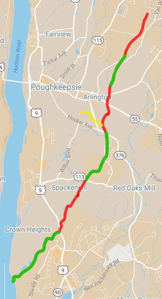
In support of the Environmental Studies focus on the Casperkill Watershed, we recorded a flight above the Casperkill Creek, from its source to its mouth in the Hudson River, a distance of about 10 miles. The course was covered by 6 separate flights, as shown below. We also flew a course over the Casperkill’s biggest tributary, the Fonteyn Kill.

Click on a red or green line segment to see a drone video of the corresponding section of the Casperkill Creek, flown north to south, or click here to see all 6 segments in succession. (Click on the yellow line segment to see a drone video of the Fonteyn Kill.)

Casperkill section 1 Casperkill section 2 Casperkill section 3 Casperkill section 4 Casperkill section 5 Casperkill section 6 Fonteyn Kill
Share

Main Campus Orthomosaic

The VSA organization Vassar Urban Enrichment asked us to create an aerial image of the entire main campus (i.e. not including the Vassar Farm, Townhouses, golf course, etc.) After a few tries with the ACS drone, we determined that the wifi signal it uses to communicate with its controller was insufficient for handling the distance we needed and the occasional obstacles in between. Drone pilot Chad Fust then used his own drone, which uses an RF signal, rather than wifi, and we were able to complete the project in two sections. The result is a merge (“orthomosaic”) of about 900 individual photos.


(Link to website)

Share

Puzzle Pieces

We recently used the drone for a fun project: getting an aerial photo of a large sculpture project. Sculpture student Antoine Robinson had created an interactive art project, comprised of 30 plywood boxes painted with a design. Passersby will be able to move the boxes around to “solve the puzzle,” or create their own arrangement.

Puzzle Sculpture

Share

Beaver Pond

Prof. Lynn Christenson of the Environmental Studies program and Keri VanCamp of the Collins Field Station are interested in using the drone to acquire various types of imaging of the Vassar Farm and Ecological Preserve. One area of focus is the beaver pond, which they’d like to view from above at different times of the year and over the years. After several unsuccessful attempts, we were able to collect a series of 200 images and stitch them together into the following visualization.


(Link to website)

Share

Visualizing the Greenway Site

In January, ACS was asked to create an aerial photo of the Greenway site. This is an area in the college’s Ecological Preserve that was originally created as a composting area, but over time had become a dumping site. While the college has begun to clean it up, some interested students wanted to document the clean-up over time. We were able to create this image, comprised of 57 individual photos.


While we were pleased with that result, we were surprised to realize that the photo-stitching software that we used— Pix4Dmapper Pro— also created a 3D visualization of the site, which you can see at this website (click on “3D.”).

Share

Succession Plots

In December 2016, Environmental Studies major Rachel Marklyn asked us to produce an aerial view of the succession plots, on the environmental preserve. The succession plots are designated areas of a field that receive different treatments— mowing, tilling, and goat grazing— at different intervals, in order to study the long-range effect of those treatments on forest growth.

For Rachel’s senior project, she was creating a series of information signs for the preserve, one of which was about the succession plots. The wintertime photo was not very colorful, but the borders of the different plots were clear.

Share

Towers and Gargoyles

One of the big reasons that ACS acquired a drone was to support the work of Prof. Andrew Tallon, who wished to make videos and photos of the out-of-reach aspects of gothic cathedrals. In order to learn about and get practice with flying close to buildings, we made several flights around the tower of Main Library. To focus our efforts, we specifically targeted the 8 gargoyles that reside near the top of the tower. (We eventually photographed all of the library’s gargoyles– there are 36 of them!– though most were photographed without the drone.)

Share

Our First Drone

In November 2015, responding to a Frances D. Fergusson Technology Exploration Fund grant proposal submitted by Prof. Andrew Tallon, Vassar’s Academic Computing Services group purchased a 3DR Solo Quadcopter, with a GoPro camera.

3dr-solo-sm

The drone is available for education-related use by anyone at the college, though it can only be operated by CIS staff or (possibly) an approved person with sufficient training. Prof. Tallon will have priority in its use, since it was purchased at his request.

Share