How We Can Learn from the Fall of the Mayan Civilization


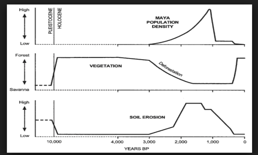
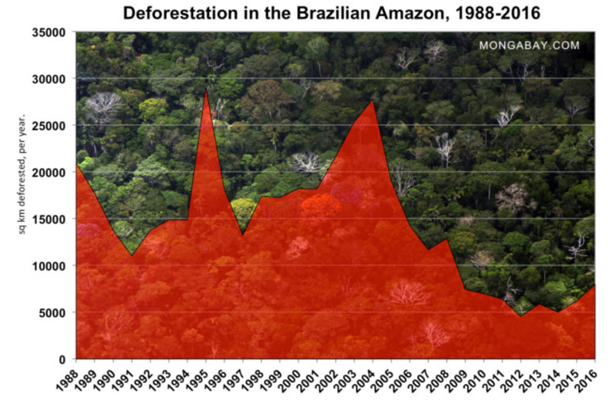
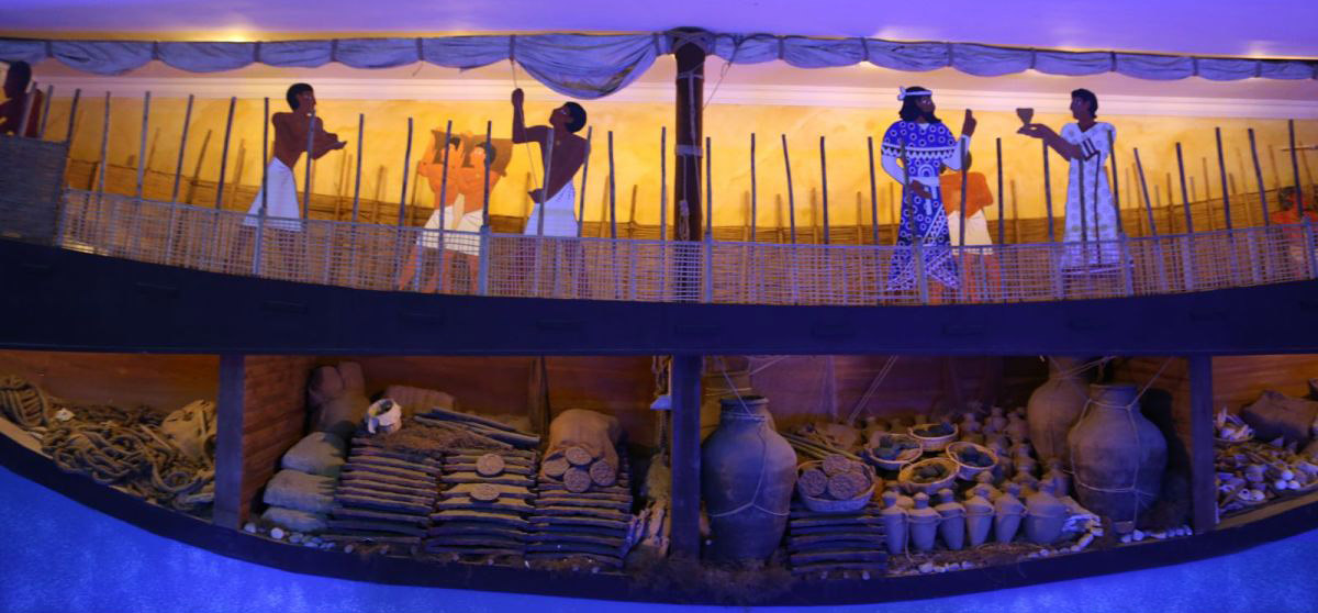
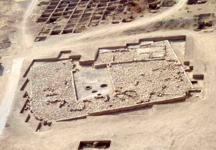
The fall of the Mayan civilization has puzzled scholars for years. At the Mayan’s peak, the civilization was made up by more than 19 million people. However, during the 8thor 9thcentury the Mayan civilization suddenly collapsed. In his book “Collapse,” Jared Diamond puts forth a theory about the sudden demise of the Mayan civilization. Diamond believes that a prolonged drought which was intensified by rapid deforestation led to the collapse of the once great Mayan civilization (Stromberg).Studying the collapse of the Mayan civilization can be beneficial for a multitude of reasons. We can determine the ways in which the Mayans exacerbated deforestation along with the effects which it had. In the book, “American Anthropologist,” Fisher and Feinman link past human activity to a range of environmental changes. Analysis of past human activity and its effects on the environmental are critical to evaluating contemporary environmental debates and policies. As seen in Figure 1, the decline of the Mayan population was closely tied to rapid deforestation coupled with the soil erosion. The Mayans burned and chopped down their forests in order to clear land for agriculture and also to acquire wood for the elaborate construction of their cities (Stromberg). Deforestation in Central American still remains extremely problematic today. In Honduras, it is estimated that up to 85% of timber which is cut down is done so illegally (Charlotte). Deforestation is a great threat to biodiversity, leading birds, animals and plants to lose their natural habitats. The world’s forests are one big carbon sink, storing and locking away carbon dioxide avoiding its immediate release into the atmosphere. When a tree dies all of the carbon that has been stored away is released back into the atmosphere. If the tree is cut down prematurely, the process is accelerated. Currently global loss of forests is contributing 12-15% of total greenhouse gas emissions (Charlotte). This information about the fall of the Mayan civilization becomes increasingly alarming when we look into what is currently going on in Brazil. Recently, a new President was elected in Brazil, Jair Bolsonar. Bolsonar’s environmental policies can be perceived as being a threat to human existence all together. As seen in Figure 2, deforestation of the Brazilian Amazon has been on a general downtrend. However, this may soon change. Bolsonar’s policies favor business over biodiversity and calls for pro-market ways of exploiting Brazil’s natural resources. Bolsonar also has promised to weaken the enforcement of environmental laws. It is extremely important to learn from the failures of past human societies and civilizations. It is thought that we have 12 years to prevent the dangerous destabilization of the Earth’s climate (The Guardian).  We have seen how deforestation led to the demise of the once great Mayan civilization. Hopefully we will use the information we have learned from the past to solve the deforestation problems which are still extremely prevalent today.


Additional Readings:

www.cropcycle.org/2011/07/25/deforestation-in-central-america/.

https://www.theguardian.com/commentisfree/2018/oct/31/the-guardian-view-on-brazils-new-president-a-global-danger

Figure 1. Population density, Deforestation and Soil Erosion for the Mayan Civilization

Source: https://ourworldindata.org/forests

Figure 2: Deforestation in Brazil

Source: https://rainforests.mongabay.com/amazon/deforestation_calculations.htm

Works Cited   

Charlotte. “Deforestation in Central America.” Crop Cycle,   www.cropcycle.org/2011/07/25/deforestation-in-central-america/.

Fisher, Christopher T, and Gary M Feinman. American Anthropologist .

Stromberg, Joseph. “Why Did the Mayan Civilization Collapse? A New Study Points to .   Deforestation and Climate Change.” Smithsonian.com, Smithsonian Institution, 23 Aug.        2012,www.smithsonianmag.com/science-nature/why-did-the-mayan-civilization-    collapse-a-new-study-points-to-deforestation-and-climate-change-30863026/?no-ist.

“The Guardian View on Brazil’s New President: a Global Danger | Editorial.” The Guardian,          Guardian News and Media, 31 Oct. 2018, .            www.theguardian.com/commentisfree/2018/oct/31/the-guardian-view-on-brazils-new-        president-a-global-danger.

What Soil Conveys About Maya Culture and How It Informs the Present World

Soil used to be cast aside: important only for the provenience of artifacts that were found. With modern technology; however, the matrix itself can provide valuable archaeological evidence. In the case of Tikal, an ancient Maya city in northern Guatemala, chemical analysis of soil has provided conclusive evidence of Maya agriculture (American Society of Agronomy 2012). Corn uses a different photosynthetic pathway than most of the vegetation native to Tikal and produces a higher ration of carbon-13 to carbon-12 in the soil (Eberl 2016). Richard Terry, a soil scientist at Brigham Young University, conducted research on 185 soil cores taken from around Tikal (Figure 1) which have been used to map where the Maya did and did not plant maize (Hollingshead 2013). With the model his team created of long-term corn production in Tikal, it is possible to determine the number of people the city could support (Hollingshead 2013). With this technique, it is then possible to look at modern soil and determine the population limit our agriculture can support before environmental collapse.

Figure 1. Soil scientists from Brigham Young University taking soil samples near Tikal, Gautemala (Gannon 2013).

Soil also provides direct evidence to overexploitation of resources, a problem that persists to this day. The Maya achieved widespread maize production but with this came invisible degenerative soil processes like erosion and fertility depletion (Olson 1981). Soil analysis in Tikal indicated that corn-production occurred mostly in low-lying wetlands called bajos, but erosion was discovered in upslope soils which suggested that farming had spread to hills (American Society of Agronomy 2012). It is likely that the spread of farming was due to increased demand because of population growth, but the larger production drastically affected soil viability and inevitably would have undercut the food source (American Society of Agronomy 2012). Again in Tikal, soil use was mapped based on the color: soil used for agricultural production was lighter than the mineral-rich soil which had been left undisturbed (Olson 1981) (Figure 2). The fact that the soil in Tikal has retained the nutrient character the Maya left it with for thousands of years is a sobering thought. Not only does overexploitation lead to decreased production in the relatively short-term but also affects the ability of future civilizations to survive in the far long-term. We not only need to consider the effects of our agriculture on how much food we can create for the present population, but also whether our supposed sustainability means future civilizations will be unable to survive. In order to maintain an ability for agricultural production the current rate of farming needs to decrease or needs to increase in variation (through consultation with experts on the nutrient use of each specific plant) so as to reduce mineral depletion.

Figure 2. An example of soil color being recorded with a Munsell Color Chart— to be recorded the soils must all be in the same conditions such as sunlight or shade and wet or dry (Maya Research Program).

Reference List:

American Society of Agronomy

  2012  Researchers Unlock Ancient Maya Secrets with Modern Soil Science. Electronic document, https://www.sciencedaily.com/releases/2012/11/121112090732.htm, accessed November 2, 2018.

Eberl, Markus.

  2016  Ancient Maya Agriculture at Tamarindito, Guatemala. Electronic document,  https://my.vanderbilt.edu/universityfundingprograms/2016/11/ancient-maya-agriculture-at-tamarindito-guatemala/, accessed November 2, 2018.

Gannon, Megan.

  2013  How Many Mayans Were There. Electronic document,  https://www.livescience.com/37773-ancient-maya-farms-population.html, accessed November 2, 2018.

Hollingshead, Todd.

  2013  Newly Revealed Maya Farming Hotspots Hold Key to Ancient Culture. Electronic document,  https://news.byu.edu/news/newly-revealed-maya-farming-hotspots-hold-key-ancient-culture, accessed November 2, 2018.

Maya Research Program

  2016  Soil Excavations with the Maya Research Program. Electronic document, https://munsell.com/color-blog/soil-excavation-maya-research-program/, accessed November 2, 2018.

Olson, Gerald W.

  1981  Archaeology: Lessons On Future Soil Use. Electronic document,  http://www.ciesin.columbia.edu/docs/002-225/002-225.html, accessed November 2, 2018.


Additional Content for Interested Readers:

Ballantyne, Marissa.

  2007  BYU Research Team’s Special Methods Find Ancient Maya Marketplace. Electronic document,  https://news.byu.edu/news/byu-research-teams-special-methods-find-ancient-maya-marketplace, accessed November 2, 2018.

Burnett, Richard L., Richard E. Terry, Ryan V. Sweetwood, David Webster, Tim Murtha, and Jay Silverstein

  2012  Upland and Lowland Soil Resources of the Ancient Maya at Tikal, Guatemala. Electronic document,  https://dl.sciencesocieties.org/publications/sssaj/abstracts/76/6/2083, accessed November 2, 2018.

Muhs, Daniel R., Robert R. Kautz, and J. Jefferson MacKinnon

  1985  Soils and the Location of Cacao Orchards at a Maya site in Western Belize. Electronic document,  https://www.sciencedirect.com/science/article/pii/0305440385900573, accessed November 2, 2018.

Parallels in History, the Bronze Age to the Rust Belt

Cities are simply destined to fail. They face the same problems over and over again throughout history. Yet today, many rarely tend to think or believe that our system of cities is at any risk of collapse. However, studying history can give rare insights into both what has already happened in the past and what will inevitably happen in the future.

The Bronze Age Collapse of the 12th century BC can be compared to the decline of the Rust Belt today. The Rust Belt of the United States’s Midwest and Great Lakes regions faces severe depopulation, deindustrialization, and de-urbanization. As the industrial heartland saw its manufacturing jobs moved overseas, steel and coal industries declined, and automation increased, the region has spiraled into severe decline.

The Bronze Age Collapse was a regional breakdown of societal order and depopulation of the Aegean, Anatolia, the Levant, Mesopotamia, and Egypt. Many theories and arguments have been put forth for the cause of the Bronze Age Collapse. From natural disasters such as volcanoes and earthquakes to droughts to invading armies, there is not a definite reason for the collapse. Regardless, the Bronze Age featured several parallels to our modern world.

The map above shows the multiple invasions that rocked the Eastern Mediterranean during the late Bronze Age. However, despite the immense destruction of the cities, note the cities that were able to survive the collapse.

The civilizations of the Mycenaean, Hittites, and Egyptians featured interdependent trade among each other. For example, the Uluburun shipwreck of the late 14th century BC showed the transport of goods as it circled the eastern Mediterranean, especially copper and tin ingots, precursors to bronze. Likewise, today’s world is reliant on a system of global trade. In addition, each civilization depended too heavily on bronze for their armies and warrior aristocracy, and as a means to trade for other goods. The very same bronze, as important as crude oil today, whose need of tin, required imports from as far as modern-day Great Britain. This compares to the Rust Belt whose overreliance on manufacturing and its industry to power its economy. The importance of bronze and industry respectively in their systems meant that even a minor disruption can have enormous impacts.

A side-view replica of the Uluburun shipwreck details the exhaustive collection of goods held by the ship as its voyage circled the Eastern Mediterranean.

However, both histories show that collapse is not inescapable. Several Rust Belt cities have found success by shifting away from manufacturing and diversifying their economies with service industries, higher education, and more specialized industries. Similarly, not all cities met their end during the end of the Bronze Age. Several cities adapted to the changing times either by giving up their overreliance on bronze or simply moving away from the torrent of disasters, droughts, and invaders.

The inability of the systems to adapt to new problems is what led to the collapse of the Bronze Age. And likewise, should the Rust Belt cities continue to believe that manufacturing can make a comeback, they will repeat history. The lessons of the Bronze Age Collapse teach us that although we can handle better our problems, we cannot afford to be reliant on a single form of living or to be afraid to adapt.

Works Cited:

Austin, John C. 2017  A tale of two Rust Belts. The Avenue (blog), December 5, 2017.  http://www.brookings.edu/blog/the-avenue/2017/12/05/a-tale-of-two-rust-belts, accessed November 4, 2018.

Porter, Eduardo 2018  Lessons from Rust-Belt Cities That Kept Their Sheen. New York Times 1 May. New York.

The Human Journey. Ideas that Shaped our Modern World: Connecting with the Gods, The Bronze Age Collapse. http://www.humanjourney.us/ accessed November 4, 2018.  

Image Sources:

Historical Atlas of the Mediterranean. The Bronze Age Collapse (1250-1150 BC) http://explorethemed.com/ accessed November 4, 2018.

The Human Journey. Ideas that Shaped our Modern World: Connecting with the Gods, The Bronze Age Collapse. http://www.humanjourney.us/ accessed November 4, 2018.

Further Reading:

Cline, Eric H 2014  1177 B.C.: The Year Civilization Collapsed. Princeton University Press, Princeton.

Millsap, Adam 2017 The Rust Belt Didn’t Adapt And It Paid The Price. Forbes 19 Jan. Jersey City.

LIDAR Survey Reveals New Information About the Maya Lowlands

For years, archaeologists have been using LIDAR to study ancient Maya sites. Recently, an analysis was released of a 2016 survey of the Maya lowlands. The survey, the largest ever done in the region, covered 2,144 square kilometers of land and uncovered a total of 61,480 ancient man-made structures (Canuto et. al 2018). Although the population density was clearly not homogenous – some areas were very rural while others were were far more urban – the researchers estimate an average population density of about 120 people per square kilometer, or about 7 to 11 million people total (Canuto et. al 2018).  According to Dr. Thomas Garrison, one of the archaeologists involved with analyzing the data, this discovery is revolutionary because it places population estimates in this region at several times more than was previously thought and reveals new information about the politics, economics, and agricultural practices of the area (St. Fleur 2018).

A map of the surveyed regions.

As one might expect, a significant amount of farmland was needed to produce food for such a large population, and this could be found right there in the lowlands (Canuto et. al 2018). According to archaeologist Francisco Estrada-Belli, “All of these hundreds of square kilometers of what we thought were unusable swamp were actually some of the most productive farmland” (St. Fleur 2018). The urban areas would have relied on the rural ones for importing food, since the LIDAR scans show that there was not enough farmland immediately surrounding most of them to support their populations. In fact, the many kilometers of roadways imply a high level of interconnectedness between much of the surveyed area, while the infrastructure layout and connectivity more generally reveals that there was likely large-scale planning done by a centralized power (Canuto et. al 2018).

Some of the LIDAR rendering, showing several houses and other structures.

This LIDAR survey reveals important information about the farming practices of the Maya as well as about the extensive infrastructure and organization of their societies. The intensive farming itself is not an isolated thing, since it is known that Mayan agricultural practices and urban expansion had significant impacts on the land (Stromberg 2012). But what is surprising is the location and extent of the land modification. This study will help archaeologists and historians better understand the Maya lowlands, and develop a better image of what their societies look like, and possibly even why they fell. Since our modern societies are facing increasing environmental crises (also partially from unsustainable farming practices) it is more important than ever to learn from the past to change the future.


Works Cited:

Canuto, Marcello et al.

 2018  Ancient Maya Lowland Complexity as Revealed by Airborne Laser Scanning of Northern Guatemala. Science Magazine, accessed 1 November 2018.

St. Fleur, Nicholas.

 2018  Hidden Kingdoms of the Ancient Maya Revealed in a 3D Laser Map. The New York Times, accessed 1 November 2018.

Stromberg, Joseph.

 2012  Why did the Mayan Civilization Collapse? A New Study Points to Deforestation and Climate Change. Smithsonian Magazine, accessed 3 November 2018.

Image Sources:

Estrada-Belli, Francisco.

 2018  The New York Times, September 27, 2018, https://static01.nyt.com/images/2018/10/02/science/28TB-MAYA/28TB-MAYA-jumbo-v2.jpg?quality=90&auto=webp , accessed 3 November 2018.

Canuto, Marcello et. al

 2018  Science Magazine, September 2018, http://science.sciencemag.org/content/sci/361/6409/eaau0137/F4.large.jpg , accessed 3 November 2018.

Further Reading:

“Drought and the Ancient Maya Civilization.” https://www.ncdc.noaa.gov/abrupt-climate-change/Drought%20and%20the%20Ancient%20Maya%20Civilization

“Mayans Converted Wetland to Farmland.” https://www.nature.com/news/2010/101105/full/news.2010.587.html

Homo Naledi: A Surprisingly Modern Relative

In 2013, a deep, at some points very narrow cave system called Rising Star in South Africa produced bones that would be identified as a new addition to the Homo genus, named Homo naledi. The over 1,500 bones found, belonging to at least 15 individuals of varying ages, shared many traits with ourselves, such as the structure of their hands, wrists and feet, while also having many stark differences, including a much smaller brain that is closer to the Homo habilis (Hendry 2018). This mix of primitive and more modern features is curious, by not that surprising by itself, considering how complex the family tree is and how different members of the genus evolved in different ways.

The more surprising aspect of Homo naledi discovery is the age and location of the bones. To date the remains, the archaeologists who discovered the chamber first used radiometric dating on the flowstones, calcite deposited on the bones by running water that must have covered them at some point, and found that they were around 236,000 years old, meaning that the remains had to be older than that. After finding the minimum age, the team found the other end of the range by looking at how the cave’s natural radioactivity had affected the Homo naledi’s teeth by using electron spin resonance dating and estimated the maximum age to be around 335,000 years old (Greshko 2017). This dating makes the more primitive traits much more surprising because it means they were alive much closer to the time of Homo Sapiens than other members with similar brain sizes that lived millions of years ago (Figure 1), magnifying the complexity of the human’s already complicated evolution because it rejects the idea that brains have strictly gotten bigger and bigger as time has passed.

A timeline of the Homo genus based on the estimated first appearance of each member.


The placement of the bones was also puzzling considering the cave to get to the two chambers that were found is almost impossible to traverse, the chute (Figure 2) getting as narrow as 18 centimeters wide.

A cross section of the Rising Star cave system, showing the pathway that leads to the chamber that had most of the Homo naledi bones.

This brings up the question of why these individuals were brought into the cave system. A lack of marks on the bones and animal bones suggests that they were not dragged into the cave by any other animal (Zhang 2017), their own kind had most likely moved them. This kind of treatment of the dead is strange behavior for creatures with their smaller brains. While other animals today acknowledge their dead, navigating a complicated cave system, and probably having to use fire to do so (Hendry 2018), suggests a higher level of cognition and culture.

References

Greshko, Michael. “Naledi Fossils.” National Geographic, 9 May 2018, https://news.nationalgeographic.com/2017/05/homo-naledi-human-evolution-science/.

Hendry, Lisa. “Homo naledi, your most recently discovered human relative.” The Natural History Museum, 5 September 2018, http://www.nhm.ac.uk/discover/homo-naledi-your-most-recently-discovered-human-relative.html

Zhang, Sarah. “A New Addition to the Human Family Tree is Surprisingly Young.” The Atlantic, 9 May 2017, https://www.theatlantic.com/science/archive/2017/05/homo-naledi-age/525825/.

Images

http://www.sciencemag.org/news/2017/05/mysterious-human-species-lived-alongside-our-ancestors-newly-dated-fossils-suggest

https://medium.com/@johnhawks/renewed-excavations-in-the-rising-star-cave-ecb806f816d4

Additional Readings

https://daily.jstor.org/homo-naledi-and-paradigm-shift/.

http://www.pnas.org/content/early/2018/05/08/1720842115

The Application of Forensic Dentistry through Multiple Means

Forensic dentistry or forensic odontology is a discipline that applies dental knowledge to criminal and civil laws. It is responsible for areas including identification of found human remains, identification in mass fatalities, and age estimation.

Disaster types and modes of identification of victims

The first case in which a dentist used dental evidence in a court case demonstrated the method of Comparative Dental Identification. In 1814, a lecturer of anatomy Dr. Granville Sheep Pattison and two of his students in Scotland were charged for the violation of Mrs. Mc Alister grave. They have moved the body of Mrs. Alister after the burial to the nearby college. Mrs. Alister’s dentist Dr. James Alexander testified that the maxillary denture of one of the heads in the dissection room fit Mrs. Alister. The dental identifications of individuals are also effective after mass fatalities, such as the Sumantra Andaman earthquake and Tsunami waves in Indian Ocean in 2004. More than 92% of non-Thai were identified ,and out of them 80% were identified by dental formation.

The dental features on postmortem remains can be compared with ante mortem dental records, including written notes, study casts and radiographs. In the system of identification, dental restorations, similarities and discrepancies are noted. How are the discrepancies formed? In some cases, they are related to time lapse between ante mortem and post-mortem records; while in other situations, the discrepancies are unexplainable. Thus, there are four conclusions recommended when reporting identification results: positive identification, possible identification, insufficient evidence, and exclusion.

Postmortem PM (a) and ante mortem AM (b) dental radiograph with many restorations (dense radio opacity)

One process about forensic dentistry is to recover the life of a set of human remain: we can not only identify this person’s physical features, but also decipher the life experiences, such as socio-economic status includes occupation, dietary habits, and habitual behaviors, dental or systemic diseases. Erosion can suggest alcohol, substance abuse, an eating disorder or even hiatus hernia, while stains can indicate smoking, tetracycline use or betel nut chewing. The quality, quantity, presence or absence of dental treatment may indicate socioeconomic status or country of residence. These dental profiles can help forensic artists construct a facial reproduction.

Forensic dentistry is also utilized to determine the age, ancestry, and sex. For example, in 1897, due to the story which said another child instead of Prince Louis XVII was buried in the monument, three experts aged the skeleton near the side of the church at between 16 plus and 18 plus years, proving that the remains were not Dauphin. What’s more, a forensic dentist can determine race within three major groups (Caucasoid, mongoloid and negroid) from skull appearance and tooth features such as cusp of Carrabelle, shovel-shaped incisors and multi cusped premolars. Sex can be examined by the presence or absence of y-chromatin and DNA analysis.

References:

https://www.ncbi.nlm.nih.gov/pmc/articles/PMC4439663/

https://www.ncbi.nlm.nih.gov/pmc/articles/PMC4111024/

Campbell JM. Glasgow: Pickering and Inglis, Ltd; 1963. Dentistry then Now.

Schuller-Götzburg P, Suchanek J. Forensic odontologists successfully identify tsunami victims in Phuket, Thailand. Forensic Sci Int. 2007;171:204–7.

Craniofacial identification by comparison of antemortem and postmortem radiographs: two case reports dealing with burnt bodies. Campobasso CP, Dell’Erba AS, Belviso M, Di Vella G Am J Forensic Med Pathol. 2007 Jun; 28(2):182-6.

Body identification guidelines. American Board of Forensic Odontology Inc. J Am Dent Assoc. 1994 Sep; 125(9):1244-6, 1248, 1250 passim.

Amoedo O. Paris: Masson Co., Booksellers L’Academie of Medicine; 1898. Dentistry in Forensic Medicine.

[Studies on sex determination using human dental pulp. II. Sex determination of teeth left in a room]. Adachi H Nihon Hoigaku Zasshi. 1989 Feb; 43(1):27-39.

Review A look at forensic dentistry–Part 1: The role of teeth in the determination of human identity. [Br Dent J. 2001]

Further Reading:

https://www.ncbi.nlm.nih.gov/pmc/articles/PMC4149164/

https://www.adc-fl.com/dental-anthropology-and-bioarchaeology/

Images:

https://www.ncbi.nlm.nih.gov/pmc/articles/PMC4439663/

Obsidian: Ancient Tools have Modern Purpose

Since ancient times, obsidian rock has been useful in tool making, as well as serving many other purposes. Obsidian is an igneous rock which is rich in silica and has a low water content. It appears black and shiny in its pure form but is often covered in an outer layer that is more brown in color and appears dull and rough. Obsidian rock was used by early human civilizations to create tools such as arrowheads, blades, and other sharp objects. It is also suggested that obsidian tool knapping could have been used in some cultures as a way for male knappers to impress potential female partners. Using knapping- the creation of stone tools by way of percussion- early humans were able to produce almost-modern objects, some of which are still being utilized today.

Two arrowheads produced from obsidian through the process of knapping. Arrowheads would only be found in areas where hunting by bow and arrow was prevalent.

Obsidian is especially useful for its sharp properties, and this is the reason obsidian tools are still on the market and being studied and used in the twenty first century. Obsidian has incredibly useful and unique properties. The average household razor blade is somewhere between 300 and 600 angstroms (unit of measurement used to measure blade fineness). An obsidian blade measures in at only 30 angstroms, making it very useful in precise cutting. For its extreme sharpness, modern surgeons have continued to utilize obsidian tools in their work, especially in precise surgeries.

Specifically, Dr. Lee Green at the Department of Family Medicine at the University of Alberta says it is not uncommon for him to use obsidian blades in his work. Obsidian’s makeup creates a smooth and continuous edge on a blade, while regular steel tools have a rough edge on their blades at a microscopic level, which can tear into tissue and leave the patient with a longer healing process and more intense scarring. Green has observed that following procedures with obsidian scalpels, patients experience much less scarring than in the same procedure done with steel tools.

A modern obsidian scalpel. These scalpels can be used for precise cutting in surgery.

While it may seem odd to be using tools from the stone age in modern medicine, the blades being used today are different than those of ancient humans. Dr. Green receives his obsidian scalpels from an expert flint knapper, Errett Callahan. Green also knows that using obsidian in medicine is a technique is not useful for every procedure and for every surgeon. Obsidian tools have their time and place. The scalpels can also be helpful for patients who might be allergic to the materials used for most surgical tools, such as steel and metal.


Sources:

Shadbolt, Peter. “How Stone Age Blades Still Cut It in Surgery.” CNN, Cable News Network, 2 Apr. 2015, www.cnn.com/2015/04/02/health/surgery-scalpels-obsidian/index.html.

King, Hobart M. “Obsidian.” Geology, geology.com/rocks/obsidian.shtml.

Britannica, The Editors of Encyclopaedia. “Obsidian.” Encyclopædia Britannica, Encyclopædia Britannica, Inc., 10 May 2018, www.britannica.com/science/obsidian.


Additional Readings/videos

https://www.ncbi.nlm.nih.gov/pubmed/8415970

Pictures:

https://www.spectrum-scientifics.com/Obsidian-Replica-Arrowhead-p/5826.htm

https://www.cnn.com/2015/04/02/health/surgery-scalpels-obsidian/index.html


What the Temple of Ebla Tells Us About the Cult of Ishtar

According to Babylonian myth, Ishtar––known as Inanna in Sumerian Myth––was a powerful goddess who had control over war and love; she brought forth rain and thunderstorms, which, since her myth was mostly rooted in Mesopotamia, served a central role in the agricultural aspects of daily life. Ishtar, often represented by doves, was also the goddess of fertility and was revered by many, both of high and low status. As Ishtar rose in prominence, she became central in Babylonian and Sumerian society, and thus became the central figure in the Cult of Ishtar, which expanded throughout the Babylonian and Sumerian sphere of influence. How do archaeologists identify evidence for these cults? Ebla, a town located in modern day Syria, is presumed to be highly influenced by the Cult of Ishtar; the evidence found in the town’s religious temples could help archaeologists accurately describe the goddess and her worshippers, as well as describe the affect that the cult had on the society.

This image is a relief of Ishtar, the Babylonian goddess of fertility, war, and love.

In order to determine the location of a cult, archaeologists must first find attention-focusing devices, such as sacred temples, where the community would presumably go to worship. In Ebla, temples were discovered; religious practices most likely took practice in a central space, bounded by cisterns. Archaeologists found the most evidence for the presence of Ishtar within the temple; As archaeologists began to excavate the stratigraphy around in a favissa, or pit, they discovered a plethora of artifacts, including carnelian lions, bronze bulls, and bronze snakes: all common iconography of Ishtar. The addition of figurines depicting domesticated animals and naked women––symbols of fertility––also suggest Ishtar’s influence within Ebla.

This image depicts the remains of a temple at Elba in modern-day Syria, a site that suggests influence from the Cult of Ishtar.

The archaeologists also began to find pottery sherds dumped in pits, which were then hypothesized to be influenced by the Cult of Ishtar; though they were unable to be completely reconstructed, the decorations of the pottery often depicted a common theme of birds. These birds however, were most likely doves than birds of prey; this hypothesis is supported by the presence of dove bones on the site, which were most likely used as offerings towards the goddess. The presence of doves suggests that Ishtar’s sphere of influence had expanded beyond the Tigris and Euphrates rivers. Though the pottery is not complete evidence for the Cult’s presence, the contents within the pottery is what deems their religious significance. The pottery obtained at the site contained burnt offerings, such as processed food and bones; this signifies the town’s participation in the offering­­s, another major aspect of cult identification.

These findings within the temples’ favissa suggests that Ishtar’s influence was expanding westward, which indicates the Babylonian and Sumerian sphere of influence was growing towards the Mediterranean, allowing their culture to be adopted by more people.


Additional Readings:

https://www.brooklynmuseum.org/eascfa/dinner_party/place_settings/ishtar

https://www.ancient-origins.net/ancient-places-asia/ishtar-gate-and-deities-babylon-001868

https://www.ancient.eu/Ishtar_Gate/

Sources:

Heffron, Yaǧmur. “Inana/Ištar (goddess)”, Ancient Mesopotamian Gods and Goddesses, Oracc and the UK Higher Education Academy, 2016 http://oracc.iaas.upenn.edu/amgg/listofdeities/inanaitar/

Marchetti, Nicoló. Nigro, Lorenzo.

1997  Cultic Activities in the Sacred Area of Ishtar at Elba During the Old Syrrian Period: the Favissae F.5327 and F.5238 Journal of Cuneiform Studies (49): 1-44.

Pinnock, Frances.

2000  The Doves of the Goddess. Elements of the Cult of Ishtar at Elba in the Middle Bronze Age Levant (32:1): 121-128.

Renfrew, Colin, and Bahn, Paul G. Archaeology Essentials: Theories, Methods, Practice. 2nd ed., Thames & Hudson, 2015.

Pictures:

https://www.allposters.com/-sp/Relief-Depicting-Ishtar-and-Tyche-in-the-Likeness-of-Queen-Zenobia-and-Her-Servant-Posters_i12163148_.htm

http://www.ebla.it/escavi__i_templi_paleosiriani.html


Tracing Galena Artifacts at Poverty Point Back to their Source

The Poverty Point archaeological site in northeastern Louisiana is most widely known for its massive earthen mounds measuring up to 72 feet tall and forming six concentric semicircles. At its height from 1200 BCE to 700 BCE, the Poverty Point Native American site had an estimated population of around 5,000 and its advanced architecture and tools indicate a thriving society.  Not only is Poverty Point an architectural wonder, it also serves as an indicator of a widespread trading network throughout the Midwest and Northeast. Stones and artifacts from as far as 1000 miles have been found by archeologists at Poverty Point.

When archeologists first began observing large amounts of stone artifacts at Poverty Point, they were able to identify the key element in many of the artifacts as galena, a shiny silver form of lead (II) sulfide. By 1970, over 700 artifacts containing galena had been identified at Poverty Point and four smaller surrounding settlements. The most common galena artifacts are bird effigy pendants, oval pendants, beads, and polished rectangles.

Galena has been found in a wide range of artifacts at Poverty Point including pendants, beads, polished rectangles and stones. Archeologists believe that these artifacts were often used for ceremonial and decorative purposes at Poverty Point as well as other Native American sites throughout the Southeast.

Archeologists used trace element analysis, the process of identifying elements present in small amounts, in order to trace a material back to its source of origin. Trace element analysis of galena artifacts at Poverty Point indicated that the majority of the rocks originated from the Potosi deposit in Missouri while others were from the upper Mississippi valley. Archeologists also conducted trace element analysis of galena artifacts at seven other Native American sites and found that 55% of the artifacts could be traced to the Potosi deposit and 34% to the upper Mississippi valley while the other 11% was inconclusive. Because of this evidence, archeologists were able to identify a trading pattern that used the Mississippi River, the Ohio River and the Arkansas River as well as the Ouachita stream and stopped at sites including Yazoo Basin and a Native American settlement at Calion.

Galena was by no means the only material traded at Poverty Point. This map shows the source areas for other minerals found at Poverty Point in addition to the two main galena source points which are marked as A and C on this map.

Archeologists have also noted a highly similar style of bird pendants made from galena in four different locations along the Mississippi and Ohio Rivers indicate that galena was traded both as a raw material and as a finished product. This exhibits the shared cultural importance of galena while also indicating variations in cultural traditions.

Additionally, this trade is especially interesting to archeologists as it does not follow the theory of fall off analysis which states that the quantity of a material will decrease with the distance from the source of that material. There are many more galena artifacts at the Poverty Point site in Louisiana than there are at sites closer to the Potosi deposit. This indicates that the trade was not simply a reciprocal exchange, but rather a more complicated directional trading pattern. The Poverty Point trading network is one of the first instances of large scale long distance trade in the Americas that can be fully shown by archeologists. It represents an extremely important development in society as well as social organization.

Additional Readings:

Feasting at Poverty Point

http://pu6xa6xs3q.search.serialssolutions.com/?ctx_ver=Z39.88-2004&ctx_enc=info%3Aofi%2Fenc%3AUTF-8&rfr_id=info%3Asid%2Fsummon.serialssolutions.com&rft_val_fmt=info%3Aofi%2Ffmt%3Akev%3Amtx%3Ajournal&rft.genre=article&rft.atitle=Feasting+at+Poverty+Point+with+Poverty+Point+Objects&rft.jtitle=Southeastern+Archaeology&rft.au=Hays%2C+Christopher+T&rft.date=2018-07-17&rft.issn=0734-578X&rft.eissn=2168-4723&rft.spage=1&rft.epage=15&rft_id=info:doi/10.1080%2F0734578X.2018.1496315&rft.externalDBID=n%2Fa&rft.externalDocID=10_1080_0734578X_2018_1496315&paramdict=en-US

Trace Element Analysis on Pottery from Oaxaca

https://www.amnh.org/our-research/anthropology/research/meso-american-archaeology/projects/10.-trace-element-analysis

References

Hays, Christopher T, Richard A Weinstein, and James B Stoltman

2016 Poverty Point Objects Reconsidered. Southeastern Archeology

Hill, Mark A, Diana M Greenlee, and Hector Neff
2016 Assessing the provenance of Poverty Point copper. Journal of Archaeological Science 6: 351–360

Louisiana Division of Archaeology

2014 Discover Archaeology. Louisiana Department of Culture, Recreation and Tourism

Walthall, John A, Clarence H Webb, Stephen H Stow, and Sharon I Goad

1982 Galena Analysis and Poverty Point Trade. Midcontinental Journal of Archaeology 7: 133–148


Image Citations:

Material Source Map. Louisiana Archaeology Project

https://www.crt.state.la.us/dataprojects/archaeology/virtualbooks/POVERPOI/trade.htm


Galena Artifacts. Louisiana Division of Archaeology

https://www.crt.state.la.us/dataprojects/archaeology/povertypoint/ceremonial-life.html

‘Archaeogenetics’ and the Ancient Beringians

‘Archaeogenetics’, the study of ancient DNA, has opened the door to further understanding Earth’s complex history through examination of humans, animals, and plants. With DNA being a dependable ‘artifact’ in itself, archaeologists can learn much more about the people who once populated the sites they examine.

Many know the story of how North America was “discovered” by white, European explorers, but the origins of the Native Americans they drove away has continued to remain a bit nebulous. However, in 2013, the body of a young girl recovered from a burial pit in Alaska assists in reaching an answer about their origin; the significance lies in her DNA that, when analyzed in 2017, matched Native Americans as well as “ancient north Eurasians who lived in what is now Siberia” (Sample).

Archaeologists at the Upward River Sun site in Alaska where the body of the ancient Beringian girl, named “Xach’itee’aanenh t’eede gaay” (“sunrise-child girl”), was found (Sample).

Examining ancient DNA is complex and often cannot be done, as genetic material degrades easily. Viviane Slon of the Max Planck Institute for Evolutionary Anthropology explains, “not every fossil will yield DNA, and not every fossil will yield enough DNA to reconstruct a full genome” (Moscato). In fact, “the best environments for preserving DNA tend to be cold, dry and stable over long time periods” (Moscato), like that of Alaska.

The body of this young girl yields support of the early Native Americans traveling to America by way of East Asia (Sample). Because ice caps held so much of the ocean’s water during the Ice Age, an open land bridge spanned from Russia to Alaska where the Bering Strait is currently (Tamm; Sample; Renfrew and Bahn 140). The land bridge, called Beringia, housed people from East Asia in addition to acting as a “byway” to a new land.

However, geneticists realized that the remains of the girl recovered were genetically different from modern Native Americans, proving the existence of the previously unknown “ancient Beringians” (Sample). About 34,000 years ago, a group of individuals began to separate from the Asians. By 20,000 years ago, today’s Native American ancestors split off from the ancient Beringians, heading into now-North America and forming the “northern and southern branches” all Native Americans trace back to (Strickland; Moreno-Mayar; Tamm).

This diagram details the formation of Native American populations from early ancestors — Ancient Beringians split off from Ancestral Native Americans about 20,000 years ago with their subsequent movement unknown.

Inevitably, the limits of understanding the people of the past become apparent as there is a shortage of tangible proof of ancient Beringians being on Beringia and where they went after. One can only answer so many questions without exhibiting more speculation than corroborated truth. It is like constructing the outside frame of a puzzle, but not having many connecting pieces on the inside. The traces of ancient Beringians are waiting to be discovered and shared with the world to provide answers about this incredible, lost community.


Works Cited

Cohen, Jennie. “Native Americans Hailed From Siberian Highlands, DNA Reveals.” History.com, A&E Television Networks, 26 Jan. 2012, www.history.com/news/native-americans-hailed-from-siberian-highlands-dna-reveals.

Moreno-Mayar, J. Víctor, et al. “Terminal Pleistocene Alaskan Genome Reveals First Founding Population of Native Americans.” Nature, vol. 553, no. 7687, 2018, pp. 203–207., doi:10.1038/nature25173.

Moscato, David. “The Incredible Science of Ancient DNA.” Earth Touch News Network, Earth Touch, 6 Feb. 2018, www.earthtouchnews.com/natural-world/how-it-works/the-incredible-science-of-ancient-dna/.

Renfrew, Colin, and Paul G. Bahn. Archaeology Essentials: Theories, Methods, Practice. 3rd ed., Thames & Hudson, 2015.

Sample, Ian. “Surprise as DNA Reveals New Group of Native Americans: the Ancient Beringians.” The Guardian, Guardian News and Media, 3 Jan. 2018, www.theguardian.com/science/2018/jan/03/ancient-dna-reveals-previously-unknown-group-of-native-americans-ancient-beringians.

Strickland, Ashley. “11,500-Year-Old Infant Remains Reveal Ancient Population.” CNN, Cable News Network, 5 Jan. 2018, www.cnn.com/2018/01/05/health/ancient-population-discovery-alaska-trnd/index.html.

Tamm, Erika, et al. “Beringian Standstill and Spread of Native American Founders.” PLoS ONE, vol. 2, no. 9, 2007, doi:10.1371/journal.pone.0000829.


Images

https://thumbs-prod.si-cdn.com/CEg9yf-zqGgsDK0AhEMLKXj_h6o=/1072×720/filters:no_upscale()/https://public-media.smithsonianmag.com/filer/f8/3d/f83d9a08-978f-42fa-9ebd-0428fb2e1b74/101610_web.jpg

https://www.thesun.co.uk/wp-content/uploads/2018/01/nintchdbpict000376128856.jpg


Additional Resources

https://www.nps.gov/bela/learn/historyculture/the-bering-land-bridge-theory.htm

https://www.scientificamerican.com/article/first-americans-lived-on-bering-land-bridge-for-thousands-of-years/