How Do the Walls Around the World Function Differently?

After World War Ⅱ, the number of border walls all over the world increases significantly. Nowadays the border situation between the US and Mexico is widely discussed, and a wall is actually in people’s envision. What are some border walls in other countries like? Do they all function as the prevention of illegal migrants and refugees?

Serving similar purpose with the wall between US and Mexico, the security at Calais port between France and UK prevents illegal migrants from entering the UK. The security is equipped with detection technologies, such as heartbeat and carbon dioxide detectors, and both countries funded together for a “control and command center”. One difference between Calais port and US border wall is that Calais port prevents the migration problem “at source”, with the aid of strict systems, while the US border wall exposes migrants into the potential danger in the desert. What’s more, between UK and France governments, there is a promoted joint agreement to determine if the migrants are accepted as asylum seekers, get detained or deported.

Another example is the fences in Europe. Hungary and Slovenia are two countries with the region’s largest expanse of fences. These border fences serve to prevent illegal migrants as well but face more religious issues than the one between US and Mexico. It is revealed that people living near these barriers often find that they serve little purpose and can be psychologically damaging. For example, children in the camp in village are scared of their proximity to the fence.

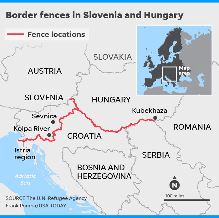
Figure 1. The border wall along Hungary and Slovenia.

We are probably familiar with US president Trump’s use of the Great Wall in China as a comparison to his plans of building the wall. However, these two walls actually serve distinct purposes. The Great Wall was built to prevent exterior military incursion instead of as a security barrier. The construction of Great Wall started in 7th century BC, went through several dynasties, and finished in Ming dynasty. The Great Wall is not impregnable in Chinese history, so perhaps the border wall between US and Mexico will not be totally impregnable as well; moreover, according to Edward Alden, trade policy expert at the Council on Foreign Relations, increased enforcement efforts along the border may explain about 35 to 40 percent of the decline in illegal immigration flow.

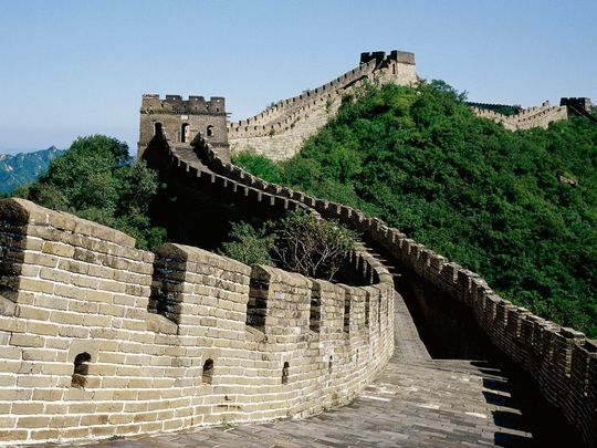
Figure 2. The Great Wall served as the prevention of military attacks.

Nowadays, the border wall that is actually similar to the Great Wall is probably the wall built by Saudi Arabia. The 600-mile-long wall in their northern frontier is built to prevent ISIS from attacking the oil-rich territory.

If the government is determined to use border wall to prevent migration, it might be better to set up an excellent system instead of exposing the migrants in danger in the desert. And even though the wall may serve well politically, we need to think about how to reduce the psychological effect it brings to people who live nearby.


References:

Hjelmgaard, Kim

2018 From 7 to 77: There’s been an explosion in building border walls since World War II. Electronic document,

https://www.usatoday.com/story/news/world/2018/05/24/border-walls-berlin-wall-donald-trump-wall/553250002/, accessed December 2, 2018


BBC News

2016 Calais migrants: How is the UK-France border policed? Electronic document,

https://www.bbc.com/news/uk-33267137, accessed December 2, 2018


Hjelmgaard, Kim

2018 Trump isn’t the only one who wants to build a wall. These European nations already did. Electronic document,

https://www.usatoday.com/story/news/world/2018/05/24/donald-trump-europe-border-walls-migrants/532572002/, accessed December 2, 2018


Michelle Ye Hee Lee

2016 Why Trump’s comparison of his wall to the Great Wall of China makes no sense. Electronic document,

https://www.washingtonpost.com/news/fact-checker/wp/2016/03/08/why-trumps-comparison-of-his-wall-to-the-great-wall-of-china-makes-no-sense/?noredirect=on&utm_term=.972ab6dde511, accessed December 2, 2018


ShantiUniverse

2015 Saudi Arabia Builds 600 Mile Wall to Keep Islamic State OUT! Electronic document,

https://www.youtube.com/watch?v=AG_m4LKOCBk, accessed December 2, 2018


Further Reading:

The (Anthropological) Truth about Walls

https://blogs.scientificamerican.com/anthropology-in-practice/the-anthropological-truth-about-walls/


The Trump Wall in Archaeological Perspective

https://howardwilliamsblog.wordpress.com/2016/11/14/the-trump-wall-in-archaeological-perspective/


Images:

Figure 1. https://www.usatoday.com/story/news/world/2018/05/24/donald-trump-europe-border-walls-migrants/532572002/


Figure 2. https://www.washingtonpost.com/news/fact-checker/wp/2016/03/08/why-trumps-comparison-of-his-wall-to-the-great-wall-of-china-makes-no-sense/?noredirect=on&utm_term=.26dac171f9e3


Immigration Archaeology: The Trails Behind Migrants

As anthropologist Jason De León illustrates, “[a]rchaeology is about ‘trying to understand human behavior in the past through the study of what people leave behind’…[n]obody ever said the past had to be a thousand years ago” (Hartigan Shea 2018). When one hears the term ‘archaeology’, they may be tempted to think of the far past whereas it — as De León emphasizes — could refer to even one minute prior.

Today, immigration across the Mexico-United States border (into the United States) remains a prominent issue. De León has studied this area (specifically the Sonoran Desert where many migrants attempt to cross despite its gruesome conditions) in great depth. De León has been recognized by the MacArthur Foundation in 2017 for his expertise in “[c]ombining ethnographic, forensic, and archaeological evidence to bring to light the human consequences of immigration policy at the U.S.–Mexico border” (MacArthur Foundation 2017). Unsurprisingly, De León is one of the only people within the “[range of] archaeologists and material culture specialists” (Hamilakis 2016) to partake in this field.

A Dora The Explorer backpack, among many others, recovered from near the Mexico-United States border and displayed in the “State of Exception” exhibit at the Sheila C. Johnson Design Center of The New School (Dobnik 2017).

On the Greek island of Lesvos, a similar situation with immigration is occurring. “[M]ore than 500,000 people crossed from Turkey, migrants and war refugees from Syria, Afghanistan, Iraq, as well as many other Asian and African countries, to [this] island with 85,000 permanent inhabitants” (Hamilakis 2016). In venturing to safer land, “[s]ome of [their] camps…can become substantial and highly organized structures despite their makeshift character, as [seen] in northern Greece” (Hamilakis 2016). These people make do with what little they have, setting up shop and moving onwards — these campsites becoming modern sites for archaeological investigation.

An aerial view of a cramped, makeshift camp in Idomeni on the Greece-Macedonia border, housing approximately 7 thousand people at the time of imaging (Telegraph Video 2016).

In regards to what immigrants jettison in regions like the Mediterranean and the Arizona desert, what is left behind “form[s] worthwhile topics for further reflection and study” (Hamilakis 2016) — and a budding ‘branch’ of archaeology. By locating these abandoned objects, voices and identities are given to otherwise invisible people. This growing problem of today mirrors the movement of past peoples and how they have been studied to understand why they left and where they went. However, currently — the time in which this is an issue — the world has the power to work to reach a logical solution. When looking through their belongings, one can see how these people, regarded as ‘invaders’ and ‘inconvenient’, are human. Understanding that these immigrants are giving up everything to head to safer places for acceptable livelihoods is crucial; they are leaving their past lives to stay alive.

Inevitably, there is no reason to disregard the people leaving their countries for our land of dreams, because they are just like the rest of us.

Additional Readings

De León, Jason

  2013 Undocumented migration, use wear, and the materiality of habitual suffering in the Sonoran Desert. Journal of Material Culture 18 (4): 321-345. doi:10.1177/1359183513496489.


Papataxiarchis, Evthhymios

  2016 Being ‘there’: At the front line of the ‘European refugee crisis’ — part 1. Anthropology Today 32 (2): 5-9. doi:10.1111/1467-8322.12237.


Pringle, Heather

  2011 The Journey to El Norte. Archaeology, January/February. Accessed November 24, 2018. https://archive.archaeology.org/1101/features/border.html.


Works Utilized

Dobnik, Verena

  2017 NYC gallery displays migrants’ backpacks, belongings. The Washington Times, February 10. Accessed November 24, 2018. https://www.washingtontimes.com/news/2017/ feb/10/ny-gallery-displays-migrants-backpacks-belongings/.


Hamilakis, Yannis

  2016 Archaeologies of Forced and Undocumented Migration. Journal of Contemporary Archaeology 3 (2): 121-139. doi:10.1558/jca.32409.


Hartigan Shea, Rachel

  2018 Immigration Archaeology: What’s Left at Border Crossings. National GeographicAugust. Accessed November 24, 2018. https://www.nationalgeographic.com/magazine/2018/08/embark-genius-jason-immigration-archaeology/.


MacArthur Foundation

  2017 Jason De León. MacArthur Foundation, October 11. Accessed November 24, 2018. https://www.macfound.org/fellows/986/.


Telegraph Video

  2016 Watch: Aerial footage of crowded migrant camp on Greece-Macedonia border. Telegraph Video, March 2. Accessed November 24, 2018. https://www.telegraph.co.uk/news/worldnews/europe/macedonia/12180807/Watch-Aerial-footage-of-crowded-migrant-camp-on-Greece-Macedonia-border.html.


Images Utilized

Lennihan, Mark

  2017 Migrant Belongings Art [image]. Associated Press. Accessed November 24, 2018. https://www.washingtontimes.com/multimedia/image/ap_migrantsbelongings_art_83724jpg/.


Telegraph Video

  2016 Migrant Camp – Aerial [image]. Telegraph Video. Accessed November 24, 2018. https://secure.i.telegraph.co.uk/multimedia/archive/03587/migrant-camp-aeria_3587034b.jpg.

Danger for the Everglades

Photo above: A boat wends its way through mangroves in the Everglades ecosystem. Phote credit to CARLTON WARD, JR

Image result for national geographic the everglades

Photo Above: Cypress trees in the Everglades. Photo Credit to Terry Eggers.

The Everglades National Park in Florida is the only natural World Heritage site in America to land on the critically in danger list due to human population growth, development, invasive species and fertilizer drainage. As a Floridian I am saddened to learn this. I am also ashamed. I actually was not aware of this until learning it in class. I also was able to learn a lot more about the Everglades in my research for this post.

The Everglades National Park is listed as a World Heritage site, International Biosphere Reserve and a Wetland of International Importance. (National Parks Service) It is also protected under the Cartagena treaty. The Cartagena requires that all parties part of the convention take measures to protect and preserve rare or fragile ecosystems, and the habit of endangered species, within the convention zones. Their purpose is to prevent, control, and reduce pollution of these lands. (EPA)

Once the Everglades covered over 11,0000 square miles of Florida, from Orlando down to the tip of the peninsula. It is now only 2,500 square miles with 1800 miles of canals and dams breaking up the natural system, thanks to human population growth and development since the 20th century. It contains a very slow moving river, 60 miles wide and over 100 miles long. (Lillie Marshall 2011)

The Everglades variety of wet habitats have made a sanctuary for numerous rare and endangered species. The sea turtle, American Alligator, Florida panther, and Bald Eagle are among several endangered species dependent on the ecosystem the Everglades provide. (Everglades Holiday Park Blog 2015) If the ecosystem were to continue to encroached upon and destroyed then many or all of these species would die out.

In addition to the animals and plants that depend on the land, the Native American Seminole tribe also depend on the land. Native people have inhabited the Everglades for thousands of years, and the Seminole tribe depends on the healthy ecosystem for survival. Traditional cultural, religious, and recreational activities, as well as commercial endeavors are dependent on the Everglades. Tribal members believe that if the land dies, so will they, because their identity is so closely linked. (Seminole Tribe of Florida)

Archaeologists are helping to protect and restore this ecosystem. By looking at the archaeological record, they are able to observe and interpret lifestyle changes made by inhabitants as a result of the changing climate and landscape that occurred. This type of information can be useful to scientists and engineers working to restore an environment impacted as dramatically as the Everglades. (Thomas, 2013)

There are many other programs set up to help protect and restore the everglades. The Seminole tribe has the Seminole Everglades Restoration Initiative to improve water quality, storage capacity, and to enhance hydroperiods. Congress had passed the Comprehensive Everglades Restoration Plan to restore, protect and preserve 18,000 square miles of land over 16 Florida counties. The National Park Service website also has many ways to contribute. Let us save this ecosystem and preserve it.

Links to Everglade restorative programs.

https://www.semtribe.com/Culture/SeminolesandtheLand.aspx

https://www.evergladesfoundation.org/the-everglades/restoration-projects/

https://www.nps.gov/ever/getinvolved/index.htm

More Information

https://www.huffingtonpost.com/the-conversation-us/restoring-the-everglades_b_10228720.html

https://www.miaminewtimes.com/news/everglades-are-most-critically-endangered-site-in-us-international-report-finds-9868832

Works Cited

“Cartagena Convention and Land-Based Sources Protocol.” EPA, Environmental Protection Agency, 6 Dec. 2017, www.epa.gov/international-cooperation/cartagena-convention-and-land-based-sources-protocol.

“Culture.” Seminole Tribe of Florida – Culture, www.semtribe.com/Culture/SeminolesandtheLand.aspx.

“Everglades National Park (U.S. National Park Service).” National Parks Service, U.S. Department of the Interior, www.nps.gov/ever/index.htm.

“Everglades Wildlife: Threatened and Endangered.” Everglades Holiday Park, 5 Mar. 2015, www.evergladesholidaypark.com/Everglades-wildlife-threat/.

Marshall, Lillie.                                                                                                              “Danger and Glory in Everglades National Park of Florida.” Around the World “L”, 26 Oct. 2011, www.aroundtheworldl.com/2011/07/26/danger-and-glory-in-everglades-national-park-of-florida/.

Thomas, Cynthia.                                                                                                “Archaeologists Help Preserve the Past, Link to the Future.” Jacksonville District, U.S Army Corps of Engineers, 19 June 2013, www.saj.usace.army.mil/Media/News-Stories/Article/479638/archaeologists-help-preserve-the-past-link-to-the-future/

UNESCO World Heritage Centre. “Everglades National Park.” UNESCO World Heritage Centre, whc.unesco.org/en/list/76.

Image Sources

https://www.nationalgeographic.com/travel/national-parks/everglades-national-park/

https://www.smithsonianmag.com/travel/everglades-national-park-180952529/

The Acropolis Museum: Losing Its Marbles

The Rosetta Stone of Egypt, the Koh-i-Noor Diamond of India, the Parthenon Structures of Greece—time and time again, artifacts find themselves in the hands of a place other than their origin. Better known as the “Elgin Marbles,” these Greek treasures were named after Britain’s Lord Elgin who acquired the pieces from Athens in the early 19th century as an ambassador to the Ottoman Empire, going on to sell them to the British Parliament—of which they still reside in today (Sánchez 2017). The cultural patrimony of objects like the Parthenon Structures for the Greeks fuels a long-held debate about whether or not artifacts that are separated from the group or country they originated from “belong” to their respective origins. Who is the keeper of one’s history? Who should be? Where does this history—these artifacts—belong?

The horsemen of the north frieze of the Parthenon housed in the British Museum, all sixty riders arranged in ten ranks.

While there’s great controversy surrounding the truth of the dealings between Elgin, the British Parliament, and the Ottoman authorities, many Greeks argue that the occupying power at the time of the structures’ acquisition did not hold the authority to “give away such a central part of Greek cultural heritage anyway” (Stone 2018). The Director of the British Museum, Neil MacGregor, argued that the sculptures give the “maximum public benefit” by remaining in the heart of England (Ward 2014). The trustees of the British Museum often defend these claims by expounding on how their museum’s large and diverse public gains “insight into how ancient Greece influenced and was influenced by the other civilizations that it encountered” (Stone 2018). However, if the purpose of exhibiting artifacts that hold cultural significance to countries other than one’s own is to educate the public on other heritages and their histories without having to travel across the world to do so, why not simply create replicas to use and return the original pieces? It only seems just to return the original Parthenon Structures, created by ancient Athenians themselves, back to the people who actually designed and built them.

A marble caryatid, the one missing piece of the six women figurines that previously supported the Erechtheion on the north side of the Acropolis in Athens.

Representatives of Britain often argue that, even in the British Museum, “the Parthenon sculptures in London are an important representation of ancient Athenian civilization in the context of world history” (Selwood 2018). Yet with the advent of Brexit this coming year, what does this mean for the structures’ cultural importance and historical meaning in the greater context of Europe if they will soon reside outside of the European Union after Britain leaves? Controversially, Britain also loaned a part of the Elgin Marbles, a headless statue of the river god Ilissos, to the State Hermitage Museum in Russia, raising tempers among the Greeks since the pieces were to be shipped to another country—one outside of the EU—but still not to be returned to their rightful home in Athens (Ward 2014). By becoming more conscious of and creating more discourse about the historical and cultural importance of the objects that represent one’s past, we are taking steps to protect and appreciate the geographical heritage of some of the world’s greatest artifacts by bringing them back to their origins.


References Cited

Juan Pablo Sánchez

2017 How the Parthenon Lost Its Marbles. National Geographic. Electronic document, https://www.nationalgeographic.com/archaeology-and-history/magazine/2017/03-04/parthenon-sculptures-british-museum-controversy/, accessed November 16th, 2018.


Jon Stone

2018 Greece demands UK open negotiations over the return of the Elgin Marbles. Independent. Electronic document, https://www.independent.co.uk/news/world/europe/greece-uk-elgin-marbles-british-museum-parthenon-acropolis-athens-a8500726.html, accessed Novemeber 17th, 2018.


Janine DeFeo

2011 Which Museums Have the Right to Own World Heritage? Mic. Electronic document, https://mic.com/articles/1852/which-museums-have-the-right-to-own-world-heritage, accessed November 17th, 2018.


Victoria Ward

2014 Why are the Elgin marbles so controversial—and everything else you need to know. The Telegraph. Electronic document, https://www.telegraph.co.uk/news/uknews/11274713/Why-are-the-Elgin-marbles-so-controversial-and-everything-else-you-need-to-know.html, accessed November 18th, 2018.


Ian Jenkins

1994 Greek Architecture and its sculpture in the British Museum. British Museum Press, London, ENG.


Image Sources:

Wally Gobetz

2006 The Horsemen of the North Frieze of the Parthenon. Flickr. Electronic document, https://www.flickr.com/photos/wallyg/302422841, accessed November 18th, 2018.


Trustees of the British Museum

2018 The Parthenon Collection. The British Museum. Electronic document, https://www.britishmuseum.org/research/collection_online/collection_object_details.aspx?objectId=459389&partId=1, accessed November 18th, 2018.


Further Readings:

Dominic Selwood (2018)

How Brexit has revived controversy over the Elgin Marbles in Britain. Independent. https://www.independent.co.uk/news/long_reads/elgin-marbles-parthenon-sculptures-ancient-greece-british-museum-brexit-a8520406.html


Paul Cartledge (2018)

Pressured to Return the Elgin Marbles, Should the British Museum Finally Give Way? Frieze. https://frieze.com/article/pressured-return-elgin-marbles-should-british-museum-finally-give-way

Viking-Age Burials, Beads and Gender Views

Usually when asked to imagine what a Viking may have looked like, many people think of the strong male viking warrior, while the women in their society is confined to being servile and dutiful wives. This sentiment has continued throughout the years, even in a Time article in 2000, described them as meek house workers, reinforcing our view that theirs was a strictly male dominated society. (Lemonick et. al. 2000)  However, studies about Gender in Viking societies completed as early as almost a century ago has shown that gender roles were not as clearly defined as preceding archaeologists and historians may have thought (O’Sullivan, 2016). Specifically, by looking at the graves for Viking age Scandinavians, and the objects found in associated with them, archeologists are able to discover new perspectives and ways of thinking about gender for these people which can help us in understanding modern day culture as well.

It has been found that stereotypically “feminine” designated items such as beads or brooches, that have been considered simple adornments based on our modern concepts of jewelry, are actually very helpful in learning about the Viking culture and helping to do away with previous notions that there was a conclusive division of male and female in Scandinavian society, and how these concepts carry over to modern day Scandinavian society (O’Sullivan, 2016). One such way this is supported is by finding beads in association with burials displaying otherwise “male” attributes or bodies determined to be biologically male. Examples of these male designated graves that have the presence of beads include findings from Norway, Dublin, England, and Iceland. In the cemetery at Ire on the Baltic island of Gotland, ten individuals that were determined to be male were buried with glass beads, and also were buried in association with weaponry (Fig. 2). Some male graves are also found without weapons but still with beads in their graves, which indicates that the inclusion of beads would not confirm nor negate the determination of a grave being named male (O’Sullivan).

In many female determined grave sited, oval or tortoise brooches, and box brooches were found, usually on the chest of the body or below the chin, meaning that they were likely affixed to a dress or used to keep a cape closed. These brooches also reflect the rank and status of the woman, as well as tasks they may have carried out in their lives (Jesch, 1991). These brooches could designate their positioning within social classes. In the Viking social hierarchy, there was three classes; upper, middle, and lower, all of which, women were able to be a part of, as well as had considerable social mobility (Larson, 2012). In fact, the Oseberg ship burial, one of the most famous burials that many do not realize was for a woman (Fig. 1). The remains of two women, one a slave, and the other likelely a noblewoman or völva, a religious shaman of the norse religion. Inside the ship, tapestries, a four wheeled cart, wood works, spades, and a staff were found. In the same area was the Gokstad Ship burial which held the remains of a Viking chieftain, showing that it was possible for women to hold a position as high as a male or higher with in the Viking culture (Larson, 2012).

By looking at the archeological remains of the Vikings and others like it we see that many times there is evidence for less strict divisions of gender, that gender was likely only one small part of what defined their place in culture and that it is important to question previously unchallenged and undisputed assumptions about cultures, both past and present.


Fig 2. Beads typically found in male burials, these are specifically from those found in Cumwhitton Cemetery (https://cola.unh.edu/anthropology/women-traders-viking)


Further Reading:

http://www.academia.edu/23101978/Manifestations_of_identity_in_burial_Evidence_from_Viking-Age_graves_in_the_North_Atlantic_diaspora

https://www.ancient.eu/article/1251/women-in-the-viking-age/


References:

Jesch, Judith.

1991. Women in the Viking Age. Woodbridge, Suffolk: Boydell. https://www.jstor.org/stable/27710925?seq=1#metadata_info_tab_contents


Joanne O’Sullivan.

   2015. Strung Along: Re-evaluating Gendered Views of Viking-Age Beads, Medieval Archaeology,59:1, 73-86. https://www.tandfonline.com/doi/full/10.1080/00766097.2015.1119384


Larson, Caitlin.

2012. VIKING SOCIAL STRUCTURE AND GENDER ROLES IN SCANDINAVIA BASED ON BURIALS AND GRAVE GOODS. The Archaeological Studies Program Department of Sociology and Archaeology. https://core.ac.uk/download/pdf/10597635.pdf


Lemonick, Michael D., and Andrea Dorfman.

2000. “The Amazing Vikings.” Timehttp://content.time.com/time/magazine/article/0,9171,44020,00.html


The Political Impact of ISIS’ Destruction of Antiques

While notorious for public beheadings, ISIS also attacks Syrian and Iraqi artifacts and ancient sites. ISIS follows a strict Salafi interpretation of Islam that prohibits worship of shrines, tombs, and idols, and this interpretation leads ISIS to destroy churches, mosques, and even artifacts and antiquities deemed idolatrous. In 2015, ISIS territories were situated next to several world heritage sites (Figure 1), many of which they destroyed. Irina Bokova, the head of the United Nations Education, Scientific and Cultural Organization, refers to the destruction of antiques as “cultural cleansing”, and says that destroying artifacts “adds to the systematic destruction of heritage and the persecution of minorities that seeks to wipe out the cultural diversity that is the soul of the Iraqi people” (Hartmann 2015).

ISIS employs the brutal war tactic of publically destroying the culture of those who disagree with their ideals, including posting a photo showcasing the destruction of a religious site (Figure 2). ISIS is attempting to erase history. They are symbolically trying to disconnect their enemies from the past and the land, and they are trying to pave the way for a future in which the only history of Syria and Iraq is the history of ISIS.

ISIS’ attacks are demoralizing, horrific, and profitable. Selling and looting antiquities is ISIS’ second highest source of funding after oil, making the destruction of culture both a profitable escapade and a form of cultural warfare. In light of this news, in 2014 the U.S. sought to implement a bipartisan cultural protection czar to reduce the amount of smuggled antiques into the U.S. in order to curtail ISIS funding (Muñoz-Alonso 2014). Both the U.S. and Germany have started imposing laws that would catch smuggled artifacts at their respective borders.

In recent years, ISIS has lost 96% of its territories (Bendaoudi 2018). Still, the sites and antiques ISIS destroyed can never be truly rebuilt, which is why the impact of cultural warfare is so tragic. If the past is forgotten, those in the future can never look back to where they came from, and the connection to the land, the culture, and the people of the past could be lost. Governments and the UN must defend antiques and world historical sites from terror, and their importance must never be forgotten. For this reason, archaeology and the study of the past remain relevant and important subjects today.

Figure 1. ISIS territories in proximity to world heritage sites. Graphic by New York Times. United Nations Educational, Scientific and Cultural Organization (Nimrud is on the Tentative World Heritage List); Institute for the Study of War (control areas); Satellite image by Landsat via Google Earth

Figure 2. A photo by ISIS showcasing the destruction of a religious site. Photo by Hyperallergic

Works Cited:


Muñoz-Alonso, Lorena

2014  Could US Cultural Protection Czar Stop Rampant ISIS Looting? Electronic document, https://news.artnet.com/art-world/could-us-cultural-protection-czar-stop-rampant-isis-looting-173972, accessed November 9, 2018.


Hartmann, Margaret

2015  ISIS is Destroying Ancient Art in Iraq and Syria. Electronic document, http://nymag.com/intelligencer/2015/03/isis-destroys-ancient-art.html, accessed November 9, 2018.


Bendaoudi , Abdelillah

2018    After the “almost 100 percent” Defeat of ISIS, What about its Ideology? Electronic document, http://studies.aljazeera.net/en/reports/2018/05/100-percent-defeat-isis-ideology-180508042421376.html, accessed November 9, 2018.


Additional Content:

“How Antiques Have Been Weaponized in the Struggle to Preserve Culture”

How Antiquities Have Been Weaponized in the Struggle to Preserve Culture

“The Race to Save Syria’s Archaeological Treasures”

https://www.smithsonianmag.com/history/race-save-syrias-archaeological-treasures-180958097/

The Effects of Volcanic Activity on Societies in the Jama River Valley

Volcanoes can be destructive, but they can also lead to beneficial changes in societies. The Jama-Coaque I peoples lived to the west of the Ecuadorian Andes, which includes more than 30 active volcanoes. After the eruption of Pichincha (Figure 1), one of these volcanoes, the Jama-Coaque I peoples left the Jama River Valley (Coutros 2018). However, the destructive volcanoes did not keep people away from the Jama River Valley forever. The Jama-Coaque II peoples, descendents of Jama-Coaque I, resettled the valley hundreds of years later (Coutros 2018). This cycle of settlement and abandonment of the Jama River Valley began long before the Jama-Coaque I peoples left the valley. Around 1880 B.C., Pichincha erupted and the Valdivian peoples were forced to abandon their thriving farms, and around 467 B.C., the eruption of Pululahua, another volcano in the region, led to the Chorrera peoples leaving the Jama River Valley (Coutros 2018).

Figure 1. Ecuador’s Pichincha volcano.

The volcanic activity of the Ecuadorian Andes led to changes in the Jama-Coaque II peoples who returned to the valley. Previous inhabitants of the Jama River Valley, like the Valdivia and Chorrera cultures, relied on floodplain agriculture, which involves growing crops on river banks. When the river system was clogged by volcanic ash, their crops died. By diversifying their nutrient sources and agricultural techniques, the Jama-Coaque II peoples did not have to rely on floodplain agriculture to survive (Coutros 2018). This illustrates the importance of a society’s ability and willingness to change in order to adapt to a changing environment (O’Donnell 2017). The changes made by the Jama-Coaque II peoples led to their success in surviving in the Jama River Valley (Figure 2).

Figure 2. A map of the Jama River Valley and the Ecuadorian Andes.

Communal storage pits, which were used to store food for more than one household, and increased warfare and raiding suggest the rise of a centralized authority in the Jama-Coaque II communities (Coutros 2018). Communal storage and increased warfare allows the Jama-Coaque II peoples to maintain and protect food reserves. While volcanic activity may have pushed communities out of the Jama River Valley for hundreds of years, it also led to the Jama-Coaque II peoples developing practices that allowed them to thrive in the valley.

Volcanic activity has importance in archaeology beyond studying how it affects various cultures. A dating method used in archaeology involves studying layers of volcanic ash deposits. Tephrochronology is the study of volcanic ash, or tephra, deposits (U.S. Geological Survey 2016). Tephrochronology is a helpful tool in areas like Iceland, where tephrochronology was utilized in a study of human impact on the environment (McGovern et al. 2007). In these situations, the layers of ash deposited by volcano eruptions can help archaeologists date artifacts.

Additional Content

This page explains how the Jama-Coaque culture is known for its ceramic creations and describes a Jama-Coaque sculpture: https://www.metmuseum.org/art/collection/search/314183

An article about how early humans may have survived the eruption of a volcano named Toba: https://www.sciencemag.org/news/2018/03/how-ancient-humans-survived-global-volcanic-winter-massive-eruption

References Cited

Coutros, Peter

2018 How Volcanoes Destroy and Nurture Societies. Electronic document, https://www.sapiens.org/column/off-the-map/volcanic-archaeology-pichincha-volcano/, accessed November 8, 2018.


McGovern, Thomas H., Orri Vésteinsson, Adolf Fridriksson, Mike Church, Ian Lawson, Ian A. Simpson, Arni Einarsson, Andy Dugmore, Gordon Cook, Sophia Perdikaris, Kevin J. Edwards, Amanda M. Thomson, W. Paul Adderley, Anthony Newton, Gavin Lucas, Ragnar Edvardsson, Oscar Aldred, and Elaine Dunbar

2007 Landscapes of Settlement in Northern Iceland: Historical Ecology of Human Impact and Climate Fluctuation on the Millennial Scale. American Anthropologist 109(1):27-51. DOI: 10.1525/AA.2007.109.1.27, accessed November 9, 2018.


O’Donnell, Jim

2017 How Vulnerable Are We to Collapse? Electronic document, https://www.sapiens.org/archaeology/hohokam-mimbres-collapse/?utm_content=buffer75cc7&utm_medium=social&utm_source=twitter.com&utm_campaign=buffer, accessed November 9, 2018.


U.S. Geological Survey

2016 USGS Tephrochronology (Tephra) Project. Electronic document, https://geomaps.wr.usgs.gov/tephra/index.htm, accessed November 9, 2018.


Image Sources

Coutros, Peter

2018 How Volcanoes Destroy and Nurture Societies. Electronic document, https://www.sapiens.org/column/off-the-map/volcanic-archaeology-pichincha-volcano/, accessed November 9, 2018.

Parallels in History, the Bronze Age to the Rust Belt

Cities are simply destined to fail. They face the same problems over and over again throughout history. Yet today, many rarely tend to think or believe that our system of cities is at any risk of collapse. However, studying history can give rare insights into both what has already happened in the past and what will inevitably happen in the future.

The Bronze Age Collapse of the 12th century BC can be compared to the decline of the Rust Belt today. The Rust Belt of the United States’s Midwest and Great Lakes regions faces severe depopulation, deindustrialization, and de-urbanization. As the industrial heartland saw its manufacturing jobs moved overseas, steel and coal industries declined, and automation increased, the region has spiraled into severe decline.

The Bronze Age Collapse was a regional breakdown of societal order and depopulation of the Aegean, Anatolia, the Levant, Mesopotamia, and Egypt. Many theories and arguments have been put forth for the cause of the Bronze Age Collapse. From natural disasters such as volcanoes and earthquakes to droughts to invading armies, there is not a definite reason for the collapse. Regardless, the Bronze Age featured several parallels to our modern world.

The map above shows the multiple invasions that rocked the Eastern Mediterranean during the late Bronze Age. However, despite the immense destruction of the cities, note the cities that were able to survive the collapse.

The civilizations of the Mycenaean, Hittites, and Egyptians featured interdependent trade among each other. For example, the Uluburun shipwreck of the late 14th century BC showed the transport of goods as it circled the eastern Mediterranean, especially copper and tin ingots, precursors to bronze. Likewise, today’s world is reliant on a system of global trade. In addition, each civilization depended too heavily on bronze for their armies and warrior aristocracy, and as a means to trade for other goods. The very same bronze, as important as crude oil today, whose need of tin, required imports from as far as modern-day Great Britain. This compares to the Rust Belt whose overreliance on manufacturing and its industry to power its economy. The importance of bronze and industry respectively in their systems meant that even a minor disruption can have enormous impacts.

A side-view replica of the Uluburun shipwreck details the exhaustive collection of goods held by the ship as its voyage circled the Eastern Mediterranean.

However, both histories show that collapse is not inescapable. Several Rust Belt cities have found success by shifting away from manufacturing and diversifying their economies with service industries, higher education, and more specialized industries. Similarly, not all cities met their end during the end of the Bronze Age. Several cities adapted to the changing times either by giving up their overreliance on bronze or simply moving away from the torrent of disasters, droughts, and invaders.

The inability of the systems to adapt to new problems is what led to the collapse of the Bronze Age. And likewise, should the Rust Belt cities continue to believe that manufacturing can make a comeback, they will repeat history. The lessons of the Bronze Age Collapse teach us that although we can handle better our problems, we cannot afford to be reliant on a single form of living or to be afraid to adapt.

Works Cited:

Austin, John C. 2017  A tale of two Rust Belts. The Avenue (blog), December 5, 2017.  http://www.brookings.edu/blog/the-avenue/2017/12/05/a-tale-of-two-rust-belts, accessed November 4, 2018.

Porter, Eduardo 2018  Lessons from Rust-Belt Cities That Kept Their Sheen. New York Times 1 May. New York.

The Human Journey. Ideas that Shaped our Modern World: Connecting with the Gods, The Bronze Age Collapse. http://www.humanjourney.us/ accessed November 4, 2018.  

Image Sources:

Historical Atlas of the Mediterranean. The Bronze Age Collapse (1250-1150 BC) http://explorethemed.com/ accessed November 4, 2018.

The Human Journey. Ideas that Shaped our Modern World: Connecting with the Gods, The Bronze Age Collapse. http://www.humanjourney.us/ accessed November 4, 2018.

Further Reading:

Cline, Eric H 2014  1177 B.C.: The Year Civilization Collapsed. Princeton University Press, Princeton.

Millsap, Adam 2017 The Rust Belt Didn’t Adapt And It Paid The Price. Forbes 19 Jan. Jersey City.

LIDAR Survey Reveals New Information About the Maya Lowlands

For years, archaeologists have been using LIDAR to study ancient Maya sites. Recently, an analysis was released of a 2016 survey of the Maya lowlands. The survey, the largest ever done in the region, covered 2,144 square kilometers of land and uncovered a total of 61,480 ancient man-made structures (Canuto et. al 2018). Although the population density was clearly not homogenous – some areas were very rural while others were were far more urban – the researchers estimate an average population density of about 120 people per square kilometer, or about 7 to 11 million people total (Canuto et. al 2018).  According to Dr. Thomas Garrison, one of the archaeologists involved with analyzing the data, this discovery is revolutionary because it places population estimates in this region at several times more than was previously thought and reveals new information about the politics, economics, and agricultural practices of the area (St. Fleur 2018).

A map of the surveyed regions.

As one might expect, a significant amount of farmland was needed to produce food for such a large population, and this could be found right there in the lowlands (Canuto et. al 2018). According to archaeologist Francisco Estrada-Belli, “All of these hundreds of square kilometers of what we thought were unusable swamp were actually some of the most productive farmland” (St. Fleur 2018). The urban areas would have relied on the rural ones for importing food, since the LIDAR scans show that there was not enough farmland immediately surrounding most of them to support their populations. In fact, the many kilometers of roadways imply a high level of interconnectedness between much of the surveyed area, while the infrastructure layout and connectivity more generally reveals that there was likely large-scale planning done by a centralized power (Canuto et. al 2018).

Some of the LIDAR rendering, showing several houses and other structures.

This LIDAR survey reveals important information about the farming practices of the Maya as well as about the extensive infrastructure and organization of their societies. The intensive farming itself is not an isolated thing, since it is known that Mayan agricultural practices and urban expansion had significant impacts on the land (Stromberg 2012). But what is surprising is the location and extent of the land modification. This study will help archaeologists and historians better understand the Maya lowlands, and develop a better image of what their societies look like, and possibly even why they fell. Since our modern societies are facing increasing environmental crises (also partially from unsustainable farming practices) it is more important than ever to learn from the past to change the future.


Works Cited:

Canuto, Marcello et al.

 2018  Ancient Maya Lowland Complexity as Revealed by Airborne Laser Scanning of Northern Guatemala. Science Magazine, accessed 1 November 2018.

St. Fleur, Nicholas.

 2018  Hidden Kingdoms of the Ancient Maya Revealed in a 3D Laser Map. The New York Times, accessed 1 November 2018.

Stromberg, Joseph.

 2012  Why did the Mayan Civilization Collapse? A New Study Points to Deforestation and Climate Change. Smithsonian Magazine, accessed 3 November 2018.

Image Sources:

Estrada-Belli, Francisco.

 2018  The New York Times, September 27, 2018, https://static01.nyt.com/images/2018/10/02/science/28TB-MAYA/28TB-MAYA-jumbo-v2.jpg?quality=90&auto=webp , accessed 3 November 2018.

Canuto, Marcello et. al

 2018  Science Magazine, September 2018, http://science.sciencemag.org/content/sci/361/6409/eaau0137/F4.large.jpg , accessed 3 November 2018.

Further Reading:

“Drought and the Ancient Maya Civilization.” https://www.ncdc.noaa.gov/abrupt-climate-change/Drought%20and%20the%20Ancient%20Maya%20Civilization

“Mayans Converted Wetland to Farmland.” https://www.nature.com/news/2010/101105/full/news.2010.587.html

Homo Naledi: A Surprisingly Modern Relative

In 2013, a deep, at some points very narrow cave system called Rising Star in South Africa produced bones that would be identified as a new addition to the Homo genus, named Homo naledi. The over 1,500 bones found, belonging to at least 15 individuals of varying ages, shared many traits with ourselves, such as the structure of their hands, wrists and feet, while also having many stark differences, including a much smaller brain that is closer to the Homo habilis (Hendry 2018). This mix of primitive and more modern features is curious, by not that surprising by itself, considering how complex the family tree is and how different members of the genus evolved in different ways.

The more surprising aspect of Homo naledi discovery is the age and location of the bones. To date the remains, the archaeologists who discovered the chamber first used radiometric dating on the flowstones, calcite deposited on the bones by running water that must have covered them at some point, and found that they were around 236,000 years old, meaning that the remains had to be older than that. After finding the minimum age, the team found the other end of the range by looking at how the cave’s natural radioactivity had affected the Homo naledi’s teeth by using electron spin resonance dating and estimated the maximum age to be around 335,000 years old (Greshko 2017). This dating makes the more primitive traits much more surprising because it means they were alive much closer to the time of Homo Sapiens than other members with similar brain sizes that lived millions of years ago (Figure 1), magnifying the complexity of the human’s already complicated evolution because it rejects the idea that brains have strictly gotten bigger and bigger as time has passed.

A timeline of the Homo genus based on the estimated first appearance of each member.


The placement of the bones was also puzzling considering the cave to get to the two chambers that were found is almost impossible to traverse, the chute (Figure 2) getting as narrow as 18 centimeters wide.

A cross section of the Rising Star cave system, showing the pathway that leads to the chamber that had most of the Homo naledi bones.

This brings up the question of why these individuals were brought into the cave system. A lack of marks on the bones and animal bones suggests that they were not dragged into the cave by any other animal (Zhang 2017), their own kind had most likely moved them. This kind of treatment of the dead is strange behavior for creatures with their smaller brains. While other animals today acknowledge their dead, navigating a complicated cave system, and probably having to use fire to do so (Hendry 2018), suggests a higher level of cognition and culture.

References

Greshko, Michael. “Naledi Fossils.” National Geographic, 9 May 2018, https://news.nationalgeographic.com/2017/05/homo-naledi-human-evolution-science/.

Hendry, Lisa. “Homo naledi, your most recently discovered human relative.” The Natural History Museum, 5 September 2018, http://www.nhm.ac.uk/discover/homo-naledi-your-most-recently-discovered-human-relative.html

Zhang, Sarah. “A New Addition to the Human Family Tree is Surprisingly Young.” The Atlantic, 9 May 2017, https://www.theatlantic.com/science/archive/2017/05/homo-naledi-age/525825/.

Images

http://www.sciencemag.org/news/2017/05/mysterious-human-species-lived-alongside-our-ancestors-newly-dated-fossils-suggest

https://medium.com/@johnhawks/renewed-excavations-in-the-rising-star-cave-ecb806f816d4

Additional Readings

https://daily.jstor.org/homo-naledi-and-paradigm-shift/.

http://www.pnas.org/content/early/2018/05/08/1720842115