The Pilentum from Pompeii

By Luna Kang

A stunning chariot was unearthed recently in Pompeii, Italy. Even though many archaeologists unearth all sorts of artifacts in Pompeii, this find was unique because of its exceptional condition and because archaeologists identified it as a pilentum. A pilentum was a ceremonial cart used to transport elite members of the community to ceremonies or parades. By restoring this chariot to its former beauty, archaeologists can understand more about the culture in Pompeii before the eruption of Mt. Vesuvius.

Roman chariots that are found are built from vastly different materials than today’s more modern transportation. Roman chariots were often made of wood for the body and seats and iron for the wheels. This specific chariot was also made with bronze ornaments covering the body’s outside. Each material used to build this chariot helps archaeologists put a date stamp on the artifact. For instance, the iron and bronze metals used are typical of Roman works, such as their armor, weapons, chariots, and boats. By observing what the artifact is made from, archaeologists can place it along a timetable of Earth’s history.

Archaeologists uncovering the chariot.

Archaeologists found the chariot on January 7th, 2023. A small iron artifact caused the archaeologists to believe something bigger was buried beneath them. After excavating for weeks, the team unearthed a big chariot. This splendid chariot, now identified as a pilentum, wasn’t used for gardening, carrying trash, or running errands. This four-wheel processional chariot was reserved for parades and processions or for bringing the lucky bride to her new home. The chariot, which was recently on display at Pompeii for the first time in 2023, was located almost entirely intact in a portico connected to the horse stables at an ancient villa near the walls of the city. A layer of cinerite had protected the high iron wheels, the arms and backrest, and the elegant decorations along both sides of the chassis.

The restored chariot, now on display to the public at the Museo Nazionale Romano.

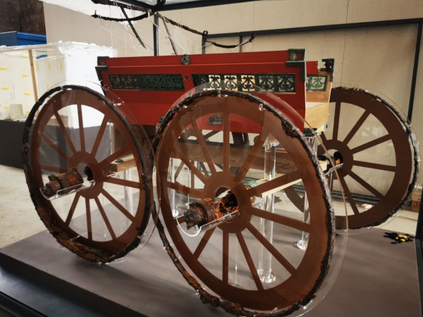
According to Massimo Osanna, Director General of Italian Museums, “When the chariot was discovered during the excavation, it was of exceptional importance due to the information it offered about this form of transport – a ceremonial vehicle – which has no parallel in Italy. . . . This is the first time that a pilentum has ever been reconstructed and carefully studied.” Because of this discovery, made possible by the destructive force of Mt. Vesuvius’s ash, we can understand more about the hierarchy of Roman civilization.

Further Research:
The History of Pompeii
The Full Reconstruction

Reference List:
http://pompeiisites.org/en/comunicati/reconstruction-of-the-ceremonial-chariot-from-civita-giuliana/
https://www.history.com/topics/ancient-rome/pompeii
https://education.nationalgeographic.org/resource/volcanic-ash/

The Cave of Altamira

The Cave of Altamira is one of the biggest archaeological discoveries in history. The cave was discovered by Modesto Cubillas in 1868. It is located in the Spanish province of Cantabria, near the town of Santillana del Mar. The first excavation works of the site began in 1879. In 1985, the cave was declared a UNESCO World Heritage Site, and the cave has since been closed to the public for conservation reasons.

The cave was formed due to collapses due to karstic phenomena of Mount Vispieres. It is about 1,000 meters long, consisting of a series of passages and chambers. It can be divided into three sections; the entrance, the polycrome room, and the gallery. Archaeologists have discovered artifacts from Upper Solutrean (c. 18,500 years ago) and Lower Magdalenian (c. 16,590 – 14,000 years ago) periods, implying that humans inhabited the cave in these time periods. In between these two time periods, the cave was inhabited only by animals.

When Juan Vilanova y Piera and Marcelino Sanz de Sautuola, the first archaeologists to excavate the site, published their work, it was met with much skepticism. A group of French specialists were adamant in rejecting the work of Sautuola and Piera. They argued that the paintings were too well maintained and contained too much artistic quality to be from the Paleolithic era. Sautuola was even accused of paying a contemporary artist to forge the paintings. In 1902, due to other prehistoric paintings being found, the French specialists recant their statements and apologized for their mistake in opposing the work of the original archaeologists.

Archaeologists studying the paintings on the ceiling of the cave.

Archeologists have found animal bones, ash from fireplaces, and flint objects such as knives and axes. Since these artifacts were discovered in different layers of sediments, it is assumed that humans inhabited the cave for long periods of time. The cave was likely well positioned, allowing the inhabitants to take advantage of the wildlife that lived in the valleys of the surrounding mountains. Evidence of human inhabitants has only been discovered at the mouth of the cave.

The most famous aspect of the cave is the numerous cave paintings that line the walls. The paintings depict animals, abstract shapes, human hands, and a series of dots. There are 25 colored images in the cave, mostly red and black. The humans that made the paintings used a flint object to engrave the wall, charcoal to draw a black lines. Later, color was added to the drawings. Impressively, the painters took advantage of the natural contours of the cave walls, giving a three dimensional look to their art.

This is a painting in the Cave of Altamira depicting a bison.

The Cave of Altamira has significantly shifted our views on human life in the Paleolithic period. This was the first time that Paleolithic cave art was discovered, showing that people from this era were able to make carvings and paintings onto rock formations. The cave also gives an insight into the daily life of people of this era, as well as their culture.

Citation:

Lidya Pelayo Alonso, “Atlamira”. World History Encyclopedia. December 13, 2015. https://www.worldhistory.org/Altamira/. 

Alvarez, Stephen, “Altamira Cave.” Ancient Art Archive. April 3, 2022. https://www.ancientartarchive.org/altamira-cave-spain/. 

Raphael Minder, “Back to the Cave of Altamira in Spain, Still Controversial”. The New York Times. July 30, 2014. https://www.nytimes.com/2014/07/31/arts/international/back-to-the-cave-of-altamira-in-spain-still-controversial.html

Additional Links:

https://whc.unesco.org/en/list/310/

https://www.culturaydeporte.gob.es/mnaltamira/home.html

LiDAR and Its Applications to Incredible Discoveries in Guatemala

By: Kieran Chai-Onn

As technology continues to advance, our world is able to continue advancing at an incredible rate. In recent years archaeologists have used the increase in technology to look into the past and provide lessons from our history. By using ground penetrating lasers known as LiDAR (Light Detection and Ranging) archeologists are able to find sites (locations of past human activity) that have previously been covered in dense vegetation or in remote areas (Nicioli, 2023). LiDAR has been extremely useful in the thick rainforests of South America where trying to find past Mayan civilizations has proven difficult for two main reasons. Firstly, the Amazon rainforest covers nearly 40% of the South American continent so LiDAR makes covering nearly 2.72 million square miles feasible (Butler,2022). Secondly, by getting through such dense vegetation you could very easily harm ecosystems. So while LiDAR itself is incredible what was found in Guatemala is a true testament to the power of advancing technology in the archeological sector. 

LiDAR Images of causeways found in Guatemala. Ryan Whitwam 2017.

In the Mirador-Calakmul Karst Basin (MCKB) nearly 775 ancient Maya settlements were revealed in, “one of the largest, contiguous, regional LiDAR studies published to date” (Hansen et al, 2022). In order to achieve these discoveries the process began in 2015 with two aerial surveys of over 1703 square kilometers within the southern half of the MCKB (Hansen et al, 2022). With such an expansive project the LiDAR was able to help cover the region but also allowed archaeologists to learn about the region through, “mapping of settlement observations and cultural features, and enabled detailed environmental, geological, geomorphological, and hydrological interpretation” (Hansen et al, 2022). 

While the Technology is undoubtedly fascinating it is what can be taken away from these LiDAR surveys that really gives us a better understanding of those who walked this earth centuries ago. The discovery of 417 interconnected Mayan cities connected by raised causeways completely changed the modern perception of transportation at the time (Nicioli, 2022). With this interconnectedness of their cities, it has become fascinating how these causeways were a means of communication between people from city to city. While it is assumed that there were no wheeled vehicles on the roads they at times were almost half a football field wide, acting like a spiderweb connecting town to town much like the North American highway system (Nicioli, 2022). Finally, this showed the systematic consistency of construction amongst Mayans because they stacked boxes similar to their pyramids to create the highways (Nicioli, 2022). With incredible construction and many lessons to be taken away, it is fascinating to learn from the Mayans how things we consider modern luxuries might not be so modern after all. 

Above are the raised causeways discovered within the rainforest. Taken by the University of Cambridge (Hansen 2022).

With the use of LiDAR, an incredible understanding of the Mayans has taught us how powerful being an interconnected system of cities can be even centuries ago; something that all would have been hidden and consumed by the sprawling Amazon rainforest. 

Further Research Links: 

The use of LiDAR to find ancient civilizations: https://www.businessinsider.com/ancient-civilizations-that-were-hiding-in-plain-sight-2023-1

How the Mayan Highways were used:https://uchicagoanthropology.shorthandstories.com/maya-roads/index.html#:~:text=General%20Overview%20of%20Maya%20Roads&text=Famous%20for%20not%20having%20vehicles,divert%20surface%20water%20(Pugh).

Works Cited

Butler, Rhett A. “Facts about the Amazon Rainforest for 2022.” Mongabay, February 25, 2022. https://rainforests.mongabay.com/amazon/amazon-rainforest-facts.html.

Hansen, Richard D., Carlos Morales-Aguilar, Josephine Thompson, Ross Ensley, Enrique Hernández, Thomas Schreiner, Edgar Suyuc-Ley, and Gustavo Martínez. “LiDAR Analyses in the Contiguous Mirador-Calakmul Karst Basin, Guatemala: An Introduction to New Perspectives on Regional Early Maya Socioeconomic and Political Organization.” Ancient Mesoamerica, December 5, 2022, 1–40. https://doi.org/10.1017/S0956536122000244.

Nicioli, Taylor. “Discovery of ‘superhighways’ Suggests Early Mayan Civilization Was More Advanced than Previously Thought.” CNN, February 16, 2023. https://www.cnn.com/2023/02/16/world/maya-civilization-causeways-lidar-discovery-scn/index.html.

Whitwam, Ryan. “Lidar Used to Map Ancient Mayan Superhighway System.” Extreme Tech. Extreme Tech, January 31, 2017. https://www.extremetech.com/extreme/243639-lidar-used-map-ancient-mayan-superhighway-system.

The Christian and Jewish Catacombs under Roman Reign

Underneath the land of Rome, there are thousands of early Christian catacombs. Like Pompeii, these archaeological sites in Rome are not time capsules, instead, they tell the story of an active changing process in Christian and Jewish culture. 

The first approach archaeologists use to understand the catacombs is to analyze their locations. Professor Frank Korn, the Author of Hidden Rome and A Catholic’s Guide to Rome talks about why pagans, Jews, and Christians in the 2nd century all chose to build their cemeteries next to the main roads. They have to follow the Extra Muros (the Latin expression for “outside the wall”) law which forbids people from building burials inside the city walls for sanitation purposes. Thus, lots of catacombs are located near the main roads leading out of Rome. 

Some people argue that the Jewish and Christian catacombs were built underground and outside the city center to avoid Roman persecution. But this theory is likely very deviate from the truth. First, the scale of the catacombs is often huge, their capacity varies from several hundred tombs to 90,000 tombs. Frank Korn mentioned in his interview that “some archaeologists thought that if the tunnels were to be placed end to end in a straight continuous line, they would stretch longer than the boot-shaped peninsula of Italy itself, that is to say about 750 miles.” Such a large-scale catacomb can be easily found by the Romans if they were aiming for religious persecution of the Christians. 

Second, the funeral ceremony would take place in the catacomb. The Jewish and Christian ideas about the deceased and the afterlife are very different from those of the Romans who conducted cremation. Christians think that the bodies are very important because all the dead will be resurrected from the tombs and receive their last judgment from God during the last judgment. Thus, they preserve the bodies in the cells of the catacomb. Three types of features can be found in the catacomb: loculus, arcosolium, and cubiculum. Cubiculum also serves as a family chapel for ceremonies and religious activities and is often decorated with frescos and inscriptions. If the Christians were trying to keep the catacomb as a secret shelter, such a place for family gatherings would not appear as a part of the catacomb.

Figure 1. loculus, rectangular tombs to place the bodies.

In fact, the images painted on the walls of these early Christian chapels are influenced by Roman art, and some inscriptions are written in Latin and Greek. Archaeologists have found that the frescos of the famous “Greek Chapel” in the Catacombs of St. Priscilla share a similar art style with Pompeian art. For example, in Christ as the Good Shepherd fresco, Christ is surrounded by three sheep, a representation of the Trinity, and two doves resting on the trees. Sheep and dove are both common symbols in Roman art, and in this case, they were borrowed by the Christians is wrote their own stories and became new types of allegory.

Figure 2. Christ as a Good Sheperd fresco found in the Catacombs of Priscilla

The catacomb is a great treasure that contains numerous stories of the ancient past. Through the archaeological lens, we examine not only the artifacts and the features found in the sites but also relate them to their context and juxtapose them with other sites. The Christians and Romans are not always enemies. Civilizations nourish and learn from each other.

Further Research:

https://www.jstor.org/stable/497187?searchText=Catacomb+archaeology&searchUri=%2Faction%2FdoBasicSearch%3FQuery%3DCatacomb%2Barchaeology&ab_segments=0%2Fbasic_search_gsv2%2Fcontrol&refreqid=fastly-default%3Acffb11bcb73806955146ac838c04695d

References:

Leon, Harry Joshua. “New Material about the Jews of Ancient Rome.” The Jewish Quarterly Review 20, no. 4 (1930): 301–12. https://doi.org/10.2307/1451498.

Frank Korn, Richard Marranca, “The Roman Catacombs: The Labyrinthine City of the Dead.” Popular Archaeology, Jan 14, 2022.

What Feminist Archaeology Reveals about the Lives of Women in El Argar

Meaningful archaeological research occurs when we remove our preconceived notions. Historically, academics assumed women have always been passive and subordinate actors within the political world: this stems from the belief that women are biologically suited for caregiver roles rather than leadership roles (Murr and Zayas 2023). Feminist Archaeology focuses on decentering the Western and male analysis by considering women as active agents within their communities.

Figure 1. Aerial view of the remains of La Almoloya where the El Argar lived and where grave 38 was found. Photograph by the Universitat Autònoma de Barcelona.

The Bronze Age tomb of El Argar, discovered in the Iberian Peninsula in 2014, illustrates the necessity to approach archeology using methodical and empirical observations rather than assumptions. Grave 38 is a mid-seventeenth-century B.C. ceramic jar-like tomb containing two human remains (Lull and Herrada 2021). Pelvic and cranial structures indicated that one was of a woman, aged 25 to 30, and the other was a man, aged 30 to 40. Burial sites are important because they help us understand the values of a culture. The two remains were buried under an elaborate structure, believed to be a political building, indicating they were likely part of the ruling class (Figure 1) (Pinkowski 2021). The woman is adorned with beaded necklaces, rings, hair pins, and a silver diadem (Figure 2). The man has notably fewer possessions and is lying beside a simple dagger.

Figure 2. The silver Argaric diadem from El Argar tomb. Photograph by the Universitat Autònoma de Barcelona.

Without feminist archeology, it would be easy to assume that the female was the romantic partner of a male political figure and that she had been buried with silver jewelry because she was considered beautiful (Geggel 2021). This dismisses her potential importance and prevents us from understanding their social structures more deeply. Grave 38 challenges our previous belief that the women of El Argar were not leaders. When we approach the site from a more neutral and empirical perspective, we see that the female was buried after the death of her partner, indicating that her influence must have extended past his presence. Women generally had more lavish burials than men, indicating their societal importance. The diadem she was buried with is large, extending from her forehead to her nose. It would have been polished to allow those facing her to see their reflection: archeologists believe this was intended to have a threatening effect indicating her authority. A silver awl was buried beside her, indicating she could have been a political leader in the large linen textile industry.

Grave 38 challenges our understanding of El Argar’s social structure. It was previously believed that men were buried with daggers because they played an important role in political decisions (Geggel 2021). However, the location of the tomb and objects buried with the woman disprove such a belief. It is now believed that men of the ruling class were reinforcing political decisions, but women played an essential role in making them. A neutral and feminist approach to examining this site revealed a wealth of information about this society’s social and political structures that would be impossible without approaching archaeology from an empirical perspective.

Further reading

https://www.theguardian.com/world/2021/mar/11/bronze-age-burial-site-in-spain-suggests-women-were-among-rulers

https://www.nationalgeographic.com/history/article/ancient-woman-powerful-european-leader-4000-year-old-treasure-suggests

References

Geggel, Laura. “’Powerful, maybe even frightening’ woman with diadem may have ruled in Bronze Age Spain.” Live Science. March 12, 2021. https://www.livescience.com/diadem-bronze-age-burial-spain.html.

Lull, Vicente et. al. March 11, 2021. “Emblems and spaces of power during the Argaric Bronze Age at La Almoloya, Murcia.” A Review of World Archaeology 95 (380): 329-348. https://www.cambridge.org/core/journals/antiquity/article/emblems-and-spaces-of-power-during-the-argaric-bronze-age-at-la-almoloya-murcia/B27A3C7AD23625DD39C6D4F2C3981C2F.

Murr, Isabel., and Zayas, Elliot. “Engendering the Past: Practices and Potentials of an Explicitly Feminist Archaeology.” Barnard College. (n.d.). https://barnard.edu/engendering-past-practices-and-potentials-explicitly-feminist-archaeology. 

Pinkowski, Jennifer. “She Was Buried With a Silver Crown. Was She the One Who Held Power?” The New York Times. March 11, 2021. https://www.nytimes.com/2021/03/11/science/bronze-age-tomb-women.html

Exploring the World of Underwater Archaeology

Underwater archaeology involves exploring and preserving archaeological treasures submerged in oceans, lakes, and rivers. The emergence of scuba diving in the mid-20th century helped propel the development of underwater archaeology. The submerged sites studied by underwater archaeologists consist of shipwrecks, ancient human remains, and sunken settlements (Blakemore 2021). Some practical challenges and difficulties of underwater archaeology include access to sites, transportation of equipment, weather conditions, specifically the tides and the dynamic nature of water, data interpretation, international and local laws, and the need for skilled divers. LiDAR, sonar, advanced imaging aids, remote sensing devices, advanced photography, and submersibles all aid archaeologists in discovering and documenting submerged sites and artifacts (Blakemore 2021). Forming strong relationships with local communities can be very important for underwater archaeologists because the locals may have valuable knowledge of the waters being explored. For example, local fishers played a crucial role in assisting archaeologists in the discovery of 23 shipwrecks near Fourni, Greece (Blakemore 2021). 

Figure 1. Example of a LiDAR map of Inlet, Virginia.

Learn more about the LiDAR technology: https://oceanservice.noaa.gov/facts/lidar.html#:~:text=Lidar%2C%20which%20stands%20for%20Light,variable%20distances 

One interesting example of an underwater discovery is the identification of submerged DNA in Chios, Greece by archaeologist Brendan Foley and environmental geneticist Maria Hansson. Foley had surveyed a classical shipwreck near the Greek island of Chios but couldn’t identify the cargo. Hansson suggested DNA analysis on the recovered amphorae (Archaeological Institute of America 2009). Amphora is a type of ancient vessel or container, typically made of clay or ceramic, with a distinctive shape. Hansson found genetic traces of olive, oregano, and tree resin, providing direct evidence of the ship’s cargo. Foley and Hansson’s findings provided evidence about the ancient economy. They also demonstrated that, in certain instances, the marine environment can be conducive to DNA preservation (Archaeological Institute of America 2009). This discovery informs fellow archaeologists that conducting DNA analyses in aquatic environments is indeed feasible and can prove a lot about the ancient economy.

Another interesting example of an underwater discovery was in 2013 when a chemical analysis was conducted on an intact, 2,000-year-old Roman medicinal pill discovered in the Relitto del Pozzino, a 2,000-year-old sunken ship off the coast of Tuscany. The shipwreck was located near the Etruscan city of Populonia, a significant Mediterranean Sea trade hub (Mosquera 2019). The excavation, carried out in the 1980s and 90s, uncovered various items, including lamps, glass bowls, bronze jugs, and a medicine chest containing surgical tools, 136 wooden drug vials, and tin vessels with medicinal tablets (Mosquera 2019). These tin vessels remained sealed, preserving the pills. The 2013 chemical analysis revealed that the tablets contained zinc compounds, iron oxide, starch, beeswax, pine resin, and plant-derived materials, suggesting they were used as eye medicine (Mosquera 2019). This discovery and chemical analysis provided valuable evidence and insight into medicinal history.  

Figure 2. Image of tin vessel containing medicinal pills in the Relitto del Pozzino. Photograph by Enrico Ciabatti.

In southern Greece, the site of Pavlopetri, previously explored in the late 1960s, gained renewed archaeological significance in 2009 due to advanced technological methods (Smith 2009). Dating back 5,000 years, Pavlopetri is recognized as the oldest known submerged city. While older underwater settlements exist, Pavlopetri stands out due to its distinct urban characteristics (Smith 2009).

Figure 3. Image of the ruins of the ancient Greek city of Pavlopetri. Photograph by Nikos Pavlakis/Alamy Stock Photo.

Learn more about Palopetri: https://www.theguardian.com/science/2009/oct/16/lost-greek-city-atlantis-myth

The field of underwater archaeology offers new insights and discoveries concerning ancient civilizations, including their economic activities and medical practices. It plays a crucial role in comparing and tracing the evolution of human societies over time.

References: 

Archaeological Institute of America. “Diving into History – The Latest Underwater Discoveries .” Diving into history – the latest underwater discoveries – Archaeology Magazine Archive, 2009. https://archive.archaeology.org/0907/underwater/.

Blakemore, Erin. “Underwater Archaeology Facts and Information.” Culture, May 3, 2021. https://www.nationalgeographic.com/culture/article/underwater-archaeology.

Mosquera, Miguel. “The Five: Underwater Discoveries.” The Guardian, April 7, 2019. https://www.theguardian.com/technology/2019/apr/07/the-five-underwater-discoveries-archaeology-ancient-civilisations-lost-worlds.

Smith, Helena. “Lost Greek City That May Have Inspired Atlantis Myth Gives up Secrets.” The Guardian, October 16, 2009. https://www.theguardian.com/science/2009/oct/16/lost-greek-city-atlantis-myth.

US Department of Commerce, National Oceanic and Atmospheric Administration. “What Is Lidar.” NOAA’s National Ocean Service, October 1, 2012. https://oceanservice.noaa.gov/facts/lidar.html#:~:text=Lidar%2C%20which%20stands%20for%20Light,variable%20distances.

Garbology to the Rescue

Drew Quinn

Garbology to The Rescue

Garbage – the odorous destination for all our tangible items in our society. What many view just as a household staple is, in reality, a significant contributor to understanding nature and our evolving society. Garbage is a hidden treasure box. The archeological study of our garbage is more formally referred to as Garbology. Garbologists study various secondary context items, like products in landfills. Their work provides insight into humankind’s activities such as waste disposal and food consumption. Why is this information so valuable?

As garbologists analyze trash various information is revealed. For example, researchers are able to examine trash and highlight our society’s inadequate job in recycling.  When garbologist discover non-biodegradable plastics and hazardous chemicals in our environment, they are enabled to encourage communities and government officials to make the proper improvements. Additionally, by studying the patterns of our waste generation, garbologists can estimate our overuse of raw materials, energy, and water. With this knowledge, human activities can alter to more sustainable practices. Furthermore, what humans choose to discard reveals much more than one would suspect. For instance, if garbologists see an alteration in the quantity of plant or animal remains discarded, researchers can infer that there has been a change in the ecosystem. Whether it is a decline or increase in these organisms remains, this information grants garbologists the opportunity to stabilize an ecosystem; essential to promoting a healthy environment. 

Figure 1. Landfill, Environmental problem, Waste. Photographed by Ray Van Eng

As our waste decomposes in these landfills greenhouse gases are emitted into the air contributing to our growing climate crisis. Due to the field of garbology, researchers are able to mitigate and help reduce our carbon footprint. For example, expert Claire Parchem shares her experience working at a startup called AMP Robotics. This company programs AI-driven robots that sort waste and recyclables. This artificial intelligence “uses computer vision to recognize patterns of specific recyclable materials within a complex waste stream of smashed, folded, and tattered objects—all combined together”(AMP Robotics 2017). Hence, total waste is reduced by a significant portion, while plastic and reusable waste is put back into circulation. Consequently, both greenhouse gas emissions and waste decomposition decrease. I argue the presence of this beneficial company came into existence thanks to the discoveries in garbology. Similar to AMP Robotics, Glacier has developed technology to improve waste management. Using a similar method Glacier utilizes cutting-edge AI to sort through human-disposed items at an affordable and accessible cost. As garbology continues to undercover humans misgiving towards the environment, powerful technology like AI robots will continue to develop and combat our climate crisis. This upcoming and innovative business sector is seeded in the efforts of garbologists.

Figure 2. AMP Robotics raises $55 million for AI that picks and sorts recyclables. Image Credit AMP Robotics.

Further research- Garbology: Diving into trash at Santa Clara University : NPR

AMP Robotics raises $55 million for AI that picks and sorts recyclables | VentureBeat

Reference list 

“Glacier: Recycling Robots to End Waste,” n.d. https://endwaste.io/.

AMP Robotics. “Latest News — AMP Robotics,” n.d. https://www.amprobotics.com/news.

Discovery of a 1000 Year Old Mummy in Residential Peru

When one considers the anthropological significance of Peru, most likely the mountain dwelling culture of the Incan Empire comes to mind. Sites such as Machu Picchu have garnered most academics’ attention when studying the ancient civilizations of South America. As someone who has gone to Peru and visited Machu Picchu myself, I cannot understate the magnificence of the site and the culture that erected it; however, it is unwise to think that it is the only incredible archaeological discovery in Peru.

Above is one pyramid found at the Huaca Pucllana site, where the mummy was discovered.

On the coast of Peru, a country renowned for its picturesque mountains and valleys, is the capital city of Lima. At first glance it appears, like many other modern South American cities, to have colonial heritage with many of the buildings being remnants of Spanish conquest. However, in the middle of Lima’s affluent Miraflores district lies the Huaca Pucllana site, belonging to the Ychsma culture that occupied the area over a thousand years ago. Recently, a mummy dating back to the beginning of the Ychsma settlement of the area was discovered surrounded by ceramics and textiles. According to the head archaeologist of the site, Mirella Ganoza: “The uncovered mummy lived possibly as long as a millennium ago, at the beginning of the Ychsma culture that developed on the central coast of modern Peru during a period of social reorganization prior to the arrival of the Incas to the area”.

Pictured above is the Huaca Pucllana site found in the middle of the Miraflores district in present day Lima.

This discovery can be interpreted in a few different ways. Firstly, being in the middle of a city, it affects the normative perception of archaeology occurring in remote places. Differing very much from the standard archaeological site that one may think of, this site has been lived over for centuries. It is a drastic difference from the popular culture idea of sites being abandoned or untouched by humanity for many years. Ganoza highlights this in their address to the media stating: “I find it quite interesting that right in the heart of Miraflores, in the middle of the city, surrounded by modern buildings and constructions, an important site is still preserved, the Huaca Pucllana ceremonial center”. If this is the case, is it possible that there are other sites in urban developments that are yet to be found? It is exciting to imagine there are major archeological discoveries yet to be discovered could plausibly be right under our feet.

Beyond the discovery’s future implications of further excavations, it changes the general public’s perception of South American history and Anthropology. The site sheds light on the cultures that tend to be neglected when discussing South American history. The Ychsma, who are credited with building at least 16 pyramids in the area similar to the one the mummy was discovered, are believed to have dominated the central coast of Peru until the rise of the Inca Empire. Drastically different from the story of the Incans, the discovery of Ychsma sites paints a very different picture about the ancient history of Peru and the Andes region. Hopefully, with more discoveries like this we can begin to articulate the stories of lesser known ancient civilizations of the Americas in a manner these fascinating cultures deserve.

References/additional reading:

https://www.reuters.com/lifestyle/archaeologists-unearth-1000-year-old-mummy-peru-residential-neighborhood-2023-09-06/

https://www.washingtonpost.com/world/2023/09/07/peru-mummy-found-ychsma/

Examining Medical Archaeology

Medical archaeology is a relatively new subfield that analyzes materiality such as surgical tools, human bones, and ancient DNA to study the history of healthcare and medicine. Archaeology proposes engaging questions about medicine and health in relationship to artifacts, features, and structures. Medical archaeology also bridges the gaps in knowledge found in textual formats such as medical history. As an anthropology major and pre-med student, I was delighted to examine medicine through an archaeological lens. Overall, this research was a fun break from wrapping my head around organic chemistry concepts.

Image 1: DNA

There are many archaeological finds relating to ancient medicine and health. For example, a 7th-century BC female skull excavated at Thrace shows definitive evidence of cranial surgery. The skull revealed scraping of cranial bone in width, length, and depth. Meanwhile, in Egypt, the Ebers papyrus details physicians’ medical practices. The papyrus suggests the use of Tar in healing skin conditions and rashes. Additionally, the papyrus notes the use of cannabis for healing fingernails. These archaeological finds suggest advanced healing practices and surgery during antiquity. 


A more modern example of medical archaeology is The Archaeology of 19th Century Health and Hygiene at the Sullivan Street Site In New York City. The site focuses on backyard features and artifacts from four house lots. During the 19th century, medicine was the primary medical treatment for illness. Types of treatment available were home remedies, prescribed medicines, and over-the-counter patent medicines. Patent medicines were more affordable than prescription medicines. 

Some Sullivan Street households were Dr. Robson and a lower-class family at 93 Amity Street. Dr. Robson’s assemblage included only medical bottles. Meanwhile, 93 Amity Street only contained patent bottles. Hygiene was increasingly becoming a priority and was associated with moral status. Hygiene items such as soap containers, basins, and toothbrushes were discovered at each Sullivan Street residence. Once more, there were more items discovered at Dr. Robson’s than at 93 Amity Street. Therefore, access to prescription medicine and hygiene products was based on class and wealth. 

Image 2 medicine bottles

What is archaeological science? Archaeological science is an innovative method of approaching historical health and medical practices with archaeological materials such as skeletal remains and ancient DNA. Skeletal and ancient DNA analysis is used to uncover biological sex, health conditions, and diseases. Iron deficiency, known as anemia, is detected in small holes in the skull and ancient DNA analysis. Interestingly, Ancient DNA has been discovered on objects such as a Paleolithic pendant and in sediment from Pleistocene caves. Overall, Extracting ancient DNA is challenging and easily degraded with modern DNA. Archaeological science is so fascinating because it carries archaeology into the future of scientific research and analysis.

Image 3 Illustration by Martin Rowson

Additional Reading

https://medicalmuseum.health.mil

https://www.sciencedirect.com/journal/journal-of-archaeological-science

https://www.ncbi.nlm.nih.gov/pmc/articles/PMC8178570/

Bibliography

Baker, Patricia Anne 2016Chapter 1, Chapter 7. Essay. In The Archaeology of Medicine in the Greco-Roman World. Cambridge: Cambridge University Press. 

Diamandopoulos, Demetrios 2014Medicine and Archaeology. Essay. In Medicine and Healing in the Ancient Mediterranean. Oxford: Oxbow Books. 

Howson, Jean E. 1993The Archaeology of 19th-Century Health and Hygiene at the Sullivan Street Site, New York City. Northeast Historical Archaeology 22(1): 137–160. 

Ludlow, Hannah 2020Ancient Skin and Haircare. Project Archaeology. https://projectarchaeology.org/2020/04/17/ancient-skin-and-haircare/, accessed September 9, 2023. 

Massilani, Diyendo, Mike W. Morley, Susan M. Mentzer, et al. 2021Microstratigraphic Preservation of Ancient Faunal and Hominin DNA in Pleistocene Cave Sediments. Proceedings of the National Academy of Sciences 119(1). 

Saraceni, Jessica Esther N.d.Woman’s DNA Recovered from Prehistoric Pendant. Archaeology Magazine. https://www.archaeology.org/news/11417-230504-denisova-pendant-dna, accessed September 9, 2023. 

Image Credit

Image 1 Google

Image 2 Howson

Image 3 Martin Rowson

Derinkuyu: A Human Ant Farm

Illustrated cross section of the network of tunnels and rooms of the ancient underground city, Derinkuyu.

The ancient underground city of Derinkuyu, located in present day Turkey, was discovered in 1963 by a man renovating his basement. This massive network of tunnels and rooms extends 280 feet into the earth and contains up to 18 stories. Archaeologists estimate that the city could house 20,000 people. But why was such a large city constructed beneath the earth’s surface? And who could have dug it? And when? And why was it abandoned? Questions like these still plague archaeologists and some of their answers remain undetermined. 

Who could have built such an extensive underground matrix, and when? Archaeologists still aren’t sure. Some christian iconography suggests that they were built by early christians in the first couple centuries CE. Many archaeologists claim that the tunnels were dug before that, by the Phrygians around 700 BCE. However, some believe Derinkuyu could date back to 2000 BCE, built by the Hittites, who dominated the area at the time. If it was the Hittites who built the city, it is certain that they were not the last to reside there. Derinkuyu was likely shared by several different cultures since its original construction. For instance, there is strong evidence to suggest that Christians from the 6th to the 10th century CE made additions to the tunnel network. Determining exactly what cultures inhabited the tunnels is nearly impossible, unfortunately, as any artifacts or iconography to indicate their identity have been replaced with each new community to move in. 

Inside a room of Derinkuyu, containing a circular stone used as a “door” separating one level from the next.

Derinkuyu is located in the historical Cappadocia region, covered in a rocky landscape full of “fairy chimneys”. These stunning natural rock formations are the result of erosion of a type of stone called tuff, which is ironically very soft and ideal for digging. Whoever it was that constructed the underground city had highly advanced rock mining skills, as the soft rock is at high risk of caving in, yet there is no evidence that any rooms ever did. When closed off from the Earth’s surface, the tunnels were ventilated by over 15,000 chimneys. Each was only about 4-5 inches wide, but supplied adequate ventilation to all levels of the city. The upper levels served mainly as the living quarters, as they were the best ventilated. Lower levels were used more for storage as well as a dungeon. All the levels in between contained churches, a convent, a room for wine press, and even housed domestic animals. Some shafts extended even further below the lowest levels, and doubled as wells, which were still being used by modern locals of the area before Derinkuyu’s rediscovery. The name darin kuyu actually translates from Turkish to “deep well”.

For an informational tour of the tunnels, watch this video: https://www.youtube.com/watch?v=7_7uDG-VJZE

“Fairy chimneys” of the Cappadocia region in Turkey, made of tuff stone.

Why was such a large settlement built entirely underground? Most archaeologists share the opinion that Derinkuyu was built as a refuge, whether from enemy armies or the extreme seasons. Enormous rolling stones used to cover the ground level entrances to the city serve as evidence for these claims. Underground, temperatures remained constant and could be regulated, and crops could be stored and protected from the weather. Regardless of the original reason for its construction, Derinkuyu was undoubtedly used as refuge for the local population while the Byzantines and Arabs were at war between the 8th and 12th centuries CE, as well as throughout the Mongol raids of the 14th century. There is even some linguistic evidence in the tunnels that a local Greek population sought shelter there occasionally. After the Greco-Turkish war ended in 1922, the Cappadocian Greeks left the area, taking with them the knowledge that the city, which they had named Malakopia, meaning “soft” in Greek, ever existed beneath the ground. 

Giant rolling stone, used to block entrance to the underground city.

Derinkuyu is not alone beneath the Turkish landscape. Hundreds of subterranean dwellings have been discovered and explored around the area. Until recently, none came close to the grandeur of Derinkuyu. But in 2014, another underground city was discovered nearby in Nevsehir, which may rival Derinkuyu’s impressive size. Though it has yet to be fully explored, seismic surveys indicate that this city may extend as deep as 370 feet, almost 100 feet deeper than Derinkuyu, and contain almost five million square feet. It was similarly built, containing living spaces, kitchens, churches, linseed presses to produce oil for lighting. Artifacts such as grindstones, ceramics, and crosses suggest that this city was used in the Byzantine era and through the Ottoman conquest. However, though we know the Byzantines inhabited the site, we cannot know for sure that they were the people to originally construct it. Questions of who really constructed these massive underground dwellings and when remain unanswered and up to interpretation. 

For information on more subterranean cities in Turkey, check out this website:

The mystery of Derinkuyu’s original construction illuminates a very important aspect of archaeology. While artifacts found at a site may provide reason to believe that their owners did reside there, they do not always prove that their owners were the ones to construct the site as a whole. Throughout human history, property has been passed on from culture to culture. Countless cities have been abandoned by one culture and adopted by another. Countless cities have been captured and reclaimed. Sometimes, we find evidence of the entire lineage of cultures to inhabit these places. However, often, traces of a culture’s presence can be wiped away by time and those who followed. This only emphasizes the fact that nothing in archaeology is certain and there are some questions which have been lost to time and can never be answered.

References:

“Derinkuyu: Mysterious Underground City in Turkey Found in Man’s Basement.” Big Think, June 30, 2022. https://bigthink.com/strange-maps/derinkuyu-underground-city/. 

Pinkowski, Jennifer. “Massive Underground City Found in Cappadocia Region of Turkey.” Adventure, May 4, 2021. https://www.nationalgeographic.com/adventure/article/150325-underground-city-cappadocia-turkey-archaeology.