
By: Kieran Chai-Onn
As technology continues to advance, our world is able to continue advancing at an incredible rate. In recent years archaeologists have used the increase in technology to look into the past and provide lessons from our history. By using ground penetrating lasers known as LiDAR (Light Detection and Ranging) archeologists are able to find sites (locations of past human activity) that have previously been covered in dense vegetation or in remote areas (Nicioli, 2023). LiDAR has been extremely useful in the thick rainforests of South America where trying to find past Mayan civilizations has proven difficult for two main reasons. Firstly, the Amazon rainforest covers nearly 40% of the South American continent so LiDAR makes covering nearly 2.72 million square miles feasible (Butler,2022). Secondly, by getting through such dense vegetation you could very easily harm ecosystems. So while LiDAR itself is incredible what was found in Guatemala is a true testament to the power of advancing technology in the archeological sector.
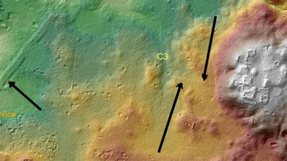
In the Mirador-Calakmul Karst Basin (MCKB) nearly 775 ancient Maya settlements were revealed in, “one of the largest, contiguous, regional LiDAR studies published to date” (Hansen et al, 2022). In order to achieve these discoveries the process began in 2015 with two aerial surveys of over 1703 square kilometers within the southern half of the MCKB (Hansen et al, 2022). With such an expansive project the LiDAR was able to help cover the region but also allowed archaeologists to learn about the region through, “mapping of settlement observations and cultural features, and enabled detailed environmental, geological, geomorphological, and hydrological interpretation” (Hansen et al, 2022).
While the Technology is undoubtedly fascinating it is what can be taken away from these LiDAR surveys that really gives us a better understanding of those who walked this earth centuries ago. The discovery of 417 interconnected Mayan cities connected by raised causeways completely changed the modern perception of transportation at the time (Nicioli, 2022). With this interconnectedness of their cities, it has become fascinating how these causeways were a means of communication between people from city to city. While it is assumed that there were no wheeled vehicles on the roads they at times were almost half a football field wide, acting like a spiderweb connecting town to town much like the North American highway system (Nicioli, 2022). Finally, this showed the systematic consistency of construction amongst Mayans because they stacked boxes similar to their pyramids to create the highways (Nicioli, 2022). With incredible construction and many lessons to be taken away, it is fascinating to learn from the Mayans how things we consider modern luxuries might not be so modern after all.
With the use of LiDAR, an incredible understanding of the Mayans has taught us how powerful being an interconnected system of cities can be even centuries ago; something that all would have been hidden and consumed by the sprawling Amazon rainforest.
Further Research Links:
The use of LiDAR to find ancient civilizations: https://www.businessinsider.com/ancient-civilizations-that-were-hiding-in-plain-sight-2023-1
How the Mayan Highways were used:https://uchicagoanthropology.shorthandstories.com/maya-roads/index.html#:~:text=General%20Overview%20of%20Maya%20Roads&text=Famous%20for%20not%20having%20vehicles,divert%20surface%20water%20(Pugh).
Works Cited
Butler, Rhett A. “Facts about the Amazon Rainforest for 2022.” Mongabay, February 25, 2022. https://rainforests.mongabay.com/amazon/amazon-rainforest-facts.html.
Hansen, Richard D., Carlos Morales-Aguilar, Josephine Thompson, Ross Ensley, Enrique Hernández, Thomas Schreiner, Edgar Suyuc-Ley, and Gustavo Martínez. “LiDAR Analyses in the Contiguous Mirador-Calakmul Karst Basin, Guatemala: An Introduction to New Perspectives on Regional Early Maya Socioeconomic and Political Organization.” Ancient Mesoamerica, December 5, 2022, 1–40. https://doi.org/10.1017/S0956536122000244.
Nicioli, Taylor. “Discovery of ‘superhighways’ Suggests Early Mayan Civilization Was More Advanced than Previously Thought.” CNN, February 16, 2023. https://www.cnn.com/2023/02/16/world/maya-civilization-causeways-lidar-discovery-scn/index.html.
Whitwam, Ryan. “Lidar Used to Map Ancient Mayan Superhighway System.” Extreme Tech. Extreme Tech, January 31, 2017. https://www.extremetech.com/extreme/243639-lidar-used-map-ancient-mayan-superhighway-system.
What are some limitations of the LiDAR technology, and how do archaeologists navigate these issues?
LiDAR is limited for two reasons: The technology is expensive because you have to fly over the area and the data is typically not colored which can make interpretation difficult.. To combat limitations drones have been implemented to cut plane costs and true color photos are overlaid to help interpretation.
Scout Ariel. “Strengths and Limitations of LiDAR” Accessed October 14, 2023. https://www.scoutaerial.com.au/article-lidar/.