The Popham Colony of Maine

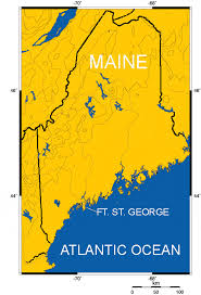
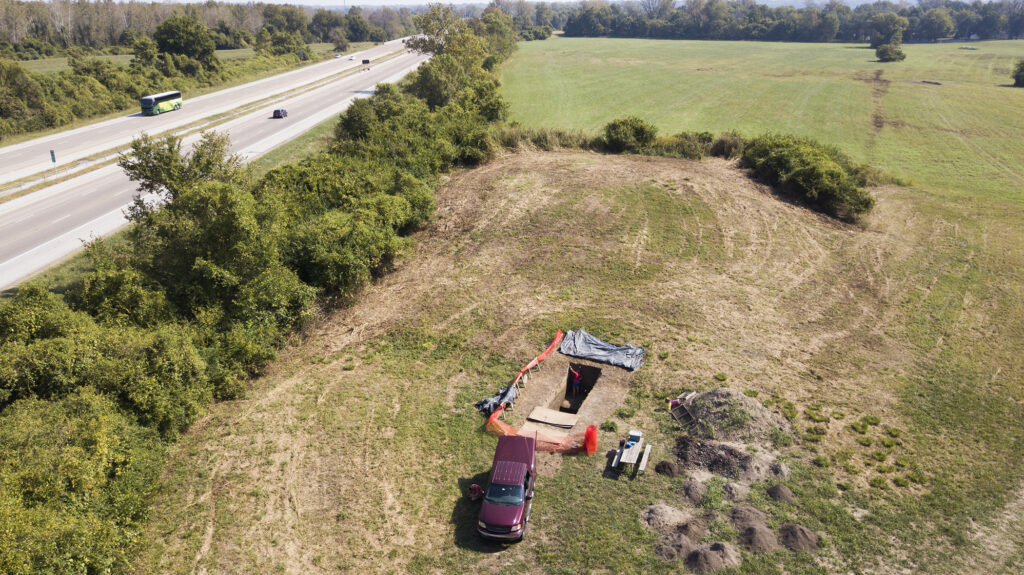
The Popham Colony, established in 1607, is known as one of the first English attempts at settling in North America. The location of this settlement was in southern Maine at the mouth of the Kennebec River next to what is now known as Fort St. George as shown in Figure 1. The Popham Colony was created in hopes that new colonists traveling to North America could engage in trade with Popham. Also, the residents of this colony were tasked with finding valuable resources that could potentially be sold in England for large profits.

The mystery of this colony is derived from its shortness of life. According to records, the Popham colony was constructed in the summer of 1607 and was abandoned in the fall of 1608 (Maine Department of Agriculture). A little over one-hundred settlers that helped build the colony dealt with illness, difficult weather, and very limited resources. A number of food shortages forced many of the colony’s members to sail back to England. Thus began the downfall of Popham. In February of 1608, the leader of the colony, George Popham, passed away due to unknown causes (Andrews, 2017). After George’s death, the morale in the colony plummeted and most of the colonists decided to sail back to Europe. One man in particular, Raleigh Gilbert, took over for George Popham but received word “that he had inherited a title and an estate” in England which persuaded him to abandon his post as leader of the colony (Beckenstein, 2004). Any others that stayed had eventually abandoned the area in search of a more resourceful community.

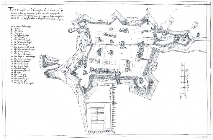
Given this short-lived venture by George Popham and his group of colonists, the site was lost to the elements for 280 years. In 1888, a researcher in Madrid discovered a map or plan of Fort St. George, as shown in Figure 2, drawn by a member of the colony, John Hunt (Beckenstein, 2004). The theory behind this discovery is that the map was copied by a Spanish spy when it was brought back to Europe for analysis by the crown of England. Following this discovery, archaeologist Jeffrey Brain used John Hunt’s plans to confirm the location of the colony in 1994. Between all of the excavations that lasted from 1994 to 2013, Brain has been able to uncover several structures within the fort such as the outline of the fort, the Admiral’s house, and the liquor storage building (Mark, 2021).

Since this most recent discovery, historians and archaeologists have recognized the Popham colony as one of the first European colonies in North America, and the start of extensive colonization in New England.

Figure 1: Mapped view of Maine depicting location of Fort St. George a.k.a the Popham colony (The Archaeology Channel, The Popham Colony Short Video Series)
Figure 2: John Hunt’s plan of Fort St. George (Wikipedia, 2023,  Image copied from http://www.pophamcolony.org/John_HuntMap.gif)

Additional Content:

Popham Colony: Planning, Attempt, and Legacy: https://youtu.be/YmmhYcaKvRs?si=SOT4c9xv5UlLtPcR

Popham Colony: A Slice of Time: https://www.mainestory.info/maine-stories/popham-colony.html

References:

Andrews, Evan. Jun. 1, 2023. “The Lost Colony of Popham.” The History Channel. https://www.history.com/news/the-lost-colony-of-popham#:~:text=One%20account%20from%20January%201608,in%20February%201608%2C%20when%20George

Beckenstein, Myron. Feb., 2004. “Maine’s Lost Colony.” Smithsonian Magazine. https://www.smithsonianmag.com/history/maines-lost-colony-106323660/

Maine Department of Agriculture, Conservation, and Forestry. 2021. “The Popham Colony of 1607.” Bureau of Parks and Lands. https://www.maine.gov/dacf/parks/discover_history_explore_nature/history/popham_colony/index.shtml

Mark, Joshua. Jan. 11, 2021. “Popham Colony.” World History Encyclopedia. https://www.worldhistory.org/Popham_Colony/

The Archaeology Channel. 2023. “ArchaeoVideo Field Communiquè: The Popham Colony, A Short Video Series.” https://www.archaeologychannel.org/video-guide-summary/119-archaeovideo-field-communique-the-popham-colony

Wikipedia. Jun. 22, 2023. “Popham Colony.” https://en.wikipedia.org/wiki/Popham_Colony#:~:text=The%20exact%20site%20of%20the,Maine%27s%20Popham%20Beach%20State%20Park.

Checkmate: The Change from Chaturanga to Chess

Many individuals are familiar with the game of chess or have had the opportunity to play it. The history of the ancient Indian strategy board game, once called Chaturanga, is not as commonly known. Originating in Northern India, the game spread across the world, differing in names. The name we know today is derived from the French term “eches,” which was later translated to “chess” in America. 

About 1500 years ago during the Gupta Empire, the game of Chaturanga came into existence. To simulate the Indian military strategy of that time, the people of Northern India used pieces to depict the four divisions of the military: the infantry, cavalry, elephantry, and chariotry. When discussing the premise of this game, people say, “This game has two of the most essential features inspired from the battle formations of the Indian epic of Mahabharata, that different pieces have different powers and victory depended on the survival of one piece- the king of the modern chess”(Kale, 2021). During the Middle Era, a king surrendering signified the loss of his kingdom, mirroring the way the game is lost when the king is captured.

Figure 1: The infantry, cavalry, elephantry, and chariotry pieces used to play Chaturanga. (Kale, 2021)

The meaning of the pieces in the game of Chaturanga was bigger than just four figures. Each figure represented a valuable member of the kingdom, as shown in Figure 1. The point of using these pieces specifically was to show that everyone in the kingdom was important, despite their size or title. The king needs the queen, rooks, bishops, knights and pawns to survive in the game like he needs them to survive in life. 

The game of chess we know today has undergone transformations since the time of the Gupta Empire. The Chaturanga board began as a non-checkered blackboard differing from the chessboard we see today covered in black and white squares, as shown in Figure 2. The rules governing piece movement in chess differ from those in Chaturanga, with one notable distinction being the absence of checkmates and stalemates in Chaturanga.

Figure 2: A chess set and board used in the FIDE World Championships (Stapczynski, 2021).

Chess undoubtedly shares similarities with Chaturanga while also featuring distinct characteristics. What was once a strategic tool for simulating battle formations, has transformed into a casual game that can be played online. Mirroring military formations preserved the historical and strategic aspects of warfare in the religion. The rules and ways people play games like chess have been adapted to fit the norms of society to provide entertainment for the players, erasing the original intent of the game. By adapting the game for entertainment, it is being commercialized for profit, like competitive chess tournaments, only furthering the loss of the culture the game of Chaturanga once had. People today miss out on the opportunity to see how their ancestors were living during this time. 

The evolution of chess from its historical predecessor, Chaturanga, has brought both continuity and change in the game’s purpose and significance, from a strategic military simulation to a modern form of entertainment.

Further research links

Rules to Chaturanga

https://www.ludoteka.com/clasika/chaturanga-en.html

Origins of other popular board games

https://www.seamedu.com/blog/the-history-and-evolution-of-popular-board-games#:~:text=The%20history%20and%20evolution%20of%20board%20games%20is%20quite%20fascinating,started%20creating%20more%20evolved%20games.

Works Cited 

Colin Stapczynski, “Chess Board Dimensions,” Chess.com, October 4, 2021, https://www.chess.com/article/view/chess-board-dimensions 

Sharwari Kale, “From Chaturanga to Chess- The History of the Origin of Chess,” Homegrown, June 8, 2021, https://homegrown.co.in/from-chaturanga-to-chess-the-history-of-the-origin-of-chess 

Archaeology in Sports, and Sports in Archaeology

Margo Gramiak

The relationship between sports history and archaeology is an interesting one, in that the two disciplines aid each other in different ways. Not only can archaeological practices better our understanding of ancient sports, but ancient sports can help us better understand ancient societies and their structures as a whole. 

Archaeological practices are important for sports historians in their understanding of the games and competitions they’re studying. Being able to actually see and touch artifacts that are relevant to their studies helps tremendously in their comprehension of the sport they’re working with. In most cases, archaeology reveals the existence of the ancient sport in the first place. Needless to say, this is crucial in sports history research. 

Handball, a game played in Ancient Egypt, serves as a great example of these concepts. Archaeological research allows us to understand the transformation of ancient handball, to the modern version that is still played today. Our knowledge of handball’s extensive history was prompted by the discovery of drawings in tombs of Saqqara, Egypt, that date back 5,000 years (Figure 1) (Morgan 2018). The drawings depict four girls throwing balls towards each other (Morgan 2018). These renderings allowed researchers to pinpoint the beginning of the sport. Additional discoveries of other drawings and artifacts further revealed information about the game, and how it’s been played throughout the years (Shereed 2020). The sport’s current day popularity also has helped to fill in gaps that archaeologists were unable to through just artifact analysis. A combination of archaeological research and knowledge passing has helped to reveal handball’s original rules. This is a great example of how archaeological research serves as an important tool in sports history.

Figure 1: Drawing found in tombs of Saqqara, Egypt depicting ancient handball. Image from Nile Scribes. 

Ancient sports are also important for archaeologists to better understand the societies they are studying. Oftentimes, the exploration of pastimes and activities is overlooked in the investigation of past societies. We focus on more basic aspects like where they lived, how they lived, what they ate, etc. Of course these are all important elements in any society, but why neglect the question of, “how did they have fun?” By exploring this question, so much can be revealed about a society and its dynamics. 

Again, take handball in Ancient Egypt for example. Archaeological data has revealed that sports in Ancient Egypt, including handball, were associated with social hierarchies (Shereed 2020). For example, evidence shows that Egyptian leaders and statesmen were the biggest fans of athletic contests, and even provided the equipment for games and events (Mark 2017). There is also evidence indicating that physical fitness and ability played a role in social status (Figure 2) (Houston Museum of Natural Science 2017). Sports were even played at celebrations like the king’s coronation, parties following military victories, religious ceremonies, and festivals (Mark 2017). Evidence of this use is prevalent in artwork (Mark 2017). Understanding the involvement of sports in Ancient Egyptian society reveals dynamics that otherwise would potentially be missed.

Even if they seem to be just “silly games,” it’s important not to neglect the significance of sports in a historical and archaeological context.  

Additional Resources: 

Information about ancient sports:

https://www.oldest.org/sports/sports/

Evolution and history of sports:

https://www.linkedin.com/pulse/evolution-sports-from-ancient-origins-modern-day-alimo-msc

Works Cited:

Shereef, El Doaa, “Ancient Egyptian Sports and Fundamental Principles of Olympics,” Academia.edu. 2020. https://www.academia.edu/44577685/Ancient_Egyptian_Sports_and_Fundamental_Principles_of_Olympics 

Morgan, Kori, “Sports Played in Ancient Egypt,” TheClassroom.com. 2018. https://www.theclassroom.com/sports-played-ancient-egypt-18187.html 

Mark, Joshua, “Games, Sports & Recreation in Ancient Egypt,” WorldHistory,org. April 11, 2017. https://www.worldhistory.org/article/1036/games-sports–recreation-in-ancient-egypt/ 

Greiner, Thomas, “How Kids Had Fun in Ancient Egypt,” NileScribes.org. March 10, 2022. https://nilescribes.org/2022/03/10/how-kids-had-fun-in-ancient-egypt/ 

Houston Museum of Natural Science, “Pharaonic Fitness Test,” Hmns.org. May 19, 2017. https://blog.hmns.org/2017/05/pharaonic-fitness-test/ 

Agriculture: The Cornerstone of Cahokian Society

The ancient city of Cahokia, located in the southwest of Illinois, was once a bustling metropolis that thrived for four centuries. It was the largest pre-Columbian city in North America, and its agricultural practices and the diet of its inhabitants are crucial to understanding the daily lives and cultural dynamics of its citizens. Its large population ensured that agriculture would play a central role in structuring Cahokian society. Archaeological evidence and research provide insights into how the people of Cahokia sustained themselves throughout the city’s impressive history.

Agricultural practices were fundamental to Cahokia’s success. The city’s inhabitants cultivated a diverse array of crops, but maize (corn) was a primary staple of the average diet (Yates, 2020). The Cahokian’s production of maize was crucial, as its large-scale cultivation allowed Cahokia to support a large population. The people of Cahokia also developed agricultural techniques, such as the three sisters farming method (Person, 2023). This method involves planting maize, beans, and squash together, creating a symbiotic relationship, and ensuring the success of all three crops (Figure 1). Maize provided a tall stalk for the beans to climb, while squash vines covered the ground, reducing weed growth and retaining moisture (Editor, 2019) (Figure 1, Figure 2). This agricultural approach allowed Cahokians to maximize their agricultural productivity, thus helping the city support its growing population. 

Figure 1: A diagram depicting the three sisters agricultural method (Editor, 2019)
Figure 2: Three sisters farming in real life (Four String Farm, 2013)

Cahokia was situated on a floodplain of the Mississippi River – a very fertile section of land that provides an ideal environment for agriculture (Kiger, 2019). The rich soil supported not only the crops mentioned in the three-sisters farming method but also a variety of seeds, such as goosefoot, amaranth, a relative of quinoa, gourds, and marsh elder (Seppa, 1997). The specific types of crops cultivated by Cahokians, however, have been lost; but their descendants still exist in the area today (Gattuso, 2019). The surrounding woodland environment also provided an abundance of flora and fauna resources; Cahokia’s location contributed greatly to its abundance of food resources (Kiger, 2019). 

Archaeological evidence has revealed the presence of specialized storage pits within the city, suggesting that Cahokians stored surplus crops for future use (Collins, 1990). These storage facilities were essential for food security, especially during times of crop failure or food scarcity. The careful management of such food resources allowed Cahokians to mitigate the risks associated with agricultural production and large populations. Archaeologists have also discovered evidence of a large trade network connecting Cahokia to other regions and societies (Seppa, 1997). This network enabled the exchange of resources, including food, contributing to the city’s economic prosperity, and fostering a diverse cultural exchange. 

Cahokian society was intricately linked to the Cahokian diet. The abundance of food resources, as well as the development of an efficient agricultural system, allowed for the growth of a complex urban center. The surplus food production supported a hierarchical society, with leaders and elites who controlled the distribution of resources. Therefore, food played a role in not only nourishing and sustaining the Cahokian population but also in shaping social structure and hierarchy. 

Additional Information:

https://www.wild-fed.com/podcast/132

https://www.npr.org/sections/thesalt/2017/02/10/513963490/1-000-years-ago-corn-made-this-society-big-then-a-changing-climate-destroyed-the

References:

Collins, James M. 1990. The Archaeology of the Cahokia Mounds ICT-II. https://libsysdigi.library.illinois.edu/oca/Books2008-07/archaeologyofcah00coll/archaeologyofcah00coll.pdf.

Editor. 2019. “Cahokia.” Open Ended Social Studies. July 3, 2019. https://openendedsocialstudies.org/tag/cahokia/.

Four String Farm. 2013. “The Three Sisters.” Four String Farm. Four String Farm. April 11, 2013. https://fourstringfarm.com/2010/07/09/tres-hermanas/.

Gattuso, Reina. 2019. “How Did Cahokian Farmers Feed North America’s Largest Indigenous City?” Atlas Obscura. March 28, 2019. https://www.atlasobscura.com/articles/native-american-farming-cahokia.

Kiger, Patrick J. 2019. “Ancient Native Americans Once Thrived in Bustling Urban Centers.” HISTORY. November 25, 2019. https://www.history.com/news/native-american-cahokia-chaco-canyon.

Person, Janice. 2023. “Uncovering Cahokia’s Food History & Forgotten Farmscapes.” Grounded by the Farm. August 30, 2023. https://groundedbythefarm.com/cahokia-food-history/.

Seppa, Nathan. 1997. “WashingtonPost.com: Ancient Cahokia.” Www.washingtonpost.com. March 12, 1997. https://www.washingtonpost.com/wp-srv/national/daily/march/12/cahokia.htm#:~:text=Along%20with%20corn%2C%20Cahokians%20cultivated.

Yates, Diana. 2020. “Cahokia’s Rise Parallels Onset of Corn Agriculture.” News.illinois.edu. May 14, 2020. https://news.illinois.edu/view/6367/808689.

Chunkey: More Then Just a Game

Chunkey is a native American game that is played by throwing a spear as close to a rolling stone as possible. One player would roll the stone out and then one or multiple players would throw their respective spears while the stone was still rolling. The closest spear gets the point. This is the basis of the game but it was played in many different varieties depending on where you were from. It is even believed that some tribes from Mexico had a version of the game(Reporter 2020).

Depicted here are a few examples of modern Chunkey stones(Reporter 2020).

Already you can see that this was much more than just a game some Cahokians played. You can see by the spread of the game that there was value in sharing the game and spreading it making it more than just a use of time. Many Cahokian emissaries would carry a Chunkey ball in one hand and a war club in the other. This would signify either a peaceful option or a violent one(Pauketat 2009). Chunkey therefore became a diplomatic tool to offer peaceful solutions to diplomacy. This also reinforces the idea that it was spread so much because these emissaries would have brought it along for the purpose of engaging in peaceful diplomacy.

Although Chunkey did play such a large role in diplomacy for Cahokia it also played a vital role in local day-to-day life. Many players would bet their houses or life savings on the game. Not only was monetary value on the line but also pride. There are accounts of people committing suicide after losing(Reporter 2020). Furthermore, Chunkey was used to settle local disputes. It became a way to settle issues between people without the need for bloodshed. As long as both parties followed the game’s results, Chunkey was used to resolve hunting rights, territorial disputes, or any disagreement between two people(Lepine 2023).

This is a painting by George Catlin depicting a group of people in the act of playing Chunkey(Smithsonian American Art Museum).

The value and power Chunkey carried in Cahokia and all of North America at the time tells us how it was more than what we think of as a game today. It was a political tool that the Cahokians used to engage in diplomacy with other tribes. Chunkey was also a tool that everyday people used to settle disputes and issues they had. Most people at the time in North America used, or at the very least recognized, Chunky as having the ability to be a decider during disputes. People trusted each other to uphold the results of the game and saw Chunkey not just as a game. It was seen as a symbol of peaceful negotiation on a personable level and on a larger scale.

References:

DeBoer, Warren R. “LIKE A ROLLING STONE: THE CHUNKEY GAME AND POLITICAL ORGANIZATION IN EASTERN NORTH AMERICA.” Southeastern Archaeology 12, no. 2 (1993): 83–92. http://www.jstor.org/stable/40712999.

Lepine, Nicolas. 2023. “Montessori Physical Education Blog Chunkey – Traditional Native American Sport.” Montessori Physical Education. April 23, 2023. https://www.montessoriphysicaleducation.com/new-blog/chunkey-traditional-native-american-sport2023/4/7.

Pauketat, Timothy. 2009. “America’s First Pastime – Archaeology Magazine Archive.” Archive.archaeology.org. September 2009. https://archive.archaeology.org/0909/abstracts/pastime.html.

Reporter, LINDSEY BARK. 2020. “Chunkey: A Game of Stones.” Cherokeephoenix.org. August 27, 2020. https://www.cherokeephoenix.org/culture/chunkey-a-game-of-stones/article_cdca67ea-6e61-5457-9309-500d1c95183f.html.

Additional information

PBS website https://www.pbs.org/native-america/chunkey

Interesting Blog https://livesandlegaciesblog.org/2019/10/17/when-games-are-serious-business-chunkey/

Dwindling Validity for Cahokian “Over-Use” Hypothesis

One of the greatest modern archeological mysteries is why Cahokia was seemingly rapidly abandoned for inexplicable reasons. Everything from astrological signs to aliens and time travel, have been offered as possible answers. In this, we see our inability to be content with the unknown. However, this hunt for an explanation has been stunted once again, as one of the most plausible and formerly accepted theories, the “wood overuse” hypothesis, has recently received several massive blows to its validity (Ogilore 2021). 

The “wood overuse hypothesis” explains that due to the rapid development of Cahokia and population growth large-scale consumption of surrounding forestry would leave Cahokia vulnerable to erosion. This would cause “increasingly frequent and unpredictable floods of the local creek drainages in the floodplain where Cahokia Mounds was constructed” (Sherwood 2021). This matches our modern Western understanding of how overconsumption is bad and has led to an increase in natural disasters. Large-scale flooding would be a very forcing event that might spur the abandonment of Cahokia.

Figure 1 2021-03-16, Small parts of wood-intensive stockade reconstructed at Cahokia Mounds State Historic Site (Ogiliore 2021).

However, recent archeological studies have all but debunked this hypothesis. While it is true that, “with a growing population and more mouths to feed, overconsumption of all resources is a real risk”(Ogilore 2021), there is simply no real evidence that has been discovered that would prove the existence of dangerous levels of flooding. Recent excavations around a Mississippian Period (AD 1050–1400) Cahokia mound in a flood plain revealed the ground that the mound was built on was stable until industrial development (Ogilore 2021). This evidence debunks the idea that flooding was the cause of Cahokia’s collapse.

Figure 2 2021, Excavation site near a Cahokian mound (Ogiliore 2021).

Still, ecocide, which is defined as when a society fails due to self-inflicted ecologic disaster, is one of the leading hypotheses about the cause of the fall of Cahokia. Archeologists have proven that Cahokians must have extracted around 10,000 trees in order to fuel many of their developments, so pointing at ecocide is not completely baseless, but in archeology, it has come to be somewhat of a cheap answer. Ecocide narratives are often accepted in archeological conversations, even in the face of a lack of direct evidence that the hypothesized environmental consequences are true (Sherwood 2021). We through our modern lens can not understand why they left, but we feel like we need to be able to explain. Thus ecocide has become a tempting all-encompassing tool to throw out without proper backing in order to find a missing explanation. As previously revealed, this safety net was also cast over Cahokia, despite lacking evidence.

References

Ogliore, Talia. “Study: Scant Evidence That ‘wood Overuse’ at Cahokia Caused Local Flooding, Subsequent Collapse – the Source – Washington University in St. Louis.” The Source, 27 Jan. 2022, source.wustl.edu/2021/04/study-scant-evidence-that-wood-overuse-at-cahokia-caused-local-flooding-subsequent-collapse/.

Sherwood, Sarah. Evaluating Narratives of Ecocide with the … – Wiley Online Library, onlinelibrary.wiley.com/doi/10.1002/gea.21848. Accessed 5 Nov. 2023.

Additional Links

https://www.nytimes.com/2021/04/24/science/cahokia-mounds-floods.html

https://www.nationalgeographic.com/environment/article/why-was-ancient-city-of-cahokia-abandoned-new-clues-rule-out-one-theory

https://atmos.earth/ancient-ties-indigenous-people-and-the-extraterrestrial/

Unearthed Treasures: The Enigmatic Game of Senet

Archaeology never ceases to amaze us with its ability to unearth ancient games, offering us glimpses into the pastimes and cultures of long-forgotten civilizations. Among these fascinating discoveries lies Senet, an ancient board game (Figure 1) that has piqued the curiosity of archaeologists and history enthusiasts alike. In this exploration, we will delve into the historical significance and gameplay of Senet, a captivating archaeological find from ancient Egypt.

Senet, known as ‘the game of passing,’ once held sway in the world of ancient Egyptian entertainment, boasting a rich history spanning over 3,500 years. Its discovery by archaeologists has sparked renewed interest in unraveling its cultural significance.

Archaeologists found original tiles and pieces for senet in a tomb at Abydos, Egypt. The game was reconstructed using modern wood. Image from The Metropolitan Museum of Art.

The game of Senet, cherished in the heart of ancient Egypt, pitted two players against each other, employing casting sticks to determine their moves. The aim of the game is to be the first player to successfully move your pieces around the board while avoiding the hazards present on the board. The gameplay granted players the ability to advance their pieces, strategically outflank their opponents, or craftily obstruct their adversary’s path.

The final quintet of squares (squares 26–30) on the Senet board often bore embellishments. Square 26 typically showcased the symbol for ‘good’ (nefer), bestowing an extra turn upon the player landing there. Square 27 portrayed a water hazard, penalizing any game piece landing on it by expelling it from the grid, preventing the piece from progressing further on the board. 


Senet transcended its role as a mere pastime in ancient Egypt, becoming intricately intertwined with the concept of the afterlife, a cornerstone belief in Egyptian culture. The unearthing of game boxes and depictions of Senet in numerous tombs, including those belonging to esteemed figures like Queen Nefertari (Figure 2) and King Tutankhamun, who, notably, was “ buried with no fewer than five game boxes” (Zwang 2017), underscores the game’s symbolic representation of the journey to the afterlife. Specific squares mirrored the challenges and obstacles an individual might encounter on their journey through the afterlife. In this context, Senet evolved beyond the confines of a conventional board game, emerging as a symbolic manifestation of the eternal struggle for immortality.

Watercolor copy of an ancient painting depicting Queen Nefertari playing senet. Original in Egypt, Thebes, Valley of the Queens, Tomb of Nefertari. Watercolor copy painted by Nina de Garis Davies

Furthermore, it is also believed that “in the minds of the Egyptians, this senet gaming ritual could be performed by both the living and the dead” (Piccione 2020). Deceased individuals used it as a magical safeguard during their afterlife journey, while the living performed it to ensure a safe future journey after death. Additionally, it allowed the living to experience the netherworld journey without death, uniting with Ra, their sun god. 

The discovery of Senet and its artifacts underscores the enduring power of archaeology to unveil hidden facets of ancient civilizations. Senet was more than just a board game; it served as a bridge between the living and the afterlife, deeply woven into the beliefs and rituals of ancient Egypt. As we continue our journey of exploration into the world’s archaeological treasures, Senet remains a poignant reminder of the cultural wealth buried beneath the sands of time, patiently waiting to be rediscovered and celebrated.

Reference List:

Zwang, Danielle. 2017. “Senet and Twenty Squares: Two Board Games Played by Ancient Egyptians.” The Met,  July 19, 2017. 

Piccione, Peter A. 2020. “GAMING WITH THE GODS: The Game of Senet and Ancient Egyptian Religious Beliefs.”

Photo Sources:

Figure 1: Preskar, Peter. 2021. “Senet — The World’s Oldest Known Board Game.” Medium. March 21. 

Figure 2: Zwang, Danielle. 2017. “Senet and Twenty Squares: Two Board Games Played by Ancient Egyptians.” The Met,  July 19, 2017.

Additional Content: 

If you are interested in learning more about how to play Senet visit this page: 

https://otagomuseum.nz/athome/how-to-play-senet

If you are interested in learning more about board games discovered by archaeologists visit this page: 

https://www.metmuseum.org/toah/hd/anbd/hd_anbd.htm

The “Lost Colony” of Roanoke

In 1587, a group of English pioneers arrived in modern day Roanoke, Virginia to establish a settlement in the “New World.” After some time, resources ran low for the settlers. Fearful of an unsuccessful expedition, Sir Walter Raleigh, the statesman of the settlement, organized “…another expedition…” to regain supplies and allow “…women and children…to make the voyage” (“The Lost Colony”). The settlement split for approximately three years, sending some men back to Great Britain, and leaving the remaining men behind in Roanoke. After three years, the voyagers returned with women, children and supplies. However, to their shock, Roanoke island was unoccupied. The 115 men, women, and children had vanished for no discernible reason. Upon investigation, Raleigh’s crew discovered “…two clues to their [the missing settlers] whereabouts: the word “Croatoan” carved on a prominent post and “Cro” etched into a tree” (Lawler).Historians have speculated the reason for the disappearance of the settlers ever since. 

Figure 1. Croatoan sketched into a tree at Roanoke Island (Jarus 2021)

Similar to many unresolved mysteries such as the building of the pyramids and Stonehenge, the disappearance of Roanoke led to a catalog of improbable explanations. In fact, the popular television show American Horror Story has an entire season dedicated to a Roanoke conspiracy theory, revolving around supernatural intervention. 

Despite the many fanciful explanations for the disappearance of the settlers, the more commonly accepted academic explanation laid in the etchings on the posts and trees. Croatoan was the name of a Native American tribe found in modern day North Carolina and Virginia, which led historians to conclude a negative relationship between the Native Americans and settlers may have contributed to the disappearance. In fact, TheLostColony.com, Roanoke Island’s tourist website, claims “…Croatoan Amerindians accuse[d] the Roanoke Amerindians of killing the 15 men left…” by the settlers, which at first glance, suggests a conflict sparked between the groups, leading to the settler’s disappearance. However, even this theory is debatable, since it relies heavily on circumstantial evidence directed towards the Croatoan, and lacks the support of archaeological records

The mystery remained unsolved until 2015, when archaeological remains “…suggest(ed) at least some of the abandoned colonists may have survived, possibly splitting into two camps that made their homes with Native Americans” (Lawler). Additionally, archaeologists discovered “…a sword hilt, broken English bowls, and a fragment of a slate writing tablet still inscribed with a letter…” 50 miles southeast of Roanoke (Lawler). The findings suggested the settlers struggled to survive the winter months in the newly established colony, and merged with native tribes as a result.

Figure 2. Type of pottery found near Roanoke Colony by Archaeologists (Cascone 2020)

 Ironically, archaeological findings contradict nearly every aspect of previous theories, which regarded the relationship between the tribes and settlers as violent and combative. Roanoke is a case study for the importance of archaeology in modern society. Prior to the discovery of archaeological remains, historians held a harmful, false interpretation of Roanoke’s past. As a result, some likely negatively viewed the Native American tribes near the Island. If not for these findings, Roanoke’s past would remain unsettled, and therefore open to other mendacious interpretations. 

References:

Lawler, Andrew. “We Finally Have Clues to How the Lost Roanoke Colony Vanished.” Culture, 7 Aug. 2015, www.nationalgeographic.com/culture/article/150807-lost-colony-roanoke-hatteras-outer-banks-archaeology.

“The Lost Colony.” The Lost Colony, www.thelostcolony.org/#:~:text=In%201587%2C%20117%20English%20men.

Photos:

Figure 1. Jarus, Owen. “What Happened to the “Vanished” Colonists at Roanoke?” Livescience.com, 20 Nov. 2021, www.livescience.com/vanished-colonists-at-roanoke.

Figure 2. Cascone, Sarah. “Archaeologists May Have Finally Solved the Mystery of the Disappearance of Roanoke’s Lost Colony.” Artnet News, 6 Nov. 2020, news.artnet.com/art-world/archaeologists-mystery-lost-roanoke-lost-colony-1921594.

Additional Information: 

Video of conspiracy theories – https://www.youtube.com/watch?v=UDdt_ZHGcUA

More clues about the “Lost Colony” – https://www.cnn.com/videos/us/2012/05/07/dnt-nc-lost-colony-clue.wral

Evidence of Bows and Arrows Found in the South of France

In early 2023, archaeologists in France made an intriguing discovery – the oldest known bow and arrow outside of Africa, dating back approximately 54,000 years. This remarkable find predates the oldest African bow and arrow, which is estimated to be around 64,000 years old. The arrowheads uncovered at the French site were classified as Neronian, pinpointing their origin to the transitional period between the Middle and Upper Palaeolithic eras.

Within the Grotte Mandrin cave, more than 300 arrowheads were unearthed, hinting at a habitation site for early Homo sapiens (Figure 1). Prior to their arrival, the region had been populated by Neanderthals, who eventually vanished around 40,000 years ago. The arrowheads exhibited clear signs of chipping and wear, suggesting that these Homo sapiens employed specialized tools for launching their arrows. This has led to a hypothesis that the Homo sapiens might have played a role in the decline of the Neanderthals, due to their advanced weaponry and tools.

Figure 1. Archaeologists find evidence of presence of Neanderthals in Grotte Mandrin in the South of France in 2022 (Jordans 2022).

To test their theory that the arrowheads were used with some form of projectile mechanism, archaeologists conducted replication experiments (Figure 2). They created replicas of the arrowheads and assessed their effectiveness when used in various ways. It was found that these arrowheads were most efficient when paired with a bow. Their small and lightweight design made them unsuitable for merely throwing at animals, as they required the additional force of a bow for effective use.

Figure 2. Scientists replicated the arrowheads to test how they chipped and preformed when used with bows as opposed to throwing or stabbing (Hunt 2023).

Further analysis of the arrowheads’ chipping and damage patterns on the replicas closely matched those of the original arrowheads discovered. This provided strong evidence that these arrowheads were utilized for hunting larger animals and potentially even in conflicts involving humans, such as the Neanderthals. Additionally, artifacts from both Neanderthals and modern Homo sapiens were found in the same strata, raising the possibility that these two groups coexisted (Hunt 2023).

Notably, no evidence of actual bows was found at the site, which isn’t surprising given the challenges of wood and string preservation over such an extensive period. Archaeologists do hypothesize that the bow and arrow technology might have been introduced to Europe from Africa because of the earlier discoveries of arrowheads in Africa (Kuta 2023).

Before the 2023 discovery in France, the oldest evidence of bow and arrow usage outside of Africa was in Sri Lanka, dating back to around 48,000 years ago (Fox 2020). Interestingly, these arrowheads in Sri Lanka were discovered alongside bone tools made from monkey bone. The presence of Neanderthal and modern Homo sapiens artifacts in the same strata in Sri Lanka also fueled a similar debate about their interactions and coexistence. These discoveries continue to provide valuable insights into the prehistoric world and the development of early weaponry and tools.

Additional Links:

https://theconversation.com/what-a-bone-arrowhead-from-south-africa-reveals-about-ancient-human-cognition-137651

https://www.bbc.com/news/science-environment-11086110

Citations:

Fox, Alex. June 17, 2020. “Evidence of Early Bow-and-Arrow Hunting Discovered in Sri Lanka.” Smithsonian Magazine Smart News. https://www.smithsonianmag.com/smart-news/proposed-earliest-traces-bow-and-arrow-hunting-eurasia-found-sri-lanka-180975112/.

Hunt, Katie. February 23, 2023. “Earliest evidence of bow and arrow use outside Africa unearthed in France.” CNN Space & Science. https://www.cnn.com/2023/02/23/world/france-cave-earliest-bow-arrow-use-outside-africa-scn/index.html#:~:text=The%20arrowheads%20were%20found%20in,early%20modern%20humans%20and%20Neanderthals.&text=The%20earliest%20clear%20evidence%20of,pivotal%20moment%20in%20human%20history.

Jordans, Franks. February 10, 2022. “Southern France was already irresistible to humans 54,000 years ago.” The Sydney Morning Herald. https://www.smh.com.au/world/europe/southern-france-was-already-irresistible-to-humans-54-000-years-ago-20220210-p59v8v.html.

Kuta, Sarah. February 23, 2023. “Archery May Have Arrived in Europe Thousands of Years Earlier Than Thought.” Smithsonian Magazine Smart News. https://www.smithsonianmag.com/smart-news/archery-may-have-arrived-in-europe-thousands-of-years-earlier-than-thought-180981690/.

Ancient Stone Point Found in Hudson River

By Luna Kang

On July 25, 2022, a new Crowfield fluted point was unearthed and donated to the New York State Museum. This finding was recovered from the Hudson River, Magdelen Island, in Dutchess County, New York (New York State Museum, 2022). Artifacts similar to this point are essential to the archaeological world because they allow archaeologists to date the area it was found in and possibly answer hypotheses about the people living there at the time.

Late Stone Age Crowfield fluted point (From the New York State Museum)

These Crowfield points range in size from 40-65 mm in length and 22-35 mm in width. Points like these are typically made from flaking stone to create smaller, easy-to-work-with shards. For this point, the material that was used was Chert, a type of quartz (Hobart King, 2023). They are then sharpened and shaped utilizing both stone and antler tools. Crowfield points are biface, which means they are worked over on both sides of the point. They are also fluted down the middle to make room for attaching a handle for a spear or small knife tool. Different areas and times have various stone tools. An example of one type is the Acheulean hand axes (Meir Finkel and Ran Barkai, 2018). These axes were some of the most utilized and advanced tools of the late Pleistocene era. Although these tools were used for more everyday use, the Crowfield points are connected to them because both show a level of advancement in stone tools throughout history.

An Acheulean handaxe (From the Cambridge University Press)

There is more to these little points than just what they’re made of and how they’re made. They can indicate when ancient people officially settled an area. Before the uncovering of this specific point, the arrival of people to the Hudson River region was estimated to be around 6,000 years ago. With this new evidence, it is now estimated to have been inhabited by indigenous peoples anywhere from the Late Ice Age period (The New York State Museum, 2022). The way these tools are dated comes from two different methods: through relative dating compared to other similar artifacts; or through radiocarbon dating. Relative dating allows archaeologists to estimate the time when an artifact existed. Since this point is made precisely like other Crowfield points, it is easy to see why archaeologists would put this one in the same group. Radiocarbon dating, however, allows scientists to know the exact date when an artifact existed. The only issue with radiocarbon dating is that it is effective until 1950. In 1950, the nuclear bomb tests drastically changed the amount of carbon in the atmosphere, preventing archaeologists from using this dating method past that date. By dating these points, archaeologists can uncover more secrets about ancient indigenous Americans.

Further Research:
Lithic Points
Archaeology in the Hudson Valley Region

Reference List:

Finkel, Meir and Ran Barkai, The Acheulean Handaxe Technological Persistence: A Case of Preferred Cultural Conservatism?, March 26, 2018: https://www.cambridge.org/core/journals/proceedings-of-the-prehistoric-society/article/acheulean-handaxe-technological-persistence-a-case-of-preferred-cultural-conservatism/EB98AE73E58D675A8C8C404136BBDB3C

King, Hobart, Chert: What is it? Where is it from? What is it used for?, 2023: https://geology.com/rocks/chert.shtml

New York State Museum, Science Tuesday: Late Ice Age Stone Point, July 25, 2022: https://www.nysm.nysed.gov/research-collections/archaeology/native-american-archaeology/news

Ontario Archaeology Society: London Chapter, Crowfield Points, 2023: https://oaslondonchapter.ca/southwestern-ontario-projectile-points/