The Popham Colony of Maine

The Popham Colony, established in 1607, is known as one of the first English attempts at settling in North America. The location of this settlement was in southern Maine at the mouth of the Kennebec River next to what is now known as Fort St. George as shown in Figure 1. The Popham Colony was created in hopes that new colonists traveling to North America could engage in trade with Popham. Also, the residents of this colony were tasked with finding valuable resources that could potentially be sold in England for large profits.

The mystery of this colony is derived from its shortness of life. According to records, the Popham colony was constructed in the summer of 1607 and was abandoned in the fall of 1608 (Maine Department of Agriculture). A little over one-hundred settlers that helped build the colony dealt with illness, difficult weather, and very limited resources. A number of food shortages forced many of the colony’s members to sail back to England. Thus began the downfall of Popham. In February of 1608, the leader of the colony, George Popham, passed away due to unknown causes (Andrews, 2017). After George’s death, the morale in the colony plummeted and most of the colonists decided to sail back to Europe. One man in particular, Raleigh Gilbert, took over for George Popham but received word “that he had inherited a title and an estate” in England which persuaded him to abandon his post as leader of the colony (Beckenstein, 2004). Any others that stayed had eventually abandoned the area in search of a more resourceful community.

Given this short-lived venture by George Popham and his group of colonists, the site was lost to the elements for 280 years. In 1888, a researcher in Madrid discovered a map or plan of Fort St. George, as shown in Figure 2, drawn by a member of the colony, John Hunt (Beckenstein, 2004). The theory behind this discovery is that the map was copied by a Spanish spy when it was brought back to Europe for analysis by the crown of England. Following this discovery, archaeologist Jeffrey Brain used John Hunt’s plans to confirm the location of the colony in 1994. Between all of the excavations that lasted from 1994 to 2013, Brain has been able to uncover several structures within the fort such as the outline of the fort, the Admiral’s house, and the liquor storage building (Mark, 2021).

Since this most recent discovery, historians and archaeologists have recognized the Popham colony as one of the first European colonies in North America, and the start of extensive colonization in New England.

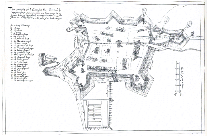
Figure 1: Mapped view of Maine depicting location of Fort St. George a.k.a the Popham colony (The Archaeology Channel, The Popham Colony Short Video Series)
Figure 2: John Hunt’s plan of Fort St. George (Wikipedia, 2023,  Image copied from http://www.pophamcolony.org/John_HuntMap.gif)

Additional Content:

Popham Colony: Planning, Attempt, and Legacy: https://youtu.be/YmmhYcaKvRs?si=SOT4c9xv5UlLtPcR

Popham Colony: A Slice of Time: https://www.mainestory.info/maine-stories/popham-colony.html

References:

Andrews, Evan. Jun. 1, 2023. “The Lost Colony of Popham.” The History Channel. https://www.history.com/news/the-lost-colony-of-popham#:~:text=One%20account%20from%20January%201608,in%20February%201608%2C%20when%20George

Beckenstein, Myron. Feb., 2004. “Maine’s Lost Colony.” Smithsonian Magazine. https://www.smithsonianmag.com/history/maines-lost-colony-106323660/

Maine Department of Agriculture, Conservation, and Forestry. 2021. “The Popham Colony of 1607.” Bureau of Parks and Lands. https://www.maine.gov/dacf/parks/discover_history_explore_nature/history/popham_colony/index.shtml

Mark, Joshua. Jan. 11, 2021. “Popham Colony.” World History Encyclopedia. https://www.worldhistory.org/Popham_Colony/

The Archaeology Channel. 2023. “ArchaeoVideo Field Communiquè: The Popham Colony, A Short Video Series.” https://www.archaeologychannel.org/video-guide-summary/119-archaeovideo-field-communique-the-popham-colony

Wikipedia. Jun. 22, 2023. “Popham Colony.” https://en.wikipedia.org/wiki/Popham_Colony#:~:text=The%20exact%20site%20of%20the,Maine%27s%20Popham%20Beach%20State%20Park.

History and Methods of Seriation

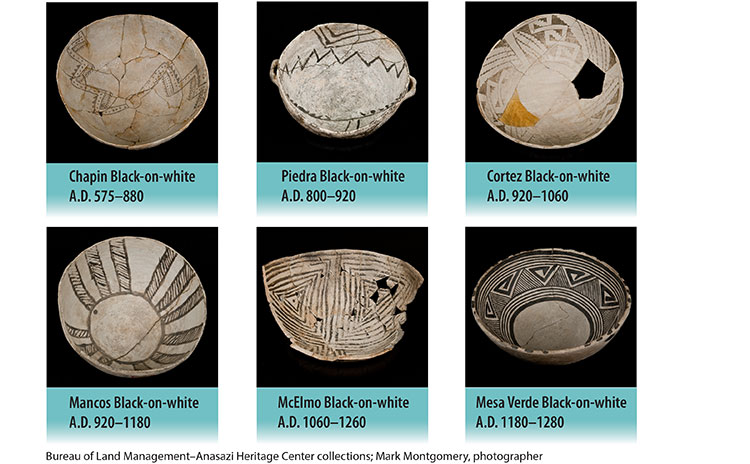
Seriation has been an archaeological tool since the end of the 19th century and the beginning of the 20th century. Seriation is known as a technique used to arrange several artifacts, sites, and/or events in a chronological sequence such that each discovery has its own timeline and identity. It is also useful to archaeologists in depicting the order of their discoveries for informational and historical use. The first and most notable person to utilize this tool was Sir Williams Flinders-Petrie. Upon discovery of several cemetery sites along the Nile River, he found that there was no efficient way to chronologically order the sites. Eventually, he discovered a number of pottery artifacts across the cemeteries. By identifying the different styles of each artifact as they were discovered, he found that the change in style was evolutionary, just as a ford automobile has had stylistic changes since the Model A in 1903. Petrie was able to revolutionize archaeology. Instead of characterizing artifacts by their design, such as “Egyptian pots”, he was able to consistently identify what period in history an artifact had come from and what those findings revealed about other artifacts buried with it or around it (Hirst 2020).

Date ranges for ancient pottery as styles develop and evolve

Seriation works because the styles of items will always evolve over time. Thus, the original technique creates an effective, yet tedious way of matching an artifact to its time period. The most conventional method of seriation involves taking samples of a dig site or junkyard and picking apart the different artifacts in the pile until what is being searched for is found in its numerous styles. This information (based on the style of each artifact and at what site it was found in) is then graphed by hand.

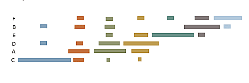
Present day seriation techniques are much more technological. Computers run matrices to depict this same data much faster, just as any analytical data technique has evolved to incorporate computers and coding. The computers generate bar graphs that show the different styles of a specific artifact that are found at different sites. A more well-known technique that has almost replaced the original methods of seriation is radiocarbon dating. Radiocarbon dating implements the organic material of an artifact instead of only dating an item based on the way it looks compared to others. Countless other dating techniques implement pieces of the methods used for seriation such as stratigraphy, typology, and even DNA analysis. Seriation is an integral part of archaeologists’ discovery procedures and has assisted archaeologists in learning more and more about human behavior and connecting the past to the present.

“Battleship curve” bar graph to show arrangement of the same type of artifact found at different lettered sites as this particular artifact evolves. (Each color represents a newer model of the item).

References:

Brauer, George. June, 2006. “An Exercise in Seriation Dating.” Office of Social Studies Baltimore County Public Schools, Towson, Maryland. https://documents.saa.org/container/docs/default-source/doc-teachingarchaeology/seriation_lesson.pdf?sfvrsn=bdae50c0_6#:~:text=This%20method%20of%20assigning%20dates,and%20then%20trails%20off%2C%20sometimes

Hirst, Kris. Aug. 27, 2020. “An Introduction to Seriation.” ThoughtCo. https://www.thoughtco.com/seriation-scientific-dating-before-radiocarbon-170607

Other links for interest:

https://www.youtube.com/watch?v=9vI6eKWK74E

https://www.digitwithraven.com/single-post/seriation