
As the western idea of a map is mostly a tool for finding one’s whereabouts and navigating to unknown places, indigenous peoples across the world have used them for purposes beyond the physical realm. Through understanding these maps from the past, archaeologists can gain a better understanding of how indigenous cultures viewed the world they inhabited and how they felt it should be represented.
Due to its ability to not decompose, art carved into rock walls such as those found in the Thebes Gap are some of the best remaining examples of these maps. Although it is highly debated amongst archaeologists, many believe that the glyph story depicted there can also locate the narrative into real places. This can be most easily proven by the pecked in dots denoting towns in clumps and pathways through lines. Out of seven formal motifs shown, the giant bird at the top seems to be most important. Seeing as it is difficult to relate this creation to Cahokia’s status in history, this creature could represent a warning to travelers of the people living ahead, or be a memory of its identity after its downfall. That is, however, if the bird represents a physical place and not one of spiritual significance and ritual creation (Norris 2008).
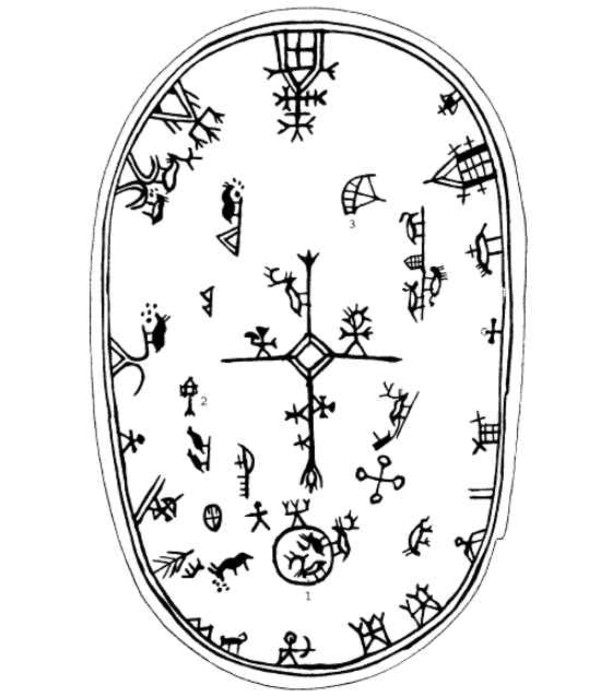
Sami Drum design, Drawing by Ville Vuolanto
Maps created by the indigenous Sami people of Lapland, in Finland, show how maps were used as a multisensory experience connecting both physical and spiritual realms. Owned and made by shamans, these maps were also functional drums. To connect to the world surrounding themselves, shamans painted what they saw onto the drum’s skin, often starting with a cross and diamond shape in the middle to depict the sun. When the Shaman slowly turns the drum while tapping different areas, it is said they could tell the different directions from just the sounds. When used in special rituals, the drum could also direct where to hunt and what would be found there, which would be recorded inside the drum which only the shaman could see (Keski-Säntti 2003). This map demonstrates how the Sami view the physical and spiritual senses as inseparable and vital parts of their lives.

“Map of the several nations of Indians to the Northwest of South Carolina.” Francis Nicholson (Contributor), c. 1721. Geography and Map Division, Library of Congress.
Furthermore, maps that focus on a political landscape have also been found, as seen in the Catawba deerskin map. Created for the governor of South Carolina around 1721 by members of the Catawba nation, this map stylistically demonstrates the relationship between different native tribes and the English settlers (St. Onge 2016). The tribe names are written within circles that are connected by a web of lines which end at the squares of settlements, all showing the trade systems of the region in an abstract sense.
These varieties of maps all show to archaeologists what each culture valued in the world around them, and what they felt was necessary to keep a record of or share with other peoples. However, as the cultures they come from have evolved or even dispersed, their functions and meaning are highly debated as they are used to study past cultures.
Further Reading
Maps, Mapmaking, and Map Use by Native North Americans
The Drum as Map: Western Knowledge Systems and Northern Indigenous Map Making
References
Keski-Säntti, Jouko, Ulla Lehtonen, Pauli Sivonen, and Ville Vuolanto. “The Drum as Map: Western Knowledge Systems and Northern Indigenous Map Making.” Imago Mundi 55 (2003): 120–25. http://www.jstor.org/stable/3594761.
Norris, F. Terry, and Timothy R. Pauketat. “A PRE-COLUMBIAN MAP OF THE MISSISSIPPI?” Southeastern Archaeology 27, no. 1 (2008): 78–92. http://www.jstor.org/stable/25746178.
St. Onge, Tim. “Celebrating Native American Cartography: The Catawba Deerskin Map | Worlds Revealed: Geography & Maps at The Library Of Congress.” Webpage, November 30, 2016. //blogs.loc.gov/maps/2016/11/celebrating-native-american-cartography-the-catawba-deerskin-map/.
Can maps be used to subvert the expectation of knowledge-production?
Yes, maps can subvert the expectations of knowledge production by presenting archaeologists with new perspectives in their research. These differing views are especially important when new interpretations and uses of knowledge are coming from the cultures they are studying themselves.