Beyond Walls: The Hopewell Earthworks in Chillicothe, Ohio

In the 1700’s Europeans were astounded at the Hopewell Earthwork in Chillicothe, Ohio (“Hopewell Mound Group”, n.d.). They were given this name due to the burial mounds in Chillicothe, later turned into a farm owned by Mordecai Hopewell (“Who Were the Hopewell?”, n.d.). The Hopewell were assumed to have built these mounds and enclosures for defense purposes, declared by an early archeologist in 1820; however, this assumption would later be dispelled (“Hopewell Mound Group”, n.d.). 

The Hopewell Mound Site could be described as a parallelogram, measuring 900 feet by 950 feet, one big circle measuring 1,050 feet in diameter, and two smaller circles of land measuring 200 and 250 feet in diameter. The wall around the parallelogram was 12 feet tall and 50 feet wide at the base. As for the circles, their walls were 5 feet high. These measurements were taken in 1848 from the remnants of the site, four miles north of Chillicothe, OH (“Archeology at Hopewell”, n.d.). Several mounds remain at the Hopewell Earthwork preserved and kept safe by its designation as a World Heritage Site (“Hopewell Ceremonial Earthworks” n.d.). However, no remnants of the walls remain on the Chillicothe land, and in the time that funds were being acquired to purchase the land by the National park Service (10 years), due to annual cultivation and the rising popularity of high-powered tractors, the mounds began to downsize (“Archeology at Hopewell”, n.n.). Over time, the walls were left to ruin too. 
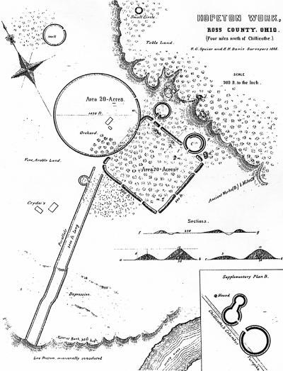
E.G. Squier and E.H. Davis rendition of the Hopeton Earthworks from 1848 (“Archaeology at Hopewell”).

Undermining the theory of defense and aversion to foreigners are the artifacts found in the Hopewell burial mounds and around the site. Most notably, were the remnants of obsidian found in the region, all traced back to Yellowstone in Wyoming (“Hopewell Culture Obsidian”, n.d.). Other artifacts found in the Scotio River Valley and the Hopewell Earthworks, were fossilized shark teeth from the Gulf Coast, jewelry made from copper and silver of the Great Lakes, and mica from the Appalachian Mountains (Langdon, n.d.). However, there was little evidence of obsidian, specifically, as one travels from Wyoming to Chillicothe, indicating that the obtainment of these materials was not through trade (Langdon, n.d.). Archaeologists believe Hopewell Earthworks to be a cultural and ritualistic center that brought people of other tribes, other cultures, and other regions on a pilgrimage-like journey similar to that which many made to Cahokia of the Mississippi (Langdon, n.d.). Thus, these walls were not created to keep people away from mounds, the presence of gates and breaks like a welcome message. The presence of foreign artifacts found buried in these mounds represents a sense of respect the Hopewell people had for those who found solace in the ritualistic center it was and for what they could provide. 
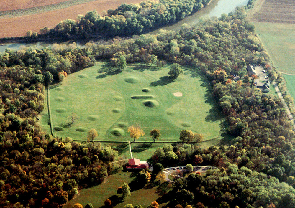
More current aerial view of the Hopewell Earthworks, designated as a UNESCO World Heritage Site (Blank 2003).

References

“Archeology at Hopewell Culture National Historical Park (U.S.” 2020. National Park Service. https://www.nps.gov/articles/archeology-at-hopewell-culture-national-historical-park.htm.

Blank, John. 2003. “Document – Mound City: Aerial View.” UNESCO World Heritage Centre. https://whc.unesco.org/en/documents/193118.

“Hopewell Ceremonial Earthworks – Hopewell Culture National Historical Park (U.S.” n.d. National Park Service. Accessed November 12, 2023. https://www.nps.gov/hocu/learn/historyculture/hopewell-ceremonial-earthworks.htm.

“Hopewell Culture Obsidian (U.S.” 2022. National Park Service. https://www.nps.gov/articles/000/hopewell-culture-obsidian.htm?utm_source=article&utm_medium=website&utm_campaign=experience_more&utm_content=large.

“Hopewell Mound Group – Hopewell Culture National Historical Park (U.S.” 2023. National Park Service. https://www.nps.gov/hocu/learn/historyculture/hopewell-mound-group.htm.

Langdon, W. n.d. “Intriguing Interactions.” National Geographic Society. Accessed November 12, 2023. https://education.nationalgeographic.org/resource/intriguing-interactions/.

“Who Were the Hopewell?” n.d. Archaeology Magazine Archive. Accessed November 12, 2023. https://archive.archaeology.org/online/features/hopewell/who_were_hopewell.html.

Bibliography

http://worldheritageohio.org/hopewell-ceremonial-earthworks/

https://www.dispatch.com/story/opinion/columns/guest/2023/10/04/hopewell-earthworks-in-ohio-is-now-world-heritage-marvel-why-it-matters/71050861007/

The Origins Of Farming

12,000 years ago hunter-gathers abandoned their long standing nomadic lifestyle and ventured towards a more efficient means of gathering food, that means came to be known as farming. (Chatterjee, 2016) 

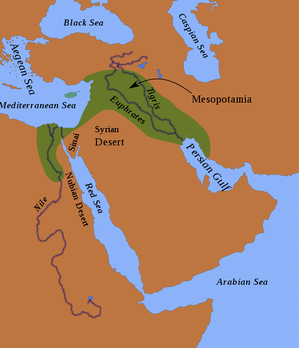
Figure 1: A map of the Fertile Crescent that includes the location of ancient Mesopotamia between the Tigris and Euphrates rivers. ( Astroskiandhike, 2018)

The Fertile Crescent, as seen in Figure 1, is a region that spans through present day Iraq, Syria, Lebanon, Israel and Jordan. The geographic features of the region allowed for the area to become a pinnacle of agricultural production dating back more than 11,000 years ago. (Chatterjee, 2016) The Tigris, Euphrates, as well as the Nile River, each traverse through the region. The convergence of these rivers helped to produce fertile soil, which is necessary for agriculture. Additionally, the rivers played an integral role in the development of irrigation, which is a necessary tool for the production of agricultural goods. Likewise, the easy access to the large waterways led to the development of trade routes. These trade routes not only transported goods and people, but also allowed for the interaction and confluence of diverse cultures and ideas. As the traders traveled back to their homeland, they transported these cultures and ideas. In essence, the Fertile Crescent become a melting pot for ideas, education and culture. These intangibles were exported along with the tangible agricultural products and goods. (Zimmer, 2016) 

Research has exhibited that no one central location in the Fertile Crescent can take credit for the invention of farming. Instead, evidence suggests that a number of smaller sites within the Fertile Crescent simultaneously practiced farming separate and apart from other groups. Researchers have examined the DNA of multiple groups that inhabited the Fertile Crescent in various locations. The DNA of individuals within those groups indicted that the groups were in no way related. Therefore, one can conclude that farming developed concurrently, at or around the same time, by various individual groups that were not interrelated. (Zimmer, 2016)   

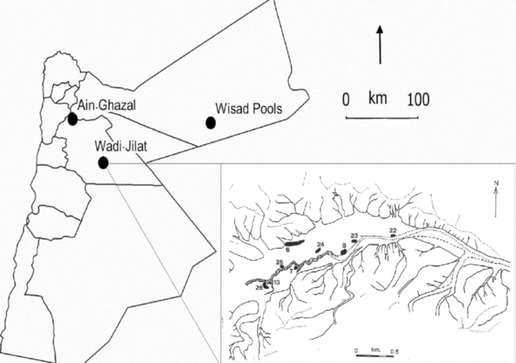
Figure 2: Map of Jordan showing locations of ‘Ain Ghazal (Andrew N. Garrard, 2019)

One of the first locations farming was found to appear was the village of Ain Ghazal. That villages that lies in central Jordan, as seen in Figure 2, which is located in the Fertile Crescent. An analysis of the site evidences the progression from a nomadic society to more agricultural based society. Specific examples of this progression can be seen in the fact that crops were raised, animals were domesticated and tools were created for farming. The farmers of the village would raise barley, wheat, chickpeas and lentils. Additionally, they would herd sheep and goats in the nearby hillsides. Another site examined was located on the coast of the Sea of Galilee. That site revealed huts that contained the remnants of 150,000 charred seeds and fruits, along with olives, almonds and grapes. Also located at the site were tools used to harvest cereals (Zimmer 2016). The totality of the findings at these sites indicate a society well on its way to transition itself from the nomadic lifestyle to an agriculturally based society. 

References:

Astrohikeandski. 2018.“File:Fertile Crescent.Svg – Wikipedia.” 2018. December 14, 2018. https://commons.wikimedia.org/wiki/File:Fertile_Crescent.svg.

Chatterjee, Rhitu. 2016. “Where Did Agriculture Begin? Oh Boy, It’s Complicated.” NPR, July 15, 2016, sec. Food For Thought. https://www.npr.org/sections/thesalt/2016/07/15/485722228/where-did-agriculture-begin-oh-boy-its-complicated.

Garrard, Andrew. 2019. “Figure 1 Map of Jordan Showing Locations of ’Ain Ghazal, Wisad Pools…” ResearchGate. August 2019. https://www.researchgate.net/figure/Map-of-Jordan-showing-locations-of-Ain-Ghazal-Wisad-Pools-and-sites-at-the-eastern-end_fig1_335515035.

Zimmer, Carl. 2016. “How the First Farmers Changed History.” The New York Times, October 17, 2016, sec. Science. https://www.nytimes.com/2016/10/18/science/ancient-farmers-archaeology-dna.html.

Further Research Links:

https://www.britannica.com/place/Ain-Ghazal

https://www.latimes.com/science/sciencenow/la-sci-sn-first-farmers-dna-20160714-snap-story.html


Food Production in Cahokia: A Parallel to Modern-Day Overconsumption

With undeniable evidence that proved that Native Americans, too, built great civilizations – achieving amazing architectural feats and forming complex societies with centralized governments – Cahokia challenged people’s preconceptions of ancient Native Americans. Contrary to popular belief, Native Americans also dealt with overpopulation and overexploitation of their natural resources. With such a massive population, which boomed around 1050 AD, Cahokia needed to produce much more food than they had before. Thanks to modern technology and advancements in archaeology, such as water flotation techniques, archaeologists are able to get better insight into Cahokia’s food production and Cahokian diet.

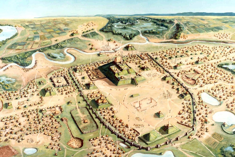
Cahokia was a highly centralized society conveniently placed in very fertile farmland (Figure 1); around the great urban center, farmers worked hard to feed the demanding population (Seppa, 1997). Cahokian rulers deliberately established the upland and bottomland farming villages. Having both upland and bottomland farming environments proved vital in food production, providing a larger variety of food and enhancing the security of food supply; if one area failed, Cahokians still had another area to draw resources from. For instance, if the bottom fields flooded, the upland fields would still thrive. On the other hand, if there was not enough rain one year, the upland fields would be too dry to sustain crops, but the bottom fields would still hold enough moisture to succeed (Tainter, 2019). 

Figure 1. An aeriel view of what Cahokia would have looked like. It shows the great urban center and the surround farming villages around it (Anwar, 2020).

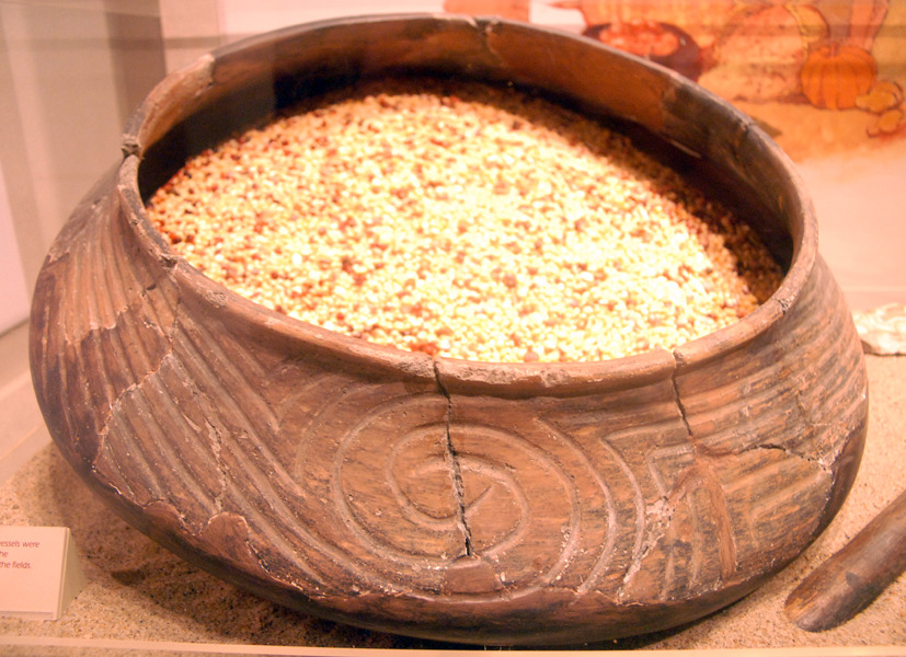
Before the rise of Cahokia, people depended primarily on diverse plant foods and consumed animals in lesser amounts. However, as the population grew, their dependence on certain foods changed. Fish, which used to be a staple food, went from 77% to 10% in consumption. Mammals, on the other hand, went from 10% to 67% in consumption, which is indicated by the increase in deer remains. The most significant staple food for the Cahokians was maize; originally domesticated in Mexico, it made its way up to the American Southwest where it became more than just a staple food – but a religiously significant crop (Tainter, 2019). Cahokians also shifted from horticulture to mass-producing agriculture. They cultivated goosefoot, amaranth, canary grass, and starchy seeds; they were able to mass produce these by storing seeds in communal granaries (Figure 2), which were uncovered during excavations (Seppa, 1997). 

Figure 2. A pot filled with seeds, which will be stored in a granary (Tumblr, n.d.).

The end of Cahokia still remains a great mystery, but it seemed to occur around the time when descendants of the upland farmers left their farms in 1150 AD, throwing Cahokia’s government and economy into turmoil (Pauketat, 2009). This goes to show how farmers were the foundation of this grand civilization. As we covered in class, the Cahokians aimed to produce the maximum to survive, which is ultimately unsustainable and is the reason for their end. This parallels overconsumption today, which is one of the biggest problems of society today. We should take our knowledge of this ancient civilization as a warning to what could happen if we continue to overexploit our resources and mass-produce. 

References:

Anwar, Yasmine. January 27, 2020. “New Study Debunks Myth of Cahokia’s Native American Lost Civilization.” Berkeley News. https://news.berkeley.edu/2020/01/27/new-study-debunks-myth-of-cahokias-native-american-lost-civilization.

Everding, Gerry. March 21, 2019. “Women Shaped Cuisine, Culture of Ancient Cahokia.” The Source.https://source.wustl.edu/2019/03/feedingcahokia/#:~:text=%E2%80%9CIt%27s%20clear%20that%20the%20vast,the%20society%2C%E2%80%9D%20she%20said

Pauketat, Timothy R. 2009. “Digging for the Goddess.” In Cahokia: Ancient America’s Great City on the Mississippi. pp. 123-128. Penguin Group: Viking Penguin.

Seppa, Nathan. March 12, 1997. “Metropolitan Life on the Mississippi.” The Washington Post. https://www.washingtonpost.com/wp-srv/national/daily/march/12/cahokia.htm#:~:text=As%20a%20corn%2Dbased%20economy,grass%20and%20other%20starchy%20seeds

Tainter, Joseph A. December 3, 2019. “Cahokia: Urbanization, Metabolism, and Collapse.” Frontiers. https://www.frontiersin.org/articles/10.3389/frsc.2019.00006/full.   

Tumblr. “Mike Ruggeri’s Ancient Cahokia.” n.d. https://mikeruggerisancientcahokla.tumblr.com/ 

Further Reading:

Chen, Angus. February 10, 2017. “1,000 Years Ago, Corn Made This Society Big. Then, A Changing Climate Destroyed It.” nprhttps://www.npr.org/sections/thesalt/2017/02/10/513963490/1-000-years-ago-corn-made-this-society-big-then-a-changing-climate-destroyed-the.

Fritz, Gayle J. Feeding Cahokia: Early Agriculture in the North American Heartland. The University of Alabama Press, 2019.

Knox, Pam. March 30, 2019. “How did Cahokian farmers feed such a large city?” UGA Cooperative Extension. https://site.extension.uga.edu/climate/2019/03/how-did-cahokian-farmers-feed-such-a-large-city/.

The Impact of Astronomy on Cahokia and Mesoamerican Societies

Throughout history, the study and interpretation of celestial bodies and movements has played a pivotal role in shaping cultures around the world. By interpreting the heavens, these civilizations have made numerous discoveries that impact the lives of everyday citizens. The influences of astronomy is reflected through agricultural practices, religious beliefs, and the establishment of societal hierarchies

In Mesoamerica, particular attention was paid to the movements of the moon and Venus, both of which were important for agricultural practices. Venus, also known as the Evening Star, was predominant in Mesoamerican cultures as its movements signified the beginning and end of the rainy seasons (Sprajc, 2011). To normal citizens, knowledge of the cosmos and the ability to predict future occurrences in the region could be interpreted as divine providence; indeed, the ability to predict celestial events may have very well been used to legitimize the privileges given to religious figures and the social elite. In turn, religious figures were likened to men-gods, who performed rituals and sacrifices to ensure the cosmos was in balance (Šprajc, 2011).

The use of astronomy to create social hierarchy is not unique to Mesoamerica. The Mississippi River civilization of Cahokia shared similar astronomical discoveries and cultural expressions with Mesoamerican civilizations. In 1961, Warren Wittry discovered Woodhenge, akin to Stonhenge in Great Britain, that acted as an observatory and calendar (Pauketat, 2010). Large poles made of a sacred wood, red cedar, ringed a central pole made of the same material. The most important of these were the poles that marked the summer and winter solstice, and the pole that marked the equinox (Keller, Young, Kronk 2022). This allowed for farmers and religious leaders to more accurately determine the best time to undertake certain activities, including the planting of crops.

Fig 1. Diagram of the woodhenge at Cahokia. This details the paths in which certain celestial events cast shadows on this monument (Crozier, 2018).

Aside from the practical applications of astronomy, the study of the heavens was also used to demonstrate status differences and religious beliefs. In Cahokia, there is a particular burial mound, designated as Mound 72, that is oriented to align with the solstices. Inside were the remains of two figures, one on top of the other, who were adorned with pelts and were buried alongside thousands of shell beads (Pauketat,  2010). The unique orientation of this mound, alongside evidence of numerous sacrifices in the area and the expensive goods in the mound, indicate that these two figures were of extreme importance.

Fig 2. Map of Mound 72 burial features at Cahokia (Thompson, Hedman, Slater, 2015).

The evidence of ritual killings in the presence of burial mounds, similar to other Mesoamerican cultures, alludes to these events being public displays of power. It is likely that, “with sacrifices, leaders could eliminate some rival claimants to office, impress the viewing public, and reaffirm the balance of the cosmos all at once” (Pauketat, 2010). Moreover, these public killings demonstrate how astronomy could influence and shape civilizations. Leaders of respective civilizations were able to utilize this valuable astronomical knowledge to establish a strict social hierarchy, and in the process, create religious justifications to reinforce their divine right to rule.

References:

Šprajc, Ivan. 2011. “Astronomy and Its Role in Ancient Mesoamerica: Proceedings of the International Astronomical Union.” Cambridge Core, Cambridge University Press. June 29, 2011. www.cambridge.org/core/journals/proceedings-of-the-international-astronomical-union/article/astronomy-and-its-role-in-ancient-mesoamerica/64F93FB7E5D1F38CCAC409DF373988A7#article

Crozier, Elizabeth. 2018. “The Stonehenge of Illinois Is a Man Made Wonder Few Know About.” OnlyInYourState®. March 21, 2018. https://www.onlyinyourstate.com/illinois/woodhenge-il/

Keller, Ken, Eric Young, Gary Kronk. 2022. “Woodhenge”. Cahokia Mounds State Historic Site and Cahokia Mounds Museum Society. https://cahokiamounds.org/explore/#tab-id-4.

Thompson, Andrew R, Kristin M Hedman, and Philip A Slater. 2015. “New Dental and Isotope Evidence of Biological Distance and Place of Origin for Mass Burial Groups at Cahokia’s Mound 72.” Wiley Online Library, July 14, 2015. https://onlinelibrary.wiley.com/doi/10.1002/ajpa.22791

Pauketat, Timothy R. 2009. Cahokia: Ancient America’s Great City on the Mississippi. Penguin Books.

Other Readings:

Aldana, Gerardo. 2022. “Maya Calendar and Mesoamerican Astronomy.” Encyclopedia of the History of Science, February 10, 2022. https://ethos.lps.library.cmu.edu/article/id/520/

Kropf, Evyn, Francesca Schironi, John Steele, Julia Falkovitch-Khain, and Pablo Alvarez. 2023. “Early Astronomy in the University of Michigan Collections.” Early Astronomy in the University of Michigan Collections | Home. https://early-astronomy.classics.lsa.umich.edu/index.php

The Pochteca: History of Trade in Mesoamerica

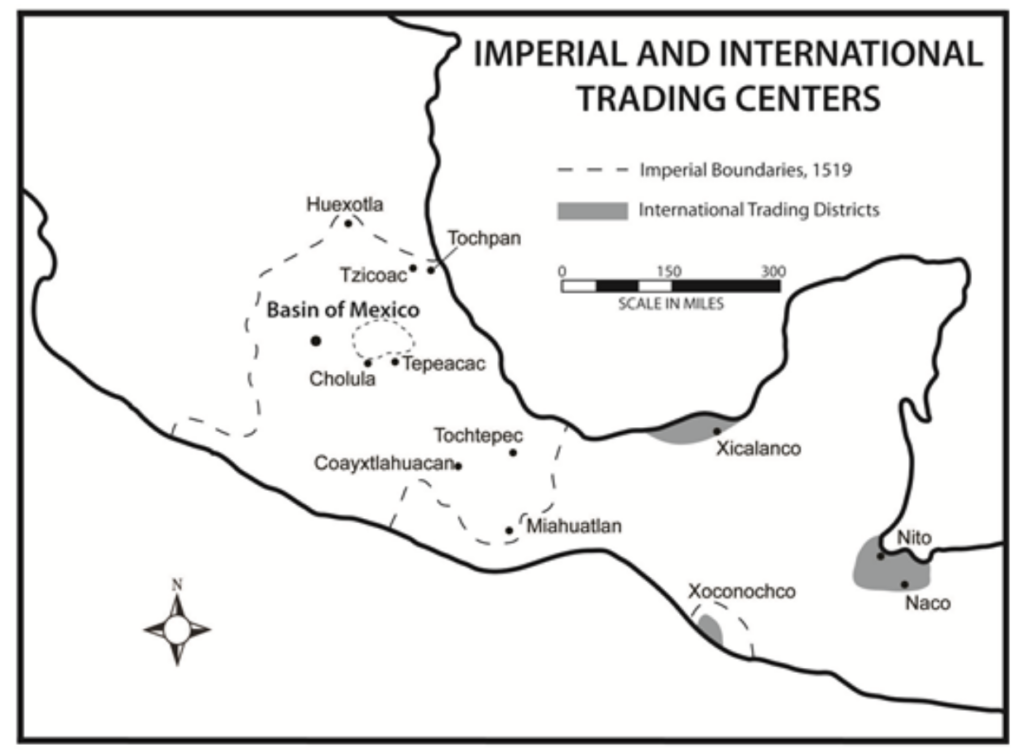
The short lived Aztec Empire was made of various city-states tied together with “persistent and aggressive multifaceted trade networks” (Berdan 2017). Although the Mexica group led the expansion of the Aztec Empire’s military and politics, they did not pioneer markets or trade in central Mexico. Evidence points to the first markets appearing in Oaxaca from 500-100 BCE, and even earlier, the first evidence of established trade networks comes from 1400-950 BCE in the preclassic Olmec civilization. Trade continued into the classical era of Mesoamerican history, as it was prominent in the Mayan world, with goods such as “obsidian, jade, quetzal feathers, marine shells, igneous rock, and various craft” (Berdan 2017) being traded. In the postclassic Aztec Empire, commerce was the primary method of integrating the various city-states comprising the empire, with trade happening locally, regionally, and foreignly throughout the region.

Fig 1: Trade in the Aztec Empire (Berdan 2017)

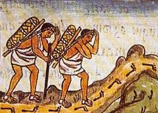
One important aspect of this far-reaching trade system were pochteca, professional long-distance traders who specialized in expensive goods such as “jaguar pelts, jade, quetzal plumes, cocoa, and metals” (Maestri 2018) and whose primary consumers were the wealthy elite. Because of their role, the pochteca had their own social class, “higher than any non-noble person” (Maestri 2018). Additionally, the pochteca guilds had their own laws, god, ceremonies, and closely guarded secrets and trade knowledge only available to sworn guild members. Pochteca traveled in caravans in every direction from their stations in major cities. They would also sometimes act as spies for their clients as marketplaces and other trade centers were good places to gather information via local gossip, which would be reported back to the buyers. Conversely, they also could be informants for the Aztec State, as their travels took them all over the empire and they had the permission to travel to foreign lands beyond control of the Mexica emperor.

Artistic rendition of the pochteca

One very important good throughout the history of Mesoamerican trade is salt. The Olmecs were the first group in the region to begin actively engaging with the material by extracting it and trading it along the eastern coast. By the classical period salt was likely one of “Mesoamerica’s most widespread regional specializations” (Williams 2009). Salt (sodium chloride) is necessary for human survival and an important tool for preserving food, and was used by the Aztec state to maintain order within the empire, as the state had the power to limit or block trade supply of the resources to conquered communities, ensuring their obedience to the empire.

References

Berdan, Frances F. “Late Postclassic Mesoamerican Trade Networks and Imperial Expansion.” Social Studies, May 2017, www.sociostudies.org/journal/articles/939197/

Maestri, Nicoletta. “Pochteca: Elite, Powerful and Deeply Distrusted Traders of Mesoamerica.” ThoughtCo, ThoughtCo, 13 Jan. 2018, www.thoughtco.com/pochteca-elite-long-distance-traders-172095

Williams, E. (2009). Salt Production and Trade in Ancient Mesoamerica. In: Staller, J., Carrasco, M. (eds) Pre-Columbian Foodways. Springer, New York, NY. https://doi.org/10.1007/978-1-4419-0471-3_7 

Further reading

Smith, Michael E. “LONG-DISTANCE TRADE UNDER THE AZTEC EMPIRE: The Archaeological Evidence.” Ancient Mesoamerica 1, no. 2 (1990): 153–69. http://www.jstor.org/stable/44478204

McGuire, Randall H. “The Mesoamerican Connection in the Southwest.” Kiva 46, no. 1/2 (1980): 3–38. http://www.jstor.org/stable/30247838

Ritualistic Caffeine Consumption in Cahokia and Beyond

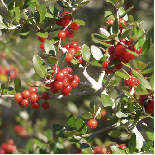
Although caffeine consumption in America is generally associated with the post-industrial world, its origins lie in Native American societies more than 900 years ago. For example, people living in Cahokia – the largest pre-Columbian city north of Mexico – frequently consumed a caffeinated brew made from the roasted leaves of the yaupon holly, a plant containing caffeine (figure 1). This dark tea, later coined “Black Drink” by European explorers, became central to Cahokian purification rituals. As noted by Euroamerican observers, these practices sought to purify the body before important events such as individual or community religious rituals, important political councils and negotiations, ball games, and war parties. (Crown et al. 2012). 

Figure 1. A photograph of a yaupon holly bush for the Florida Native Plant Society. Photograph by Shirley Denton.

Yaupon holly has a caffeine content as high as six times that of strong coffee, causing it to induce sweating. When consumed in high quantities in rapid succession, it can even lead to vomiting. As part of the purification rituals, men would likely sit in circles, sing or chant, and take turns chugging Black Drink from cups made of marine shells and vomiting. In fact, the historical use of yaupon holly to vomit is what has given it its scientific name to this day: Ilex vomitoria (Richmond 2018).  

Interestingly, Black Drink connects to our discussion of Cahokians’ interconnectedness with other Native peoples, as the holly trees from which the leaves were taken are found in the Coastal Plain of the southeastern US from Virginia to Florida and west to Texas (Crown et al. 2012). Thus, these trees were hundreds of miles away from Cahokia, requiring complex systems of trade to transport their leaves – a “level of political organization not before seen in North America” (Yates 2012). 

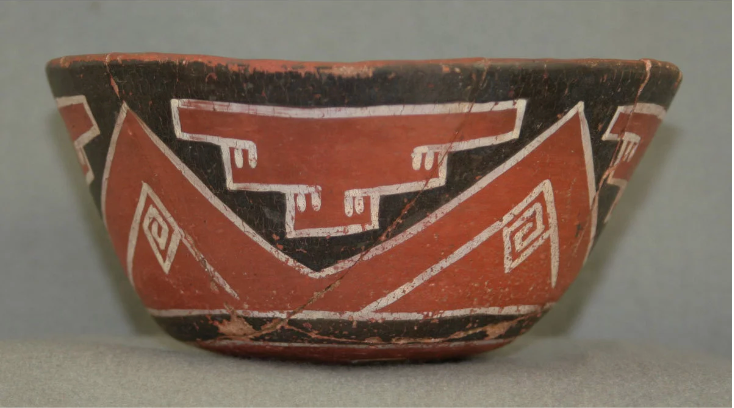
However, this practice of long distance trade wasn’t unique to the Cahokians, as various other Native American civilizations also procured holly leaves via trade, likely using them for ritualistic purposes as well. An expert in the Chaco Canyon, archaeologist Patricia Crown led a team that analyzed 177 pottery samples from 18 sites across the American Southwest and Mexico. They found caffeine residue on pieces of jars, pitchers and mugs – such as the drinking vessel shown in figure 2 – in 40 samples from 12 sites and concluded that the groups likely consumed stimulant drinks in communal, ritual gatherings (Carpenter 2015). The fact that Black Drink was not just consumed by American Southwesterners and Cahokians, but also that both groups show signs of using it ritualistically tells of a remarkably interconnected pre-Columbian North America. Perhaps along intertwining trade routes such cultural practices as purification rituals were exchanged, creating the interconnectedness that the widespread use of holly leaves suggests.

Figure 2. A drinking vessel found with caffeine residue from the Grasshopper Pueblo archaeological site in central Arizona. Photograph by Patricia Crown.

References:

  • Crown, Patricia L., Thomas E. Emerson, Jiyan Gu, W. Jeffrey Hurst, Timothy R. Pauketat, and Timothy Ward. “Ritual Black Drink Consumption at Cahokia.” Proceedings of the National Academy of Sciences 109, no. 35 (2012): 13944–49. https://doi.org/10.1073/pnas.1208404109. 
  • Richmond, Ben. “The Forgotten Drink That Caffeinated North America for Centuries.” Atlas Obscura, January 9, 2020. https://www.atlasobscura.com/articles/what-is-yaupon-tea-cassina. 
  • Yates, Diana. “Researchers Find Evidence of Ritual Use of ‘black Drink’ at Cahokia.” Illinois, August 6, 2012. https://news.illinois.edu/view/6367/205015. 
  • Carpenter, Murray. “1,000 Years Ago, Caffeinated Drinks Had Native Americans Buzzing.” NPR, September 8, 2015. https://www.npr.org/sections/thesalt/2015/09/08/437580856/1-000-years-ago-caffeinated-drinks-had-native-americans-buzzing.

Further Reading:

Flint Clay Figures and Women at Cahokia

Cahokia, the ancient city nestled in modern Illinois, was a thriving hub of early Mississippian civilization, known for its monumental earthen mounds and remarkable culture has received much attention by archaeologists. The impressive trade networks and agriculture have been extensively documented, but it’s critical to take note of the pivotal role women played in forming such a remarkable society. By examining flint clay figures found at Cahokia, along with other archaeological evidence, we can glean deeper insight into the lives of Cahokian women and the power they may have held within the farming system (Everding 19). 

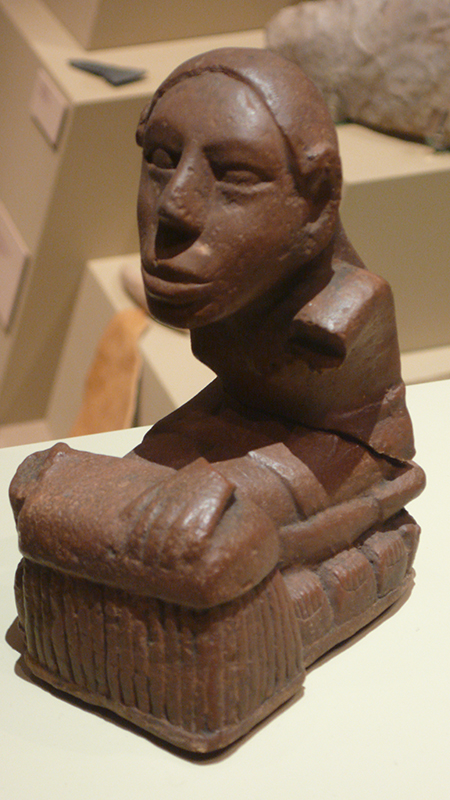
While excavating the mounds at Cahokia, archaeologists have found flint-clay statues depicting women in a distinct style to Cahokia. These figures often include plants, hoes, and other objects that represent agriculture. It’s thought that flint-clay was a rare material (Emerson & Boles 2010). The rarity of this resource is supported by the spiritually and culturally important figures that flint-clay figures show, many of whom are women. There is a woman depicted in many of these statues that has come to be known as Grandmother and Corn mother (Isselhardt 2022). Below, figure one depicts one of these statues of the Corn Goddess or Corn mother, a woman sitting upon a pile of corn cobs. Rock art from other Native American groups indicates that this figure is the same one modern Siouan speaking tribes worship (Everding 19). Archaeologists have uncovered many figures similar to this one, all expressing the same message of intrinsic female spiritual power over agriculture, and ultimately over prosperity for the society. 

Figure 1- Many scholars describe this statue, commonly known as the Keller Figurine, as a “Corn Goddess” (Vickers 2009 via Wikimedia Commons).

Some archaeologists hold that “the vast majority of Cahokia’s farmers were women” and explain that the knowledge they held of all kinds of crops solidified them in “positions of power and respect at every level of the society” (Everding 2019). It’s thought that artifacts found at Cahokia such as the flint-clay statues indicate that female farmers of Cahokia were likely praying to the often depicted Grandmother figure to aid their harvest of native grains pre-maize. Other archaeological evidence suggests the possibility that Cahokia was a matrilineal society in which women held and shared crucial knowledge through ritual feasts. (Everding 19).

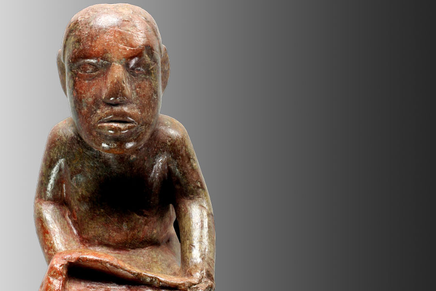
Figure 2- The Exchange Avenue figurine was found in a Stirling phase temple near the mound center (Patton 2018).

Figure two above shows The Exchange Avenue Figurine was found in a temple at the north edge of the mound center. This figure is typical of the female depictions found in excavations at Cahokia. The context of this artifact indicates that Cahokian society associated female figures with the high-status temple environments, an idea that is supported by the excavation of other flint-clay objects in similar contexts (Emerson & Boles 2010). Examining what artifacts are made of, their archaeological context, and their association with each other is critical in understanding how these flint-clay representations of women depict the broader role of women in Cahokian agriculture and society. The statues allow us to broaden our conception of the kind of work women did in ancient societies, and understand the way that women held power in Cahokia. 

Additional Reading

https://www.atlasobscura.com/articles/native-american-farming-cahokia

https://www.archaeology.org/news/3645-150828-cahokia-mound-72

Works Cited

Emerson, Thomas, & Boles, Steven   ‎‎ 2010  Contextualizing flint clay Cahokia figures at the East St. Louis Mound Center. Illinois Archaeology, 22(2), 473-490.

Everding, Gerry  ‎ ‎ ‎ 2020  Women shaped cuisine, culture of ancient Cahokia – the source – washington university in St. Louis. The Source. https://source.wustl.edu/2019/03/feedingcahokia/#:~:text=%E2%80%9CIt’s%20clear%20that%20the%20vast,the%20society%2C%E2%80%9D%20she%20said.

Isselhardt, Trinity ‎ ‎ ‎ 2022  Girlhood and the downfall of Cahokia. Medium. https://historymuse.medium.com/girlhood-and-the-downfall-of-cahokia-4cc76290830f#_edn5

Patton, Angela ‎ ‎ ‎ 2018  Exchange Avenue figurine survives to tell us about Cahokia. News. https://blogs.illinois.edu/view/7924/654280#image-1 

Vickers, Tim ‎ 2009 Keller Figurine. Wikimedia Commons. ‎ ‎ ‎https://commons.wikimedia.org/wiki/File:Keller_figurine.jpg

Ancient Mayan and Aztec Jewelry

In some Cahokian digging sites, archaeologists found maskettes and earrings made to resemble gods. Some archaeologists debate whether Cahokia was influenced by Mesoamerican societies as a lot of their legends and gods have a resemblance to one another. Not only do their gods have a resemblance, but their jewelry does too. So what did Mesoamerican jewelry look like? What did their jewelry symbolize and who could wear what?

Mayan civilization dates back as early as 1500 BCE with agriculture based on maize, squash, beans, and cassava cultivation. Along with a complex agricultural system, Mayans perfected irrigation and even had a complex hieroglyphical system of writing (Britannica.com, 2023). Even though evidence of Mayan civilization can be found around 1500 BCE, evidence of their jewelry can only be dated back approximately 5,000 years. From artifacts found, it seems as though Mayans were the masters of jewelry making. Using materials such as gold, copper, silver, bronze, and jade, their jewelry is just as complex as their agricultural and irrigation systems. Both men and women in Mayan society would wear the same jewelry aside from lip and nose plugs which were typically reserved for men with high social status. One of the most prized and sacred commodities for the Mayans was jade as they saw it as the ultimate symbol of all that is good and holy. They believed that jade represented eternal love. Religion was incredibly important to Mayan civilization which was often reflected in the jewelry they created, especially on jade beads. The Mayan elites would often present jade jewelry as gifts or as offerings to the gods. Jade jewelry would also be used as a prize in Mayan ball games. Overall, Mayans used their jewelry to show their societal status and rank (Cunha, 2021).

A jade Mayan funeral mask for King Pakal the Great, the ruler of the Mayan city of Palenque. Pakal ruled for 68 years in Palenque and transformed the city into something powerful. Jade masks like this were typically reserved for high-status, royal Aztecs and would be used to establish a relationship through the mask with the spirit world. Mask can be found in the National Museum of Anthropology (Atlas Obscura).
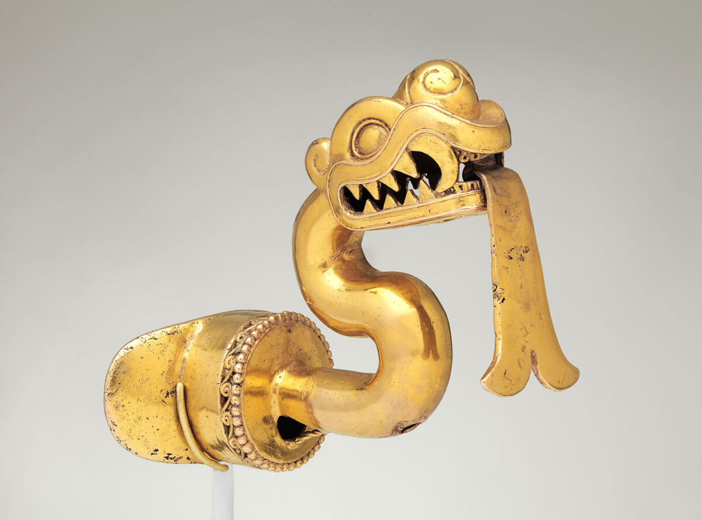
A gold Aztec labret (lip plug). These labrets were manifestations of political power and the serpent could be seen as a symbol of rulers. The design could mark this serpent as Xiuhcoatl, a fire serpent used as the weapon of the Aztec sun god, Huitzilopochtli. This labret would typically be worn on ritual occasions and on the battlefield. (The Metropolitan Museum of Art)

Throughout Aztec history, there were strict rules enforced as to who could wear what ornaments. For example, only royalty could wear certain headdresses with gold and quetzal feathers. Leather earplugs were often gifted to warriors who reached high ranks and green earrings with bells were gifted to merchants who participated in a conquest. A higher-status Aztec person would wear more and better quality jewelry than a lower-status Aztec. A wealthy Aztec might wear gold or turquoise earplugs but a lower-class Aztec would wear obsidian earplugs. Both men and women in their society would decorate themselves in bagels, chokers, and necklaces. Overall, though, Aztec jewelry had such variety and the Aztecs really perfected the art of metalworking. Because they prized metalworking so highly, most Aztec jewelry was made of gold and silver, however, they also used feathers, shells, leather, and stones for ornaments (Wikipedia.org, 2023). Bells were a popular style in Aztec society and they were often fashioned to look like little flowers. These bells would often be hung from necklaces or earrings. These metalworkers and craftsmen would dedicate their lives to the craft. Like the Mayans, they would also use religion and symbolism in their jewelry (Aztec-history.com).

References:

Additional Reading:

The Creation and Use of Shell Beads in Cahokia

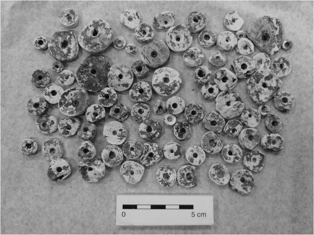
In the book we’re reading on Cahokia, Timothy R. Pauketat spends a lot of time on the human sacrifices and burial rituals that were so prevalent in the city. What stood out to me was the way that important men were buried, specifically the beads so present in their burial mounds. Pauketat describes the “beaded burial” (Pauketat, 73) of two important men. Their bones were wrapped in cloth and placed on top of animal pelts and thousands of shell beads sewn onto a now-decomposed piece of fabric. This made me very curious about the significance of beads in Cahokia, as well as where they came from and how they were modified.

Beads from the “beaded burial” (Kozuch).

The “beaded burial” site can shed a lot of light on the importance of beads. Shell beads were likely used as a marker of status, seeing as “over 32,700 columella beads … from Mound 72 were associated with high status women,” and “most LW [abbreviation of lightning whelk] beads were buried with mound mortuaries … associated with higher status individuals” (Kozuch, 65). There is also earlier research stating that marine shells were likely reserved for only the highest class citizens (Holley, in Kozuch, 67). It’s very interesting to reflect on how items that are currently seen as worthless were once so important. The city of Cahokia, including the greater surrounding area, had many bead-crafting workshops. These could be identified through specific tools that would’ve been used to form shells into beads (Mason, Perino, and Morse, in Kozuch, 67). The existence of these bead workshops, and the thousands upon thousands of beads used in burials, indicate that Cahokians saw beads as a symbol of status and wealth, much as modern society views precious gems. However, it wasn’t as if shells were reserved for only the rich. There was a large “presence of marine shells at non-elite Mississippian residences” (Prentice, 207). To me, this could create a hierarchy of beads: rare ones such as the lightning whelk shells were owned by elites, while common ones were dispersed among the masses. This makes sense, considering Cahokia’s proximity to the Mississippi river, but conflicts with Holley’s earlier research that says the opposite.

“Cahokia bead workshops and mounds with beads. 1 Kunnemann Tract and Mounds, 2 Groves Borrow Pit, 3 Powell Mound, 4 Fingerhut Tract, 5 Dunham Tract, 6 Tract 15B, 7 Ramey Tract, 8 Wilson Mound, 9 Mound 72.” (Kozuch)

The abundance of shells and the many bead workshops at Cahokia made me a bit curious about trade in the region. It is clear that trade routes existed in the ancient Americas, and shells were transported along these routes (Prentice, 200). Many theories exist, including ones about shells being used as money or being traded at set prices (Prentice, 200 – 207), but these are unproven. Seeing as Cahokia was such a large city and important trading center, it is an understandable conclusion that some level of shell trade took place.

Reference list:

  • https://journals.sagepub.com/doi/full/10.1177/01976931211048205
  • https://www.jstor.org/stable/20708256?seq=1

Additional reading:

  • https://www.washingtonpost.com/wp-srv/national/daily/march/12/cahokia.htm
  • https://news.illinois.edu/view/6367/391694

Cahokia and its Waterways

Grace Hill

A point of Timothy R. Pauketat’s writing of Cahokia: Ancient America’s Great City on the Mississippi that sticks out to me is highlighted in it’s title: Cahokia’s positioning along the Mississippi river. Specifically, what interested me, is how this alignment along waterways has added to the growth of Cahokia itself, as well as the establishment of food and crop production, travel, trade, and is suggestive toward the importance of waterways in major U.S. cities today. 

Throughout Timothy R. Pauketat’s text on the ancient indigenous civilization of Cahokia, the settlement’s location along the Mississippi River is also consistently mentioned. Specifically, Cahokia had an interesting placement near the junction of the Mississippi river, Missouri river, and parts of the Illinois rivers. Pauketat acknowledges the benefits of this proximity to vital and flourishing water sources in ancient Cahokia in various ways. On page 139 of “Cahokia,” for example, Pauketat mentions how Cahokians might have used the Mississippi and Missouri rivers as routes for trade, raiding or interaction with other communities along the waterways (Pauketat 2009:139 ?). Page 18 also briefly mentions agriculture production along the Mississippi (Pauketat 2009:18). Despite Pauketat’s brief descriptions of these points, they are not to be ignored. Cahokia’s geographic positioning along North America’s waterways goes hand-in-hand with the civilization’s cultivation of power and steady growth into one of Ancient America’s most astounding civilizations. 

Cahokia’s position on a map.

Similar to Pauketat’s brief descriptions of the importance of the surrounding rivers on the Cahokia civilization, the Mississippi river has had ties to many Indigenous nations and groups throughout American history. According to Northern Illinois University, “The Choctaw, Chickasaw, Quapaw, Osage, Caddo, Natchez, and Tunica” (Burton et al.) were among the many groups who aligned themselves along the Mississippi river throughout generations. This alignment to these bodies of water would have put Native communities into direct contact with each other, as well as European settlers and traders in the late seventeenth and early eighteenth centuries (Burton et al.). Alignment along the flourishing Mississippi river created distinct lines of trade and commerce, be it for better or for worse. It is interesting to think about how Cahokia’s positioning close to this waterway hundreds of years earlier, in addition to its proximity to the Missouri and Illinois rivers, would have created vital passages to neighboring communities and trade routes, along with the other benefits of proximity to flourishing bodies of water.  

In addition to the indigenous presence along the Mississippi river, it is interesting how the presence of waterways in various civilizations has evolved many major, bustling cities of today. New York City, San Francisco, and Chicago are among the multitude of cities that have grown out of a long history of trade, commerce, and agriculture along rivers and oceans. St. Louis, itself, was born out of almost the exact geographical positioning as Cahokia, along the junction of three of America’s most important waterways. 

A map of the Mississippi river and it’s extending waterways.
The Mississippi River.

Works Cited

Burton, Vernon, et al. “Forced Over the Great River: Native Americans in the Mississippi River Valley, 1851-1900.” Mark Twain’s Mississippi, Northern Illinois University Digital Library, N/A, https://digital.lib.niu.edu/twain/forced. Accessed 4 November 2023.Pauketat, Timothy R. Cahokia: Ancient America’s Great City on the Mississippi. Viking, 2009.

Additional Links:

https://www.washingtonpost.com/wp-srv/national/daily/march/12/cahokia.htm

https://www.americanrivers.org/river/missouri-river/#:~:text=America’s%20Longest%20River&text=Louis%2C%20forming%20the%20world’s%20fourth,people%20over%20thousands%20of%20years.