Cahokia and its Waterways

Grace Hill

A point of Timothy R. Pauketat’s writing of Cahokia: Ancient America’s Great City on the Mississippi that sticks out to me is highlighted in it’s title: Cahokia’s positioning along the Mississippi river. Specifically, what interested me, is how this alignment along waterways has added to the growth of Cahokia itself, as well as the establishment of food and crop production, travel, trade, and is suggestive toward the importance of waterways in major U.S. cities today. 

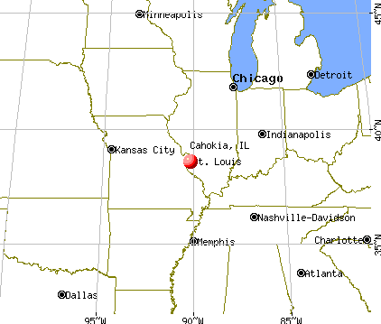
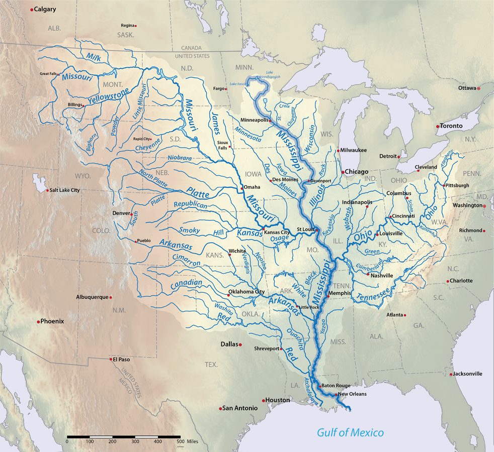
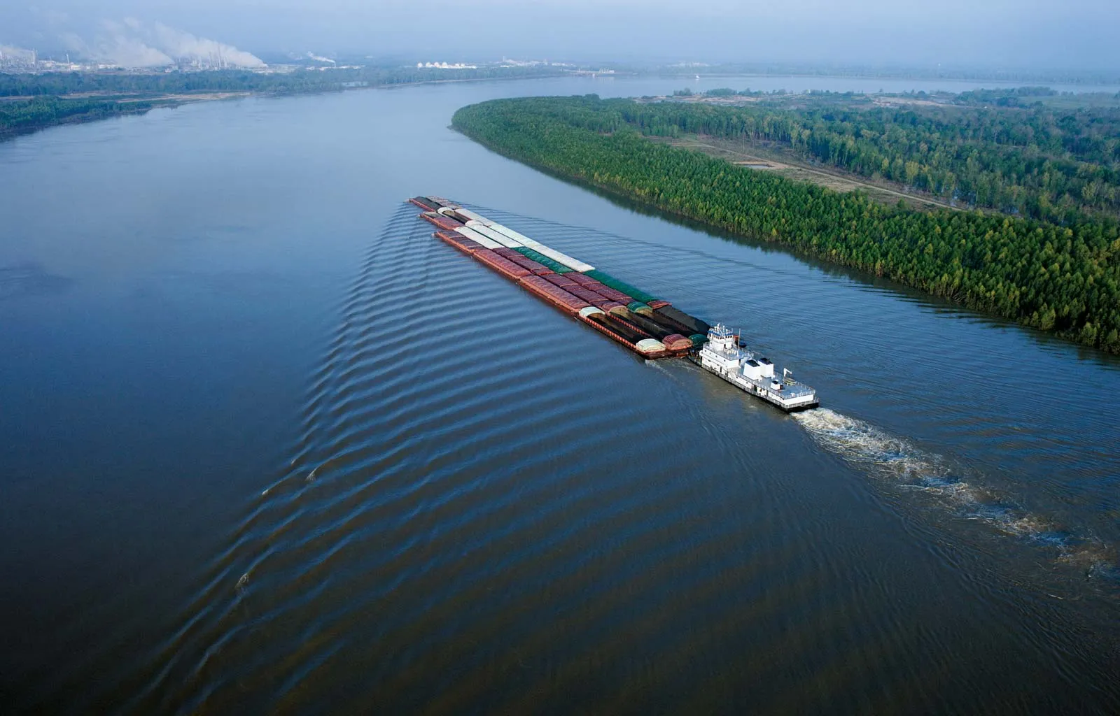
Throughout Timothy R. Pauketat’s text on the ancient indigenous civilization of Cahokia, the settlement’s location along the Mississippi River is also consistently mentioned. Specifically, Cahokia had an interesting placement near the junction of the Mississippi river, Missouri river, and parts of the Illinois rivers. Pauketat acknowledges the benefits of this proximity to vital and flourishing water sources in ancient Cahokia in various ways. On page 139 of “Cahokia,” for example, Pauketat mentions how Cahokians might have used the Mississippi and Missouri rivers as routes for trade, raiding or interaction with other communities along the waterways (Pauketat 2009:139 ?). Page 18 also briefly mentions agriculture production along the Mississippi (Pauketat 2009:18). Despite Pauketat’s brief descriptions of these points, they are not to be ignored. Cahokia’s geographic positioning along North America’s waterways goes hand-in-hand with the civilization’s cultivation of power and steady growth into one of Ancient America’s most astounding civilizations. 

Cahokia’s position on a map.

Similar to Pauketat’s brief descriptions of the importance of the surrounding rivers on the Cahokia civilization, the Mississippi river has had ties to many Indigenous nations and groups throughout American history. According to Northern Illinois University, “The Choctaw, Chickasaw, Quapaw, Osage, Caddo, Natchez, and Tunica” (Burton et al.) were among the many groups who aligned themselves along the Mississippi river throughout generations. This alignment to these bodies of water would have put Native communities into direct contact with each other, as well as European settlers and traders in the late seventeenth and early eighteenth centuries (Burton et al.). Alignment along the flourishing Mississippi river created distinct lines of trade and commerce, be it for better or for worse. It is interesting to think about how Cahokia’s positioning close to this waterway hundreds of years earlier, in addition to its proximity to the Missouri and Illinois rivers, would have created vital passages to neighboring communities and trade routes, along with the other benefits of proximity to flourishing bodies of water.  

In addition to the indigenous presence along the Mississippi river, it is interesting how the presence of waterways in various civilizations has evolved many major, bustling cities of today. New York City, San Francisco, and Chicago are among the multitude of cities that have grown out of a long history of trade, commerce, and agriculture along rivers and oceans. St. Louis, itself, was born out of almost the exact geographical positioning as Cahokia, along the junction of three of America’s most important waterways. 

A map of the Mississippi river and it’s extending waterways.
The Mississippi River.

Works Cited

Burton, Vernon, et al. “Forced Over the Great River: Native Americans in the Mississippi River Valley, 1851-1900.” Mark Twain’s Mississippi, Northern Illinois University Digital Library, N/A, https://digital.lib.niu.edu/twain/forced. Accessed 4 November 2023.Pauketat, Timothy R. Cahokia: Ancient America’s Great City on the Mississippi. Viking, 2009.

Additional Links:

https://www.washingtonpost.com/wp-srv/national/daily/march/12/cahokia.htm

https://www.americanrivers.org/river/missouri-river/#:~:text=America’s%20Longest%20River&text=Louis%2C%20forming%20the%20world’s%20fourth,people%20over%20thousands%20of%20years.

Stratigraphy in Archaeology and The Grand Canyon

Friday, September 16th, my group of classmates finished our fieldwork at the Kimlin Cider Mill and the remains of its horse-drawn cider press. The old mill served as a popular café destination for Vassar students of the early 1900s—our class returned to the mill to search for any signs of its historical mill or any material that would have pointed towards life in the early 20th century. We used methods of stratigraphy and other archaeological survey systems to do so, recording our observations in each 10 cm increment we created below the sod. After a while, we could see how the layers slowly began to change in soil makeup and earth density, as well as the age of artifacts we found. This method of layered ground work that we performed at the old cider mill was especially interesting to me, as it felt like a direct representation of the readings in our class textbook, and also made me question other areas of stratigraphic surveying and the history revealed beneath our feet. Our combined reading and layered ground work reminded me of the ancient sedimentary layers of the Grand Canyon, which stuck out to me when I visited the national park as a child. 

Sedimentary Layers

The Grand Canyon’s ancient and distinct layers of rock are some of the world’s clearest examples of prehistoric sedimentation. The canyon’s strata is separated into various ages and subgroups, which formed on top of each other over millions of years of erosion and sediment build up, creating the sharp lines seen in the image above. According to the Grand Canyon’s National Park services, the oldest of the Canyon’s visible rock layers are up to 1,840 million years old (Mathis, Bowman). The Grand Canyon’s rock stratification is significant because of its visual representation of archaeological and geological site history. Just by viewing the Canyon’s rock features, one is looking hundreds of millions of years into the past. 

Grand Canyon’s Sedimentary Layers & Age Groups

Apart from the Canyon’s Geological stratification, the National Park is home to an extensive amount of human history and ancient relics. Up to eleven Native American groups have been associated with the Canyon over thousands of years. Among the remains of ancient Native American living spaces and stone houses, artifacts of pottery, tools and small animal figurines are among the most interesting of the Grand Canyon’s hidden relics (“Archaeological Resources”). I was reminded again of our fieldwork which brought us face-to-face with forgotten objects hidden below ground. 

Completing my fieldwork by observing layers of the ground below us helped me better understand some of our world’s most important examples of geological history. My connection with our class fieldwork and the Grand Canyon helped me connect our textbook definitions of archaeology to real world examples, and encouraged me to look deeper into the archaeological history of one of America’s most famous natural sites. After our fieldwork and my research on the Grand Canyon’s ancient sedimentary layers, I was able to put value to the phrase, ‘the deeper you dig, the older things get.’

Works Cited

“Archaeological Resources – Grand Canyon National Park (U.S.” National Park Service, https://www.nps.gov/grca/learn/historyculture/arch.htm. Accessed 17 September 2023.

Mathis, Allyson, and Carl Bowman. “Telling Time at Grand Canyon National Park (U.S.” National Park Service, 25 April 2018, https://www.nps.gov/articles/age-of-rocks-in-grand-canyon.htm. Accessed 17 September 2023.

Additional Resources:

“Grand Canyon Geology”

“Whose Land Am I On? Native American Tribes in the Grand Canyon”