Respect for the dead has proved to be a prevalent notion in most cultures. However, prior to the development of modern Egyptology and the transformation of archaeologists from antiquarians to scientists, desecration of burial sites and dead bodies was not only common, but in the case of Egyptian mummies, used as a form of entertainment.
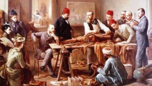
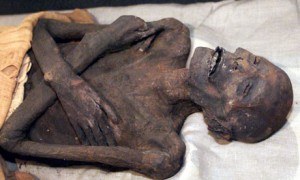
 During the late 18th and early 19th centuries, “Egyptomania,” a fascination with ancient Egypt, swept over Europe. While many important discoveries about the Egyptians occurred during this era, wealthy amateur “Egyptologists” and collectors did much damage. Tombs were raided and mummies were sold cheaply to European enthusiasts for a variety of purposes. Best case scenario, the mummy served as a collector’s piece, providing little historical information but also oftentimes avoiding destruction. However, many mummies met a much worse fate. Some were boiled, and the oil produced was sold as a medical ointment. Others were publically unwrapped, both in educational settings and during what have come to be known as mummy unwrapping parties. At these parties, wealthy Victorian Egyptology enthusiasts would unwrap ancient mummies under the guise of science, and often give away the artifacts that were buried with them as party favors. While these parties serve as a rather extreme example, they demonstrate the danger of pseudoarcheology and the lack of respect that many Western nations showed for the human remains of non-European cultures.
The first major step towards putting an end to desecration of Egyptian artifacts occurred in 1859, when Auguste Marlette, an Egyptologist, founded the ESA (Egyptian Service for Antiquities), which was designed to protect and preserve valuable pieces of Egyptian history. Since then, more action has been taken by archaeologists, Egyptologists, and the Egyptian government to put a stop to desecration of mummies. These measures ensure that the past is well preserved, but they also raise the issue of respect for human remains. Who has the right to uproot and examine the body of another human being? What level of respect must scientists and archaeologists show towards the remains that they study? Does ethnocentrism play a major role in the amount of respect given to said remains? This issue is prevalent in American archeology as well, concerning remains of Native Americans that are considered sacred by many of their descendants. The problem of desecration is one that must be addressed by archaeologists worldwide.
Works Cited:
“Egyptian Mummies | Ancient Egyptian Mummy Overview.” Egyptian Mummies | Ancient Egyptian Mummy Overview. N.p., n.d. Web. 27 Oct. 2013. <http://www.kingtutone.com/mummies/overview/>.
“Egyptomania.” Wikipedia. Wikimedia Foundation, 24 Aug. 2013. Web. 27 Oct. 2013. <http://en.wikipedia.org/wiki/Egyptomania>.
“The Neo-Victorian Parlour.” : Victorian Mummy Unwrapping Parties. N.p., n.d. Web. 27 Oct. 2013. <http://neovictorianparlour.blogspot.com/2013/04/victorian-mummy-unwrapping-parties.html>.
“Unwrapping the Mummy Performance and Science.” Unwrapping the Mummy Performance and Science. Past Horizons, n.d. Web. 27 Oct. 2013. <http://www.redicecreations.com/article.php?id=22957>.
Images:
http://www.redicecreations.com/ul_img/22956unwrapparty.jpg
http://www.theguardian.com/artanddesign/artblog/2008/may/23/maevkennedyfriampic


