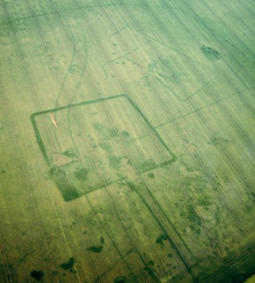
It’s a bird! It’s a plane! It’s aerial survey archaeology!
Aerial photography, the most common type of aerial survey, has revolutionized the archeological community over the past hundred years. The seed was planted in 1858, when Gaspard Felix Tournachon took the first recorded aerial photograph from a hot air balloon. His plan was to use the photos to create maps, but the idea of aerial survey began to circulate, and the first aerial pictures of Stonehenge were taken in 1908. With the onset of World War I, Europe experienced a significant advance in aviation technology, and archaeologists began to fully realize aerial photography’s potential to revolutionize the field.
Aviation technology has made leaps and bounds since 1918, and so has aerial photography. Today, archaeologists divide photos into two distinct categories: vertical and oblique. Vertical photos are taken at high levels, usually from planes, while oblique photos are most commonly taken closer to the ground, with handheld cameras. Within these types, there are three stages in the process of aerial photography. First, the archaeologist takes the pictures, which is called reconnaissance. Then, he or she looks at other surveys of the same land to identify changes in the landscape. This is called the archive search. Finally, comes the mapping stage, in which he or she interprets the information gained from the aerial photographs.
So, why do we need aerial survey? What can it tell modern archeologists that surface survey and excavation cannot? Aerial photography is crucial when it comes to identifying burial mounds or other surface characteristics not necessarily visible to someone on the ground. In addition, archaeologists can use it to detect the presence of demolished houses or buildings by observing “soil marks” (distinct coloration of the soil as a result of past archaeological features). The presence of subsurface archaeological remains can also change the color and height of crops. These “crop marks” are another way that archaeologists can gain evidence about what lies below the surface of the site prior to the excavation. 
Non-photographic aerial survey is also useful, because it employs tools such as radar and thermography to penetrate vegetation, and detect archaeological features based on their temperature in relation to the soil.
Aerial survey has revolutionized the field because it allows modern day archaeologists to get a sense of the layout of their sites before excavation, or even surface survey begins. Additionally, it provides many clues about potential features that surface survey cannot. But most importantly, aerial survey injects a sense of the big picture into a field dominated by minute details. While these tiny pieces of evidence are crucial during surface survey and excavation, a larger perspective, or a bird’s eye view in this case, can make all the difference in understanding the past.
Works Cited:
“AARG: Short Introduction to Aerial Archaeology | Aerial-Archaeology.” XML. AARG, n.d. Web. 28 Sept. 2013. <http://www.univie.ac.at/aarg/php/cms/Aerial-Archaeology/short-introduction-to-aerial-archaeology>.
“Aerial Photography.” Learning Archaeology: Pre-Ex:. Past Perfect, n.d. Web. 28 Sept. 2013. <http://www.pastperfect.org.uk/archaeology/aerialphoto.html>.
“Aerial Survey for Archaeology.” English Heritage Home Page. N.p., n.d. Web. 28 Sept. 2013. <http://www.english-heritage.org.uk/professional/research/landscapes-and-areas/aerial-survey/archaeology/>.
Sharer, Robert J., and Wendy Ashmore. Archaeology: Discovering Our past. Mountain View, CA: Mayfield Pub., 1993. Print.
Images:
http://www.armadale.org.uk/viladonga.jpg
http://www.corpusetampois.com/che-21-francoisbesse2006mespuits1a.jpg
Further Reading:

This is why I always get a window seat on a flight.
Aerial photography, despite its long history, shows even more promise for archaeological study with the incorporation of modern technology, such as radar and thermography. As you rightly pointed out, aerial survey can give critical information about sites that would not have been as evident on the ground, as well as giving a sense of scale to the area. Aerial survey can also aid in forensic work; for example, aerial photography was instrumental in the clean-up after Hurricane Katrina. Aerial survey can also aid in the study of environmental phenomena, such as erosion, vegetation distribution, wildfires, and the health of flora and fauna. There are several groups that deal exclusively with aerial documentation for archaeological study and disaster relief; for more reading, check out the Conservation Air Patrol, who use aerial survey to aid in disaster relief and research environmental science: http://www.conservationair.org/index.php?id=393
This page definitely has all the info I wanted concerning this subject and didn’t
know who to ask.