Unearthing Treblinka: Archaeology as a Tool to Restore Memory

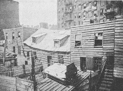
During WWII, over 900,000 Jewish deportees were killed and buried at the Treblinka death camp in Poland. The Nazis left Treblinka in 1943, but not before knocking down all buildings and leveling the earth. They then built a farmhouse on the stripped land, planted trees, and installed a Ukrainian farmer on the area. An investigation of German crimes in 1946 found the remains of burnt posts, foundations of a building and well, and sections of paved road. The investigation also discovered human remains buried in the ground. However, none of this information alluding to the site of a mass murder was reported to the public. Despite witness testimonies supporting the concept of a mass grave at Treblinka, the reported lack of physical evidence failed to produce further investigation.

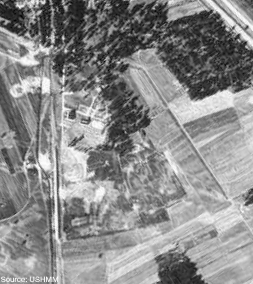
This aerial photo from 1943 following Treblinka’s closure shows an empty area of land, apart from the farmhouse at top left. Archaeologists have found that the farmhouse was in fact constructed using bricks from the dismantled gas chambers.

These German crime investigation reports remained the most complete studies of Treblinka until 2010, when a team of archaeologists began working on the area. In order to respect Jewish law and tradition banning the exhumation of the dead, they did not excavate the area. Instead, the team uses noninvasive technologies such as aerial photography, ground-penetrating radar, GPS, and lidar. These methods have identified the traces of probable undressing barracks, gas chambers, and burial/cremation pits. One of the burial pits found was recorded as 26 meters long, 17 meters wide, and 4 meters deep. Five more pits of similar sizes are located nearby, each revealing the massive scale of the atrocities committed at the site.

Surface survey has also found items on the ground surface at Treblinka, including human bone, which correlates to witness testimonies of improvised cremation methods. According to survivors, the camp did not decide to cremate bodies until it had been open for several months, and due to a lack of a purpose-built crematorium, they began burning bodies on makeshift pyres. These cremation results would not have eradicated bone, which has resulted in the presence of bone fragments at the site. Personal and everyday items have also been found at the site by means of surface survey.

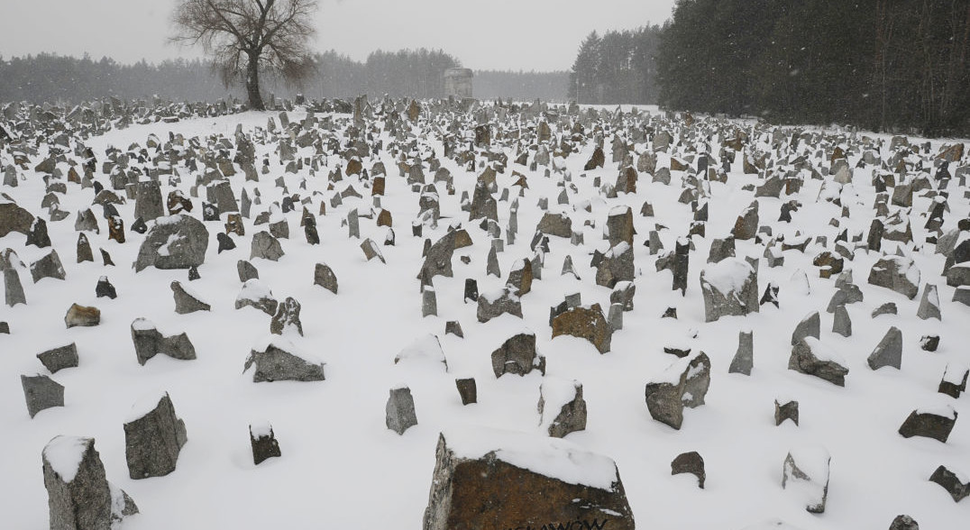
A photo of the current memorial at Treblinka commemorating the 900,000 Jewish people who were killed at the site.

Treblinka was not the only death camp left empty by the Nazis. Two other camps in Poland, Bełżec and Sobibór, were also razed completely after their closures. For this reason, these camps have receded into the historical background compared to Auschwitz, which was discovered with gas chambers still standing and thousands of prisoners still alive. The Nazis also destroyed all written records, leaving the only source of evidence of the mass murders at these sites as witness testimony. Until this project, it seemed that Treblinka and its memories had been wiped off the face of the earth. The work of the archaeological team at this site demonstrates the power of archaeology to at least partially bring back lost knowledge and memory. The team is planning on long-term collaboration with the Treblinka museum in order to continue unearthing new physical evidence at the site and to allow the victims to be properly commemorated.

Sources:

http://www.bbc.com/news/magazine-16657363

http://www.sapiens.org/archaeology/the-darkest-truths/

https://www.scientificamerican.com/article/unearthing-the-atrocities-of-nazi-death-camps/

Images:

http://www.bbc.com/news/magazine-16657363

http://www.sapiens.org/archaeology/the-darkest-truths/

Further Reading:

http://www.smithsonianchannel.com/shows/treblinka-hitlers-killing-machine/0/3403868

http://www.tandfonline.com/doi/abs/10.1179/1574077312Z.0000000005

Archaeology of Japanese Internment Camps

Shortly after the attack on Pearl Harbor, president Franklin D. Roosevelt signed executive order #9066, authorizing the internment of Japanese Americans. Between 110,000 and 120,000 people of Japanese descent, 62% of whom were citizens, were displaced, mainly to 10 centers in the western interior of the US.

Locations of internment camps, here called “Relocation Centers”

After WWII, most of the structures of the camps were dismantled, leaving little left to see to the untrained eye. To the archaeologist, however, the seemingly barren site contains invaluable information waiting to be uncovered through the examination of foundations, artifacts, trash pits, and landscape features. Archaeological excavations at the sites revealed, among other things, foundations of buildings, remnants of guard towers and fences, latrines, ceramics, Japanese games such as Go, and Japanese- style gardens. These artifacts tell stories about the daily lives of internees that are often left out of official histories and give a glimpse into how the people survived, both physically and emotionally.

The archaeology reveals that the camps’ inhabitants resourcefully found ways to make their environments more familiar and habitable. Traces of Japanese-style rock alignments, walkways, gardens, and ponds remain. In Amache, a camp in Colorodo, there is evidence that the internees repurposed water pipes as planters, used copper wire to train Chinese elms, and made the desert soil more fertile by adding eggshells, enabling them to grow traditional foods. The innovative ways in which the Japanese modified the landscape to reflect their cultural values shows a resistance to a government and an institution that tried to strip them of their heritage.

Remains of a Japanese garden created by internees at Manzanar.

The large quantities of Japanese china and ceramics also show how the internees tried to maintain their cultural identities. Often, people were only allowed to bring what they could carry, so the presence of so many ceramics shows the importance of these items as a reminder of home, as tangible evidence linking them to who they used to be.

The evidence also helps to dispel pervasive myths and misconceptions about the camps. Some residents living near the camps, and others throughout the country, denied that there were guard towers or fences surrounding the camps and asserted that the inmates were “coddled” while other Americans suffered shortages and rations. The evidence once and for all proved these claims to be false.

In this case, archaeology can have a healing effect and provide a sense of closure and, perhaps most importantly, provide validation to those who were interned. It is important that this moment in history is remembered so that the same mistakes are not made in the future. Although the US has acknowledged that the internment camps were not based on military necessity but on prejudice and wartime hysteria, this dark moment of US history is not discussed as much as it should be. Hopefully the excavations can bring Japanese internment into the public conversation and illustrate that the issues that lead to it are still relevant and prevalent today, as racism, ethnocentrism, and balancing civil rights with national security continue to challenge the country.

Sources:

Additional Reading

Impact of the Nile River on Ancient Egypt

In the thousands of years after the end of the last Ice Age, North Africa had a much wetter climate than it does today. Over time, the climate became drier as the wetlands turned into the Sahara Desert we know today. The land became dry and difficult for human societies to live in. In the midst of the desert, however, was a flowing river called the Nile.

The Nile supported and allowed life to thrive in the grueling climate. The earliest inhabitants along the river found that the river provided many sources of food, and more importantly, discovered an annual 6 month period where the Nile flooded. The brown layer of silt that the Nile left when it receded was full of nutrients that allowed for farming to occur. Through the use of irrigation canals, agriculture was born which paved the way for the emergence of Egyptian civilization.

This painting depicts the vitality the Nile River brings to the arid climate. Without it, Egyptian civilization could not have existed.

The inhabitants utilized the Nile to adapt to the changing environment. Instead of roaming the land, they saw the opportunity the Nile provided them through agriculture. Similar to how the Mayans developed Neolithic techniques through maize, beans, and squash in the tropical climate of Guatemalan rainforests, early Egyptians were able to grow wheat, beans, and cotton on the banks of the Nile. By determining when the Nile flooded, the river proved to be a sustainable way to live life.

The flooding of the Nile was not a perfect occurrence. This gave rise to the belief in the gods and a highly stratified social structure. At the top of the social structure were gods such as Ra and Osiris because the Egyptians believed that they controlled the universe. The Egyptians tried their best to please the gods because if they were happy, then the Nile would flood producing an abundance of crops and preventing famine. After the gods came the pharaohs in social status. The Egyptian people believed the pharaoh to be a god in mortal form. They had absolute power over the dominion which required protection through the help of government officials and soldiers. The rest of the people’s status went in the order of scribes, merchants, artisans, farmers, and finally slaves.

This wall painting depicts the King Tutankhamen with Egyptian gods Anubis and Nephthys. King Tutankhamen ruled from 1333- 1323 BCE.

This social stratification was necessary for a civilization as large as ancient Egypt to function. Slaves were utilized to build infrastructure, farmers produced the food for the society, and the other social levels contributed by either governing, defending, or producing commodities for the civilization. Social mobility was possible in ancient Egypt though. Sending sons to schools to learn how to read and write could make it possible for them to become a scribe, boosting social status.

Ancient Egyptian civilization was created and greatly influenced by the Nile River. The flooding of the Nile was sustainable but not perfectly reliable, creating the belief in gods and social stratification. The Nile River provided sustenance to Egypt for around 3000 years. In 332 BC, Alexander the Great conquered Egypt and Ptolemaic period of Macedonian rule began.

Sources:

http://www.ushistory.org/civ/3b.asp

http://www.ushistory.org/civ/3a.asp

http://www.timemaps.com/ancient-egyptian-history-3500bc

Images:

http://egyptiansyear4.weebly.com/the-uses-of-the-river-nile.html

http://www.history.com/topics/ancient-history/ancient-egypt/pictures/egyptian-relief-sculpture-and-paintings/wall-painting-of-tutankhamun-accompanied-by-anubis-and-nephthys-2

Further Readings:

http://www.ancient.eu/article/997/

http://www.livescience.com/32616-how-were-the-egyptian-pyramids-built-.html

The Inevitability of Change: St. Augustine

On September 8, 1565, Spanish admiral and explorer Pedro Menéndez de Avilés arrived in Florida and began the founding of St. Augustine.  His journey took place many years before Jamestown or Plymouth Rock were established, making St. Augustine the oldest permanent European settlement in North America.  The government in control of the settlement changed over time. Spain controlled St. Augustine from 1565 to 1763. The Treaty of Paris (1763) gave the British control of the settlement until 1784, when Spain regained authority. In 1821, Spain ceded Florida and St. Augustine to the United States. As the ruling government in St. Augustine changed over time, so did the culture and appearance.

The top shows the St. Augustine city gates in 1808 when they were first built. The bottom shows the gates in 2013 and how the architecture has changed as the settlement has survived.

As more Europeans arrived in St. Augustine, the land that was originally inhabited by Native Americans, specifically the Timucua tribe, was altered.  Land had to be cleared for the construction of new buildings. The indigenous Native American culture that once dominated Florida became heavily influenced by the incoming European way of life. Disease and political conflicts diminished the Timucua culture. As the Spanish established their presence in Florida, they had trouble completely preserving their way of life. While degrading and changing the land in St. Augustine, they had to adapt to the new environment. The original goal of implementing all of Spanish culture in the new settlement was difficult because of unfamiliar environmental pressures.

A representation of what a Timucua village would have looked like before the Spanish arrived.

When pressures begin to affect a culture and the culture does not adapt, it will fail. This ability to be flexible is extremely important in the survival of any group of people. St. Augustine is a prime example of how any land that is subject to degradation by human actions will require cultural change over time. Most cultures are opposed to change, and will avoid cutting out certain activities that they value or find to be convenient. The Spanish way of life in Florida was not exactly the same as how it originally was in Spain. The same goes for the British rule. The cultures then evolved into the modern American way of life. The St. Augustine environment changed over time, so the cultures of the inhabitants did too. The arrival of more serious architecture and large-scale agriculture forced the cultures to adapt. Natural change combined with the consequences of human action require change, otherwise the affected group will collapse.

This concept is extremely relevant today. Cultural change has been happening for hundreds of years and has allowed certain groups to persist. The modern issue of climate change can be most effectively minimized when our present-day culture accepts the need to be flexible and give up certain privileges. For example, if humans today completely gave up electricity or agriculture, the impact of climate change would decrease. Even though people want to limit global warming, they will not give up these luxuries because the  change would be too extreme. St. Augustine proves that cultural change is not a negative thing, but a necessity in the survival of a society.


References:

http://staugustine.com/history/nations-oldest-city

https://www.nps.gov/timu/learn/kidsyouth/forkids_timucua.htm

Images:

http://www.dmarlin.com/pastprologue/photos/staugustine-then-now/

https://www.floridamemory.com/items/show/4337

Further Reading:

http://dos.myflorida.com/florida-facts/florida-history/a-brief-history/european-exploration-and-colonization/

http://anthro.palomar.edu/change/change_2.htm


Underground City of Cappadocia, Turkey

Many regions of the world seem to hold more archeological sites than others. Such is true of the Cappadocia Region in Turkey. Ancient cities and settlements have been found throughout the region, the newest one surpassing all the rest.

While excavating for an urban renewal project, construction workers came upon a honey-combed arrangement of cave entrances. Little did they know, through mere happenstance, that they had stumbled upon one of the largest underground cities in the world. The government suspended work immediately and phoned archaeologists, historians, and geophysicists.

Archaeologists have managed to date the caves to around 4000 B.C though they are not entirely sure for a few reasons. The system of caves spans over 7 kilometers under Earth’s surface, and reaches depths of almost 400 feet with its 18 levels that could once house 20,000 people. A large circular boulder could cover each entrance to the caves in order to enclose the system. This led archeologists, historians, and geophysicists to infer that these systems were not only used when environmental/natural disaster occurred, but when there were raids or times of war and conflict. Included in the 18 levels are residential areas, tombs, kitchens, ventilation shafts, chapels, bathrooms, wells, well tanks, and at least 30 major water tunnels. Due to the peoples’ way of life and composition of the caves, archaeologists can infer that they were sedentary and more focused on farming and livestock than on being a nomadic and conquering group.

Internal organization of the underground city

The government called in archaeologists for help in studying this site and learning from it. Archaeologists have not yet identified who built  the caves, but they have hypothesized they could be Phrygians, Persians or 15th century B.C. Anatolian Hittites. Dating has been particularly difficult for archeologists, as each aspect of the caves was carved from natural rock. They were also consulted due to the persistence of archeological sites in nearby regions. There are many sites that date back to 3000-5000 B.C., so archeologists are identifying whether the cave systems and nearby archaeological sites are related. Archaeologists have hypothesized that such an extensive cave system may have a purpose other than protection: transportation. Having an underground tunnel system would help with the transportation of people, goods, or livestock (instead of transportation in inclement weather, over difficult terrain, or during raids.)

Entrances to the cave system. Some are large enough to fit passenger vehicles.

Sites such as this provide a wealth of knowledge not only about the time they were occupied, but also about today’s times. For instance, the peoples of the cave system possessed novel technologies and ways of living that their ancestors and others most likely used or tried to elaborate upon. Could kitchens, ventilation systems, and waterways of the Cappadocia Region and nearby regions be based off the precedents set by these cave systems? Use of archaeology alongside other fields has provided insight, revelations, and countless hypotheses about the cave systems in the Cappadocia Region that would not exist had archaeology not been used to its potential.

(498 words)

Sources:

http://www.history.com/news/vast-underground-city-found-in-turkey-may-be-one-of-the-worlds-largest

http://news.nationalgeographic.com/2015/03/150325-underground-city-cappadocia-turkey-archaeology/

http://www.ancient-origins.net/news-history-archaeology/massive-5000-year-old-underground-city-uncovered-cappadocia-turkey-002507

For Further Reading:

http://www.goreme.com/derinkuyu-underground-city.php

https://www.theguardian.com/cities/2014/may/30/ancient-underground-city-cappadocia-fruit-produce-warehouse

The World Is Your Oyster Until You Run Out of Oysters

Both our oyster size and population in the Chesapeake Bay have been decreasing rapidly — the number of oysters has decreased to about 1 percent of what they were in 1900, and they’re growing physically smaller than they used to. This trend concerns fisheries, foodies, and biologists alike. The fisheries are harvesting smaller and fewer oysters. For the biologists, their concerns aren’t limited to the oysters but rather extend to the ecological services that they provide, such as filtering the water (and thus improving water quality) and creating reefs for other organisms to benefit from. They could also serve as a model for how to deal with other declining species.

The archaeological record holds clues for dealing with this oyster decline. After investigating trash pits along the Chesapeake area and analyzing the size distribution throughout time, they discovered that the oysters were most stable around 3,200 to 400 years ago when Native Americans dominated the land. The oyster population remained relatively constant despite changing climate conditions and rising sea levels; the Native Americans were able to harvest oysters without exerting a continuous heavy pressure on the population.

Archaeologists excavating a trash pit from Native Americans that contains oyster shells

Native Americans tended to fish by hand seasonally and closer to shore, allowing populations in the deeper depths to reproduce without any added human pressures and for depleted populations to strengthen and recover. This contrasts with today’s overharvesting method of dredging along the bottom of the sea (which not only collects the oysters but also harms their environment). However, it should be noted that there were fewer humans to feed, cleaner water conditions with less disease, and a more stable oyster population to start with.

Many are looking to revive or at least combine some of these practices with today’s modern fishing industry in order to become more sustainable. However, we cannot continue to fish at the same production level if we want the oyster population to recover; we have to change our habits. Thus there’s a big push for oyster sanctuaries that halt fishing. This means that there will be fewer oysters available to consume, so we need to decrease our consumption rates.

Hollywood Oyster company harvesting and sorting oysters from the Chesapeake Bay. In order for the oyster population to survive, we need to change our habits.

Even changing our habits — both how often and the style we harvest oysters in — does not mean that oysters will grow to the size and in the quantity that they used to. There’s an uphill battle for the oyster populations to recover with our decreasing water quality and diminishing oyster habitats. The new environment we’ve created in the Chesapeake Bay can never go back to what it was during pre-colonial America, so we need to work with the ever-changing conditions to develop a long-term harvesting plan. If that does not seem plausible, we might need to stop consuming oysters all together and find alternative food sources — taking into account potential long term, irreversible damage we could do to the species.


Sources:

http://insider.si.edu/2016/05/finding-a-more-sustainable-future-for-oysters-in-the-past/

http://www.npr.org/sections/thesalt/2016/07/28/487618421/oyster-archaeology-ancient-trash-holds-clues-to-sustainable-harvesting

Further Reading

http://archive.archaeology.org/1109/features/coast_salish_clam_gardens_salmon.html

http://www.dailypress.com/news/science/dp-nws-chesapeake-bay-indians-20160124-story.html


The Five Points: Fact vs Fiction

 The Five Points: Fact vs Fiction

Since the very beginning, the Five Points has been depicted as a neighborhood filled with brothels, gangs, poverty, saloons and crime. The mysteriousness and danger associated with the neighborhood made it a very appealing setting for many novels and movies. Consequently, the popular narrative persisted as the only version of the Five Points. This narrative has very little basis in truth. The story of the Five Points is a great way to demonstrate how archaeology can help debunk harmful, and untruthful biases.

One of the first issues with the Five Points narrative is that it is from the perspective of people who did not live in the neighborhood. A way to fix the biases is to allow people who lived in the neighborhood to tell their own story. Archaeology can help provide the evidence needed to tell that narrative.

While digging at the site of an Irish tenement and saloon archaeologists found artifacts that suggest the neighborhood was not as poor as had been previously assumed. They found a variety of fashionable household goods and clothing, which suggests that the tenants made enough money to have excess after meeting their basic food and housing needs. This is not what was expected. It is clear from the artifacts the narrative being told is a myth. It is hard to get a full archaeological picture because many of the artifacts were destroyed in 9/11. It becomes even more complicated because, in much of the literature on the neighborhood, it is described as a signature slum. Since this is the case it makes it particularly hard to come up with any alternative narrative.

As Reckner so beautifully puts it, “Long before historians’ formal work reaches the attention of most readers (if it ever does), images of the past in the form of novels and newspapers, movies, and television programs have powerfully shaped popular understandings of the past (Barthes, 1988; Leone and Silberman, 1995). This is particularly true in a place like New York City, which figures prominently in national media and mythology (Bodnar, 1992).” The five points allows archaeologists to explore how these narratives come about and why they persist.

As someone from New York, there are still areas of the city that are looked down on the same way as the Five Points. There are certain neighborhoods that my parents tell me to be wary of anytime I go to them. There are no reasons why they should tell me that other than that those neighborhoods are associated with people of lower socioeconomic status. Even then there is no reason why I should be told to be any more careful than I am in my own neighborhood. It just goes to show that the city is organized in a similar manner as it was back in the 1900s and that the same stereotypes still exist today. The neighborhoods are still organized by socio-economic status and as such the myths about those neighborhoods are very much a part of the culture.


Sources:http://archive.archaeology.org/online/features/wtcartifacts/

http://r2.gsa.gov/fivept/wdat3.htm

http://link.springer.com/article/10.1023/A%3A1016032604726

Photos: http://theredlist.com/media/database/settings/cinema/2000-2010/gangs-of-new-york/013-gangs-of-new-york-theredlist.jpg

http://www.lacndb.com/php/America/Five%20Points.gif

Further Reading:

South Street Seaport Museum – History and Archaeology of the Port of New York

N-YHS – The New-York Historical Society

ASHP – The American Social History Project “Who Built America?” Educational Film Series – Five Points Documentary Film


Environmental Adaptation of Ancient Incan Cities

The ancient Incan civilization first began developing settlements in coastal and highland regions of the Andes mountain range in Peru between 3000-1800 BC. The empire started and was centered in the capital city of Cuzco. Despite a lack of many modern advances such as the wheel, powerful draft animals, currency, or even an advanced written language, the Incas developed very advanced technologies and systems to adapt to their environments. An elaborate road system connected the distant mountain cities, and the aqueduct system in place greatly impressed the Spanish upon discovery. The advanced highway and hydraulic systems provided the framework for a successful empire.

Remains of a defensive wall at Cuzco. The capital was rebuilt upon the arrival of the Spanish.

The network of roads connecting the empire stretched across nearly 25,000 miles. The sophisticated roads were were constructed with very limited resources, and rope suspension bridges were built to impressively cross ravines.The impressive aqueduct system of the Incan empire functioned to irrigate agricultural terraces and bring fresh drinking water into the cities. The aqueducts, often build on the sides of mountains, collected water from the mountains for distribution elsewhere. The same aqueducts are still used extensively today. The stepped agricultural terraces created more space to grow crops than was available in the valleys. Additionally, the large surrounding mountains blocked sunlight from the valleys; the terraces insured more direct sunlight for more of the day. The terraces also allowed for better control of water for irrigation. The systems of irrigation protected against flooding and allowed the Incas to reliably produce long term food supplies at an extremely efficient rate. People around the world continue to visit the beautiful terraces at Machu Picchu. This site was built as a retreat for the Incan emperor. Tourists can see how the aqueducts transport water because the system is still functional today.

The Incan terrace agriculture system seen at popular tourist destination, Machu Picchu

The agricultural innovations of the Inca serve as a model for successful adaptation of cities to their environments and conditions. The Incas utilized their mountainous surrounding to maximize the efficiency of their agriculture and irrigation systems. These advances boosted agriculture not only for the Incan civilization, but the Sacred Valley of the Incas continues to be Peru’s most productive region. While complete sustainability may be nearly impossible to achieve, the Incas of Peru successfully adapted to their conditions in a lasting way that improved the success of their cities for generations to come. The study of their innovation and adaptation can be applicable to modern cities and for developing systems of sustainability in our modern society.


Sources:

The Incas: History of the Andean Empire

The Incan Aqueducts- Irrigation Systems

The Inca Agricultural Terraces

The Inca Road System

Photos:

Cuzco Fortress

Machu Picchu Terraces

For Additional Reading:

National Geographic Investigates: Ancient Inca, Archaeology Unlocks the Secret’s of Inca’s Past

Moray: First Agricultural Experiment Station?

Why the Past is Who We Are

“A people without the knowledge of their past history, origin and culture is like a tree without roots,” – Marcus Garvey. When we tell others about who we are, we tend to include where we came from, the dynamic of our family, and other things that have been important to us over our entire lifetime. We explain how our upbringing made us the people that we are today. Why is this so important to us? Why is this what makes us who we are? We do not tell people about our ambitions or dreams when asked about who we are. Instead, we talk about the past, because the past is what we identify with.

Mummified Native American body in an American museum.

Everything we do is rooted in the past. Language, religion, and customs have all been around for thousands of years, yet continue to have a deep meaning to billions of people in the world today. Archeology is fundamental in the process of relating these important concepts of the past to the people of today. An example of this process is repatriation. It is well known that ancestors are very meaningful in Native American culture. Respecting the body of a tribe member after their death is essential in both the fortune of the body’s spirit as well as the tribe itself. When Europeans destroyed Native American burial sites for hundreds of years, it had a serious impact on the Native American culture. Having their ancestors’ bodies rot in national museums with numbers scratched across their foreheads was an absolute atrocity to the Native American culture. The Repatriation Act brought these essentials of the past back to the Native American culture and helped current Native Americans better connect with the past and better understand who they really are. All people need items from the past to help them understand who they are today. 

ISIS destroying ancient artifact in Hatra, Iraq.

Without these connections to the past, we have no form of identity. Without identity, we have no meaning and no strength. This can be related to the destruction of significant national landmarks throughout the Middle East and Africa by ISIS. Each time the terror group destroys a national landmark, they are also destroying the strength of the group of people they are battling against. If the native people to those lands do not have any connection to the land itself, their culture begins to deteriorate, therefore separating the people as a group. People need landmarks and artifacts to have a connection to the past to make them who they are today.

The past does not restrain us to certain boundaries, but it does help give us a sense of understanding who we are and why we are that way. Each person should be given the right to connect to the past in their own way.

References:

Renfrew, Colin, and Paul G. Bahn. Archaeology Essentials: Theories, Methods, Practice with 295 Illustrations. London: Thames & Hudson, 2015. Print.

http://news.nationalgeographic.com/2016/11/iraq-mosul-isis-nimrud-khorsabad-archaeology/

https://www.nps.gov/archeology/tools/laws/nagpra.htm

http://www.history.org/history/teaching/enewsletter/may03/archintro.cfm

Additional Reading:

http://www.mummytombs.com/world/nativeamerican.html

http://news.nationalgeographic.com/2016/11/iraq-mosul-isis-nimrud-khorsabad-archaeology/

Treasures of the Past: Brought to you by the Public

The communication of ideas and beliefs has been a constant throughout the history of humankind.  Archaeology shows us that in the overlapping of the material cultures of humans in the ancient and recent past.  In most cases these exchanges between people provided new perspectives and insights that have allowed for growth and new discoveries.  However even though humanity has been communicating with each other for as long as anyone can remember, people can still have a hard time getting the message.

Metal Detectorists discover hundreds of thousands of artifacts every year

Archaeological results are often one of the many causalities, often not published well enough or made available to others who wish to read it, be it other archaeologists or the general public. This was a source of great frustration for Archaeologists concerning metal detectorists in England during the 1990’s.  A survey conducted in 1995 among the populace indicated that even though a large number of artifacts were being uncovered each year, only a small fraction of these finds were actually being reported to Museums.  There was also the unsettling problem of small groups of people using metal detectors to loot sites that had been scheduled for professional excavation.  This led to the passage of the Treasure Act in 1996 which set down new guidelines for what “finders of objects legally defined as treasure” were required to do with those objects.

Ancient coins are one of the most frequently found items when using metal detectors

Not a year later the Portable Antiquities Scheme was created, an initiative designed to help coordinate between amateur ‘finders’ and local Museums.  The program was originally piloted at only six locations through England and had minimal funding.  Each program was assigned a Finds Liaison Officer (FLO) who acted as a point of contact for these ‘finders’.  Metal detectorists could take their finds to the Liaison Officers; who would then record the object’s discovery, provide relevant information and history on the object and if not deemed a ‘Treasure’ would return this item to its finder.  FLO’s also served as educators to the finders as far as legislation regarding the search and discovery of artifacts to local archaeological issues.  These points of contact allowed for a channel of communication between the public and Archaeological community that gained further momentum with the establishment of a public online database in 1999.  This database designed as a place for people to document their discoveries as well as look for relevant information on potential artifacts.  The scope of accessibility was widened significantly and it drastically increased the amount of information Archaeologists had on the distribution of artifacts in England.

While a number of Archaeologists have raised concerns over site integrity and future vandalism, this kind of connection between the academic community and the public is imperative for developing continued interest in Archaeology.  The communication of ideas and knowledge must happen at every possible level, if only a select group of people are made aware of the impact of the past upon the present then anything we might gain from studying it will mean nothing.

Sources

Hunt, Alex. “BBC – History – Ancient History in depth: Archaeology and Metal Detecting.” BBC News. BBC, 17 Feb. 2011. Web. 02 Apr. 2017.

http://www.bbc.co.uk/history/ancient/archaeology/metal_detect_01.shtml

“History.” British Museum. Trustees of the British Museum, n.d. Web. 02 Apr. 2017.

http://www.britishmuseum.org/about_us/departments/portable_antiquities_treasure/history.aspx

Images

http://www.bbc.co.uk/staticarchive/dcfed8a7d9c4eb011aed58bcc2e97a57163ffa31.jpg

http://www.bbc.co.uk/staticarchive/2b995a487cc90dd30ea997a51553174a456aec02.jpg

Further Reading

https://finds.org.uk/publications/reports/treasure/1998-1999

http://www.dw.com/en/uk-treasure-hunters-make-archeologists-see-red/a-17066960