Redrawing the Lines-Understanding the Nazca Lines of Peru

Flying over the Nazca Desert in Southern Peru, lines, geometric patterns, and plants and animals can be seen engraved into the landscape. These lines were created by the Nazca people who were native to the area and thrived from 1-700 CE, predating the Incas by about 500 years.  There have been theories over the past century regarding the line’s purpose and function, the most popular being that the lines were used by ancient aliens as landing strips for their spacecraft. A lot of the attention drawn to the Nazca lines stems from tales of intergalactic travel and the perpetuation of the enchantment and mystery attached to these figures. The allure of uncertainty sparks curiosity, but in the search for answers, unguided curiosity can lead to farfetched and sometimes damaging assumptions. Archaeology seeks to answer how and why people lived the way they did, proper study of artifacts, features, and sites such as the Nazca Lines can help us tell a more accurate story.

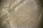
Nazca lines in the shape of a spider

In attempts to understand the how the Nazca Lines were used and what they meant for the Nazca culture several archaeological techniques can and were used on the site. For some of the more recent investigations, maps of the surrounding hills and valleys were created from the air. Doing so probably required methods of air reconnaissance such as aerial photography which later would be used with GIS to interpret the landscape. One of the early theories of the lines was studied using similar methods. Paul Kosok, a Geologist, had suggested that the geoglyphs hold astronomical significance aligning with celestial bodies, he even referred to them as “the largest astronomy book in the world.” However, Gerald Hawkins in 1968, using maps and astronomical data had disproved this idea; the figures and lines had appeared to be randomly placed with respect to sky.

Simple investigation such as surveying the landscape and understanding Nazca culture sheds light on common misconceptions. Popular media has lead most of us to believe that the geoglyphs could only be created through complex methods and that completing these works of art would not be possible without a vantage point well above the ground or alien intervention. However, it has been determined that the lines were created just by removing the top layer of soil, the soil in the Nazca desert has been oxidized and appears red, removing the top layer reveals a lighter color. Also, creation of the lines is not complex as some think, archaeologists have determined that with surveying equipment, they are easily replicable. As for the the vantage point issue, many of the images can be seen in their entirety from surrounding foothills. Just as with the burial mounds in the United States, the assumption that the people who inhabited the land were not capable of such creations or that Alien intervention was needed has roots in racism and stunts our ability to think critically about the site and culture. True archaeology helps discard these ideas and find the true story.

View of the lines up close.

References:

http://archaeologyonline.net/artifacts/nazca-lines

http://science.nationalgeographic.com/science/archaeology/nasca-lines/

http://www.skepdic.com/nazca.html

Photo1: http://en.wikipedia.org/wiki/Nazca_Lines#mediaviewer/File:Nazca-lineas-arana-c01.jpg

Photo2:http://archaeologyonline.net/artifacts/nazca-lines


For more about the site and Nazca culture:

http://whc.unesco.org/en/list/700

http://www.peru-explorer.com/nasca/nazca_culture.htm

Surveying the Titanic

Deep-sea exploration illuminates the ruins of the Titanic

On the night of April 15, 1912, the Titanic sank, killing over 1,500 people, pulling the massive ship with everything inside under the dark waters of the North Atlantic Ocean. Inside the Titanic was a bursting microcosm of life filled with a diversity of people, the remains of which still exist 2.5 miles under the surface. Being able to examine the artifacts left behind could provide an insight into life during that time as well as answer critical questions. Although the Titanic remained an important archaeological site to survey, underwater archaeology could not penetrate the depths of the ocean, – until recently.

It was coincidentally the sinking of the Titanic that allowed for its rediscovery and exploration. The use of sonar was developed partially to create safer methods of avoiding future hazards under the water. As technology developed the reach of underwater archaeology expanded. In 1985, Woods Hole Oceanographic Institution (WHOI) towed an unmanned deep-sea vehicle carrying video and sonar on miles of cable behind their boat and was able, for the first time since its ruin, to bring images of the Titanic to the public. In the following years, small manned submarines were able to circle the ruins of the Titanic while archaeologists peered out through thick Plexiglas portholes. But these small glimpses of such a massive structure were not enough to provide enough detail and recording in such short trips, and even the unmanned vehicles only viewed select areas of the ship.

Experts believe that the Titanic will not remain intact for much longer due to rust and bacteria, making it a priority. But there were many other complications besides the difficulty of being able to create a full survey. The Titanic lay in international waters making it difficult to access legally, and other companies had collected artifacts from the Titanic and were putting these up for display or auction. Archaeologists argued that they may have not been properly recorded, and that the artifacts taken were selectively – seemingly only the first class items have been picked up, creating an impression that was not wholly representative. Furthermore, the removal of items caused concern that other items may have been moved from their original locations without any record of where and how they were found. The site also contains modern trash, including many of the weights the manned submarines need to drop in order to return to the surface, and the Titanic had already taken damage from submarines that had latched onto its rails in order to get closer.

A view of the Titanic and surrounding area from the 3-D rendered map created in the 2010 expedition.

In a multiagency* expedition in 2010 the obstacles were finally jumped. With the work of two autonomous underwater vehicles (AUV) and a remotely operated vehicle (ROV), archaeologists were able to take video and make a 3-D rendering of the entire ship as well as the area around the ship in full detail, every artifact included. The complete rendering was a revolutionary step for underwater archaeology, and allowed archaeologists to finally ask and answer important questions about the Titanic.

*WHOI, the Waitt Institute, Phoenix International, NOAA, and the National Park Service

Refrences:
http://archive.archaeology.org/1205/features/titanic_shipwreck_jean_charcot_site_map.html
http://news.nationalgeographic.com/news/2010/08/100818-titanic-3-d-expedition-shipwreck-science-collapsing/

photos obtained from:
http://s.ngm.com/2012/04/titanic/img/titanic-bow-615.jpg
http://resources3.news.com.au/images/2012/03/09/1226294/528391-titanic-map.jpg

for a photo of an archaeological map made of the Titanic site:
http://www.whoi.edu/cms/images/oceanus/map_220433.jpeg

For more information:
http://eandt.theiet.org/magazine/2012/03/all-aboard-the-titanic.cfm
http://www.history.com/news/first-map-of-entire-titanic-wreck-site-sheds-new-light-on-disaster
http://waittfoundation.org/titanic
http://sanctuaries.noaa.gov/maritime/titanic/welcome.html
http://archive.archaeology.org/0101/etc/titanic1.html

Unconventional or Contextual? The Power of the Present in Understanding the Past

If I told you to get a bunch of your friends, bring them to an old building, eat bones, drink blood, and kneel at the feet of a dead nail ridden body you would be taken aback.

What if I told you that your children were encouraged to hide their identities, visit strangers, and threaten those strangers to give them cavities?

These traditions sound unreasonable, when in actuality they are going to a Catholic mass and trick-or-treating. Their true meaning is lost when taken out of context and the same applies to archaeology. Although the field has improved from a time of speculation to one of evidentiary support, the discussion of some archaeological topics is still distorted. The Mayan civilization is an intriguing area of archaeological study, but how much truth is there in this civilization’s portrayal by popular media?

It is believed, by the general public, that the Mayans spread as far as Roatán, Honduras. This Mayanization began when early archaeologists used document sources by Christopher Columbus’s son, Ferdinand, to identify private collections of Roatán artifacts as Mayan. As Ferdinand depicted these Honduras natives as possessing Mayan watercrafts, the archaeologists misinterpreted their origins. This misinterpretation is substantiated due to the tourist attraction, Maya Keys. At this site there are replicas of Copán (Mayan) artifacts, and so the visiting public assumes that Honduras was Mayan as the island representatives have taken these artifacts out of context to increase tourism.

Figure 1: Mayan city Copán’s hieroglyphic stairway replicated in non-Mayan Maya Key, Roatán, Honduras

However, archaeologist Christopher Wells has been able to use modern tools to correct this geographic misconception. Through geographic information systems (GIS) he created maps and gathered environmental data to interpret the material culture found on the island and reveal that its artifacts fit the typology, or style, of the Pech and Miskitu Indians. These populations are indigenous to mainland Honduras, dating 600 to 1,000 years ago, and are not of Mayan descent.

Mayan civilization is also associated with the end of the world and black magic to maximize public interest. Yet when compared to present cultures and analyzed with modern techniques, these practices had a more mundane purpose. Due to volcanic activity, a natural formation process, archaeologists have uncovered well preserved art illustrating the Mayan’s use of rituals to prepare for war. This art shows tzompantli, or racks of skulls, were used not for dark voodoo, but to instill fear in their enemies much like current day burglar alarms do, and teotlacualli, or a paste made of poisonous insects for spirit communication, was used in order to be able to learn from the past when developing war strategies. Additionally, through examining the trash of the Mayan elite or artifact scatters of ceramic shards, which before the use of regional survey techniques could have been overlooked or lost to excavation, archaeologists have been able to determine that Mayan sorcery was simply a way of advancing political agenda demystifying the civilization further.

Figure 2:Mayan monument of royal woman conjuring deceased warrior spirit for aid with dispute between royal houses

Ultimately, to understanding the real Mayan civilization of the past the sampling techniques and context of the present must be applied.

Read More: http://www.ancient-origins.net/news-history-archaeology/archaeologists-discover-two-long-lost-ancient-maya-cities-jungle-mexico
http://www.academia.edu/3113895/Mayanizing_Tourism_in_
Roatan_Honduras_Archaeological_Perspectives_on_Heritage_Development_and_Indigeneity

Sources: 
Figure 1: http://www.mayakeyroatan.com/content/en/activities/images/DSC_0086.jpg
Figure 2: http://www.learner.org/courses/globalart/assets/non_flash_386/work_237.jpg

Renfrew, Colin and Paul Bahn (2010) Archaeology Essentials. 2nd edition. Thames & Hudson, New York.
American Archaeology Magazine Vol. 16 No. 3 “That Old Black Magic” and “Revealing the Real Roatán”
http://www.archaeologicalconservancy.org/american-archaeology-magazine/


The Real Primitive Species?

The Great Pyramids of Egypt as well as the marble columns of Rome and Greece have never been questioned to be anything other than immaculate structures created by the people of that time period. The same credit however was not originally transferred to the works of Natives around the globe. Prior to the evolvement of archaeology and the use of scientific calculations such as carrying capacity, the assumptions made during the speculative phase were the be-all end-all. People were only categorized as savages, barbarians or civilized, whereas savages and barbarians were deemed “incapable” of any mode of civilized behavior. It was originally thought that when sophisticated features and artifacts where discovered, Europeans or other “civilized” groups already inhabited the area and left. In reality, the Native Americans were responsible for the evidence of civilization and most likely deserted the area to avoid being enslaved.

Fort St. Joseph

Figure 1: Archaeologists recovered many artifacts from the site of the Fort of St. Joseph, including an ornate crucifix of a Native woman. This crucifix exemplifies melding as Native women were clearly baptized.

Even long after the impractical assumptions of the speculative phase, everyday people as well as some archaeologists are still neglecting evidence of civilized behavior demonstrated by Native Americans. In an article discussing the rapid rise and fall of a French Fort, Native Americans were wrongly accused for the slaughter of the French inhabitants due to the ignorant assumption that Native Americans were not educated and/or sophisticated enough to have a civil and peaceful interaction. It was not until recently, after thorough analysis of artifacts and ecofacts at the site, that the relationship between the Native Americans and French was determined as a melding of civilized cultures rather than a collision. Examples of civilized melding include that the French had been hunting with Native weapons and that the two groups were married with bi-culturally raised children. As anthropologist T.R. Kidder correctly put it, “Our findings go against what has been considered the consensus on hunter-gatherer societies — that they lack the political organization necessary to complete a labor-intensive project in such a short period.”

museum

Figure 2 American Museum of Natural History where dinosaur fossils, exotic hissing cockroaches, and wondrous planetariums–right next to priceless human designed art and artifacts created by Native peoples of the Americas

Museums worldwide, such as the Museum of Natural History, wrongly place Native American art and sculptures in similar categories with dinosaur remains and tribal arts. In my opinion, this lends to the idea that Native American art is considered uncivilized and simplistic. Fortunately, other archaeologists who are still working vigorously to solve the problem, have supported my own opinion. A new exhibit called “Stereotyping Native America” features turn of the 20th Century stereotypes of Native Americans such as the mainstream American typologies that they lived in teepees, and wore feathers and animal skins. The need for these kinds of museums and exhibits indicate what little progress mainstream America has made in understanding the multifaceted history of Native Americans.

Further Reading:

Am. Archaeology. (n.d.). Retrieved September 13, 2014, from http://daphne.palomar.edu/ais130/Lectures/AmArchaeo.htm

Fort St. Joseph Archaeological Project. (n.d.). Retrieved September 13, 2014, from http://fortstjosepharchaeology.blogspot.com

References:

Stereotyping Native America. (n.d.). Retrieved September 13, 2014, from http://138.23.124.165/exhibitions/stereotyping/default.lasso

http://www.amnh.org/var/ezflow_site/storage/images/media/amnh/images/permanent-exhibitions/human-origins-and-culture-halls/hall-of-plains-indians/146538-1-eng-US/hall-of-plains-indians_dynamic_lead_hero_image.jpg

http://www.archaeologicalconservancy.org/6-u-s-forts-didnt-learn-history-class/