Road Condition Mapping for Local Municipalities

by Rebecca Odell (Geography ’20)

Village of Wappingers Falls Pavement Condition Index Map

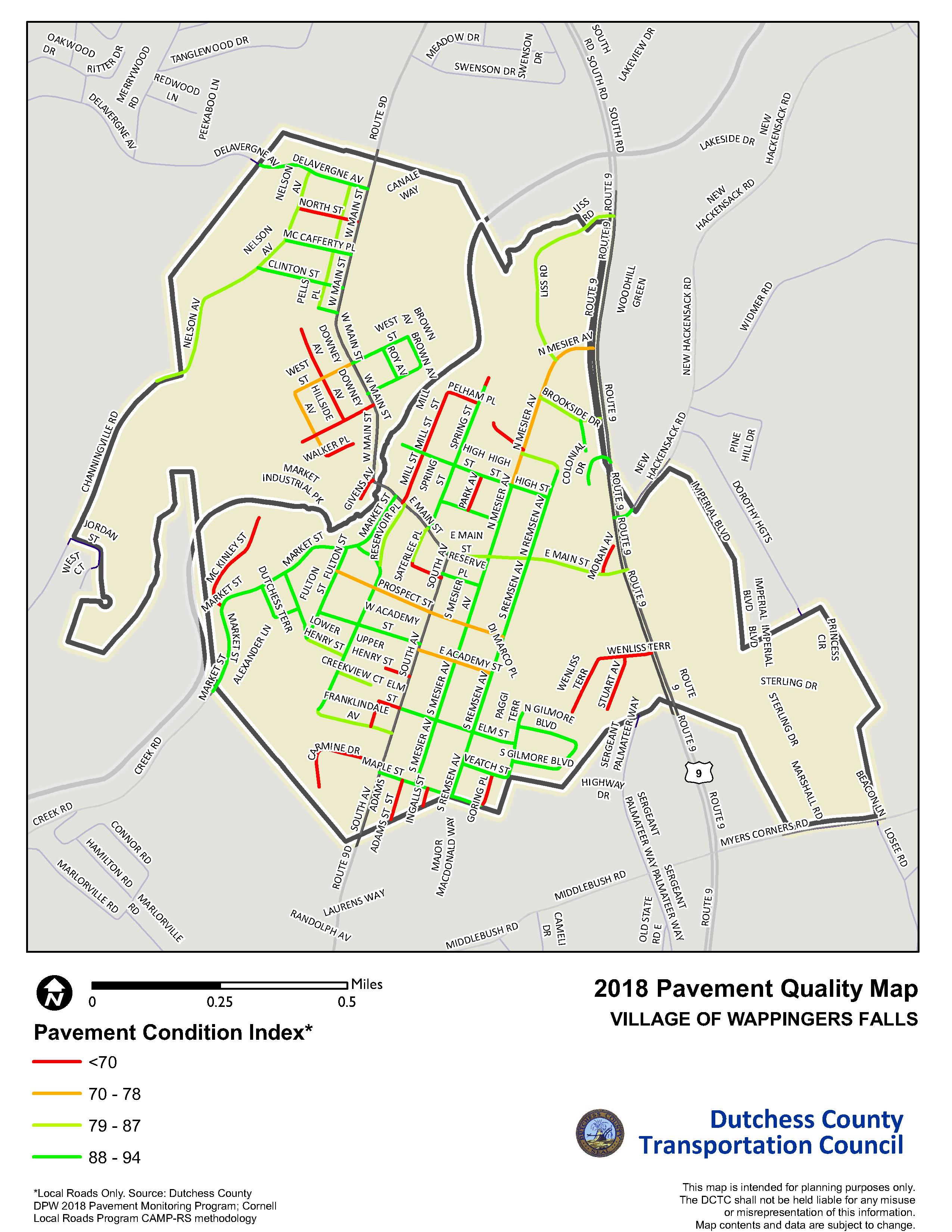
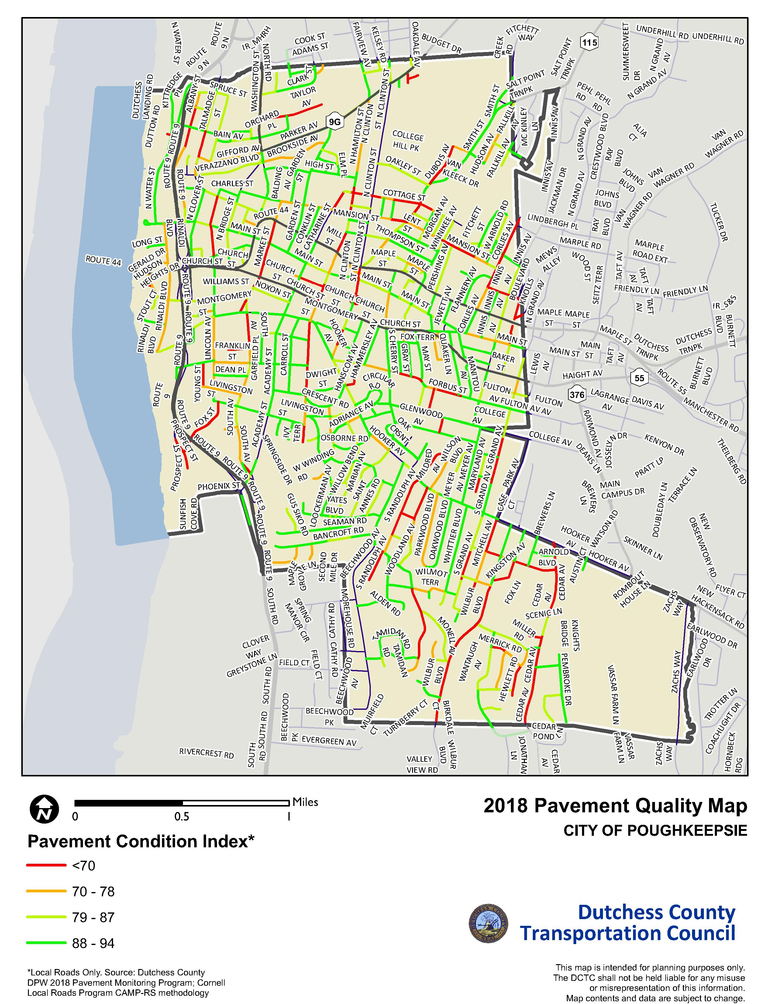
Village of Wappingers Falls Pavement Condition Index Map. Click to view full size.

As part of my internship at the Dutchess County Transportation Council (DCTC), my project was to map road quality data from past internships completed by students from Cornell University. When I first started, there was no process in place to map this data in ArcMap, and it needed to be changed in order to be compatible.

My main obstacles were that the data was not recorded in a way that was compatible with GIS, and that the roads in the Cornell data and the ArcMap data were not divided in the same way. I learned a lot about formatting data that was not made with ArcMap in mind. I also figured out how to link the divided streets in the Cornell data with sections of streets already mapped in ArcMap.

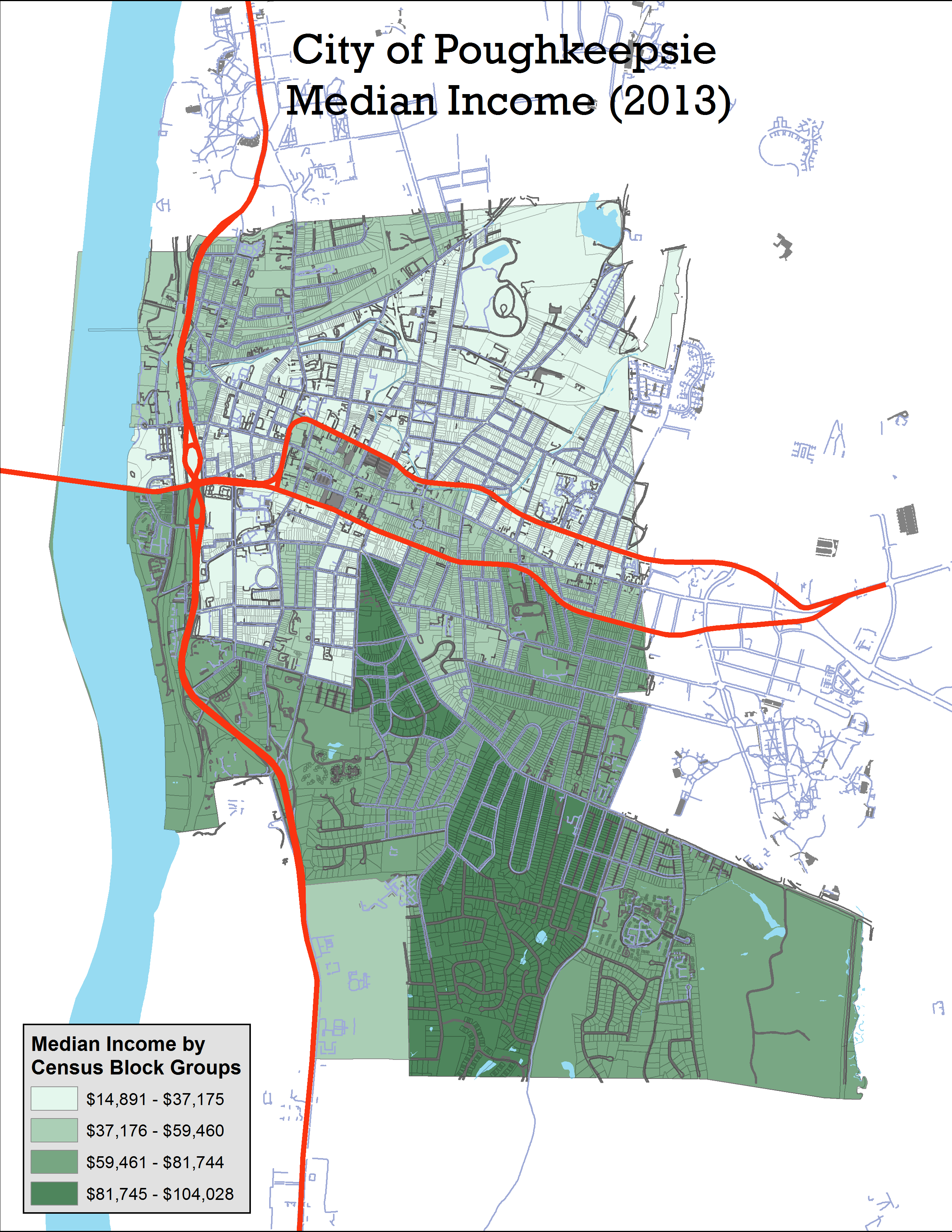
My experimentations led to a process which is now being used to finish making pavement quality maps for local governments. Maps have been completed for Beacon and Poughkeepsie, which have bigger populations and therefore more roads than most of the other municipalities. I also made maps for the Village of Fishkill, the Town of Fishkill, and Wappingers Falls. Maps allow for easy and intuitive visual comparison, which will enable local governments to make informed decisions about which road repairs to prioritize.

Posted in Cool Stuff | Comments Off on Road Condition Mapping for Local Municipalities

Office of Community Engaged Learning Placements

Adele Birkenes (Geography, 2020) is working with the Office of Community Engaged Learing (OCEL) this year to support community GIS work, and created this map of CEL placements in and around Poughkeepsie. Alternatively, you can view the larger map or see the OCEL blog (click “Opportunities”) if you prefer to scan the list of placements rather than browse them in the map. 

Continue reading

Posted in Projects | Comments Off on Office of Community Engaged Learning Placements

Estimating Pesticide Exposure and Premature Mortality by Parkinson’s Disease in Washington State

By Mariah Caballero (Biology, Geography ’19)

I spent my summer at Washington State University’s Elson S. Floyd School of Medicine in Spokane, WA. I was collaborating with researchers in the Community Health and Spatial Epidemiology (CHaSE) Lab on a project that was born of my interest in environmental health and spatial analyses. I proposed a project based on agricultural chemical exposure and premature mortality by Parkinson’s Disease in Washington State. This relationship has been well-documented1, but had not been explored in Washington State, in which Parkinson’s Disease is among the highest in the nation. Continue reading

Posted in Student Work | Comments Off on Estimating Pesticide Exposure and Premature Mortality by Parkinson’s Disease in Washington State

Cartography final projects

The Cartography class (GEOG/ESCI 220) completed another excellent set of final projects in December 2017. The aim of these projects was to convey important findings in maps and graphs, in a way that demonstrates excellent cartographic practices. 

(Click on slides to advance; open in a new tab to view larger image.) 

I have added files from 2016, as well. If you notice a map missing, I don’t have the final PDF, unfortunately!

Posted in Cool Stuff, Projects, Student Work | Comments Off on Cartography final projects

Class projects from GIS: Spatial Analysis

Students in GEOG/ESCI 224 (GIS: Spatial analysis) presented their final projects at the end of the semester. They demonstrated an excellent range of analytical approaches, combining quantitative analysis and aesthetic design for communication.

(Click on image to advance through slides. Open an image in a new tab for larger view)


Posted in Projects, Student Work | Comments Off on Class projects from GIS: Spatial Analysis

Progress on Poughkeepsie Natural Resource Inventory

A natural resources inventory (NRI) is a document that catalogues the natural and cultural resources within a given locality (e.g., municipality, watershed, or region). NRIs are used by local leaders to make informed land use decisions. An effective NRI should also illustrate where conservation efforts and preservation can be directed, and indicate where more research or focus would be helpful in the specific locality’s unique context.

The Environmental Cooperative at the Vassar Barns has been working on a Natural Resource Inventory of the City of Poughkeepsie since the spring of 2017. At that time, Rachel Marklyn ‘17 began the process of gathering existing data pertaining to the City’s natural and cultural resources.

During the summer of 2017, Elise Chessman ’18 worked on writing the water resources chapter of the City’s NRI. Water resources are a very important topic to the City of Poughkeepsie, with the Fall Kill a focal yet under-utilized part of the City and the Hudson River a notable feature of Poughkeepsie’s past and present significance. These factors made water resources a great jumping off point to begin writing the NRI. Along with a descriptive chapter on the City’s water resources, six maps were created, including: floodplains and percent developed imperviousness, watersheds, water quality, culverts and aquatic passability, and wetlands and hydric soils.

The future of the project will include writing and mapping geologic features and topography, land use patterns, and the cultural, recreational, and historic resources of the City. Hudsonia Ltd. is performing assessments on habitats and biological communities for the City as well.

As an appendix that will be included in the City of Poughkeepsie’s NRI, India Futterman ‘19 wrote an Ash Tree Management Plan, focused on the Emerald Ash Borer, which you can read more about here.

This Project has been funded in part by a grant from the New York State Environmental Protection Fund through the Hudson River Estuary Program of the New York State Department of Environmental Conservation.

Posted in Cool Stuff | Comments Off on Progress on Poughkeepsie Natural Resource Inventory

GIS and Sustainability Project Exchange

Want to make a difference? Help out by taking on a project, or suggest one.
If you want to do a thesis project or independent study that makes a difference, then start by finding out what is needed on campus.  It’s always nice to have an eager audience interested in your work, and your products are better when that audience holds you accountable for doing it well.  Here are a few questions and ideas as examples of projects that individuals or classes could take on.  Read the complete list on Google Docs, or add questions in the comments or contribute your own ideas.  

This list is just a start. Any idea may be useful. Any idea can have a theoretical angle that makes it suitable for a thesis topic. Ideas can also be found in other locations, such as Princeton’s sustainability ideas list.

You can add to this list (add your name if you want to help students develop it). Or you can peruse the list for projects that need doing. Questions? see Alistair Hall or Mary Ann Cunningham.

  • The EMMA network is currently is made up of 9 sites in the Hudson Valley, which are in need of site characterizations.  The sites are meant to create a north/south and urban/rural gradient. In particular help is needed to map the land cover, soils, streams, wetlands, waterbodies, and fragmentation. This information would be incredibly valuable as EMMA undergoes strategic planning and develops future directions. Any students that might be interested in working on this project should contact Keri Vancamp
  • What is the magnitude of ecosystem services of tree cover on the Vassar Campus? Use iTree programs to calculate them.
  • Mapping the UN’s Map Human Development Index (HDI) – This is a very extensive GIS data set based on the UN’s Human Development Report tabular data by country, and there are many topics that could be mapped to display newer HDI and related data. Some background on the dataset and the HDI report is available here. This data set is available on the lab computers.
  • Map the Greater Ecological Preserve and create a visitor’s natural history/birding/plant walk map.
  • Update and develop campus planting maps and data – Point locations of all campus plantings have been mapped and associated with maintenance scheduling information. The web map used to display this information could be further developed to include maintenance activity (accessed via web app and/or mobile app). The polygon areas of the plantings need to be mapped.
Posted in Cool Stuff, Projects, Student Work | Comments Off on GIS and Sustainability Project Exchange

Mapping Emerald Ash Borer in the City of Poughkeepsie

By India Futterman ’19

Emerald ash borer, an invasive species of beetle that arrived in the United States in packing material from Asia, has officially arrived in Dutchess County. During the summer of 2017, Elise Chessman ‘18 and India Futterman ‘19 set out to map the infestation among the street ash trees of the City of Poughkeepsie. Prior to their survey, it was fairly clear that EAB was present in the City, though the extent of its damage and its potential to spread were essentially unknown. 


View larger map Continue reading

Posted in Projects, Student Work | Comments Off on Mapping Emerald Ash Borer in the City of Poughkeepsie

Student maps support Poughkeepsie transit analysis and recommendations

Comparison of former city bus routes and new county bus routes in Poughkeepsie, with income distribution by Census block group. Map by Siennah Yang (Geography, ’18). Click to view larger version.

The recent consolidation of the City of Poughkeepsie Transit bus system into Dutchess County Department of Mass Transit’s bus system has been much debated among city leaders, bus system users, and other stakeholders. One of the voices that have engaged in the debate was Dr. Kafui Attoh, Assistant Professor of Urban Studies at CUNY, whose research focuses on issues of transportation equity. Working with Siennah Yang (Geography, ’18) to create maps comparing previous city routes and new county routes with information about the populations served and suggested alterations and additional routes, Dr. Attoh and Yang wrote a memo outlining their analysis of the routes with suggestions for improvements to better serve its users, and sent it to a number of city council members. 

Continue reading

Posted in Projects, Student Work | Comments Off on Student maps support Poughkeepsie transit analysis and recommendations

Poughkeepsie: A City Divided

Areas north of the east – west arterial have lower median incomes than those in the island created by the arterial and south of the arterial.

In this post on Mid-Hudson Currents, the Benjamin Center (at SUNY New Paltz) Blog, Senior Research Associate, Joshua Simons, outlines the geographic and socioeconomic divides in the City of Poughkeepsie through a series of maps. “It is striking how the physical barriers of the highways conform so closely to how the city is divided racially, ethnically, and economically,” Simons writes, referring to the divisions between communities on different sides of Route 9 and the east-west (US-44/ NY-55) arterial.  Continue reading

Posted in Cool Stuff | Comments Off on Poughkeepsie: A City Divided