By Katherine Giesa
Urban Studies ’16
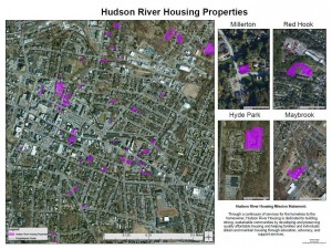
Hudson River Housing has developed many affordable properties throughout Poughkeepsie and the mid-Hudson Valley region. This map shows the location of all of their projects as of Summer 2015.
Over the summer I made a series of maps for Hudson River Housing (HRH), an organization working to encourage home ownership and provide affordable housing options for residents of the Hudson Valley. This work was completed for the Geography Field Work course (GEOG 290). Field Work courses at Vassar involve working with a non-profit organization, a government agency, or a business. Nearly every department and program at Vassar sponsors field work.
Vassar’s GIS Academic Computing Consultant, Neil Curri, helped put me in touch with Hudson River Housing and we met with them at the beginning of June to talk about what they would be most interested in seeing from a geospatial perspective. Essentially, they had a list of addresses, a list of properties they were involved with, but no visualization of their work’s location or dispersal across Poughkeepsie or the greater Hudson Valley. Continue reading

