Today’s post comes from Kelly Vinett, Vassar College class of 2020
The Loeb opened its first major exhibition of the 2019 calendar year on Friday, February 1, with Freehand: Drawings by Inez Nathaniel Walker. Exhibition curator Mary-Kay Lombino commenced the night with a lecture encompassing the artist’s unconventional entrance into the art world, including the Vassar alumna who helped her get there
Learning to See
Today’s post comes from Magdalena Ramos Mullane, class of 2022 and Art Center Student Docent. Raquel Rabinovich: The Reading Room was on view in the Thompson Memorial Library at Vassar College from October 25 through December 20, 2018, and was funded by the Virginia Herrick Deknatel Fund
How Do the Walls Around the World Function Differently?
After World War Ⅱ, the number of border walls all over the world increases significantly. Nowadays the border situation between the US and Mexico is widely discussed, and a wall is actually in people’s envision. What are some border walls in other countries like? Do they all function as the prevention of illegal migrants and refugees?
Serving similar purpose with the wall between US and Mexico, the security at Calais port between France and UK prevents illegal migrants from entering the UK. The security is equipped with detection technologies, such as heartbeat and carbon dioxide detectors, and both countries funded together for a “control and command center”. One difference between Calais port and US border wall is that Calais port prevents the migration problem “at source”, with the aid of strict systems, while the US border wall exposes migrants into the potential danger in the desert. What’s more, between UK and France governments, there is a promoted joint agreement to determine if the migrants are accepted as asylum seekers, get detained or deported.
Another example is the fences in Europe. Hungary and Slovenia are two countries with the region’s largest expanse of fences. These border fences serve to prevent illegal migrants as well but face more religious issues than the one between US and Mexico. It is revealed that people living near these barriers often find that they serve little purpose and can be psychologically damaging. For example, children in the camp in village are scared of their proximity to the fence.
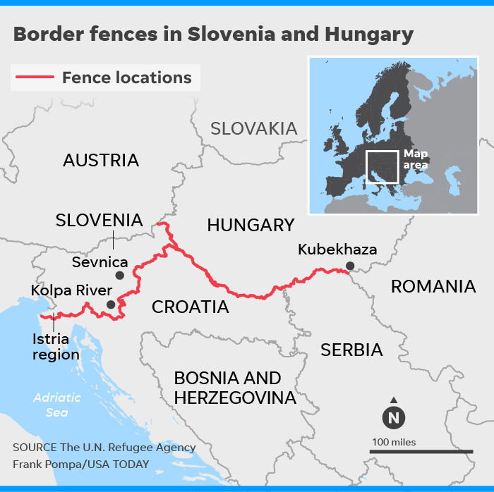
Figure 1. The border wall along Hungary and Slovenia.
We are probably familiar with US president Trump’s use of the Great Wall in China as a comparison to his plans of building the wall. However, these two walls actually serve distinct purposes. The Great Wall was built to prevent exterior military incursion instead of as a security barrier. The construction of Great Wall started in 7th century BC, went through several dynasties, and finished in Ming dynasty. The Great Wall is not impregnable in Chinese history, so perhaps the border wall between US and Mexico will not be totally impregnable as well; moreover, according to Edward Alden, trade policy expert at the Council on Foreign Relations, increased enforcement efforts along the border may explain about 35 to 40 percent of the decline in illegal immigration flow.
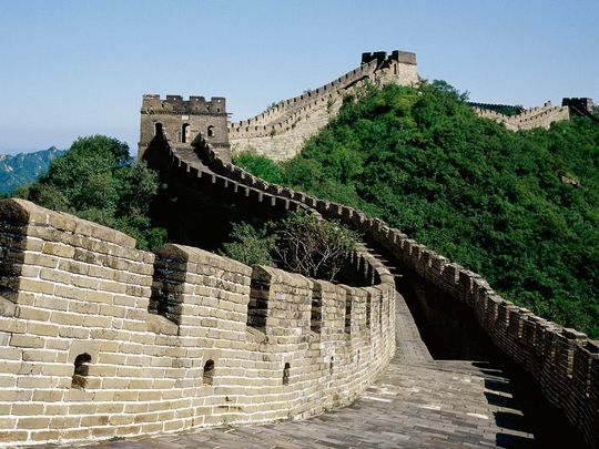
Figure 2. The Great Wall served as the prevention of military attacks.
Nowadays, the border wall that is actually similar to the Great Wall is probably the wall built by Saudi Arabia. The 600-mile-long wall in their northern frontier is built to prevent ISIS from attacking the oil-rich territory.
If the government is determined to use border wall to prevent migration, it might be better to set up an excellent system instead of exposing the migrants in danger in the desert. And even though the wall may serve well politically, we need to think about how to reduce the psychological effect it brings to people who live nearby.
References:
Hjelmgaard, Kim
2018 From 7 to 77: There’s been an explosion in building border walls since World War II. Electronic document,
https://www.usatoday.com/story/news/world/2018/05/24/border-walls-berlin-wall-donald-trump-wall/553250002/, accessed December 2, 2018
BBC News
2016 Calais migrants: How is the UK-France border policed? Electronic document,
https://www.bbc.com/news/uk-33267137, accessed December 2, 2018
Hjelmgaard, Kim
2018 Trump isn’t the only one who wants to build a wall. These European nations already did. Electronic document,
https://www.usatoday.com/story/news/world/2018/05/24/donald-trump-europe-border-walls-migrants/532572002/, accessed December 2, 2018
Michelle Ye Hee Lee
2016 Why Trump’s comparison of his wall to the Great Wall of China makes no sense. Electronic document,
https://www.washingtonpost.com/news/fact-checker/wp/2016/03/08/why-trumps-comparison-of-his-wall-to-the-great-wall-of-china-makes-no-sense/?noredirect=on&utm_term=.972ab6dde511, accessed December 2, 2018
ShantiUniverse
2015 Saudi Arabia Builds 600 Mile Wall to Keep Islamic State OUT! Electronic document,
https://www.youtube.com/watch?v=AG_m4LKOCBk, accessed December 2, 2018
Further Reading:
The (Anthropological) Truth about Walls
https://blogs.scientificamerican.com/anthropology-in-practice/the-anthropological-truth-about-walls/
The Trump Wall in Archaeological Perspective
https://howardwilliamsblog.wordpress.com/2016/11/14/the-trump-wall-in-archaeological-perspective/
Images:
Immigration Archaeology: The Trails Behind Migrants
As anthropologist Jason De León illustrates, “[a]rchaeology is about ‘trying to understand human behavior in the past through the study of what people leave behind’…[n]obody ever said the past had to be a thousand years ago” (Hartigan Shea 2018). When one hears the term ‘archaeology’, they may be tempted to think of the far past whereas it — as De León emphasizes — could refer to even one minute prior.
Today, immigration across the Mexico-United States border (into the United States) remains a prominent issue. De León has studied this area (specifically the Sonoran Desert where many migrants attempt to cross despite its gruesome conditions) in great depth. De León has been recognized by the MacArthur Foundation in 2017 for his expertise in “[c]ombining ethnographic, forensic, and archaeological evidence to bring to light the human consequences of immigration policy at the U.S.–Mexico border” (MacArthur Foundation 2017). Unsurprisingly, De León is one of the only people within the range of “archaeologists and material culture specialists” (Hamilakis 2016) to partake in this field.
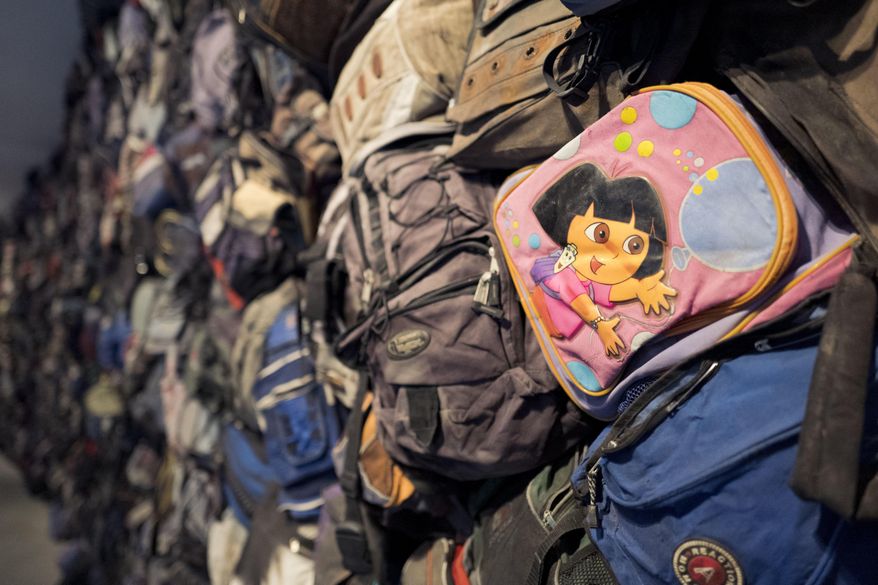
A Dora The Explorer backpack, among many others, recovered from near the Mexico-United States border and displayed in the “State of Exception” exhibit at the Sheila C. Johnson Design Center of The New School (Dobnik 2017).
On the Greek island of Lesvos, a similar situation with immigration is occurring. “[M]ore than 500,000 people crossed from Turkey, migrants and war refugees from Syria, Afghanistan, Iraq, as well as many other Asian and African countries, to [this] island with 85,000 permanent inhabitants” (Hamilakis 2016). In venturing to safer land, “[s]ome of [their] camps…can become substantial and highly organized structures despite their makeshift character, as [seen] in northern Greece” (Hamilakis 2016). These people make do with what little they have, setting up shop and moving onwards — these campsites becoming modern sites for archaeological investigation.

An aerial view of a cramped, makeshift camp in Idomeni on the Greece-Macedonia border, housing approximately 7 thousand people at the time of imaging (Telegraph Video 2016).
In regards to what immigrants jettison in regions like the Mediterranean and the Arizona desert, what is left behind “form[s] worthwhile topics for further reflection and study” (Hamilakis 2016), and a budding ‘branch’ of archaeology. By locating these abandoned objects, voices and identities are given to otherwise invisible immigrants. This growing problem of today mirrors the movement of past peoples and how they have been studied to understand why they left and where they went. However, currently — the time in which this is an issue — the world has the power to work to reach a logical solution. When looking through their belongings, one can see how these people, regarded as ‘invaders’ and ‘inconvenient’, are human. Understanding that these immigrants are giving up everything to head to safer places for acceptable livelihoods is crucial; they are leaving their past lives to stay alive.
Inevitably, there is no reason to disregard the people leaving their countries for our land of dreams, because they are just like the rest of us.
—
Additional Readings
De León, Jason
2013 Undocumented migration, use wear, and the materiality of habitual suffering in the Sonoran Desert. Journal of Material Culture 18 (4): 321-345. doi:10.1177/1359183513496489.
Papataxiarchis, Evthhymios
2016 Being ‘there’: At the front line of the ‘European refugee crisis’ — part 1. Anthropology Today 32 (2): 5-9. doi:10.1111/1467-8322.12237.
Pringle, Heather
2011 The Journey to El Norte. Archaeology, January/February. Accessed November 24, 2018. https://archive.archaeology.org/1101/features/border.html.
Works Utilized
Dobnik, Verena
2017 NYC gallery displays migrants’ backpacks, belongings. The Washington Times, February 10. Accessed November 24, 2018. https://www.washingtontimes.com/news/2017/ feb/10/ny-gallery-displays-migrants-backpacks-belongings/.
Hamilakis, Yannis
2016 Archaeologies of Forced and Undocumented Migration. Journal of Contemporary Archaeology 3 (2): 121-139. doi:10.1558/jca.32409.
Hartigan Shea, Rachel
2018 Immigration Archaeology: What’s Left at Border Crossings. National Geographic, August. Accessed November 24, 2018. https://www.nationalgeographic.com/magazine/2018/08/embark-genius-jason-immigration-archaeology/.
MacArthur Foundation
2017 Jason De León. MacArthur Foundation, October 11. Accessed November 24, 2018. https://www.macfound.org/fellows/986/.
Telegraph Video
2016 Watch: Aerial footage of crowded migrant camp on Greece-Macedonia border. Telegraph Video, March 2. Accessed November 24, 2018. https://www.telegraph.co.uk/news/worldnews/europe/macedonia/12180807/Watch-Aerial-footage-of-crowded-migrant-camp-on-Greece-Macedonia-border.html.
Images Utilized
Lennihan, Mark
2017 Migrant Belongings Art [image]. Associated Press. Accessed November 24, 2018. https://www.washingtontimes.com/multimedia/image/ap_migrants_ belongings_art_83724jpg/.
Telegraph Video
2016 Migrant Camp – Aerial [image]. Telegraph Video. Accessed November 24, 2018. https://secure.i.telegraph.co.uk/multimedia/archive/03587/migrant-camp-aeria_3587034b.jpg.
—
Memorials and the Archaeological Record
This past week in class, we talked about the way in which archaeology can help people reflect on trauma and suffering of the past. I’m interested in the way archaeological records are employed in museums and memorials to emphasize past sufferings. An example that we talked about was Holocaust museums and how the collections of the items can invoke empathy and understanding about the sheer horror and quantity of that horror that happened half a century ago. What Edward Rothstein of the New York Times calls the “archaeology of trauma” can be seen in
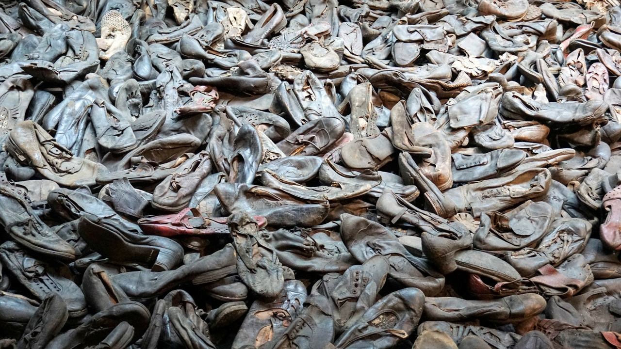
Piles of shoes from Holocaust victims at the United States Holocaust Memorial Museum.
Holocaust museums across the world (Rothstein). Special effects and simulations, and, more so on the archaeological front, collections of artifacts from the 6 million Jews who were murdered (United States Holocaust), work together to give a museum visitor an intense experience. Other memorials might list all the names of the people who lost their lives, if such records exist and are known. Growing up in Jewish day school for ten years, I’ve been to my fair share of Holocaust museums and memorials. I can say as a first hand spectator that looking at piles and piles of clothes, shoes, suitcases, jewelry pieces, or other various personal belongings from the archaeological record of the Holocaust shakes a person to the core. It gives you the physical objects to visualize the scale of the trauma and is incredibly effective at doing so.
Following the discussion of this topic in class, I became curious about how we then create this reflection on trauma if little remains from the archaeological record. What if there are no artifacts? No suitcases? No shoes? Nothing to point to the atrocity
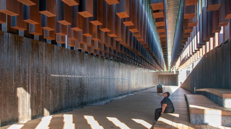
At the National Memorial for Peace and Justice. There are names and places of those murdered written on the bottoms of the hanging concrete blocks.
that happened? These questions led me to The National Memorial for Peace and Justice. This memorial, opened recently in 2018 and inspired by the Berlin Holocaust memorial, serves as a memorial for African American people who were murdered by lynching in this country throughout history (Robertson). This memorial / museum “embarked on a project to memorialize this history by visiting hundreds of lynching sites, collecting soil, and erecting public markers” (EJI). The memorial displays this collected soil, along with the names of those murdered and evocative art pieces that emphasize the historical racial injustice of this country. While we may not have the
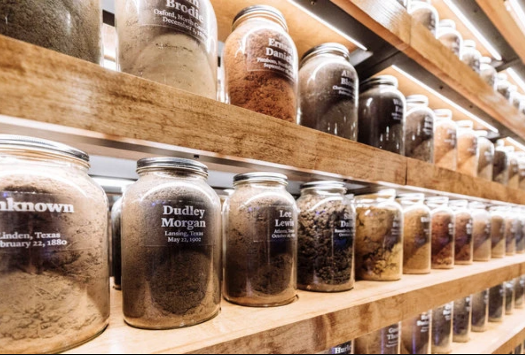
Jars of soil collected for the National Memorial for Peace and Justice
most personal belongings of every person who was a victim of racial violence, we do have access to art, to names, and to the soil: the soil that was underneath when these murders happened. They provide the context for the history that happened. We can look at that soil and feel the horror of what it witnessed. The art provides our narrative. We can look at the art and feel the pain of what happened. I’ve been brought up with the understanding that objects are what gives a historical event its weight, but perhaps we should rethink that definition. Doing so might stop the erasure of historical trauma that cannot always be articulated through objects.
Additional reading on this topic:
For the Equal Justice Initiative’s piece and video about why building this memorial was important, click HERE.
For more images and a look inside the memorial, click HERE.
Sources Cited:
2018 EJI. The National Memorial for Peace and Justice. Electronic Document, https://museumandmemorial.eji.org/memorial , accessed November 19, 2018.
Robertson, Campbell.
2018 . NYTimes. A Lynching Museum is Opening. Electronic Document, https:/www.nytimes.com/2018/04/25/us/lynching-memorial-alabama.html , accessed November 19, 2018.
Rothstein, Edward.
2012 . NYTimes. Holocaust Museums in Israel Evolve. Electronic Document, https://www.nytimes.com/2012/09/05/arts/design/israels-holocaust-museums-evolve-in-message-and-methods.html , accessed November 19, 2018.
2018 United States Holocaust Memorial Museum. Documenting Numbers of Victims of the Holocaust and Nazi Persecution. Electronic Document, https://encyclopedia.ushmm.org/content/en/article/documenting-numbers-of-victims-of-the-holocaust-and-nazi-persecution , accessed November 19, 2018.
Image sources:
Holocaust museum shoes – http://solotravelgirl.com/solitude-and-reflection-in-the-u-s-holocaust-memorial-museum/
National memorial for Peace and Justice – https://massdesigngroup.org/work/national-memorial-peace-and-justice
Jars of soil – https://www.nytimes.com/2018/04/25/us/lynching-memorial-alabama.html