 By Mariah Caballero (Biology, Geography ’19)
I spent my summer at Washington State University’s Elson S. Floyd School of Medicine in Spokane, WA. I was collaborating with researchers in the Community Health and Spatial Epidemiology (CHaSE) Lab on a project that was born of my interest in environmental health and spatial analyses. I proposed a project based on agricultural chemical exposure and premature mortality by Parkinson’s Disease in Washington State. This relationship has been well-documented1, but had not been explored in Washington State, in which Parkinson’s Disease is among the highest in the nation.
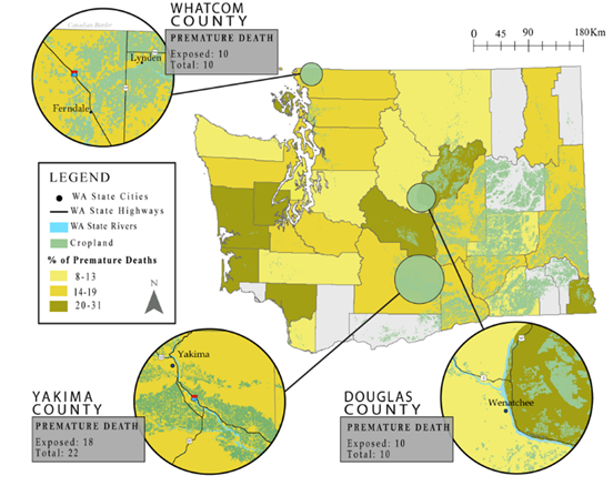
Using geocoded death data for Washington State from 2011-2015, the residential location of over 4500 deaths by Parkinson’s disease were obtained. In ArcGIS, Mariah reclassified USDA crop data from the years 2011-2015 to create four distinct layers that represented the land-use associated with pesticides that have been shown to have neurodegenerative effects (Atrazine, Diazinon, Glyphosate, Paraquat, and a summed layer of all pesticide). She buffered the location of deaths for 1000 m, as pesticide drift has been shown to drift up to one kilometer from its target application. Those within 1000m of land-use attributed to the specific pesticide application were considered exposed, and vice versa.
A bivariate logistic regression analysis was implemented, controlling for demographic characteristics. She found that individuals exposed to land-use associated with Glyphosate had 33% higher odds of dying prematurely than those who were not exposed. Exposure to cropland associated with all pesticide application or Paraquat application was not significantly associated with premature mortality, but the effect size was in the hypothesized direction. There were no significant associations between exposure to Atrazine or Diazinon.
The map above was created to show the percent of premature deaths on a county-level, with inset maps of geographic areas that presented high spatial correlation between premature mortality and proximity to Glyphosate and/or Paraquat application. When considering premature mortality on an individual level, several clusters of premature deaths were found in highly agricultural areas. A clear relationship was found in Douglas County, where rates of premature deaths attributed to PD were highest in the state (31%). A sizable clustering of premature deaths was found near the Northwestern border of the county. Within this cluster, all premature deaths that occurred in the area fell within 1000 meters of Glyphosate and/or Paraquat application. The proportion of deaths in Yakima valley was similarly indicative, with eighteen of the twenty-two premature deaths falling within 1000 meters of Glyphosate and/or Paraquat application.
These findings are currently under manuscript review for a peer-reviewed journal.
References
1. Ritz B, Costello S. Geographic model and biomarker-derived measures of pesticide exposure and Parkinson’s disease. Annals of the New York Academy of Sciences. 2006;1076:378

