By Ellie Opdahl
Research and Restoration Post Baccalaureate Fellow, VCEE Co-op

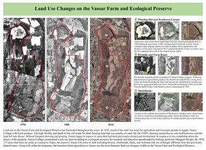
Aerial images of the Vassar Farm and Ecological Preserve (VFEP) taken in the years 1936, 1980, and 2014. The red outline denotes the preserve boundary. 1) Refers to the northwest corner of the preserve 2) refers to the drumlin 3) refers to the shrublands. (click to enlarge)
Beginning this fall, the South wing of the historic cow barns located on the Vassar Farm and Ecological Preserve (VFEP) will begin to be renovated as headquarters for a greater conservation initiative in the Hudson Valley. Organizations including the newly established Vassar Conservation and Environmental Engagement Cooperative (VCEE-COOP) as well as other like-minded organizations such as the Hudson Valley chapter of the Student Conservation Association (SCA) will be housed in the space.
As part of a series of educational displays created for the renovation of the barn, GIS aerial maps of the VFEP were compared for land use changes on the preserve from the years 1936, 1980, and 2014. A quick look at the maps alone show striking contrasts among the years with obvious differences in land use.
In 1936, the land that we now refer to as the VFEP was still a working farm supplying fresh produce to the college. The high fertility and depth of the soil made for ideal farming conditions, and much of the land was cleared for crop production and livestock pasture. By the 1950’s, farming ceased due to cost inefficiencies, and the land fell into a period of disuse. As land maintenance discontinued, forests began to regrow in areas that had been previously cleared. In response to tax complaints concerning the disuse of the property, Vassar College created a mix-use land use plan including an ecological preserve to be used for research and education spearheaded by biology professor Margaret Wright. By 1976, 275 acres had been set aside as a preserve. Today, the preserve boasts 416 acres of land including habitat types such as forests, shrublands, fields, and wetlands that are vastly different from the previously farmed areas. Along with urban development, the transition from agriculture to forest is the most dramatic land use change seen on the Vassar Farm and Ecological Preserve.
Some noticeable differences in land use occur in the northwest corner of the preserve. The settling ponds, an innovative plan to better manage Vassar’s waste disposal conducted by alumna Ellen Swallow Richards in 1895 were located in a cleared area that gradually turned into a mature forest. The vestiges of the settling ponds can still be seen today when hiking on the orange trail. Near the settling ponds is the Student Conservation Association (SCA) planting site. In 2013, over 1,000 trees were planted at the site in an effort to increase forest regeneration, carbon sequestration, and reduce edge effects in an area that had remained cleared despite the termination of agricultural practices. The site can be visited by following the light blue trail. Additional forest regrowth occurred on the drumlin, historically the site of the Vassar piggery. More recent land use changes can be seen near the shrublands on the southern portion of the preserve that are still in a transitional phase. Beavers have also recently arrived near the shrublands and constructed ponds, building dams that have greatly expanded the wetlands that are resulting in dynamic habitat and species compositional changes that are still occurring today.
