When Charlie Brown said that on Halloween, he was less than excited. But that’s because he wasn’t doing archaeology, where finding rocks, especially those that are part of foundations or walls, is awesome! Getting a rock for trick or treating is less fun but I digress.
When you think of archaeology, you probably imagine giant excavations, where people are uncovering dinosaur bones or ancient cities. When I went out to do fieldwork for the first time, that wasn’t exactly what we did nor what we were looking for. Surveying is a technique to find archaeological data, which doesn’t include any digging but thoroughly scanning an area (on foot, in our case) looking for evidence on the surface. It often comes before excavation (well, you have to find sites before you can dig, right?).
So basically, we went exploring in the middle of the woods. No trails and lots of tree roots hidden under leaves waiting to trip you up (living dangerously). As we navigated the hilly terrain (a great work-out, by the way) we were keeping our eyes out for evidence of a town that used to exist in Richardsville, near Kent, New York.
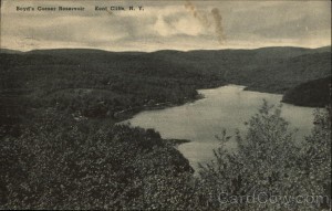
source: http://www.cardcow.com/242627/boyds-corner-reservoir-kent-cliffs-new-york/
A photograph of the Boyd’s Corner Reservoir
New York City took over the area to make and preserve reservoirs for the city in the late 19th – early 20th century, so the town was abandoned. Dr. Beisaw wants to examine how the uprooting affected the local people and culture. Conclusions drawn from the past can help determine how regulating people for environmental reasons will have an impact today and how to lessen said impact. That’s the point of archaeology, to use the past to help improve the present and future! For anyone interested in learning about the watershed conservation controversy, here is an interesting segment about it from WNYC radio.
The reality is that if you haven’t already explored the area you’re researching, there is no way of knowing if anything is there. My group’s trails didn’t seem to be yielding many results. However, when we reached the end of our assigned area, we did end up finding something! We came across a large, curved stonewall and a metal sheet (part of a roof, perhaps?) propped up on rocks on the inside of the curve. We speculated that there might have been construction in the area, especially given the concentration of large boulders and other rocks that most likely were not deposited by nature.
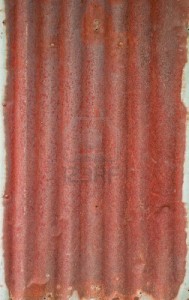
source: http://www.123rf.com/photo_14168605_background-image-of-rusty-corrugated-iron-sheets.html
This is similar to the metal sheet we found. It doesn’t look like much, right? Well, when you come across this in the middle of the woods, after hours of looking for evidence of human habitation, this is one of the coolest things ever.
Overall, fieldwork has to be approached with an open-mind, open eyes, and the energy to hike! And we didn’t just end up with a rock, we got a whole wall of rocks!
references:
Beisaw, April. “Field Survey Manual”. 2013. Web. Access October 6, 2013. http://moodle.vassar.edu/pluginfile.php/226607/mod_resource/content/1/BeisawFieldManualCatskills.pdf


Like the Ashokan reservoir, the Boyds Corner reservoir also supplies water to New York City, and its construction similarly displaced some residents in its immediate vicinity. And, just as with its neighbor to the north, the Boyds Corner reservoir is a flashpoint for watershed controversy that pits locals against the Department of Environmental Protection. The DEP page on this reservoir, interestingly, makes no mention of the people who were displaced by the reservoir, and instead focuses on its recreational opportunities. While the Boyds Corner reservoir is mainly dedicated to fishing, and the surrounding woods to hunting and hiking, there is little infrastructure (parking lots, trails, etc.) that facilitates the recreational activities possible in the area. While the three teams surveying the woods found evidence of past human settlement – the rusted metal you talk about here, as well as a large system of dry stone walls, which could have served as property boundaries, which we encountered on our hike back to the car. If our archaeological team had not come looking, how long would those structures and artifacts gone unnoticed by hunters and the few hikers brave enough to explore without a trail? What can we do to ensure that the history of the towns, which once stood here, is not forgotten? One possible option, which Dr. Beisaw discussed, would be a possible hiking trail; the route would bypass historical structures, like the stone walls, with interpretive signs to teach hikers about the communities that once dotted the hillside. What other options can you think of?