Feed on
Posts
comments

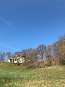
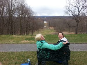
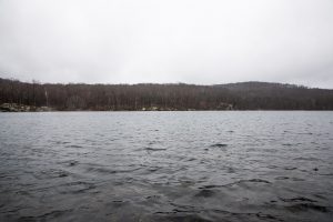
Welcome to Wilderstein historic site, located at 330 Morton Rd, Rhinebeck, NY 12572. The site was purchased in 1852 by Thomas Suckley. He was a descendant of Beekman and Livingston families whose fortunes in export trade and real estate investments allowed Suckley to make the purchase. Suckley and his wife Catherine Murray-Bowne wanted a building rich with natural features. The viewshed of the Hudson River from the property made this site perfect. Suckley named the property “Wilderstein” or wild man’s stone.

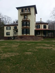
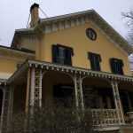
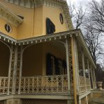
The original Italianate villa designed by John Warren Ritch was remodeled and enlarged in 1888 by Thomas’s son Robert Bowne Suckley and his wife, Elizabeth Philips Montgomery. Poughkeepsie architect Arnout Cannon was hired to transform the two-story villa into an elaborate Queen Anne style country house. The structure now soared upward with the addition of a third floor, multi-gabled attic and a dramatic five-story circular tower with a commanding view of the surrounding landscape. The fanciful, asymmetrical skyline of the house was enhanced by the addition of an imposing porte-cochere and an expansive verandah.

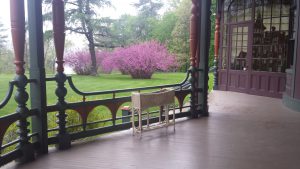
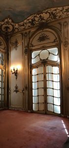
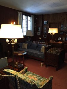
The fashionably appointed interiors were designed by the New York City decorator, Joseph Burr Tiffany. With the ground floor rooms executed in contrasting historic revival and aesthetic movement styles, the interiors at Wilderstein offer a splendid microcosm of the decorative arts during this period of American design. The self-conscious opulence of the newly remodeled Wilderstein was complimented by the Picturesque Landscape design of Calvert Vaux who laid out the grounds at Wilderstein according to the principles of American Romantic Landscape style.

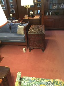
The last resident of Wilderstein was Margaret Suckley. She was known for being extremely close to Franklin Delano Roosevelt and was with him when he died, in 1945. Margaret would go on to live in Wilderstein till 1991. Other several generations, the Suckley family has amassed tons of personal items that are on display in the home.

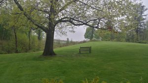
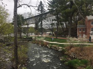
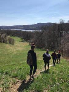
Hudson River viewshed

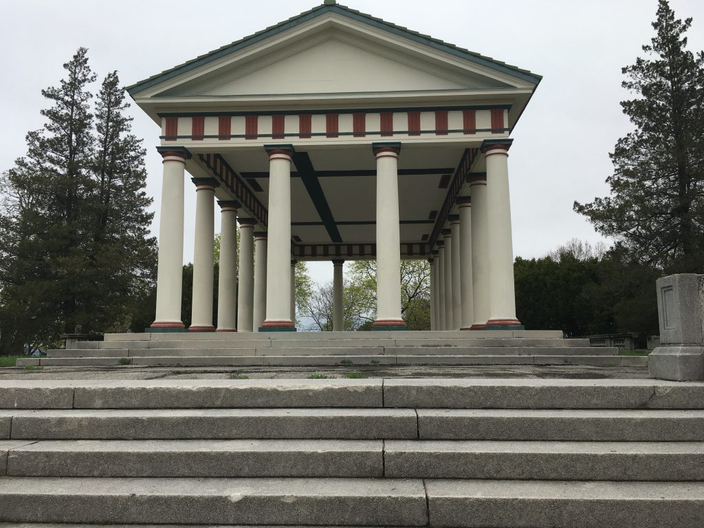
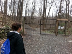
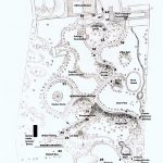
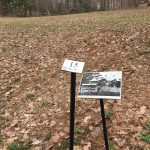
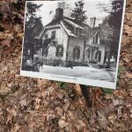
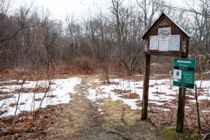
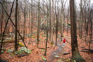
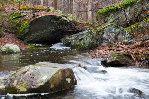
The Wilderstein Historic Site is made up of 40 acres, originally designed by landscape architect Calvert Vaux. The grounds are open year-round every day from 9 am until 4 pm. There is no charge to walk the grounds or its trails.

After stopping at Upper Landing Park we visited its larger, though less financially equipped counterpart (or should I say… counterpark?). College Hill Park proved to be a little more neglected than insinuated by Ann Perry in an interview with the Poughkeepsie Journal, who was not able to attend our meeting at the site on that particular day. However, the area still seemed to be somewhat of a popular spot for residents of Poughkeepsie. Several cars entered the land while we were there; most were heading to the golf course, but a few wandered up the road to the pavilion to relax in their cars and enjoy a couple beers on the scenic hill.

The pavilion as seen from the pavilion loop.

The pavilion itself was in fair shape, though as we drove up to it on the winding road under a cloudy sky it gave us a sensation of the “heebie jeebies”. Knowing the history of the area, from its time as the Collegiate School, then as a hotel, and finally as John Guy Vassar’s intended orphanage, it was easy to imagine how the park could have looked in the past. In the center of the pavilion, it was easy to find a plaque commemorating Guilford Dudley, who bequeathed $22,000 in his will to erect this structure.

A plaque found in the center of the pavilion.

In addition to visiting the pavilion and grounds at the top of the hill, we stopped by the rock garden farther down towards the entrance. At first it seemed like a particularly rocky area on the hill, but as we started walking among the clusters of stones and boulders we found that the rocks were placed with intention, forming a path for a stream from a dried up pool. Due to the timing of our visit, the trees and other greenery were not full of flowers and green leaves as they are meant to be, but during later spring and summer, it’s easy to imagine that this area would clearly blossom as a beautiful rock garden.

A plaque found in the garden.


Upper Landing Park is a small, manicured park located right by the historic Walkway Over the Hudson. The park was once Poughkeepsie’s northern-most commercial dock along the Hudson, hence the name Upper Landing. It’s historical significance is also believed to be where Poughkeepsie was originally founded. The City of Poughkeepsie owned the area until 2012, when it was bought by the Dyson Foundation and is now managed by New York State Parks.

The view of Upper Landing Park, the Fall Kill Creek, and the Walkway Over the Hudson

We were graciously greeted by Eric from New York State Parks and Theresa from the Dyson Foundation to give us more information about the park. The park was small and easy to explore, and was clearly built  for urban trekking; the park included nicely paved paths and picnic tables for visitors to sit at.

Paved brick roads and green spaces

Our experts emphasized the fact that the park was made for two primary reasons: one was to eliminate the possibility of a housing development on valuable waterfront property, and the other reason was to act as a corridor or connector to the Walkway Over the Hudson. The highlight of the park is an elevator that will take visitors from the park to the walkway, which was also highly advertised both in the park on on the park’s website. The Dyson Foundation’s main incentive to invest in the park was the potential it held for spurring economic growth in the area, particularly in conjunction with the Walkway.

Pathway to the highly anticipated elevator ride

The experts conveyed to us that the park was a multi-use park, with about 500,000 visitors a year. They can host events such as galas and private weddings on their patio, as well as Movie Night during the summer which draws many community members. The park is also involved in New York State’s I Love My Parks Day, an event which Eric was particularly excited for Upper Landing Park to participate in. We enjoyed the historical blurbs and buildings located throughout the park, a sculpture made of steel from the Walkway Over the Hudson, and the elevator ride up to the Walkway. It was perhaps a small glimpse into what Poughkeepsie could be in the future.

Aerial view of the park from the elevator, with Waryas park extending beyond it

After visiting Eleanor Roosevelt’s home, we went to the Vanderbilt mansion, another historical house museum in Hyde Park. However, unlike Roosevelt’s small, modest home, the Vanderbilts’ is huge, totaling 55,000 square feet. And, this was home to only two people—Frederick Vanderbilt and his wife, Louise.

Frederick Vanderbilt was the son of William Vanderbilt, an heir to a massive railroad and shipping empire. William did not leave much of this fortune to Frederick, because he highly disapproved of Frederick’s marriage. Frederick received $10 million, which was substantially less in comparison to amounts his siblings received.  However, Frederick managed to amass a fortune in his own right, while most of his siblings died bankrupt.

Frederick purchased this estate in Hyde Park in 1895, and had the mansion built between shortly after.  He and Louise designed it intricately in Italian Renaissance style, reflecting the opulence of the Gilded Age.  The gardens were also in this style, and he kept them resplendent in roses. But the story of Frederick and Louise, as told by our excellent tour guide, allowed us to understand that while they sought to live in an ornate home complete with every type of modern convenience available at the time (such as electricity!), they still sought to live life in peace, a life outside of that of other wealthy families. Thus, rather than hosting events exclusively for people in their wealthy circles, they would instead host events for their servants and servants’ children.  The guide mentioned how they often hosted events such as ice-cream socials, where all of them would enjoy strawberry ice-cream outside on the lawn. (Although, one of our readings did mention how they did not permit cyclists onto their property, so perhaps the tour guide was painting them in a better light than what they were actually like?)

Since they had no children, they left their estate to Louise’s niece, Margaret Van Alen, after Frederick’s death in 1938. Margaret attempted to sell it, for even as little as a few hundred thousand dollars, but there were no buyers. Franklin D. Roosevelt convinced her to donate it to the National Park Service, and this is the reason we are able to visit it today!

We, as a class, really enjoyed walking around the property. We especially liked walking down the massive, grassy hill by the front of the house, which led us toward trails by the Hudson River. We also explored the gardens, although not yet in bloom, and were able to appreciate the landscaping. The tour within the mansion was also very enjoyable, however, due to construction, some parts were closed.  The tour guide revealed to us at the tour’s end that the mansion has ghost stories of its own, experiences by staff members such as himself. These include hearing unidentifiable voices and footsteps!

The beautiful view from the mansion. As you can see, our class was excited to go down the hill to explore the trails and get a closer look at the Hudson River.


The view of the mansion from the bottom of the hill.

Evidence of the intricate moldings and designs within the interior of the mansion.

Exploring Val-Kill

The Eleanor Roosevelt national historic site, otherwise known as Val-kill, offers an informative look into the estate of an important character in American History accompanied by beautiful grounds complete with miles of hiking trails. When visitors arrive at Val-Kill, they are greeted by a bucolic landscape with multiple historic structures, including a building known as Stone Cottage, and Val-Kill cottage, which was once the home of Val-Kill industries before being converted to Eleanor Roosevelt’s primary residence.

Stone Cottage
(https://www.tripadvisor.com)

The official tour starts with a short biographical film, followed by a brief explanation of the site by a park ranger, and finally a guided tour of Val-Kill Cottage.

Val-Kill Cottage
(http://www.keyword-suggestions.com)

Although only about half of the items in the cottage are original pieces, the interior of the house has been decorated to look the same way it would have looked in 1962, when Eleanor Roosevelt died. This site tells the story of a visionary woman who staunchly stood for what she thought was right.

At this site, Eleanor Roosevelt is described as a powerful advocate for civil and human rights who used her charisma and drive to continue making an impact long after the death of her husband, and on until to the last year of her life. There is also an emphasis on the history of Val-Kill as a historical site itself. The interpretation at the site emphasizes the importance of Val-Kill as the only national historic site dedicated to a first lady. The story told at Val-Kill seeks to challenge the underrepresentation of women in national historic sites. The Interpretation at the site emphasizes Eleanor Roosevelt’s reputation as a powerful individual who made a great impact on the world, despite the fact that she is sometimes unfairly overshadowed by the accomplishments of her husband in popular historical discourse.

Just off of Route 9, you’ll find Locust Grove, a National Historic Landmark that includes a mansion that was once inhabited by Samuel Morse, the inventor of the telegraph and Morse code, along with expansive grounds with flowers tended to by volunteers, great views of the Hudson river, several pet cemeteries, and driving roads that were converted into hiking trails for public use. Thanks to Ken Snodgrass, Executive Director of Locust Grove, we came away with more knowledge about the estate, its history, and inhabitants.

Locust Grove is an independent, non-profit that is self-supporting. In 1847, Samuel Morse bought the land and hired Alexander Jackson Davis, famous nineteenth century architect, to design and draft the house. After Morse’s death in 1872, the house was given up and was later rented by the Young family in the 1890’s. One of the Young’s daughters, Annette, would live at Locust Grove for the rest of her life, ending in 1975 with her passing. Annette Young bought land surrounding the estate in order to protect it from encroaching residential and commercial development in a time when more of the neighboring estates were being demolished. Annette Young was an intriguing character who was essential in establishing Locust Grove as it exists today. Thanks to the robust Locust Grove collection, the estate is restored based on the photographs the families have kept and the house still has the original furniture.

In addition to the house, there are expansive grounds that serve as a park. Because the house is built on a cliff near the Hudson River, there are great views which newlyweds take advantage of for photographs. There are several trails that range in difficulty, some of which go right up to the Hudson. Go to Locust Grove to learn about the vibrant history of the mansion’s inhabitants and soak up the views!


After a trip to the beautiful Locust Grove, we drove down Route 9 to Academy
Street and stopped at the Springside historic site. From 1850-1852 Matthew Vassar worked with Andrew Downing to create his rural estate that is today known as Springside.  As we pulled up to Springside, the first thing we saw was a statue of Matthew Vassar similar to the one on Vassar’s campus.

None of us knew what to expect as Professor Beisaw told us that she couldn’t even figure out Springside and that it’s like walking into a maze! She was not wrong! We separated into two groups with the intention of meeting at the cottage foundation. We were instantly confused. Although the map had numbers where different sites were supposed to be, the signs on the property did not correspond to the site, and the sites did not correspond to the map.

Above you can see the map we were given, a few signs with numbers and pictures, but no historical sites, and definitely no cottage ruins! Finally, after walking a bit further we stumbled upon what we think were the ruins!

It was pretty cool to finally find something in the maze that is Springside! Despite all the chaos that Springside may be, I enjoyed exploring the area and learning more about Matthew Vassar’s past. Further, even though Joan provided us with a ton of expert information about the site; as a tourist, it was weird to have no idea where we were going or what we were seeing at any given time.

I think Springside is a pretty good example of a place that could use a lot of volunteers to bring it back to life and create a pretty awesome historical (and environmental) site!!


I am also going to briefly blog about our other adventures after Springside. We first stopped by Maple Grove, a mansion from the 1950s and  then the old cider mill right near the THs (where our van got stuck!).


Just over 17 miles south-east of the city of Poughkeepsie, NY and 26 miles north-east of Newburgh, NY, the national and world-renowned foot-path, the Appalachian Trail, intercepts the Beekman Uplands Loop Trail and the Nuclear Lake Loop Trail. In a motif of blue and white blazes, the blue-blazed Beekman Uplands Loop Trial takes you from the Nuclear Lake Municipal Parking Area right off of Route 55 into the woods, past a wooden kiosk with a local snapshot of the Appalachian Trail, a warning about ticks, and Leave No Trace Guidelines, and under power lines before merging with the white-blazed Appalachian Trail at a “T”.

Kiosk at the beginning of the Beekman Uplands Loop Trail

Following the Appalachian Trail to the left, you descend and ascend small hills, hop-scotch across a flooded forest flatland, cross bubbling creeks (atop bridges or navigating straight through), and scramble around large moss-covered boulders. In addition to absorbing the picturesque woodland, make sure to take care with your steps as the trail has many rocks (both sharp and loose), tree roots, and wet spots -especially on a rainy day.

The Appalachian Trail in Pawling, NY

After crossing two bridges, the trail will split into the yellow-blazed Nuclear Lake Loop Trail up and to the right, and the Appalachian trail continuing to the left. These two trails circle around Nuclear Lake, which will come to view a couple more minutes down the Appalachian Trail.

Creek on the Appalachian Trail in Pawling, NY

Nuclear Lake is a stunningly serene small lake with a rocky forest as its frame. The Lake got its name from a nuclear fuel testing plant run by the United Nuclear Corporation that used to have a facility on the south-west shore of the lake. The Appalachian Trail passes right through the grass-covered spots where the facilities used to stand. In 1972, there was a plutonium spill, however, the area has been declared safe for the past 40 years by the Federal Nuclear Regulatory Commission.

Nuclear Lake, Pawling, NY

Among local controversy, this area became part of the Appalachian Trail in 1979, and since has been repurposed by local and through-hikers alike as a place repurposed for outdoor recreational use.

Despite its history, this area and lake remains a peaceful and enjoyable place to hike, boulder, picnic, or simply go for a nice stroll through the arcane woods and around the placid lake, and it is, moreover, quiet, especially on rainy days.


For their final project, the students created this brochure of their top Hudson Valley sites that show the connection between historic preservation and environmental protection. Download it a take a road trip. enst-291-brochurefinal

In the middle of Beacon, NY’s Main Street, lies the Beacon Institute for Rivers and Estuaries. Their mission? To: “leverag[e] science and technology to understand and protect rivers, estuaries and other important freshwater resources”. In 2003 Beacon was announced as the future home for a research and education institute on the Hudson River envisioned by the former Governor George Pataki. Eight years later the Institute officially partnered with Clarkson Institute and is now the home of educational resources and community events.

14725217_10209286021322237_387542204_o

           Institute Storefront on Main Street

The Institute has an interactive “Sensor Place” where visitors may interact with a 3D visual watershed, among other activities. It also serves as a beautiful gallery, complete with exposed brick walls, which is currently exhibiting: “Along the Mt. Beacon Incline Railway: Past, Present & Future”. One of the institutes latest event series is “Science Cafè” where professors, scientists, and community members can all interact.

14741180_10209286023042280_2139325047_n

                     Interactive Watershed

In our visit we were able to attend a special presentation about the Institute’s history and Denning’s Point. We learned about the struggles to make Dennings Point the place and resource it is today, to visions of the future. These goals ranged from new building proposals and modifications to visions of the Institute being the national and international hub of river research. I would recommend that anyone already interested in environmental studies or who is curious to learn about something new (for free) stop by the Beacon Institute for Rivers and Estuaries on the way to Dennings Point or as part of a Beacon day trip.

14699498_10209286044362813_588436859_o

           Gallery with Current Exhibition

« Newer Posts - Older Posts »