Tepe Hissar
May 9, 2017
Alternate spellings: Tappa Hesār, Tapeh Hesar, Tappeh Hesar, Tappe Hesar
The site of Tepe Hissar was an important location in Central Asia during the Late Neolithic time period and leading up to the Iron Age. It is located in northeastern Iran, just south of the city of Damghan. It experienced three major periods of inhabitation, and is known for its burnished grey pottery and lapis lazuli bead-working.
The first excavation of Tepe Hissar was led by Erich F. Schmidt in 1931-1932 on behalf of University of Pennsylvania Museum. There were two seasons of excavation, the first from July to mid-November in 1931 and the second from May through November in 1932. While Schmidt’s main objective in these excavations was to uncover more information about Tepe Hissar, he was also preoccupied with having to provide artifacts for the sponsoring museums in Pennsylvania and Tehran, which would be split 50/50 as according to the revised Iranian Antiquities Law. He often accredited signs of cultural change to the invasion of foreign ethnic groups, as was typical of anthropologists during this time period. There was another excavation organized in 1976 by the University of Pennsylvania Museum, Turin University, and the Iran Center for Archaeological Research (Gürsan-Salzmann, 2016).
Schmidt divided the stratigraphy of the site into three parts: Hissar I, Hissar II, and Hissar III. The starting point of Hissar I is slightly unclear, but is recognized as having occurred after 5,000 BCE. The second period, Hissar II, is dated from the 4th millennium to the beginning of the 3rd millennium BCE. It is believed that Hissar III ended before the Iron Age, and most sources place the end of occupation at Tepe Hissar at sometime in the first half of the second millennium BCE (Voigt and Dyson, 1992). This is evidenced by the absence of iron in Hissar III (Gürsan-Salzmann, 2016). While Schmidt relied heavily on ceramic findings in dating the various periods of human occupation at Tepe Hissar, more modern techniques, such as radiocarbon dating, have provided more accurate boundaries between the periods. For example, radiocarbon samples have provided a range of between 2800 to 2400 BCE for the Hissar III time period (Bovington, 1974). The dates of these time periods have also been largely inferred through looking at other sites in the area, which has resulted in some confusion but has also been fairly effective. For example, many of the metal and stone artifacts found resemble those of the Early Dynastic period in Mesopotamia, while others appear to belong more to the Akkadian or Ur III periods. This means that the objects date between 2500 BCE to 2100 BCE (Gordon, 1951).
Small amounts of calcite and steatite found with artifacts signifying various stages of bead-making. Additionally, there were bits of lapis and flint blades and drills found throughout the site, indicating that the manipulation of precious stones was a viable industry. An abundance of small clay and alabaster animals was also found, which Schmidt attributed to both spiritual and utilitarian uses. Clay “stamp seals” with geometric designs were also uncovered, but there is a lack of evidence of imprints of the stamps, leading anthropologists to believe that they could be small ornaments or buttons instead. The lack of evidence could also be explained by how hastily the excavators were working. However, one “stamp seal” of interest depicted two human figures, an ibex, and snakes. This incorporation of human figures into geometric and animal designs was very unusual for the Hissar I time period (Gürsan-Salzmann, 2016).
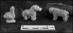
Figure 1: Three alabaster animal figures found in grave “Warrior 2″(Penn Museum, object nos. 33-15-526, 33-15-525, 33-15-524) (Photo by Jason Francisco)
The burials at Tepe Hissar were mostly found on the Main Mound and North Flat areas. Three main types of burials were identified. Most of the bodies were buried in the “pit” style, or they were wrapped in wool clothes and interred in a pit. “Cist graves” were burials within enclosures, and the objects buried with the dead are often indicative of more wealth. There were also “communal chamber burials,” ranging from two to 28 individuals. Both the “cist graves” and the “communal chamber burials” are much more uncommon than the “pit” graves. Schmidt also identified four especially wealthy graves that were discovered, which he labeled “warrior 1,” “dancer,” “little girl,” and “priest.” These individuals were buried with metal weapons, agricultural tools, and domestic utensils, including stone and copper seals, a “fan”/mirror, small clay animal sculptures, and copper, silver, and alabaster female figurines (Gürsan-Salzmann, 2016).

Figure 2: GIS map of Tepe Hissar, showing the burials concentrated in the Main Mound and North Flat areas (Gürsan-Salzmann, 2016; Kılınç Ünlü and Torres, 2010)
The people who occupied Tepe Hissar are often referred to as belonging to the Hissar, Gurgan, or Eastern Grey Ware culture. They are believed to have assisted communication and contact throughout Iran and Mesopotamia, especially towards the end of the Bronze Age (Bovington, 1974). According to The Great Soviet Encyclopedia, the Hissar culture “represents a culture, archaic in appearance, of tribes of the foothills and mountain valleys that evidently developed at the same time as the more developed, settled farming cultures in other parts of Middle Asia.” This definition reveals ideological biases related to the supposed “underdeveloped” nature of Central Asian cultures in comparison to more northern settlements. In looking at archaeological evidence, the economy of Tepe Hissar was based on agriculture. Plant remains indicate “an agricultural system based on cereals [glume and free-threshing wheats, naked and hulled barley] and the utilization of local fruit [olive, grapevine] plant resources” (Costantini and Dyson, p. 66). Some of the clay figures were cattle and sheep, indicating herding activities (Mashkour, 1996).
The site of Tepe Hissar is clearly visible on Google Earth. The coordinates are 36°09’16.13″ N 54°22’59.30″E and the elevation is approximately 3,679 feet. The site is cut in half by what seems to be a paved road, and half of the site is enclosed within another curving road.
Works Cited
Bovington, C. H., Jr., R. H., Mahdavi, A., & Masoumi, R. (1974). The Radiocarbon Evidence for the Terminal Date of the Hissar IIIC Culture. Iran, 12, 195. doi:10.2307/4300513
Costantini and Robert H. Dyson, Jr., “The Ancient Agriculture of the Damghan Plain: The Archaeological Evidence from Tepe Hissar,” in Naomi F. Miller, ed., Economy and Settlement in the Near East: Analyses of Ancient Sites and Materials, MASCA, Research Papers in Science and Archaeology 7, Suppl., Philadelphia, 1990, pp. 46-68.
Gordon, D. H. (1951). The Chronology of the Third Cultural Period at Tepe Hissar. Iraq, 13(1), 40. doi:10.2307/4199538
Gürsan-Salzmann, A. (2016). The new chronology of the Bronze Age settlement of Tepe Hissar, Iran. Philadelphia: University of Pennsylvania Museum of Archaeology and Anthropology.
M.M. Voigt and R.H. Dyson, Jr., “The Damghan/Khorasan Sequence,” in R.W. Ehrich, ed., Chronologies in Old World Archaeology, 2 vols., Chicago, 1992, I, pp. 169–74; II, pp. 127–28, 135-36.
Okladnikov, A. P. “Issledovaniia pamiatnikov kamennogo veka Tadzhikistana.” In Tr. Tadzhikskoi arkheologicheskoi ekspeditsii. vol. 3. Moscow-Leningrad, 1958.
Yaghmay Mashkour “faunal remains from Teppeh Hissar (Iran),” in Proceedings of XIII International Congress of Prehistoric and Protohistoric Sciences, Forli, Italia,September 1996 I, (3), Forli, 1998, pp. 543-51.