Feed on
Posts
comments

What is that Orange Ooze?

Picture 1

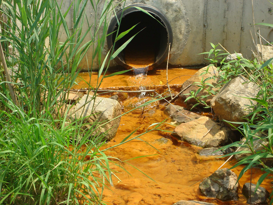
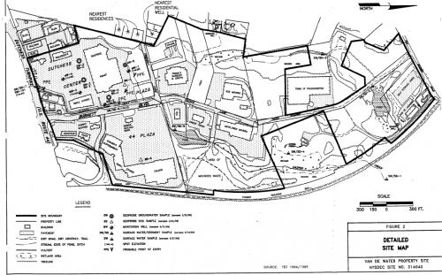
Orange ooze at the mouth of a culvert that channels water through the old Burnett Boulevard landfill underneath the Route 44 and Dutchess Center Plazas.

Background information:

Our interview with Alison Keimowitz, a Chemistry Professor at Vassar College, about the orange ooze actually started with her asking us a question: “What is in a landfill?”

Nadine and I started listing off things like pesticides, chemicals, cans, shopping carts, (pretty much anything disgusting that we could think of).  Of course, all of those things are in a landfill, but Alison wanted us to think about the big picture.  “The thing that’s special about a landfill,” she told us, “is that it has really high organic matter content…it has things that were once living, things that are mostly made out of carbon: paper, food waste, wood, and plant materials like yard clippings.”

And what happens to all of this organic matter in a landfill?  Well, just as bacteria decompose it on the surface to get energy (think about a compost pile or an animal rotting in the woods), bacteria also decompose these things underground.  The major difference, though, is that when bacteria decompose the food, newspaper, and so on underground in a landfill, they quickly run out of oxygen.

According to Alison: “Every organism that consumes organic matter needs two things: it needs the nutrients that actually physically go into the organism’s body; and it needs things so that it can get energy from chemical reactions.  This is true with people too.  People take in physical matter to make their bodies, in the form of food; and we take in oxygen.  And the reaction—there are a lot of complicated steps, but you can think about it as one reaction—with food and oxygen gives your body energy (this is cellular respiration).  Bacteria do the exact same thing.  Except unlike people, they are much more flexible… They don’t say, ‘oh well there’s no oxygen so I can’t do anything else.’”

Even without oxygen, bacteria can still live by using inorganic molecules (nitrate, nitrite, manganese, iron and sulfur) to get energy from all the yummy organic matter surrounding them in a landfill.

What does all of this have to do with orange ooze?

In the Route 44 Plaza landfill, the bacteria are using iron (rather than oxygen) to get energy.  Basically, they are converting the iron that naturally occurs in dirt—that is, iron (III)…iron with a positive 3 charge—into iron (II).  Iron (II) is a little more soluble than iron (III) in water, so it dissolves into the Casperkill as it flows underground.  When the water comes out of the culvert it is exposed to oxygen again. As soon as iron (II) is exposed to oxygen, it turns back into iron (III).  Iron (III), again, is not very soluble, so it precipitates out of the water.  The orange ooze is orange because it is really just rust dropping out of the water.  According to Alison: “Rust… that’s what the orange ooze is.  It’s basically particles of iron (III) oxides—it’s iron (III) bound to oxygen, mixed with all of the bacteria that are also getting energy by facilitating that reaction.”

What are the effects of this … is it dangerous?

One thing to worry about with iron (III) oxides is that they are really good at absorbing any other metal that comes their way.  When there are harmful things like heavy metals or arsenic in the water, it is possible for them to be captured by the iron (III) ooze.  That said, researchers from the Casperkill Assessment Project have done many tests on this ooze, and they haven’t found anything. Alison told us that, in all practicality, it’s quite unusual to see traces of other metals in this kind of ooze.  “The iron oxides themselves don’t present any hazards; they’re fine.  They’re unsightly, but they aren’t dangerous.”

Unfortunately, the unsightly iron oxide is actually one of the less disgusting things that results from bacteria breaking down food to get energy in a landfill.  In anoxic conditions bacteria also may convert sulfate into sulfide, which has a putrid rotten eggs smell; and organic matter into methane, which can build up and explode if it isn’t released in pipes.

Picture 4

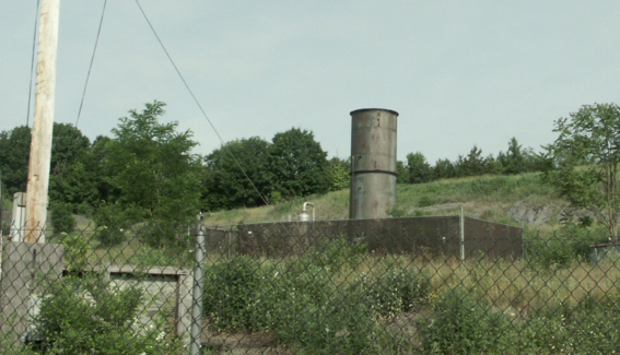
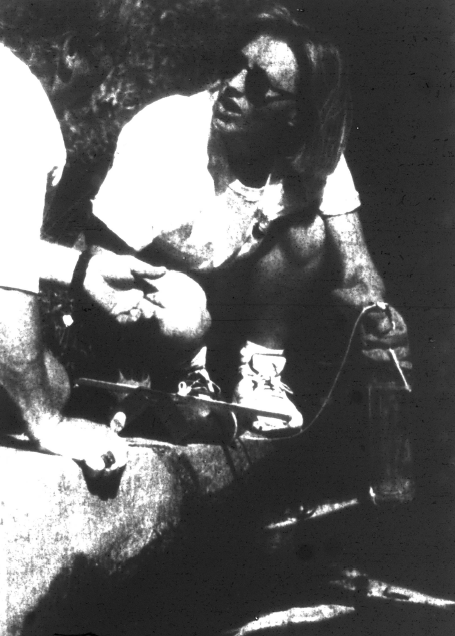
A pipe to release methane at the FICA landfill off of Van Wagner Rd.

Just for kicks, at the end of our interview I asked Alison how long these conditions would persist in the Casperkill:  “Um…eventually they’ll go away.  But we’re talking more like geologic time-scales. 10,000, maybe 20,000, years and they should be gone…maybe 30.”

Alison went on to tell us that the best way to get rid of these conditions is to try to eliminate the amount of organic waste that goes into landfills in the first place.  “What composting does is it takes all of this organic material and doesn’t put it in a landfill.  It puts it in open piles where it stays mixed with oxygen and its break-down happens much faster and in a way that doesn’t generate all of this stuff, much of which is kind of nasty.” In addition to just reducing landfill volume, you can also get free compost at the end!

Special thanks to Alison Keimowitz

Photo credits:

The Casperkill Assessment Document: Vassar College Environmental Research Institute, 2009. Health of the Casperkill, Dutchess County, New York.

“FICA landfill,” Nadine Souto, 2010
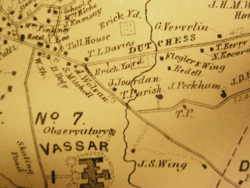
KMart parking lot

In 1940 John Van De Water leased the land that was once occupied by the Poughkeepsie Brick Corporation to the Town of Poughkeepsie (see The Rise and Fall of “Brickyard Hill”).  At that time the 120-acre property was really just an enormous hole in the ground, left from a century and a half of clay mining.  The Town proceeded to turn the site into a municipal landfill, which operated from 1948 until 1971.  The landfill greatly impacted the surrounding area and  several community members have vivid memories of the terrible smells and sights that characterized the site.  For example, Ed Lynch, who went to Arlington High School (Arlington Middle School at 601 Dutchess Turnpike previously served as the High School), remarked that he could:

Look out the window (of the school) and see the smoke…Every once in a while the fires would get out of hand and the fire department would have to come and put them out.

Once the landfill closed, development began almost immediately on two shopping plazas—the Route 44 Plaza and the Dutchess Center Plaza.  Some of the methods employed during the repaving process were questionable and unchecked by EPA regulations, which has resulted in structural and ecological problems that persist today.  These include potential leaking of methane gas, strong odors, and leaching of organic compounds into the surface and ground water of the Casperkill as well as the soil and sediment of the watershed.  Although the clay in the site provides a barrier that prevents the majority of the leachate in the landfill from migrating to the creek now, the damage has already been done.  Additionally, the shopping plazas have greatly increased amount of trash, engine fluids, and road salt draining directly into the stream.

In his article Our Lovely Casperkill, Dr. A. Scott Warthin, Jr. identifies this Burnett Boulevard Extension site (and especially its transition from a brickyard to a landfill) as the one that has largely determined the current state of the entire Casperkill:

But that hole full of water? What a marvelous place to dump garbage! So a citizen with foresight bought the worthless hole and leased it to the Town of Poughkeepsie for a dump, and the waters that flowed from the swamp down the Casperkill became rich with the organic material of the decaying garbage and charged with iron from the rusting cans. The decay process used up the oxygen normally dissolved in the water; many kinds of life that had swarmed in the stream were drowned in the waters that once nourished them. Some life, however, survived and found that the waters, though fetid, were richer than ever with the decaying organic matter; these things flourished. So the Elodea and waterlilies that once grew in Sunset Lake on Vassar College campus, were replaced by ugly mats of algae. The coliform count of the water grew so high that the Vassar girls had to give up the kayaks in which they once sported.  And for years, when the Town burned its dump thrice weekly, a north wind brought a snow of burnt paper ashes on the water… Will the Casperkill ever return to its early state? No, my friend, the marsh wren can never replace the supermarket, so let us have a care for what is left to us before it is too late.

Picture 5

Historical Landfill Areas (1940s-1970s)

Picture 4

Site in 1995.  K-Mart is in the upper left corner.

Information from:

Robins, Lucy, 2006. A Look into Past: A Land Use History of the Route 44 Plaza and the Casperkill Watershed, Vassar College.

Panoramic view of Vassar Lake from 1912, with Raymond Avenue on the right

On September 5, 1933, a Poughkeepsie Eagle News article came out under the headline “Dam At Vassar Lake Goes Out.” Heavy rains had put considerable strain on the rotting, wooden structure, causing the gate to give way and the lake to drain dry. Fortunately, the water took its natural course and no damage was done. However, the incident raised concerns about the health of the lake and sparked a debate about whether it should continue to exist.  Lack of upkeep seems to have been the main culprit, as explained in the article, which described the architecture of the lake as follows:

“The end of Vassar Lake, which is near Raymond Avenue, is closed by a highway. A culvert runs under the highway and on the opposite side of the road from the lake it is closed by a gate which originally could be raised to drain the lake. The lake has not been drained in 30 to 40 years, however, and the mechanism of the gate has long become impossible to operate.”

A later article, titled “Emptied Vassar Lake Recalls an Earlier and Quieter College,” reflected on the lake’s past as conversations over its future took place at the college.  The discovery of a plume 15 by 18 inches in the aftermath of the dam break had provided interesting clues about the lake’s history. The plume, it appears, had been constructed to insure year-round water supply for the former grist mill, which, dating back to the 18th century, was the reason the lake was known as Mill Cove Lake in the early years of the college. In 1933, the mill’s foundations remained “just behind Raymond Avenue, right across from the stream,” and the old millstone decorated the front of Rockefeller Hall. While the foundations are probably impossible to locate now, the millstone continues to stand in front of  ‘Rocky.’

IMG_0611
The millstone in front of Rockefeller Hall at Vassar. The engraved writing partly reads “from M. Vassar’s mill at Mill Cove…”

Vassar Lake, the article reported, is man-made, though no record of its origin exists. It is fed by the Fonteynkill, once a pure, healthy stream, which, already in 1933, had been “piped through the city, sent through dumps and swamps and turned into a stream of dirty, foul water which lay stagnant in the lake.” As a result of rechanneling and contamination, the wildlife in the stream and the lake suffered badly. “Trout used to thrive in it but only carp can carry on the battle for life in it now,” the article recalled.

Back at the college, authorities debated whether to build a new floodgate and refill the lake or to allow the site to develop into a meadow through which the Fonteynkill could flow freely. Proponents of the former option argued that the stream did not supply enough water to keep the lake fresh, while defendants of the lake believed that it could be restored to a place of scenic and recreational value.  The Poughkeepsie Eagle News reporter seems to have favored restoration of the lake, judging by his decision to conclude the article with the following words:

“Mill Cove Lake looks strange now. It is a mass of wet mud, with tin cans sticking out of it, a puddle here, an island there. There are some carp lying in the mud and others are congested in the big puddle in the center of the lake bottom. The small docks with their iron rings for tying up boats and the steps leading down to the water line look as though they don’t belong there. The walk with its edge of grass reaching down to the black mud looks strangely high and dry. One gets the feeling that something is missing. Yes, the water ought to be there.”

For more information on the history of Vassar Lake, see Vassar Lake Once Popular Among Students

Information from:

“Dam at Vassar Lake Goes Out”, Poughkeepsie Eagle News, September 5, 1933

“Emptied Vassar Lake Recalls an Earlier and Quieter College”, Poughkeepsie Eagle News, September 9, 1933

Photo credits:

“Vassar Lake,” Library of Congress: American Memory, 1912

“Rockefeller Hall at Vassar College,” Wikipedia, http://en.wikipedia.org/wiki/File:Rockefeller_Hall_%28Vassar_College%29.jpg, 2009

“Millstone in front of Rockefeller Hall,” Nadine Souto, 2010

Picture 4

Patsy Cicala, an environmental educator, prepares to test the dissolved oxygen content at Sunset Lake during the 1997 sewage spill. The test yielded a zero reading, meaning that no fish could have survived in the water.

After speaking with Vassar alumni about the changes in Sunset Lake I became curious about the history of fish in the Lake and stream.

Until the 1950’s Sunset Lake was periodically drained to supply cooling water for Vassar’s power generation plant.  This process helped to keep the Lake from filling in with silt, and kept it clear and deep enough for trout and other sport fish.  Once this practice was ended, the water quality of the lake began to decline.  Rapid upstream development only contributed to the problem, and by the mid-1970s the once 7-9 feet deep Lake had become an extremely polluted 2 foot deep mud hole.  The algal blooms began to get so bad that the Vassar Miscellany News ran a front-page article on September 12, 1975 declaring that “Sunset Lake Faces Extinction.”   It was at about this same time that Lawrence N. Halfen, a professor of biology, led ecology and conservation studies of the Lake.  He and his students found that the trout that once thrived in the Lake had all been replaced by “rough fish” that could more easily adapt to the smelly, shallow waters.  In 1977, Halfen oversaw the Lake’s much-needed restoration, which cost upwards of $80,000.

Fish species diversity in Sunset Lake was again determined in 1992.  At the time of that census, the lake was home to largemouth bass, black crappies, red-breasted sunfish, pumpkinseed sunfish, redfin pickerels, mosquito fish, white suckers, yellow bullheads, and goldfish.

Unfortunately, on August 7, 1997, Sunset Lake  faced extinction again.  An article on the first page of the Poughkeepsie Journal began:

Untreated sewage spilling from an Arlington Sewer District pipe spread an offensive odor across the Vassar College campus and killed more than a thousand fish in the college’s Sunset Lake.

Apparently vandals threw concrete blocks into the sewer line, blocking the normal flow of sewage and causing the overflow.  The sewage spill quickly killed off all Casperkill biota downstream, as the influx of solid wastes took literally all of the dissolved oxygen out of the water.  Fish, like humans, suffocate and die without oxygen.

After the dissolved oxygen crisis abated, Vassar Buildings and Grounds staff hired Northeastern Aquatics to restock the lake with golden shiners, brown and yellow bullheads, bluegills, pumpkinseeds, largemouth bass, and redfin pickerels.  It is unknown which species currently occupy the lake and stream, but I have been told by several professors that the Lake is due for another dredging.

Information and image from:

Kipp, Dennis. “Sewage kills 1,000-plus fish.” The Poughkeepsie Journal 8 Aug. 1997: A1.

Other information from:

The Casperkill Assessment Document: Vassar College Environmental Research Institute, 2009. Health of the Casperkill, Dutchess County, New York.

The Vassar College Encyclopedia (http://vcencyclopedia.vassar.edu/buildings-grounds/grounds/sunset-lake.html)

Picture 5

A view of the outdoor ampitheatre in the 1930s.  Sunset Lake can be seen in the background, through the Canadian hemlocks and Norway spruces that form the backdrop to the theatre space.

While talking with alumnae this weekend it was always fascinating to hear how much Sunset Lake has changed over time, but it was equally interesting to learn about the traditions and the features of the Lake that have persisted for many generations.

In terms of changes, alumnae seemed to remember Sunset Lake as a place that was more “wild” and better for exploring than it is today.   For example, most of the women I met who had gone to Vassar in the 1940s and early 1950s recalled climbing trees around the lake, skiing down Sunset Lake Hill, and skating on the Lake in the winter.  Today, the trees do not lend themselves to climbing, there is rarely enough snow for skiing, and the lake is often not frozen enough for skating.

Another major change, mentioned in a previous blog post (Sunset Lake: Daffodils and Goldfish), is that the area around Sunset Lake has become much more developed with the construction of Walker Field House, Shipping and Receiving, and the South Commons.  One alumna from the class of 1955 told me very seriously that, because the golf course was the only thing beyond the lake while she was there, if you “needed a secluded place to cry…that was the way to go.”

Although several things about Sunset Lake have changed, there are also many things that have remained the same over time.  Charlotte Brown Dallet (c/o 1945-4) told me that she was first introduced to the Lake in her Geology class, in which she was required make a topographic map of the Sunset Lake area.  She said that despite having to go out on the lake in cold weather the class was still a great experience, if only because her Professor’s wife brought delicious home-made cookies to every mapping session.  Today, many students still experience Sunset Lake through classes.  For example, last year, Professor Pregnall’s Aquatic Ecology class obtained algae and water samples by going out in boats on the Lake.

I was also surprised to find out that the beloved Vassar tradition of using dining hall trays to sled down Sunset Hill has been around since the early 1940s (and maybe even earlier!).  I learned from Francis Troub Roberts (c/o 1945-4) that even the term, “traying,” was used while she was at Vassar.  Ms. Roberts was thrilled to hear that the tradition is still going strong.

Finally, I learned that many of the same animals that students and community members delight in seeing and hearing today, made an impression on Lake visitors in the 1940s.  Mary Danner (c/o 1950) said that she remembers, “like it was yesterday,” seeing chickadees fledge in a tree beside the Lake.  Nancy Crane (c/o 1950) informed me that the frogs were so loud that when students put on evening drama performances in the outdoor ampitheatre (to the west of the Lake on Commencement Hill), there was a boat crew that would go around and “bop the croaking frogs with an oar.”

Photo credit: “Vassar College Class Day”, Bettman Collection, Corbis Images, 1928

MillCove Lake 1880

On May 16, 1928, the Miscellany News, Vassar’s student-run newspaper, featured on its cover an 1880’s print of Vassar Lake, then known as Mill Cove Lake. The print had been found in a bookshop in New York City and submitted to the newspaper for its historical value. Subtitled “Old Print Recalls Former Balmy Days When Row Boats Dotted The Water”, the accompanying article explains how the lake had once been much prized by Vassar students as a source of exercise and recreation. Boatclubs were established at the lake as early as 1867, boasting names such as Maid of the Mist and Water Witch (W)reckless and sponsoring rowing activities on warm days. During the winter months, skaters took over the frozen surface, which explains why the lake appears in some early maps simply as “skating pond” (see The Rise and Fall of “Brickyard Hill” ).

Never again has the lake been as popular as it was during the late 1800’s, when the absence of movies or automobiles, and the close monitoring of Vassar ladies’ activities meant that they relied primarily on Mill Cove Lake for recreation. In 1891, students petitioned college authorities for permission to build a promenade from Main building to the lake, along which they could walk with their gentleman friends. The request was refused and it was suggested that the promenade instead be built right in front of the college, where it could be adequately supervised. Still, the 1928 Miscellany News article speculates that:

it must have been about this time that the Vassar tradition was originated whereby any girl who has walked her man three times around the lake without having him propose is privileged to throw him into the water.

For better or for worse, this tradition has fallen out of favor with Vassar students.

With the onset of the 20th century, Vassar Lake began to fall into disuse. In 1912, another lake was built at the junction of the Casperkill and  Mill Cove (Fonteynkill) brook, following Matthew Vassar’s 1868 recommendation to create a dammed pond along which bathing houses could be erected and willow shade trees planted to screen the buildings from public view. Neither the bathing houses nor the willow trees were ever realized, but Sunset Lake did come to replace Vassar Lake as the students’ preferred recreational spot.

By 1933, Vassar Lake continued to be used only as a backdrop to a biennial lantern festival, during which seniors would sing songs and send lanterns across the lake to sophomores on the opposite shore. Today, sadly, Vassar Lake is completely unutilized by students and community members alike. The overgrown paths preclude any possibility of a leisurely walk along its shore, while the occasional mats of algae on the surface rob the lake of its once idyllic appearance.

An 1800's print of Vassar Lake with an imposing Main Building in the background
An 1800’s print of Vassar Lake with an imposing Main Building in the background

Information and images from:

“Mill Cove Lake Popular in the 80’s”, The Miscellany News, May 16, 1928.

“Emptied Vassar Lake Recalls an Earlier and Quieter College”, Poughkeepsie Eagle News, September 9, 1933.

Vassar Special Collections

Picture 1

Daffodils on Sunset Hill, sometimes referred to as “Daffodil Hill”

This weekend is reunion weekend at Vassar College so the Oral History Team has been using this opportunity to talk to alumnae and alumni about the Casperkill Watershed.  Not surprisingly, Vassar graduates are most familiar with the sections of the Casperkill and Fonteynkill that flow through the Vassar campus.  Many have fond memories of Vassar Lake and Sunset Lake, which are formed by dams along the Fonteynkill and Casperkill respectively.

When I asked Vassar alumna Sarah Carr (c/o 1970) if she had any memories of Sunset Lake she immediately began to tell me about “the worst case of poison ivy [she] ever had.”  Ms. Carr described how her Horticulture class had been in charge of planting the daffodils on Sunset Hill in the fall of 1969.  Under the supervision of Sven Sward, the head of the Vassar Grounds and Maintenance Department at that time, the class dug up the beds for the flowers in October.  “I know what poison ivy looks like” she told me, “but none of us realized that we were digging up the roots…many in the class were itching for weeks.” Ms. Carr informed me that much of the Vassar Campus was covered in poison ivy while she was there.  Students rarely ventured beyond the marked paths or mowed areas for fear of getting a bad rash.

Despite the poison ivy incident, Ms. Carr spoke fondly of Sunset Lake.  She described the area around the lake as being much more “natural” and “wild” in the late 1960s, with very few paved paths and no benches.  As for the lake itself, though, she told me that most everyone thought of it as an artificial “pond.”

There were no geese or other birds like the ones you might see there today.  The only things I remember seeing in the lake were goldfish.  Everyone used to dump their goldfish in the lake before they went home for the summer…there were some pretty big goldfish in there!

For more information about Sunset Lake, visit the Vassar Encyclopedia entry about the Lake at: http://vcencyclopedia.vassar.edu/buildings-grounds/grounds/sunset-lake.html.

This entry mentions the October 1969 Sunset Lake protests, which many alumnae/i were eager to talk about with the Oral History team at Reunion.  The college had planned to build a house for the new vice president of student affairs on Sunset Hill when, on October 21, nearly 100 students and five faculty members participated in a spontaneous ‘fill-in’ at the construction site. The protesters filled in the site with sticks, shovels, buckets and hands, and the administration eventually decided to move the house to another location.

The map shows two brickyard sites to the west of the Casperkill
This 1867 map shows two brickyard sites to the west of the Casperkill

At the beginning of the 20th century, brickmaking was the dominant industry along the Hudson River.  The extraordinary growth of New York City between 1880 and 1920 guaranteed a steady demand for Hudson Valley bricks, while the uniform clay banks running from Albany to Westchester supplied copious amounts of raw material for the industry. These conditions allowed for the emergence of numerous independent brickyards along the river, one of which resonates specifically with friends and residents of the Casperkill watershed.

In Poughkeepsie, the history of brickmaking goes hand in hand with the history of the Casperkill. Up until the 1790’s, the area currently known as Arlington was nothing but undeveloped marshland. The Casperkill flowed through it, undisturbed, before reaching the more urbanized areas of Poughkeepsie. But by the early 1800’s, a clay mine and brick manufacturing area had replaced the swamps, occupying what has come to be remembered as “Brickyard Hill”. The site, located where Manchester Road branches off from the Dutchess turnpike today, was then occupied by a farm called “Rogers Farm”, where Thomas Vassar, Matthew Vassar’s uncle, is believed to have worked making bricks as early as 1811. The Vassars had been brickmakers in England, and they continued to practice the trade in the U.S. with great success. Their business thrived as they supplied local needs and possibly even larger markets. One historian speculates they may have navigated the Casperkill down into the Hudson, thus accessing more lucrative markets downstream. But Thomas Vassar was only one of several brickmakers mining the site, who together produced as many as 4.5 million bricks a year. In 1833, “Rogers Farm” was purchased by Charles Vassar, Matthew Vassar’s brother, who leased it for the manufacture of stock bricks known as “Poughkeepsie Stretchers”. Business was steady for a while but, by 1843, competition from other brickyards with greater clay reserves along with a fall in local demand pushed Vassar into an economic crisis so that he was forced to sell the property. The “Rogers Farm” brickyard was operative for almost a century after that, changing hands frequently and eventually closing down in 1932.

The Poughkeepsie Brick Corp. was the last yard to operate on Brickyard Hill

Almost a century and a half’s worth of clay mining left a gaping hole in the ground, which was soon after leased to the Town and City of Poughkeepsie to be used as a municipal landfill. Today, the area is occupied by the Dutchess and 44 Plaza shopping centers.

Sources:

Hutton, G.V.,2003. The Great Hudson River Brick Industry: Commemorating Three and  Half Centuries of Brickmaking. Purple Mountain Press. Fleischmanns, New York,

Robins, Lucy, 2006. A Look into Past: A Land Use History of the Route 44 Plaza and the Casperkill Watershed, Vassar College.

Vassar College Environmental Research Institute, 2009. Health of the Casperkill, Dutchess County, New York.

Images:

Vassar College Special Collections

The Hudson River and New England Brick Collection and Identifier, available on  http://brickcollecting.com/collection.htm#haight.

1798

The following passages are from the glossary of the 1924 book Poughkeepsie: The Origin and Meaning of the Word by Helen Wilkinson Reynolds:

Kil

“In the Netherlands in the seventeenth century the word kil was used to designate narrow connecting water-channels.  In the Dutch settlements in America it was applied to running streams and was in common use.  The English-speaking inhabitants corrupted kil into ‘kill,’ the form now current.”

Jan Casper’s Kil

“Jan Casper’s Stream. This name was found in 1699 in two deeds given by Colonel Peter Shuyler.  In 1688 Pieter Pieterse Lassen and his wife (Catrina Hofmeyer) were living in a house south of the mouth of the stream.  Mrs. Lassen had a half-brother, Jan Casperse Hallenbeck of Albany County, in whose honor the stream that passed her house was named.  Jan Casper’s Kil rises a little south of Van Wagner’s Station (Central New England Railroad) and follows a long course to the Hudson.”

Casper’s Vly, which can be seen in the upper right hand corner of  1798 Platt map of Poughkeepsie above, was just south of the Lassen residence along Bedell Road.

The Indian names for the Casperkill were Thanakonok and Pietawickquasseick.

Fonteyn Kil

“Spring Brook. A stream now known by the hybrid name of ‘Fountain Kill.’ Its source is a spring (in Dutch a fonteyn) in Arlington, north of Main street, which in late years has been used to flood an adjacent hollow to form a skating-pond in winter. Its outlet is into Jan Casper’s Kil in the glen south of the open-air theater on the campus of Vassar College. During its course it is dammed to form the first Vassar Lake, on the west side of Raymond Avenue. Between Arlington and Jan Casper’s Kil the stream takes a long and circuitous course and is fed by a network of small meadow-runs, largely surface-water and hence sometimes dry. The purity of the spring-source of Fonteyn Kil is evidenced by the fact (known to fishermen) that trout will travel its length and avoid its tributaries. As a whole, the flat land traversed by the Fonteyn Kil and its tributaries has quicksand beneath it.”

The Fonteynkill was also known as the Mill-Cove Brook, it is number 5 in the 1891 U.S. Geological Survey map below.  Unfortunately the stream is not nearly as pure today as it was throughout the 19th, 18th, and early 20th centuries.

Information and 1891 map from:

Reynolds, Helen Wilkinson. Poughkeepsie: The Origin and Meaning of the Word, Volume 1. Poughkeepsie, NY: Collections of the Dutchess County Historical Society, 1924.

1798 map from:

Platt, Edmund. The Eagle’s History of Poughkeepsie: From the Earliest Settlements 1683-1905. Poughkeepsie, NY: Platt & Platt, 1905.

Touched_Casperkill_1891_Reynolds_copy

Vassar-plan-hist copy

In 1876, a Historical Sketch of Vassar College was prepared “in compliance with an invitation from the Commission of the Bureau of Education, representing the Department of the Interior in matters relating to the National Centennial.” This early document highlights the centrality of the Casperkill Creek to the value (and landscape design) of the land selected as the site for the College. It also shows how the Casperkill was integrated into the College’s sewer facilities.

About the College’s grounds, the Sketch explained that “the land purchased by the founder for his College had previously been cultivated as a farm, and possessed few attractions except those which nature had given it in its pleasantly diversified surface, rising at one point (G in the map above) to a commanding elevation, its ravines, enlivened by unfailing springfed brooks, its pretty lake, and the fine growth of forest-trees bordering the west side of the lake and scattered thickly along the valley of its outlet” (31-32).

Matthew Vassar, “an experienced and successful landscapist, as his beautiful villa of Springside . . . still remains to show,” engaged in a “system of ornamental plantation” that included the planting of throusands of trees while the main building was being constructed. The landscape improvements included the lake, which was “more than doubled in length by the excavation of large deposits of muck at its upper extremity.”  The “muck”  taken out amounted to eigth thousand cartloads which which were combined with the sewage from the College to produce the fertilizer that gave the College’s lawns “a deeper and richer verdure.” It is interesting to note from the document the importance that the point where the Casperkill and the Fonteynkill creeks meet had in the design of the campus landscape. (See the illustration below.)

Vassar-Meeting of waters copy

Also important in our context was the role the Casperkill had in the then state of the art “system of sewerage and drainage” the College had adopted within the three years preceding the Sketch, which is described as “perfect”:

The sewage from the College is carried through pipes to the ravine, four hundred feet east of the building, and there discharged into a large covered brick tank, from which, after the settling of the more solid portions, the comparatively clean liquid is conveyed through sewer-pipes underground nearly two thousand feet before it is discharged into the combined Casper Kill and Mill-Cove Brook. The portion retained in the tank, rich in phosphates and other fertilizing elements, being then drawn off into the muck-heaps prepared to receive it, it at once deodorized and converted into a valuable manure.

vassar-mill-cove copy

Source:

Historical Sketch of Vassar College, Founded in Poughkeepsie, N.Y., January 18, 1861. New York: S. W. Green, 1876.

The document can be downloaded as a pdf file from Google Books.

« Newer Posts - Older Posts »

Social Widgets powered by AB-WebLog.com.