Feed on
Posts
comments
"Boy Scouts over the Casperkill, 1991"

In 1991, Lipp's son's Boy Scout troop built a bridge over the Casperkill in the Lipps' backyard. They used logs and rope.

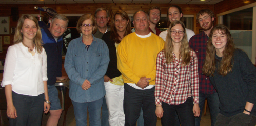
Ron Lipp is a dedicated member of The Casperkill Watershed Alliance and longtime resident of Hagan Town.  We talked with him on June 18th about his experience living in the watershed and working with the CWA.

Liz Jones: How long have you lived in the watershed?

Ron Lipp: I’ve lived here for 22 years.

LJ: In the same house?

RL: In the same house. We moved here from Ann Arbor, Michigan. One of the things that attracted us to the house that we live in was its location on the water. It made it very attractive and it was in the school district that we wanted.

Nadine Souto: What role did you envision the stream playing in your life at that point?

RL: Well, when you see a house with water… to me it represents beauty, serenity, a peaceful setting to enjoy. We have a deck at the back of our house and that deck is a highlight because we can sit out there and enjoy the stream and all the wildlife that goes along with it.

LJ: Has your perception of the stream changed since you first moved here?

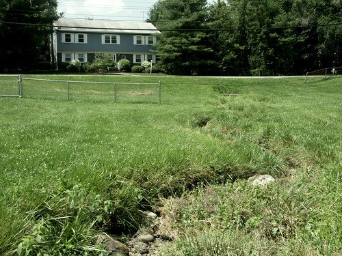
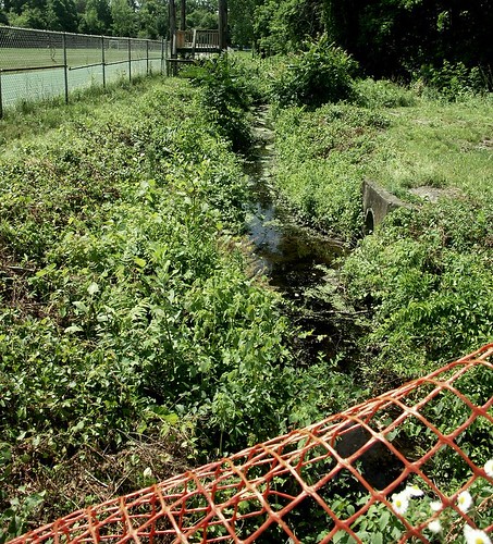
RL: I have observed significant erosion on the other side of the stream, on our neighbor’s property, since the storm drain empties into the creek right behind our house. There is significant flooding of the stream with every significant rainfall. I have taken pictures many times when it floods and people will come to our yard to see if we float away.

LJ: Was that always the case or did that start after a certain point?

RL: Our basement is probably 25 feet from the stream and that was a question I had when I bought the house. I asked the previous owner if she had had any problem with the flooding and she said that neither she nor the previous owner had ever had a problem. So, with that description, I felt reasonably assured.

NS: And has your basement ever flooded?

RL: Never. Although when we get significant rain, I wonder how much it would take.

The flooded Casperkill as seen from Ron Lipp’s backyard after a heavy rainfall in 1989

NS: How would you describe your relationship to the Casperkill? How do you or your family interact with it?

RL: I feel that we are part of it because we live on it and our property line actually goes through the middle of it. We have a double lot, so I would say that we have a significant portion of the Kill that we consider ours. It is not only part of nature and our neighborhood, it is part of our homestead.

LJ: Did your kids play in the stream?

RL: We didn’t encourage it, because we weren’t sure how safe that would be. There were occasions when we would see foaming material, colorful water and we weren’t sure where the contaminants were coming from and how serious they were. So we encouraged our children not to play in the stream, though it was pretty hard to keep them totally out.

NS: Did you ever get any official notification or information about the health of the stream?

RL: Never. I first learned about the health of the stream when I attended a watershed presentation at Vassar College about four years ago, when they shared the results of their study. That was confirmation enough for me not to have people go in it and certainly not drink it or expose oneself to the hazards of the water.

LJ: Did you see those kinds of things pretty much throughout or did it get worse at any point?

RL: It doesn’t happen too frequently, but once a year, on average, I see something in there that doesn’t look natural.

LJ: How did you hear about the Casperkill Watershed Alliance?

RL: Through the newspaper, when they announced that there was going to be a meeting at the college. I attended probably one of the first presentations by the faculty. Since I lived on [the stream], I was interested in it, and so I became aware of [the Alliance] and was probably one of its first members.

LJ: Why is that group important to you? Why do you keep going?

RL: I think I have become, because of the Alliance, more of an advocate for watersheds and their importance for the water supply and the environment. Through the Alliance, I learned that we as homeowners could take steps of our own to improve the health of the watershed, namely by reducing or eliminating our use of pesticides. And I made a significant change in our lawn care as a result of the knowledge gained through the Alliance.  Another thing that we are encouraged to do is to grow plants and leave grass long along the stream, which I have done personally and encouraged neighbors to do. For example, the neighbors behind us, where I observed significant erosion, I not only recruited them to participate in the Alliance but also encouraged them to leave the grass long and make plantings to prevent further erosion.

LJ: How long ago was it that you started doing those things?

RL: Well, since I’ve been with the Alliance, I have been advocating for the plantings. This year was the first year that I made a change in my lawn care, because, while I volunteered to be an advocate for the watershed, we created a one-page flyer that could be used in neighbor-to-neighbor campaigns and one of the first suggestions says ‘reduce or eliminate the use of pesticides.’ That’s when I realized that if I’m going to be an advocate, I have to practice what I preach. So as a result of that, I requested of my lawn care company that they use only organic or natural substances, which they have complied with.

NS: And have your observed any direct results of that, in terms of the health of the stream?

RL: Of course not, but I feel much better about it. And I have learned to accept dandelions as part of my environment. So, my new motto is ‘dandelions are beautiful.’

LJ: Do you have any other specific memories of the stream?

RL: As I mentioned, we really enjoy the wildlife associated with the stream. There is a large flock of mallards that live in and around the stream year-round. And I suspect by our feeding them, we’ve assured that they’ll stay close-by. And that is enjoyed by our children and neighborhood children who love to come by and feed the ducks. There are also some Pekins that are here, not because they are native but because families, around Easter time, buy ducklings for their kids.  When they outgrow their little cages and wading pools, they get deposited in a body of water and become domesticated to our neighborhood.

NS: Going back to your involvement in the CWA, what is your vision for the future of the Alliance? What role do you think it can play in the community?

RL: Well, my approach would be to do it one neighbor at a time. I think through targeted mailings and continual recruitment of people who live on or near the Kill, we could continue to educate and inform and encourage people to promote its health.

NS: Are there any other values that you see in the Casperkill, either for yourself or the community at large?

RL: I’ve seen children fishing in the stream. I’ve seen people coming to observe the wildlife, the frogs, the turtles, the fish… But another benefit to working with the Alliance is collaborating with faculty and students at Vassar College who also have interest in the environment. It’s made the whole project more stimulating and challenging.

Photographs courtesy of Ron Lipp.

Dutchess Watershed Awareness Month Ribbon-Cutting. 06/25

The ‘watershed spirit’ cut the ribbon at Friday’s Dutchess Watershed Awareness Month kick-off event at the Mid-Hudson Children’s Museum.  Members of the Regional Chamber of Commerce, the Mayor of the City of Poughkeepsie, and various councilmen from the City of Poughkeepsie were also in attendance.

July is Watershed Awareness Month and the Dutchess Watershed Coalition, in partnership with Cornell Cooperative Extension and several other local environmental organizations, has organized over 40 events including creek clean-ups, film screenings, history walks, birding walks, rain barrel building workshops, and science workshops.  All of these activities are aimed at increasing public awareness of watershed issues.

What is a watershed?

Watersheds are tracts of land in which all of the water that falls onto the land (i.e. rain, sleet, snow, etc.) drains into a single outlet, often a stream or river.  A healthy watershed provides recreational opportunities and critical ecosystem services, including reducing the intensity of floods, recharging groundwater aquifers (which provide water for groundwells), and supporting biodiversity.  Everyone lives in a watershed and the actions we take on land impact the water quality of our streams, rivers, and lakes.  To learn more about watersheds in Dutchess County, and to find out which watershed you live in, please visit http://www.dutchesswatersheds.org.

There will be several Dutchess Watershed Awareness Month events in Poughkeepsie to celebrate the Fall Kill and Casperkill watersheds:

–       Thurs., July 1, 7:00 pm. Film screening of “the Lorax” and “Swim for the River” at the Children’s Media Project (20 Academy St., Poughkeepsie).

–       Tues., July 13, 4:00 pm. A walk along the Fall Kill to the Walkway over the Hudson with City Assistant Engineer Joe Cheiner and local historian Harvey Flad.  Meet at the corner of Washington St. and Brookside Ave., Poughkeepsie.

–       Thurs., July 15, 7:30 pm. Film screening of “Flow” and selections from “A Journey in the History of Water” at Café Bocca, 14 Mt. Carmel Place, Poughkeepsie.

–       Fri., July 16, 5:30 pm. A walk and discussion with archaeologist Lucy Johnson about the Native American presence in the region and the importance of tributaries and springs.  Meet at Maple Grove Historic Site, 24 Beechwood Ave., Poughkeepsie.

–       Sat, July, 8:00 am. Ralph T. Waterman Bird Club Walk at Vassar College Farm and Ecological Preserve.

–       Sat, July 17, 1:00 pm. Rain Barrel Building Workshop at the Fall Kill Partnership Gardens (29 North Hamilton St., Poughkeepsie).  Rain barrels capture runoff from rooftops during storms to use later to water your lawn or garden.  There is a $15 fee and spaces are limited—if you are interested contact Vicky Buono at vcb4@cornell.edu or (845) 677-8223 x153

–       Any time in July.  Adopt-a-spot! Organize a clean-up in your neighborhood. Creeks, parks, parking lots, and schools are all good spots to adopt.  Contact Stephanie Cabey at Stephanie.Cabey1@marist.edu if you are interested, and she will provide you with cleaning supplies and Dutchess Watershed Awareness Month t-shirts.

–       TBA.  Oral History of the Casperkill night at Vassar College.  A walk with the Oral History of the Casperkill team to discuss the history of the Casperkill watershed.

For a full list of events, check out the Dutchess Watershed Awareness Month website: http://dutchesswam.com.

Spackenkill

The Spackenkill was once a very small watershed adjacent to the Casperkill watershed.  Today, the headwaters of the Spackenkill creek are actually within the Casperkill watershed. The picture above shows the dry creek bed leading up to Hagan Drive.

While Nadine and I interviewed Fran Hartenfels about her experience living along the Casperkill, Fran’s friend Michelle McGinnis stopped by.  Fran told us that Michelle lived nearby, and that a creek also went through Michelle’s backyard…

Fran: What do they call it? A kill or whatever.

Michelle: A drainage ditch?

Fran:  No. It’s part of the watershed.  (Turning to me and Nadine) What do they call it?

Michelle: It’s a drainage ditch, not a watershed!

Fran: No, honey, it’s not a drainage ditch!”

According to Michelle, a homeowner living along Pasture Lane, the Spackenkill creek only really has water in it when it rains.  The rest of the year the creek-bed is mostly mud with only an occasional trickle of water.

Although the creek might seem like a drainage ditch most of the time, three or four times a year there are rainstorms big enough to cause the ponds at the McCann Golf Course to overflow.  The Spackenkill swells so much that it floods Hagan Drive and pours into the (usually dry) creek bed between Miron Drive and Pasture Lane.  This deluge brings tennis balls from the Spackenkill High School courts and a whole host of other do-dads and trash articles into nearby backyards.  Michelle told us that when her children were young, they used to fish for trout in the creek and put on floaters to “run the rapids.”

Michelle’s story reminds us that even though the Spackenkill is usually inconspicuous, it is still an important resource that we should seek to draw attention to and protect.  The Spackenkill and other tributaries of the Hudson River  are often very hard to detect.  Without consulting maps and other resources even trained scientific researchers have a difficult time differentiating between what we might consider “drainage ditches” and tributaries.  One important thing to keep in mind when attempting to tell the difference, is that the distinction is actually less important than it might seem.  Even things that we traditionally think about as “drainage ditches” all eventually empty into our streams, and ultimately into the Hudson River.  Poughkeepsie gets its drinking water from the Hudson, so it is important to try to prevent trash, chemicals, and other harmful things from entering any waterway.

Spackenkill at Spackenkill High School
The Spackenkill flowing alongside the Spackenkill High School track.

Photo credit: Nadine Souto

Touched_Casperkill_1891_Reynolds_copy

The Spackenkill was once a very small watershed adjacent to the Casperkill watershed.  In the early 1900s the Spackenkill was referred to as Specken zyn kil (number 11 in the 1891 map above). At that time, the creek was much larger and it flowed all the way from the Spackenkill High School area  to the Hudson River (number 12 above).  Today, the headwaters of the Spackenkill creek are actually within the Casperkill watershed, but the–now separate–lower reaches of the Spackenkill still drain into the Hudson east of Route 9.

The following definitions were taken from Helen Wilkinson Reynolds’ 1924 book Poughkeepsie: The Origin and Meaning of the Word.

Speck zyn kil. Speck his brook.  Name given to a small stream that rises in a spring, opposite the Specken Kill school-house, and flows west to the Hudson.  Speck was an Indian who lived in the neighborhood.  Speck zyn kill was corrupted by English-speaking residents into the present form: Specken Kill (now Spackenkill).”

Another source (Adams, Arthur G. The Hudson River Guidebook. 1996) mentions that the Speck zyn kil emptied into the Hudson at Ganse Bocht, or Goose Cove.

From the Reynolds book:“Ganse Bocht: Goose Cove.  Name given to a small indentation in the east shore of the Hudson, south of Rudco and north of Camelot.  Ganse Bocht carries its own suggestion of the abundant wildlife in the Hudson Valley in the colonial period.”

Today, few people know that “the Spackenkill” is a creek—they think of that name mostly in association with the Spackenkill neighborhood and the Spackenkill High School.  The Spackenkill is still a creek though.  It runs from the McCann Golf Course under Hagan Drive and into the Spackenkill neighborhood.  The lower reaches can be seen beyond the Eastern Mountain Sports and other stores along Route 9.

Information and 1891 map from: Reynolds, Helen Wilkinson. Poughkeepsie: The Origin and Meaning of the Word, Volume 1. Poughkeepsie, NY: Collections of the Dutchess County Historical Society, 1924.

When Nadine and I approached Chris Scott, his dog Pebbles was frolicking happily in the Casperkill.  Chris, a resident of Meadowview Drive, told us that whenever he is home (he currently attends college in Virginia), he and Pebbles frequent Hagantown Park.  Pebbles is particularly fond of swimming in the stream and eating the stream-side vegetation; “I think it cleans her teeth,” Chris explained.

Chris said that when he was a kid, this site along the Casperkill was one of the best ‘wild’ places for him and his friends to play.  Chris fondly recalled how they would play war games with different “bases” along the creek.  “Red Hawk versus White Hawk…it was like Vietnam or something.”

In addition to serving as a fun play area for neighborhood children, this little-known access point to the Casperkill is also home to variety of wildlife.  Chris told us that he is always finding new weird bugs.  Another neighborhood resident, Fran Hartenfels, told us that her kids always come to the site in the spring to look at the tiny frogs emerging from the pond adjacent to the stream.  When we visited the pond with Fran, this blue heron was wading in the green algae.

Bearing Site from Rail Trail
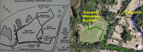
The abandoned Schatz Federal Bearing Company waste disposal site can be seen from the Rail Trail.

The Schatz site is located along Van Wagner Road, at the edge of the Casperkill watershed.  The site was originally a marshy wetland until extensive landfilling by the Schatz Company completely changed the topography of the area.  Five of the site’s twenty-two acres were filled in, and the site is now mostly flat with two small hills.

In 1949, when the Schatz Federal Bearing Company built a plant to manufacture ball bearings for industrial applications in downtown Poughkeepsie, the Schatz Co. also developed a site along Van Wagner Road to satisfy their disposal needs.  Wastes dumped at the site included: cutting oils, lubricants, grinding sludges, solvents, coolants and metal parts, as well as municipal and slag wastes.  By 1973 Schatz had discontinued dumping at the landfill, and a New York State Department of Environmental Conservation (NYSDEC) inspection the following year revealed no environmental hazards—the refuse had been covered with soil, and no leachate was found.

In 1979, however, a rust-colored leachate was observed entering the Casperkill, and the NYSDEC recommended that the site be re-graded to divert rainfall away from the landfill area.  The following year, a NYSDEC study indicated soil PCB concentrations that exceeded EPA maximum contaminant levels.  Further study of the site found leachate in the bank next to the creek, and a NYSDEC water analysis in 1983 found high concentrations of chlorinated ethenes.  This finding resulted in the NYSDEC designating the Schatz site as “In-Place Toxic Site #314003,” leading to some site clean-up.

Although the Schatz site has been re-graded so that the Casperkill no longer runs through it, very little is known about the waste history of the Schatz site, or the current environmental status of this privately owned land.  No records from the company are available and the air photos that originally determined that dumping had been occurring at the site represent only six days out of a twenty-four year waste history.  This makes it difficult to know exactly how long the contaminants from the Schatz Federal Bearing dumping site will persist in the environment, and the extent to which they will continue to negatively impact the Casperkill.

This site, as well as the nearby FICA landfill and Route 44 municipal dump, demonstrate what little foresight was used when constructing waste sites outside of Poughkeepsie in the mid-1900s.  Perhaps it seemed like a good idea to dump municipal and industrial wastes out along Van Wagner Road when the majority of the region’s population was concentrated closer to the Hudson River in the City of Poughkeepsie.  However, recent population increases have resulted in the gradual expansion of the suburbs, such that there are residences even on the Schatz site itself.

Schatz Federal Bearing Site

Map of the site as a dump (1950-1970), and map of current Casperkill watershed.  Today the Casperkill watershed partially skirts the dumping site; this is due to the re-grading of the landfill area in the 1980s.

Information and map from: Metal Contamination of Surface Sediments in the Casper Creek Drainage System, James G.D. Peale, Dept. of Geology, Vassar College, 1991.

Photograph by Nadine Souto


This 2000 map shows the altered course of Raymond Avenue as a result of the 1965 realignment, which caused the sacrifice of trees and the filling in of about 75 feet of Vassar Lake.

Raymond Avenue hasn’t always had the center median and roundabouts it is outfitted with today. Rather, it has undergone several transformations over the past century.  While most local residents will remember the controversial 2007 renovation, fewer will recall the equally contentious reconstruction that took place in the 1960’s.

Prior to the 1960’s, Raymond Avenue was a curved, two-lane road flanked by trees and shrubbery. In 1961, however, the New York State Highway Department began planning a radical reconstruction. Raymond Avenue was to be realigned and expanded and Hooker Avenue was to be widened, so as to accommodate increasing road traffic in the Town and City of Poughkeepsie. These plans were met with disapproval on the part of Vassar College authorities, who feared the changes would have a negative impact on the aesthetics and safety of the campus. The following excerpt from an October 1961 resolution issued by the Board of Trustees sheds light on the college’s concerns:

…such a reconstruction would (a) create a major traffic barrier between the academic buildings and student residences to the east and the faculty residences and Alumnae house to the west, (b) would create hazards to students, to faculty and to faculty families in their normal and necessary access to one another, (c) would involve congestion and danger at the main and service entrances to the College, (d) would materially and adversely affect the further development of the Faculty Housing Area south of Vassar Lake, (e) would involve the destruction, and render impossible the replacement of many shade trees along Raymond Avenue, and (f) would, by projecting a major traffic artery through the campus, destroy the working pattern, the amenities and the traditional homogeneity which has developed over a period of one hundred years…

These risks were taken very seriously by the Board of Trustees, who a year later agreed that “everything possible will be done to negotiate a more satisfactory solution than presented in these plans including, if necessary, conference with principal state officials.“ At the same time, however, they were aware that the State Highway Department had the power to carry out its plans regardless of the position taken by the college.

Eventually, in 1964, the reconstruction plans were finalized with only minor changes to the original.  Interestingly, one of the items of greatest concern to the Board of Trustees was the removal of all trees on the east side of Raymond Avenue. In order to address this, it was agreed that new plantings were to be done by the State with the approval of the college. It was stressed that “the greatest care must be taken in the selection and proper planting of trees and bushes with particular foresight as to their future growth.”

Raymond Ave 2006

In 2007, Raymond Avenue was turned back into a two-lane road, this time with a center median, a sidewalk and three roundabouts. First proposed in the year 2000, the project was designed by the Department of Transportation in response to concerns regarding the safety and efficiency of Raymond Ave. The median and roundabouts were to allow for more pedestrian-friendly traffic, while keeping the flow of vehicles constant.

The 2007 reconstruction plan, a pilot project in new traffic design that could be expanded if successful, was also met with disapproval, this time by local residents who feared that the roundabouts would divert traffic into nearby neighborhoods. These suspicions were eventually disproven and the project completed. And although some bemoan the lack of bicycle-friendly infrastructure, the overall result is slower traffic and safer conditions for pedestrians.

Sources:

February 1961- October 1964 Vassar College Board of Trustees Meeting Minutes, Vassar Special Collections

Sutherland, Lauren. “Raymond Ave construction debate continues,” The Miscellany News, March 3, 2006

Nigro, Jenny. “Mixed Reviews for Revamped Raymond Avenue Construction,” The Miscellany News, February 1, 2007

Image credits:

“Overlay of 1925 landscape and 2000 landscape” by Dorothy Wurman, 2000

S. Rosen-Amy, The Miscellany News, 2006

Picture 1
A map of Lake Dwight from Marlyn Magnus’ 1957 thesis.

In 1957, Vassar student Marlyn Mangus completed a senior thesis in Geology in which she identified and mapped the boundaries of a glacial lake that formed in front of the retreating Laurentide ice sheet.  This lake, which she named Lake Dwight, is thought to underlie much of the town of Poughkeepsie, stretching from the Peach Hill Park area north of the Vassar Campus southward to Spackenkill Road.

Continental ice sheets covered much of North America and northern Europe during the Pleistocene (2.588 million to 12,000 years before present). As the earth warmed and these glaciers retreated, they eroded land away and in some cases left behind glacial lakes.  When glaciers retreated, blocks of ice were sometimes isolated from the ice front and were left near the lower reaches of valleys. The ice blocks acted as dams, impounding water in the valleys until the ice klaved off and the lakes could drain out.

In her 1957 thesis, Marlyn Magnus proposed that this sort of thing occurred in what is now the valley of the Casperkill:

Ice blocks must have been isolated from the main ice front and left below what is now Spackenkill Road, forming a dam and backing up the water as far as Bedell Road.  Thus a lake was formed which has been named the W. B. Dwight Lake.  Streams running into the lake brought material, which was deposited on the floor of the lake.  Eventually the ice blocks melted, leaving klaves (which can be seen south of the Spackenkill Road), and the water drained from the lake.  A stream, the Casperkill, developed upon the old lake clays, and it is this stream which now drains the valley.”

About 50 years after Magnus first proposed and mapped Lake Dwight, students in a paleoclimatology class at Vassar College proved its existence.  The students analyzed a 33 meter-long sediment core from the Vassar Farm (thought to be in the middle of the glacial lake) looking for pollen, evidence of trees, grain size (size can tell us where the water was coming from…whether the core was in the middle of the lake or at the edge of the lake), and other organic material.  Emily Vail and I sat down to discuss what the class found:  “All we found the whole way down, aside from some sand and iron at the surface, was (drum roll please)… grey, Gley, clay”

Not very exciting…but it did prove that Lake Dwight existed, and that it was pretty large and long-lived.  All that clay was deposited while the lake was around.  Vail told me that the class was still a great experience, and that it gave her a very different perspective on the landscape:

Thinking about time frames like the Pleistocene was just really far out for me.  That’s a really long time ago.  And it was amazing to go back and look at this thesis, and to think about what this place looked like during the ice age.  To think about how with the Casperkill…we have a big valley out there.  Why does it look that way?  Well, partially because of Lake Dwight, and partially because the Casperkill has come in after the Pleistocene.”

We are often reminded of how the land affects us: how it affects vegetation cover, where we develop, the kinds of things we might do in a particular area.  But by imagining Lake Dwight we are encouraged to think about something that we almost never consider.  That is, how land is actually formed, how it came to look the way it does.

Information and map from: W. B. Dwight Lake, Dutchess County, New York, Marlyn Mangus, Dept. of Geology, Vassar College, January 1957

Personal interview with Emily Vail, June 11, 2010.


Picture 3


The Casperkill Watershed Alliance on June 9, 2010

The Casperkill Watershed Alliance is a partnership between the Vassar Environmental Research Institute (ERI), Cornell Cooperative Extension Dutchess County (CCEDC) and Casperkill Watershed residents, civic officials, and other interested parties.  The alliance meets monthly and organizes various community watershed events such as streamside plantings, storm drain marking projects, creek cleanups, natural lawn care workshops, rain barrel workshops, bike rides, and more.

In the spring of 2006, student and faculty researchers from Vassar College’s Environmental Research Institute began monitoring the water quality of the Casperkill Watershed on a monthly basis.  After two years of conducting research on the health of the stream, researchers began to recognize that it was important to get information about these topics out to the general public.  After two public forums and feedback from a stakeholder survey, there was enough momentum to start a citizens group—the Casperkill Watershed Alliance (CWA)—in 2008.  The CWA is led by Vassar College’s ERI Collins Fellow; a position that changes every year and is filled by a recent Vassar graduate who majored in Environmental Studies or a related field.

This kind of relationship between an academic institution and the local watershed group is fairly unique, as most groups are affiliated with the local government.  And although there are many ways that a watershed group can be successful, this arrangement seems to be working well for both parties.  The CWA certainly benefits from having Vassar College as a parent institution: not only does this provide access to important contacts, but it also ensures that the CWA has a paid director—something that is becoming less and less common in these hard economic times.  To get a sense of how Vassar College benefits, Nadine and I spoke with Emily Vail, the current Collins Fellow, about why the creation of the CWA was so important for the Vassar College Environmental Research Institute. She emphasized that although Vassar researchers can conduct experiments and gather data to their heart’s content, it is ultimately community members who must “actually take steps to improve the water quality.”

Additionally, Vail discussed how leading the CWA has changed her own perception of watershed issues for the better.  “Looking at the creek as a researcher is completely different than looking at the creek as a citizen, or as a politician, or as a planner.  That’s one of the cool things about the Collins Fellow position.  At any one time you could be wearing all of these different hats.  It’s been a huge learning experience to know what motivates people.  Why do they care, why do they show up to this event, what can I teach them?  Maybe it’s just saying, ‘that drainage ditch is in fact the Casperkill creek.’”

Responding to citizen concerns has also led the ERI to take on science research projects that they might not have otherwise.  For example, Vail spent a summer doing research on bacteria in the creek.  “When you look at the stakeholder survey one of the things that people are most concerned about is sewage in the creek.  That’s something that community members really care about, but that’s something that’s not going to get published (because we already know the environmental consequences of high bacteria levels).  But in the Casperkill its important to know, OK, in this one location maybe someone has a leaky septic system because every time it rains it flushes something.  Or, maybe in this one section the city isn’t maintaining their sewer system properly; we should go in and check and make sure there isn’t a leak.  That has applications for municipalities, it has applications for landowners, but not in academic journals.”

***

It is the small size of the watershed, combined with this emphasis on issues that are most important to homeowners—leaky septic tanks and erosion in particular—, that makes the Casperkill Watershed Alliance so distinctive among other watershed groups. Although the small size of the watershed makes it hard to get the word out that the Casperkill Watershed Alliance exists, it also gives the Alliance a very friendly, neighborhood feel.  According to Vail, many of the people who attend the meetings are “not your typical stream activist people…they don’t fit that stereotype.”  Instead, most of them are people worried about their property… They enjoy the ‘folksy,’ laid-back, social atmosphere of the meetings.”  This kind of atmosphere is even encapsulated in the Casperkill Mission Statement, which was decided on at a meeting last week: “The mission of the Casperkill Watershed Alliance is to promote awareness, foster appreciation, and work towards improving the ecological health of the watershed in our neighborhood.”

The Casperkill Watershed Alliance holds meetings and organizes events on a regular basis.  For Meeting Agendas, Minutes and Events, see the Casperkill Section of the dutchesswatersheds.org Community Forum.  To be added to the e-mail list or to attend a meeting, please contact Emily Vail at emvail@vassar.edu or Stuart Belli at belli@vassar.edu.

Casperkill Around Town

Several places around Poughkeepsie have borrowed the name Casperkill

The name Casperkill does not refer to the creek alone. In fact, it comes up fairly often around Poughkeepsie. We did a tour of the watershed and found several places named after the Casperkill.

The following excerpt is from a 2008 Poughkeepsie Journal article by Kelsey Smith, former Collins Research Fellow and the first coordinator of the Casperkill Watershed Alliance:

“The Casperkill headwaters emerge in a swamp on the north end of Poughkeepsie near the base of Peach Hill.  From there, it flows through or marks the boundary of every town board member’s ward.  In a disparate town with many centers, the creek is a feature tying us all together.

We have Casperkill Drive, Casper Creek Road, the Casperkill Golf Club — and yet many residents would be hard pressed to tell you where the creek actually is.  The Casperkill, for its natural beauty and commercial potential, is both under-used and underappreciated.”

If you know of any other places named after the Casperkill, feel free to leave a comment or send us a picture.

Excerpt from:

Smith, Kelsey. “Hope remains for a clean Casperkill.” The Poughkeepsie Journal 22 July 2008: 6A.

Photography by Nadine Souto and Liz Jones

« Newer Posts - Older Posts »

Social Widgets powered by AB-WebLog.com.