Health of the Casperkill, Part 3: Land Cover and Use
August 2, 2011 by admin
One of the many reasons the Casperkill Watershed is so special is its diversity in land cover and use. The Watershed is made up of wooded, impervious, grass, fallow, and water land cover; and land use ranges from commercial to urban to farm to suburb to rural to the Vassar college campus. This diversity makes the Casperkill Watershed an excellent setting to study how different types of land use and land cover affect stream health.
Of the watershed area, 43% is forested, 33% is covered by impervious surfaces (including the Tilcon quarry site, since the runoff potential of bare stone is close to that of impervious surfaces), and 19% is grass (which includes open fields, lawns, and golf courses). The last 5% of the watershed is bodies of water and fallow areas.
The Foteynkill subwatershed is the most urbanized part of the watershed, made up of 70% impervious surface. This portion of the watershed drains parts of the City of Poughkeepsie.
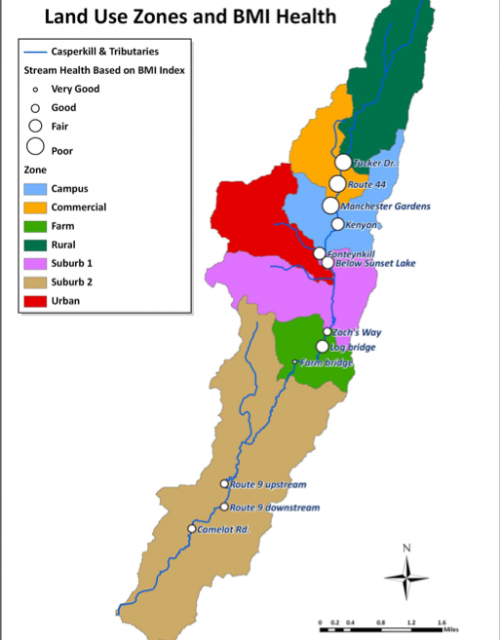
Many studies have demonstrated a connection between land cover and the health of aquatic ecosystems. Different types of land covers can determine whether a watershed is deemed “healthy” or “unhealthy.” Studies of the benthic macroinvertebrates at 12 different sites along the Casperkill Creek showed the most impairment of the ecosystems in the commercial land use zones–by Tucker Drive, Route 44, and Manchester Gardens. Water quality improved downstream as the Casperkill entered suburban, rural, and farm land use zones.
Each site that was tested is depicted by a white circle; the bigger the circle, the poorer the health of the benthic macroinvertebrate community. Healthier sites have higher populations of BMI families that are more sensitive to pollution, including Caddisfly larvae, Hellgramites, Mayfly nymphs, Gilled snails, Riffle beetles, Stonefly nymphs, and Water pennys.

