Feed on
Posts
comments

The Fall 2018 version of this 6-week course has come to an end.

We visited

  • the Appalachian Trail at Nuclear Lake,
  • the historic house properties of Locust Grove, Maple Grove, and Springside,
  • Matthew Vassar’s grave at the Poughkeepsie Rural Cemetery,
  • the Slabsides cabin of John Burroughs,
  • the cemeteries of the Ulster and Dutchess County Poorhouses,
  • the Innisfree Garden,
  • the Scenic Hudson park at West Point Foundry,
  • the waterfront of Cold Spring,
  • the Cary Institute for Ecosystems Studies,
  • and the Millbrook Tribute Gardens.

The students discussed their experiences at these places and came up with their top 4 places where the complexity of the Hudson Valley’s green spaces can best be experiences. Their brochure is linked here. ENST291 Fall 2018 Brochure

Cary Institute

The Cary Institute’s campus is spread across approximately 2,000 acres in the Hudson Valley of New York.  The institute’s buildings consist of a research complex, analytical laboratories, an environmental monitoring station, classrooms, an education department, and an auditorium. These grounds function primarily as a laboratory for field research and for extensive research on the ecology of Lyme disease. The grounds also contain hiking trails accompanied by interpretive kiosks covering topics ranging from wetland protection to environmental conditions and their effects on Lyme disease risk.


Trails:

Cary Pines Tail

The Cary Pines trail stretches 1.3 miles and looks on a wooded meadow full of white pine that inspired the trail’s name. The trail divides half way, with the second path leading to the roadways


Wappinger Creek Trail

This 1.25 mile trail runs along the Wappinger creek under a thick canopy to create a cool dark forest filled with sugar maple.

EdVenture Trail

This “educational adventure” trail acts as a tool for students and visitors to investigate environmental factors impacting our forests such as deer browsing, farming, glaciers, and lightning.

Sedge Meadow Trail

The Sedge Meadow trail runs on a small boardwalk to cut through a stand of red maple in it’s namesake sedge-hummock wetland.


Another area of the grounds, the Fern Glen, is a two-acre display consisting of native plant communities making use of a pond, a meandering boardwalk, a pond, and an observation deck with a view of Wappinger Creek. The Glen acts as a location where nature is available to stimulate all your senses. The Cary Institute’s Ecology Camp allows children the opportunity to be in this environment and connect science concepts learned in the classroom with real-world examples and application. Visitors also walk along paths where one can see an active hummingbird community sip nectar from flowers, spot painted turtles sunbathing on a log, or learn to identify spore patterns on the local ferns.


The Cary Institute

Recently we visited the Cary Institute of Ecosystem Studies in Millbrook, NY, which is a leading institution for environmental research. They are a “living lab to study ecological processes”, with 2,000 acres of property, and 15 full time scientists on staff. We met with one of their scientists, who told us about the history of the institute. The property was originally owned by Mary Flagler Cary who with her passing in 1967, left her land to a charitable organization. For some time, the property was a botanical garden/arboretum. Later in 1983, the Institute of Ecosystem Studies (IES) was established, and became the start of what exists today.

Today the IES has many long-term research projects. Some include; freshwater health, infectious diseases, urban ecology, invasive species, climate change, and biogeochemistry. One of their main focuses is controlling the deer population on the property. Deer population can double in two years if left untouched. Therefore a few decades ago, the IES started a hunting program, with an emphasis on hunting female deer in order to help regulate the population. Deer are very harmful to an ecosystem, given that they eat large quantities of vegetation. IES also is currently focusing on tick research, in order to study the effects of infectious diseases.


Besides research, the Cary Institute also has connections with the outside world. They allow outside researchers to use small parcels of their land for field studies, and they have 2.7 miles of hiking trails for public use. The hiking trails are open April 1st- October 31st, and then the hunting season follows. On the trails you can find many signs teaching you about various things in your surroundings, such as frogs, plant species, and ticks.


Additionally many different vegetation habitats exist on the property, and they also have a Fern Garden. The Fern Garden helps one remember the history of the property as a botanical garden. The Cary Institute allows one to connect with nature, and have an educational experience.


West Point Foundry

The West Point Foundry Preserve was a functioning iron factory through the 19th century and served as an important site of artillery production during the Civil War. In 1911, the site was abandoned and lay in waste for almost a century, used as a dump site for Cold Spring residents and a battery factory that was located on site.

Touring the site now, you would not believe that the place had once been a grimy, hot, factory, let alone a cadmium polluted-dump. Once Scenic Hudson took over in 1996, they made quick work to dispose of the polluted soil (by moving it elsewhere), construct paths, and restore the remaining office building (bel0w), spending millions of dollars on restoration.

Now the site is a pristine, well-maintained park. The forest is pretty typical of a new-growth stand with some invasive underbrush, but the trails are well marked, and there are a series of elaborate interpretive signs and sculptures along the trails. Our guide, Reed Sparling, called the park a sort of “outdoor museum” which becomes obvious when you reach the exhibits on the Parrot rifle and water wheel (pictured below). Both have large re-creations of the structures as well as detailed interpretive signs explaining their historical significance.

The surrounding town of Cold Spring, which used to be primarily a working-class factory town, has now seen a rapid increase in property values, likely in conjunction with the construction of the West Point Foundry Preserve, the Foundry Dock Park and other green space initiatives nearby. While Scenic Hudson has done a great job with preserving this particular piece of history, military history is already well-funded when it comes to preservation. I wonder what groups like Scenic Hudson could do if they dedicated their funding toward lesser-known histories, such as those explored at the Dutchess and Ulster County Poorhouses. While the park is beautiful, and is a model in terms of ecological restoration, I wonder if it is worth the gratuitous funding and doubtless maintenance that goes into this park rather than community-building and social initiatives to help folks like those who would have actually worked at the foundry in its day—many of whom were immigrants working wage labor.

Scenic Hudson is an organization whose mission is to expand the public’s access to some of the most beautiful and at-risk land in the Hudson River Valley. At the West Point Foundry, one of the organization’s historic sites, we met with a member of their communications team named Reed Sparling. He shared with us that his organization, now employing a team of over 50, started as a group of 6 activists with a singular mission, protecting Storm King Mountain from a hydroelectric project. It was a grassroots effort striving to get the whole community involved, but always prioritizing science and experts to provide the most effective rhetoric possible. He highlighted the considerable ambition and bravery it required to challenge an energy company in the 1960s and how this courageous spirit has guided the organization to this day. Today Scenic Hudson’s properties are a mix of 60 parks, preserves and historic sites.


The old office of the West Point Foundry.

The West Point Foundry project is a good example of the expanded mission of Scenic Hudson and their diverse offerings to the community. Reed said the park was designed as an “outdoor museum” to simultaneously preserve the industrial history of the region, allow the land to recuperate from the major pollution that had once taken place there, and provide a place for locals to enjoy and celebrate their natural surroundings. As is a theme with almost all of the parks we’ve visited in this course, despite the grand aspirations of those who plan them, the most visible use of the land was for dog walking, but this in no way to disqualifies the way these sites enrich those who visit them (and their dogs).


A view of the old dam of the West Point Foundry.

After visiting the foundry, we drove into Cold Spring to explore the town and get some ice cream. As we walked to a paved riverfront park with our ice cream cones and sundaes, we were surprised to see a Scenic Hudson logo on the gazebo along the curb. Across from the park was the iconic Storm King mountain the organization was founded to protect. It dawned on us the overwhelming reach Scenic Hudson has on our local landscape and outdoor community. I for one am grateful we have people like Reed dedicating their professional lives to keeping the Hudson Valley beautiful and accessible to all. As is demonstrated by the fight for which they were founded, without organizations like Scenic Hudson we are often left to the whims of powerful people and corporate interests who don’t understand the aesthetic, environmental and historical values central to a communities health and prosperity.

Storm King Mountain from Cold Spring’s riverfront park.


Scenic Hudson, the environmental organization that has protected over 45,000 acres in the Hudson Valley since its inception, didn’t start out nearly quite so large. Indeed, it started as one of the first grassroots environmental movements. When Con Edison proposed installing a hydropower plant at Storm King Mountain, just up the Hudson River from Cold Spring, most small local environmental groups were not willing to jump into a fight against the major utility company they felt they couldn’t win. However, six individuals from these various groups came together to form the Scenic Hudson Preservation Conference in 1963, gaining grassroots support from the local community and researchers about the true environmental cost of the hydropower plant. Scenic Hudson’s court victory in 1965 gave local residents standing in court to fight the plant, which set the precedent for modern environmental law cases. In essence, the court agreed that local residents would lose more from the plant than the electricity anyone gained and set precedent for the process of citizen input into projects such as power plants.

View of Storm King Mountain from Scenic Hudson’s Foundry Dock Park Cold Spring

Con Ed continued trying to push through the plant at Storm King until 1980, and in the meantime Scenic Hudson continued taking on other projects aligning with their mission of preserving the Hudson River. While parts of the group wanted to pursue their conservation mission nationally, the organization remained focused on the Hudson Valley, and some people split off to form the National Environmental Defense Council. Scenic Hudson’s other work includes preservation of farmland from development; riverfront land for habitat restoration, river health, public recreations, and future impact mitigation of sea level rise; advocacy for PCB cleanup and against pipelines; and much more. In doing so they have acquired an enormous amount of land in the Hudson Valley, some of which they manage as their own parks as well as land that has or will be incorporated with State and National parks. One intersection of many of these goals is West Point Foundry Preserve, which required extensive remediation, and now couples historic and environmental preservation with ecosystem restoration.

The replica water wheel at West Point Foundry Preserve.

For more information, including locations of parks, see https://www.scenichudson.org

West Point Foundry

Our Field Experiences crew took advantage of a beautiful fall afternoon to tour the West Point Foundry in scenic Coldspring, NY. The West Point Foundry, now being reclaimed as a natural area/historic park by the Scenic Hudson group, was originally opened as an ironworks in 1817 to generate munitions for the then-fragile republic. As the production site operated over the following decades, its owners had little regard for the surrounding environment. The result, unfortunately, was a superfund site notorious for the world’s most hazardous cadmium dumping area.

It was in this situation that the folks at Scenic Hudson stepped in. The effort to regenerate the cite came with two goals: to document and preserve the historic relevance of the foundry, while promoting an environmental reclamation in keeping with Scenic Hudson’s vision of outdoor recreation.

The goal of historical preservation was done tactfully and with great care. Archaeological surveys of the areas surrounding the foundry yielded some 150,000 artifacts, which otherwise likely would have been lost. In addition to artifact collection, Scenic Hudson maintains the last remaining building of the foundry. The building (supervisors’ headquarters), which likely would have deteriorated both naturally and through vandalism, serves as a reminder of the rich history of the Hudson Valley.

Those responsible for the restoration, again with great attention to historical detail, constructed partial recreations of actual implements used in the foundry. Notably, a canon-testing apparatus and mill wheel.

With regards to the other goal of environmental protection and recreation, Scenic Hudson has done equally impressive work. After laboring extensively to clean up the site, they installed well-maintained systems of trails throughout the roughly 95 acre park. There are a variety of paths, catering to runners, hikers and bikers (some are even handicap-accessible). The trails allow for an appreciation for what reclaimed industrial land can offer. In addition, they provide access to some remarkable sights, only too common in the Hudson Valley. In that spirit, pictured below is a view of  the of the Hudson Highlands from the park, as well as waterfall along one of the trails.

Two places that our class visited over the past two weeks were the previous locations of the Ulster County and Dutchess County Poorhouses. Sadly, there are very few known details about those who lived in the poor houses outside of the actual locations of these sites.

Today, these two places share the same purpose: to bury the abandoned members of the poor houses with as much ambiguity as possible. However, while one of these sites attempts to distract visitors from its tragic history, the other attempts to shed light on its history in a confusing way.

The slanting fence and lone gravestone of the previous site of the Ulster County Poorhouse

This sign was relatively far from the actual burial grounds (which are under and around the playground and pool)

When we visited the site of the past Ulster County Poorhouse and its cemetery, we could not recognize it at all! Shockingly, it had been transformed into a playground, pool, and parking lot open to the public next to an encroaching forest. Additionally, there are neat beds of grass around the recreational area that make the history of the area even more forgettable. One of the only traces of the area’s history was an unmarked gravestone directly outside of the fenced playground’s perimeter. Also, the fence was sloping downwards at some points, which indicated uneven ground possibly due to the number of unmarked graves beneath the fence. After walking away from the recreational area and past some folded bleachers, our class found a relatively large sign giving the history of the poorhouse’s residents’ graves. Ironically, there is only one proper labelled grave that was most likely for someone who was related to the owners of the poorhouse rather than someone who actually lived in the poorhouse. Clearly, the previous location of Ulster County Poorhouse needs to do a much better job of respecting those who remain forgotten.

Comparatively, the site of the old Dutchess County cemetery was slightly more obvious in its respect for its unfortunate history. Behind the ruins of the old poorhouse, there were seemingly countless graves that were simply marked with either a small green flag or a little numbered peg. However, there are probably not many visitors due to the wilderness of the graves; there were even a few trees growing in the graves themselves!

A panoramic view of the graves of residents of the Dutchess County Poorhouse as well as others who were forgotten by society

One of the pegs indicating the existence of a grave

And while more graves were marked at this site compared to the site in Ulster County, these graves were very ambiguous with respect to individuals. This makes it even more confusing for those visiting without prior knowledge of the site. Thus, despite showing visitors graves that were somewhat-marked, this site does not do justice to the masses of people who remain unnamed in their graves.

The graves of both the previous Ulster County Poorhouse and the old Dutchess County Poorhouse have a lot of room for improvement. However, if we recognize and properly respect the residents who lived and died without a written trace, these places can become spaces of remembrance and contemplation.


In the 1600s and 1700s, the concept of poorhouses was brought over to America from England. Meant to house the poor and mentally ill – essentially anyone that couldn’t work or who wasn’t normal – these government-run facilities often had very low-quality living conditions and treated its people less than well. These poorhouses were meant to be self-sustaining, often built on farmland, where residents were taught how to be a “good American” by contributing to the work force of the community. Upon arrival, people’s personal items were taken from them, and their identities were lost, often never to be reclaimed. When folks passed away, their families and local people, not to mention the poorhouse administrators, didn’t care enough to offer a proper burial. As a result, hundreds of bodies can be found in the backyard grounds of these institutions, even long after the institutions have been demolished.

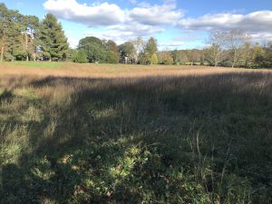
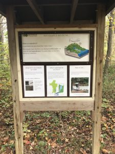
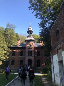
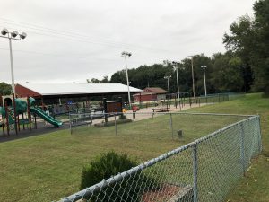
Last week, we were able to see the remains of an old poorhouse burial ground in Ulster County. Now public fairgrounds, the land still likely holds the bodies of hundreds of people that once resided in the poorhouse, though nearly nothing at the immediate site indicates their presence. With the farm houses still around to host county fair activities, and with a new swimming pool and playground complex that has been built right next to the burial grounds, it seems as if this piece of land is just like any other.

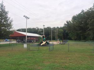
Ulster Country poorhouse playground

The only visible marker left behind is a single stone slab reminiscent of a headstone. This makes us question: why is there only one, and who did it belong to? Who were the other people buried, and why were they undeserving of remembrance? Although this stone slab is the only strong visual marker that this space may be a burial ground, archaeologists have been able to point out the slight depressions in the ground, indicative of collapsing coffins or decomposed bodies. This eeriness is only contributed to by the fact that a playground with fences dug deep into the ground looms immediately over the ground’s depressions. Much further away from this site lies a plaque and more formal gravestone commemorating Rebekah Maclang Brower, likely the caretaker’s daughter. This speaks enormously to the types of people remembered.
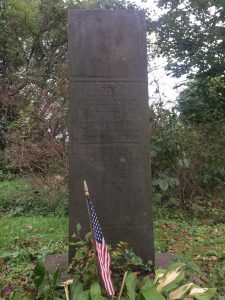
Rebekeh’s Headstone

Plaque by Rebekah’s Headstone

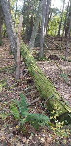
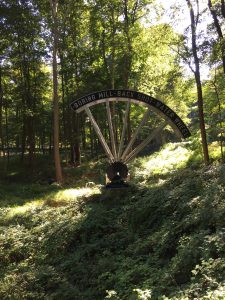
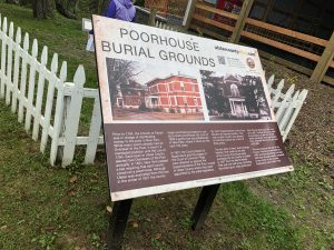
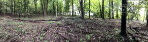
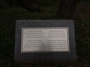
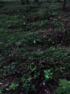
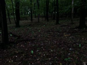
This week, our class visited a second poorhouse burial ground, this time in Dutchess County. Similar to that in Ulster County, only one headstone is present among the 800 people buried here, although this one exists hidden and tucked away. This burial ground differs drastically though, in that forestry was permitted to completely take over the burial ground, making the site look like an overgrown piece of nature rather than a developed and manicured lawn like that in Ulster County. The depressions in the ground here are much more visible and deep, making it clear that hundreds of people are indeed buried here, or perhaps some of their bodies were exhumed.

Depressions in the Ground

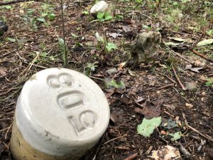
Cylinders engraved with numbers mark many of the graves, though none of them are named with more than a number.

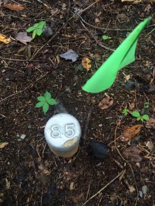
Cylindrical Grave Markers

The Department of Public Works is trying to make an effort to bring awareness to this space while hoping to transform the land into a proper cemetery by uprooting the trees and creating manicured lawns. The Department has recently received a proposal for an Eagle Scout project to commemorate 115 of the graves with long wooden stakes. However, it’s clear that nearly 7 times this amount of bodies are present, and striking wooden posts into the ground appears to be more invasive than anything else, while potentially useless if names aren’t identified to commemorate these people by. Perhaps by offering a bench for contemplation about the lives of these people and the institutional history that has contributed to their erasure would serve a better purpose, even if still in the midst of the forest’s overgrowth.

All the green flags indicate gave sites

These bodies are those of people who resided at the poorhouses, but also include unidentified and unclaimed people found dead in the region, as well as people considered not sacred, such as babies not yet baptized. Society has deemed them as unimportant by simply allowing their bodies to collect like this, abandoned and forgotten, and it is imperative that we make an effort to return honor to these people in death, because they never had it in life.

Innisfree Garden, located in Millbrook, NY is part of the scenic hudson valley. It was originally the residence of Marion and Walter Beck. The Becks began the garden designs in the late 1920s and later collaborated with landscape artist Lester Collins from Harvard University. This nonprofit foundation opened to the public in the year 1960 with the intention that it would be a place for the “study of garden art at Innisfree”. The trustees remind the public that it is a garden and not a park, and that it should be treated as such.

Information board at the entrance to the gardens

Innisfree Garden is a place where one can truly leave civilization and be surrounded by nature. When pulling into the driveway, you become aware of how separated you are from the industrialized world because the road appears to be never ending. Admission is $6 on weekdays, and $8 on weekends. The gardens are open to the public wednesday-fridays from 10-4, and saturday/sunday from 11-5. The garden is 185 acres and embodies Chinese design. It includes the renowned “cup garden” architecture.

A “cup garden” at Innisfree

“Cup gardens” are special because they highlight one object, so that it can be “enjoyed without distraction”. This enables a person to see the beauty of a simple item in nature. There are many cup gardens on the property and many routes around Tyrrel lake, with the intention that visitors enjoy the journey. You can spend hours here, taking a nice walk around the lake while observing Collins various designs. 

Besides for public enjoyment, Innisfree can also be rented for private events with a minimum property rental fee of $7,000 (for a group of 50 or less). Larger groups are also permitted at a higher rental rate. They also offer “Private and Commercial Photography and Film Shoots” (must contact for price) and groups tours (ranging from 12-50 persons) for $15 per person.

If you are looking to escape the noise and commotion of the outside world, Innisfree is a great way to be surrounded by nature and explore the Chinese “cup garden” design.


Older Posts »