Context is very important to Archaeology. Context is the relationship between artifacts. By looking at the relationships between artifacts, Archaeologists are able to learn about the history and recreate past events. Without context, it is impossible for archaeologists to create an accurate picture of the past. The history of Great Zimbabwe and its people is an example of the need of context to create accurate representations of the past using artifacts.
Great Zimbabwe is the ruins of a city located in the southeastern hills of Zimbabwe near Lake Mutirikwe. Great Zimbabwe was a city that existed approximately between the 12TH AND 15TH AD. It acted as the capital of the kingdom of Zimbabwe. The Zimbabwe civilization was one of the most significant civilizations that existed during the medieval period. The ruins are all that is left of a great trading civilization that existed in the interior of Africa. Zimbabwe controlled most trade throughout southern Africa. The city of Great Zimbabwe acted as a center for the trade of gold and ivory. The site began declining during the 15th century prior to being abandoned around 1450 AD.
The remains of Great Zimbabwe were first excavated by J. Theodore Bent and Cecil Rhodes. When Great Zimbabwe was first discovered, archaeologists did not understand what great Zimbabwe was or why it was abandoned. It was believed that the civilization of great Zimbabwe simply disappeared without a trace. As time passed, more information was discovered about Great Zimbabwe and archaeologists understood the context behind Great Zimbabwe. With more context Archaeologists about Great Zimbabwe, such understanding its role as the capital of the Zimbabwe empire and as a center of trade, it has become possible to develop educated theories about the decline and abandonment of Great Zimbabwe. With context, archaeologists have developed multiple theories explain the reason for the decline and abandonment of great Zimbabwe. Some theorists believed that changes in climate caused the abandonment of Great Zimbabwe. Another theory is that a decline in the abundance of gold and ivory in the area caused a decline in trade, this made Great Zimbabwe less viable as a place for the population to live. Some archaeologists believe that the decline of Great Zimbabwe was caused by the arrival of Europeans in the African continent disrupting trade.
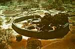
This Is an aerial view of the Great ZImbabwe Ruins
In the past it was thought that the inhabitants of Great Zimbabwe disappeared and that there was no traces remaining of the civilization other than the Great Zimbabwe ruins. Archaeologists did not conduct studies into populations that lived near the ruins of Great Zimbabwe. When archaeologists began studying the Shona population near the Great Zimbabwe ruins, they discovered that the population knew about the Great Zimbabwe ruins and were actually the descendants of the Great Zimbabwe civilization.
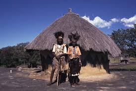
Shona People. Believed to be the descendants of Great Zimbabwe civilization
Great Zimbabwe is an example of the important role context plays in archaeology. Without context, it is impossible to create accurate depictions of the past. Context is what allows archaeologists to turn artifacts into theories about the past.
Further Reading:
http://archive.archaeology.org/9807/abstracts/africa.html
http://www.pbs.org/wgbh/nova/ancient/mysteries-of-great-zimbabwe.html
Sources:
- http://www.sahistory.org.za/topic/great-zimbabwe-case-study
- http://www.manuampim.com/ZIMBABWE.html
- http://exploringafrica.matrix.msu.edu/students/curriculum/m7a/activity4.php
- http://www.bbc.co.uk/worldservice/africa/features/storyofafrica/10chapter1.shtml