Let’s Find…..Treasure?

If you’ve stumbled upon a twenty dollar bill lying around, you’ve experienced the thrill of finding a treasure.  Finding stuff is cool. Therefore, most people think that an archaeologist’s job is pretty awesome because they’re always digging up exciting treasures! Well, I was an archaeologist for an entire day without digging anything up.

Most people don’t realize a site must be carefully surveyed and mapped before it can be excavated. That’s what I did last Tuesday; I mapped an area in the Catskills, a region that New York City purchased over the past century and drastically changed to preserve their water supply, a place called Ashokan Reservoir.
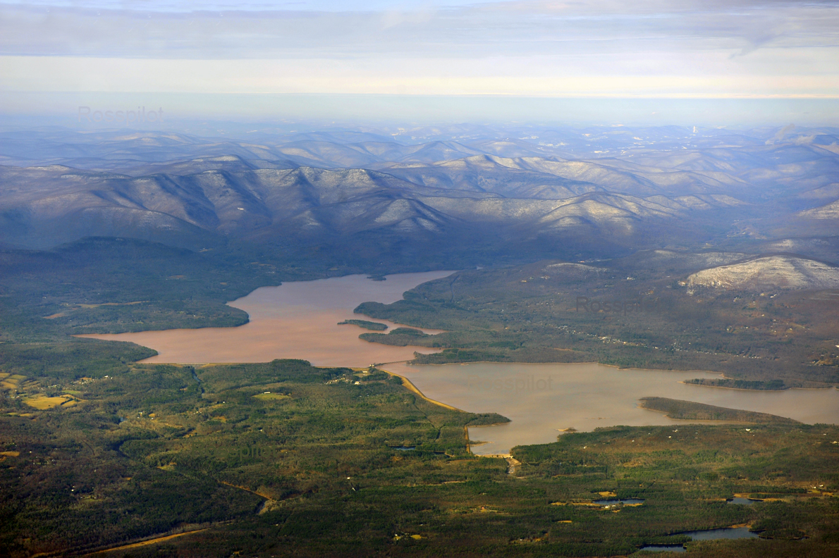
Ashokan Resrvoir as seen today

Ashokan Reservoir

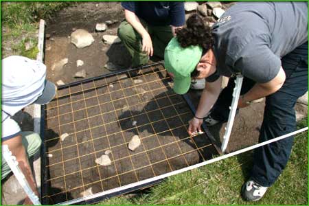
Ashokan Reservoir spans over 8,300 acres, previously farm land and towns.  New York City purchased the land through eminent domain in the early 1900s and eventually constructed a dam, creating the largest reservoir in the world at the time, upon the ruins of communities. An archaeologist begins with a hypothesis, and evaluates whether what they find fits what they expected to find. Our team, including Professor Dr. Beisaw, an archaeology major and three eager adventurous archaeology hopefuls did just that.


We wondered how this part of the Catskills was used before New York purchased it. What I found trekking through the forest with two archaeology students, who might or might not have mastered the GPS until the end of the day, helped us answer this question.
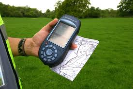
GPS and map we used to find our way through the Catskills.

GPS and map used 


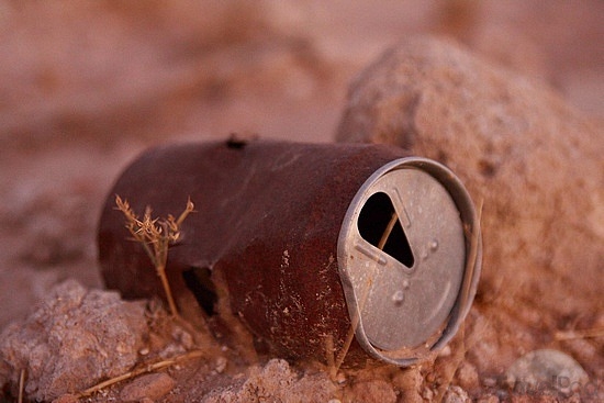
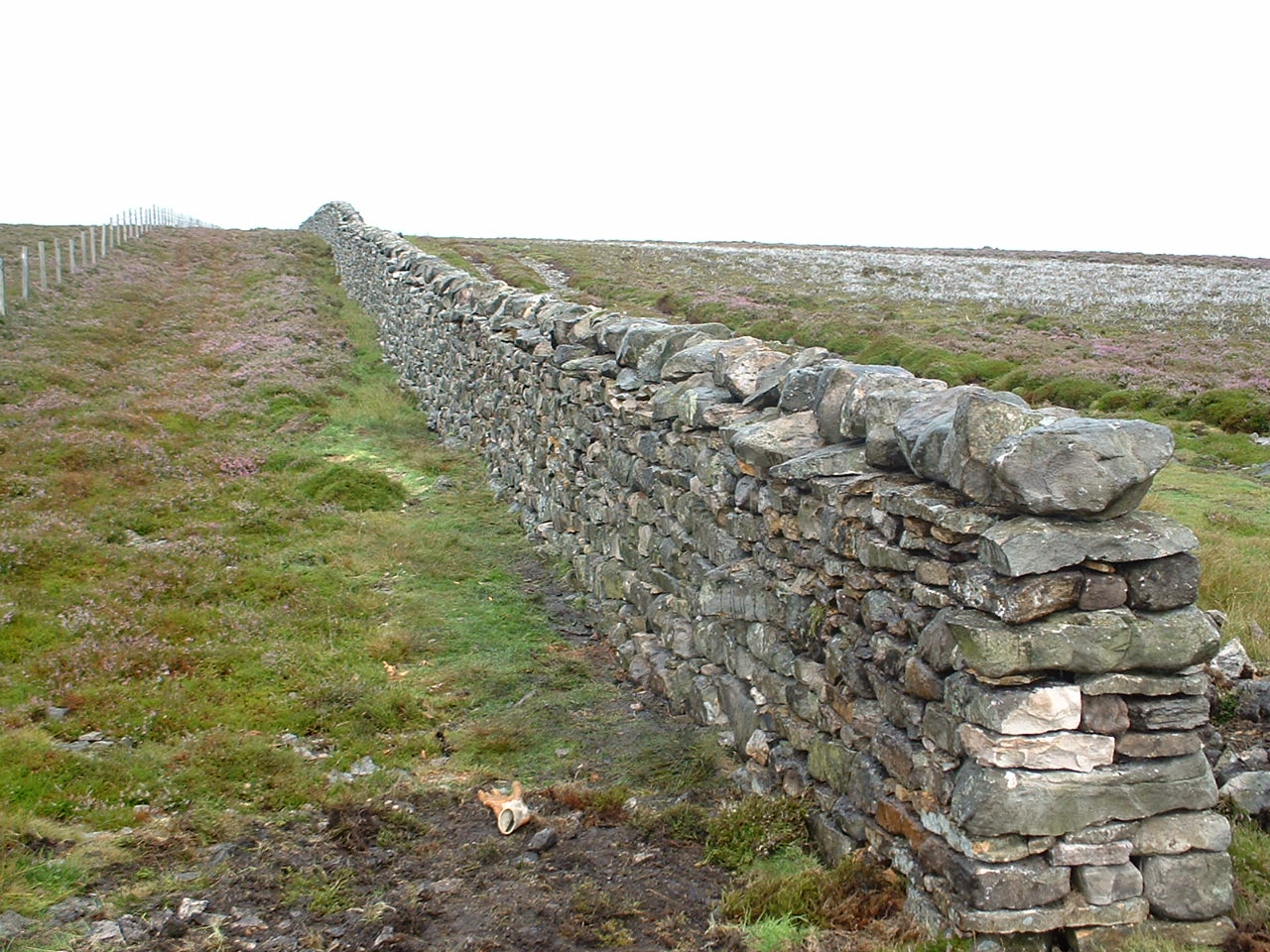
The first challenge is to not get lost. Having the right equipment is important (we did, thanks to our team leader), as is being able to use it! You also need to be sure that you’re not trespassing. Keeping everything in mind, we found a clearing with a big tree with branches close to the base. Forest trees don’t have branches near the base as light doesn’t reach here, so we deduced that this tree used to be in a pasture, which explained part of the past of this area. A bone, thought to be either pig or goat, suggested that people in the area had domesticated animals, although it is possible that the bone came from elsewhere, a transposed artifact. Stumbling across a road and finding rusty old cans and trash nearby with fewer items further up the mountainside suggested habitation in the lower area.  Clean, tool cut tree trunks indicated that people used the land there.  An important discovery was a stone wall, parts of which were deteriorating but others in prime condition; this suggested the land was marked for multiple purposes or animals.
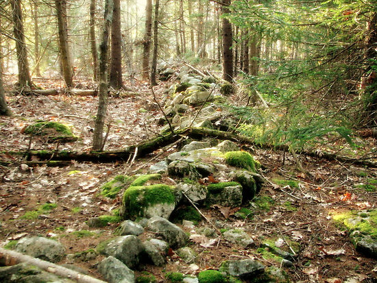
 

Similar stone wall we stumbled upon in the Catskills. With tress fallen upon it, moss and some deterioration.

Stone Wall

While all the finds (yes archaeologists consider a rusty old can, a pile of rocks and tree stumps finds and we had to stop and mark all of them on the GPS) answered some questions, they left some unanswered and raised others. Who knew how much one can learn from walking in the forest if you pay attention? Archaeologists do more than just dig. They learn about the past, answer questions, and more importantly, help plan for a better future.

Works Citied:

http://en.wikipedia.org/wiki/Ashokan_Reservoir

Image 1: http://www.skyviewpictures.com/skyviewstore/products.php?pid=258&detail=true

Image 2: http://www.flickr.com/photos/wessexarchaeology/176900281/

Image 3: http://www.cnyhiking.com/BestOfNCTinNY-BullyHillStateForest.htm

Do I really need the whip, or will the Fedora do?

Don the Fedora, holster your pistol, and coil your whip – it’s time for an archaeological expedition… or so I thought. Turns out, fieldwork doesn’t necessarily include dodging booby traps, stealing precious golden idols, or scurrying away from massive boulders.

Indy didn’t teach us much about real archaeology, did he?

To start off, there is a ton of preparation work that needed to be completed. Maps and charts had to be at the ready, plotting out the different paths and courses that the team had to take for the initial survey. Along with that, each team carried flags (to mark out artifacts), notebooks, a compass, measuring tape, a GPS device, a dSLR camera, a video recorder, walkie-talkies, and a rangefinder. Each member of the team was allotted a specific role, be it a navigator, recorder, photographer, or videographer.

I was placed in the team which did not have the aid of a mobile mapper, but only an old-fashioned map and compass (which was fine, because Indiana Jones managed alright without technology). Immediately, we had to get our bearings and figure out which direction we had to proceed. As we started to trek through the woods, we took pictures and studied the various artifacts we stumbled upon. Unlike the bones, treasure maps, and precious gems that I had pictured we would find, aerosol containers, beer cans, and old Coke bottles were strewn across the floor.

Surprisingly enough, a simple preliminary inspection of the artifacts revealed a lot more than I had expected. Just by looking at the design of the samples, it was possible to determine their age and purpose. For example, we came across an aerosol can which had been rusted and broken, with the label not visible anymore. It had a jagged plastic ridge that jutted out near the nozzle, which we inferred would be used for upholstery.

A rusted can gives so much information once you look deeper

A rusted can gives so much information once you look deeper

As we continued trekking along the winding hills, our team found manmade stone walls. Using the rangefinder and measuring tape, we calculated the length and height of it them, along with marking out any unusual rocks or discolorations along the walls. After taking numerous pictures and videos, we eventually moved on.

A dry stone wall similar to the ones we found

A dry stone wall similar to the ones we found

During our expedition, we lost touch with one of the teams. We decided to play it safe and launch a “search and rescue” style mission to seek them out. Even though all of us were confident that the other team was safe and it was just the topography of the hills that was interfering with communications, I was secretly hoping that they had been held captive by evil Nazis and I would have to use my whip-lashing abilities to rescue them. Fortunately, they were perfectly fine and we regrouped for lunch (unbeknownst to us, we had been eating for quite a while under a live wasp nest).

The drive back to campus provided a perfect opportunity to reflect on the day. Archaeology has been a passion of mine since I was six years old, and going on an expedition has been a dream of mine. I would never have expected my first experience to be something like this, but I can say with full confidence that it was a wonderful and eye-opening one. I found out that archaeology doesn’t have to do with bones, mummies, and coffins, but instead it has to do with what we can learn from the items that our predecessors have left behind. Something so small as a beer can to something as significant as a wall can give the same amount of information, but each tell a completely different story.


Sources:

How Stuff Works  -http://science.howstuffworks.com/environmental/earth/geology/archaeology2.htm

Image 1 – http://www.blakesnyder.com/wp-content/uploads/2012/09/raiders-of-the-lost-ark-imax.jpeg

Image 2 – http://images.travelpod.com/tw_slides/ta00/9c9/dea/rusted-can-buraidah.jpg

Image 3 – http://www.airedaleenterprise.org.uk/wp-content/uploads/2013/06/dry-stone-wall.jpg

Fieldwork: Not Your Average Dig.

When we were assigned field work as a part of archaeology class, my mind was immediately filled with images of excavations and lost artifacts. I could not have been more wrong; the only digging that occurred involved digging through the woods in order to get to the site.

We set out with one task in mind: to take a sampling unit at a previously found site in the Catskills. The Catskill Mountains are located in the Southeastern portion of the state of New York. They are home to a reservoir that supplies most of the water supply for New York City, located about 100 miles below. When New York City bought land from the Catskills to construct the reservoir, quarries were established to provide the necessary quantities of stone needed for its creation. While all of this was going on, many people were forced to leave their land. My archaeology professor, Dr. April Beisaw, is currently working on a project in the Catskills to determine how the lives of the people there were affected by all that was happening around them.

A Blue Stone Quarry located in the Catskill Mountains

A Blue Stone Quarry located in the Catskill Mountains

In order for us to get a taste of field work, Dr. Beisaw took us out in groups so that we could see some of what her project is all about. We drove to the Catskills, where we aimed to create a sampling unit at a site that had been previously discovered near a quarry. The goal of the sampling unit was to help us better understand what was going on at the places that had been surveyed. We found numerous types of broken glass containers, clam shells, metal fragments, metal cans, and broken dishes. Although at first these may seem like random objects, what they can tell us about the people that lived there is astounding.

An example of a grid sampling unit.

An example of a grid sampling unit.


If you did not know what to look for, it may seem irrelevant that there were multiple types of broken dishes, glasses, and glass containers. Everyone uses dishes, right? But when I think back to my home, I can distinctly remember having a set of matching dishes and glasses that we used on a regular basis. However, when you discover multiple dishes at one site, it begins to give you insight into the situation of the people that once lived there. Perhaps people often gave whoever lived there dishes or perhaps they could only afford mismatched items. Every find at a site can help an archaeologist learn a little more about what was really going on there.

Although people often only think of field work as excavations, there is so much more behind the term. Surveying and sampling can help an archaeologist get a better understanding of a site without ever having to break ground.  Field work can include excavation, but what we set out to do was a different type of field work. We set out with goal of gaining insight into the lives of those who had once lived in the Catskills.

Works Cited:

“About the Catskills.” The Catskills Homepage. Web. 2010. <http://www.thecatskillregion.com/about-the-catskills.aspx>

Ashmore, Wendy, and Robert J. Sharer. Discovering Our Past: A Brief Introduction to  Archaeology. Mountain View, CA: Mayfield Pub., 1988. Print.

Images:

http://catskillmountaineer.com/PWF-tremper.html

http://www.museumsofmayo.com/achill_1.htm

Further Reading:

http://www.catskillarchive.com/rrextra/DNAQUE.Html

http://www.utexas.edu/courses/denbow/labs/survey.htm

The Challenges and Joys of Archaeological Fieldwork

On Friday some of my fellow classmates and I went to do fieldwork for my Archaeology class with my professor. We surveyed the land and found some incredibly interesting things without even breaking the surface of the soil. It was a lot more work than I had initially thought. It made me think about those archaeologists who do fieldwork often. They are very dedicated because they have to deal with so many factors in the field. Fieldwork may not sound like a significant amount of work, but it truly is. Especially for the archaeologists who need to spend more than six hours in the field at a time. There are so many challenges to face when working in the field. In addition to mud, bugs, and weather conditions, there are also the unpredictable challenges that technical difficulties pose as well as navigation.

When people think of fieldwork, they imagine archaeologists digging for some sort of lost treasure or buried civilization. Pompeii is a good example of this. Pompeii was first excavated in 1748 after being preserved for over 2,000 years by lava from a volcano that erupted in 79A.D. Almost everything was preserved including buildings, skeletons, and even loaves of bread.

This picture depicts the excavation of Pompeii after the eruption of Vesuvius over 2,000 years prior.

This picture depicts the excavation of Pompeii after the eruption of Vesuvius over 2,000 years prior.

For more information about Pompeii and its excavation, see links below.

http://www.pompeiisites.org/Sezione.jsp?titolo=History+of+the+excavation+of+Pompeii&idSezione=1003

http://www.history.com/topics/pompeii

Although many archaeologists are still fascinated by Pompeii and other similar excavation sites, there are different types of archaeology that do not involve breaking through the surface of the earth. This includes underwater archaeology, which is incredibly difficult in the fieldwork aspect of it. Underwater archaeologists only have a finite amount of air in their tanks when they dive down to their site, at the bottom of the water.

A diver takes a look at the hull of the 1758 Land Tortoise, the oldest known warship of its kind. During this project, the underwater archaeologists had around 16 minutes for each dive so planning was essential.

A diver takes a look at the hull of the 1758 Land Tortoise, the oldest known warship of its kind. During this project, the underwater archaeologists had around 16 minutes for each dive so planning was essential.

Underwater archaeology is incredibly difficult and requires great consideration and planning; however, as my classmates and I learned on Friday, so does above ground archaeology. Surveying land does not seem like it needs particularly intense amounts of planning but it truly does. A major aspect of doing fieldwork (especially in the woods) is navigation. My group mostly worked with a compass and a map. We did our best to stay on our path but it was difficult because there were obstacles in the way. The terrain was very hilly and woody. There were some parts of the woods where we needed to go around large and tangled fallen trees and then reorient ourselves. It also takes a great deal of time when you are looking for artifacts and features. When you have an eye for finding these types of archaeological finds, there are usually many things that pop out at you- even a 1980’s beer can will tell you something about the people who used to inhabit that area.

In an age where we are all so interconnected through technology, it is difficult to imagine communication by walkie-talkie’s alone. That is what my classmates and I did on our fieldwork. We split up into three groups (with about three or four people in each) and split up the territory so that we could cover a greater amount of land. At least one person in each group had a walkie-talkie so that we could communicate with each other. However, when the land is hilly and the signal is not that powerful, problems could occur when attempting to contact another group. This happened for a brief period when we were about to eat lunch and we heard nothing from one of the groups. We then all went as a large group to look for our fellow classmates. We used our orientation skills to find their path and then finally were able to get in touch with them. This could also be a major area of stress and difficulty for archaeologists who have found something in the field and want a colleague to check it out.

Although there are many difficulties when doing archaeology fieldwork, it is truly worth it when searching and finding things about the people who lived there. Learning about a past culture helps us understand them better and therefore helps us better understand ourselves. If given the opportunity, I would highly recommend participating in archaeology fieldwork. Without digging a single hole in the ground, I learned so much about archaeological fieldwork and the people who used to live on the land that we were surveying.


Works Cited:

“History of the Excavation of Pompeii.” Pompeii Sites. N.p., n.d. Web. <http://www.pompeiisites.org/Sezione.jsp?titolo=History+of+the+excavation+of+Pompeii&idSezione=1003>.

“Pompeii.” History.com. A&E Television Networks, n.d. Web. 06 Oct. 2013. <http://www.history.com/topics/pompeii>.

Images:

http://www.billiesilvey.com/pompeii_excavation.jpg

http://www.dec.ny.gov/images/administration_images/0210boats5.jpg

No Shovels Required: What the Surface Can Tell Us About the Past

When you think about archaeology, what immediately comes to mind? I’ll take one guess: digging. It seems obvious, right? If you want to learn about the past, you have to look at old stuff, and if you want to look at old stuff, you have to dig it up. Excavation is the best possible way to uncover history, right?

Not necessarily. All it took was one short fieldwork expedition to show me that you can learn an incredible amount about a site’s past without ever putting a shovel in the ground. In fact, you can discover a whole lot by just walking around.

Let’s take, for example, an out-of-the-way spot in upstate New York called Acorn Hill. Located just a few minutes’ drive away from the Ashokan Reservoir in the Catskill Mountains, this inconspicuous site contains a wealth of archaeological information.

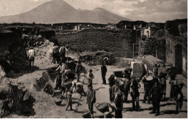
 The Ashokan Reservoir in upstate New York, where I did my fieldwork.

Although the entire area is now forest, a well-trained eye can tell that parts of it were once used as farmland. How, you might ask? Well, the most obvious clues are the stone walls. Even a short walk in the woods will reveal a number of stone walls snaking through the trees. Although these walls have crumbled and fallen over the years, they can still tell us a lot about the ways that the land was used. Some, for example, have been blackened by smoke and soot, suggesting that they were once part of a house that had a chimney.

Sometimes the very stones in the walls can provide information. If the stones are large and piled together somewhat haphazardly, they were probably pulled out of the ground when a nearby field was plowed. And if the ground on one side of the walls seems smooth, even, and less rocky, it was probably a crop field. A lack of large, old trees can also suggest where fields once were.

This photo illustrates this pretty well. See how the ground on the far side of the wall is lumpier, rockier, and has bigger trees, while the ground closest to the camera is flatter and has fewer rocks and smaller trees? That flatter ground was probably a field.

That brings me to another set of fascinating clues about a landscape’s past: trees! They might seem even less exciting than stone walls—after all, Acorn Hill is pretty much covered with trees, and they’re not even manmade—but they can tell us a whole lot about the ways that the land was used.

Aside from looking at the age of the trees, we can learn a lot from examining the types and shapes of trees that we pass. Non-native trees, such as apples and pears, suggest human influence, as do clean-cut stumps. Wide trees with lots of low branches indicate that the land was once used as a pasture. Farmers often left one or two trees in an otherwise clear-cut pasture so that the animals could get some shade. So because there weren’t lots of other trees blocking the sun, pasture trees could spread out and use their lower branches to soak in extra light that forest trees didn’t get.

A tree in a pasture vs. trees in a forest. Note the differences in shape and number of low-lying branches.

So the next time you go for a walk in the woods, take a look at the ground underfoot and the trees overhead. You might be amazed by what you discover.

Citations:

Image 1: http://www.northeastcycling.com/catskills_tour_files/ashokan_res_L.JPG

Image 2: http://rockpiles.blogspot.com/search?updated-max=2009-11-05T06:17:00-05:00&max-results=20&start=20&by-date=false

Image 3: http://imgc.allpostersimages.com/images/P-473-488-90/61/6157/HPXG100Z/posters/frank-lukasseck-lime-tree-and-dandelion-in-pasture.jpg

Image 4: http://www.wallsave.com/wallpapers/1209×806/sunset-trees/416669/sunset-trees-forest-all-wonderfull-416669.jpg