As conveyed by its name, the Great Dismal Swamp in southeastern Virginia is an inhospitable place. Throughout the region’s colonization, the swamp was considered a “twisted and dark natural landscape” to be avoided whenever possible (Sayers 2014:82). These features helped establish it as a place of migration for runaway slaves, historically known as “Maroons.” The security provided by the swamp’s isolation allowed them to create self-organized communities that spanned generations. With only passing mentions in the historical narrative of slavery and liberation, the Great Dismal Swamp was primarily thought of as a temporary stop on the Underground Railroad (Grant). Despite these misconceptions, recent archaeological research has contributed a better understanding of how the insular communities thrived outside of the existing slave-based economy.
The Great Dismal Swamp was known to the Algonquin people for thousands of years. After their displacement during Virginia’s colonization, scattered bands of Native Americans resettled in the marshes. Shortly after the introduction of slavery in 1619, runaway slaves migrated to the swamp in search of safety. Their presence predominates the archaeological record of the swamp between 1680 and the Civil War (Grant). Later on, colonists began to extract the swamp’s natural resources through logging and canal digging, including a project undertaken by George Washington (Figure 1). Their commercial efforts likely had the effect of pushing the communities further into the swamp.

Figure 1: A marker indicating the site of George Washington’s Canal Project. Photograph by Allison Shelley.
Efforts to excavate the Great Dismal Swamp are led by Daniel Sayers, a professor at American University. Beginning in 2003, the Great Dismal Swamp Landscape Study has identified eight archaeological sites of interest. Most of Sayers’ research focuses on the “nameless site,” a 20-acre island located two miles in the swamp’s interior (Sayers 2014:25). Evidence recovered from the site includes the foundations of seven cabins and several thousand artifacts, suggesting that it was used as a permanent settlement. Interestingly, Sayers has identified a material culture practiced by the communities. Due to their isolation from the outside world, inhabitants used debitage to continuously repurpose stone tools left behind by Native Americans (Figure 2) (Grant).
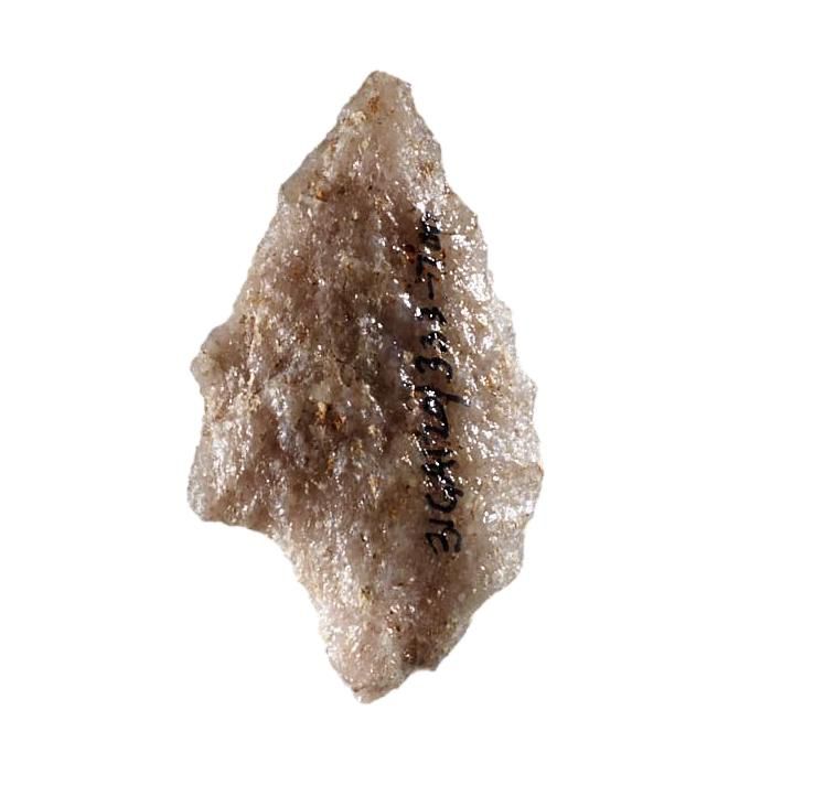
Figure 2: An example of a repurposed arrowhead. Photograph by Jason Pietra.
Researching the Dismal Swamp communities presents a unique set of challenges, mainly due to the nature of the swamp. The very conditions that discouraged outsiders from traveling into the swamp’s interior have slowed excavations. Sayers’ team must contend with the heat, mud, insects, and thick vegetation associated with the region. Furthermore, because of their material culture, most of the recovered artifacts are incredibly small. According to Sayers, “Everything we’ve found would fit into a single shoe box… they were using organic materials from the swamp. Except for the big stuff like cabins, it decomposes without leaving a trace” (Grant).
The significance of the Great Dismal Swamp research project cannot be understated. By focusing on the swamp, it restores the history of a forgotten community that fleed racial tyranny and seized control of their destiny.
References Cited
Grant, Richard
2016 Deep in the Swamps, Archaeologists Are Finding How Fugitive Slaves Kept Their Freedom. Electronic Document, https://www.smithsonianmag.com/history/deep-swamps-archaeologists-fugitive-slaves-kept-freedom-180960122/, accessed November 23, 2019.
Sayers, Daniel O.
2014 A Desolate Place for a Defiant People: The Archaeology of Maroons, Indigenous Americans, and Enslaved Laborers in the Great Dismal Swamp. University Press of Florida, Gainesville, Florida.
Images
Grant, Richard
2016 Deep in the Swamps, Archaeologists Are Finding How Fugitive Slaves Kept Their Freedom. Electronic Document, https://www.smithsonianmag.com/history/deep-swamps-archaeologists-fugitive-slaves-kept-freedom-180960122/, accessed November 23, 2019.
Further Reading
To listen to a podcast episode about the Great Dismal Swamp communities:
To learn more about the history of the Underground Railroad:
https://www.nps.gov/subjects/ugrr/discover_history/index.htm