
Traditional methods of archaeology include on-ground exploration and using historical maps and records. Many of these methods have been replaced by or are now practiced in conjunction with newer technologies, such as LiDAR. LiDAR, which stands for Light Detection and Ranging, is a “remote sensing method that uses light in the form of a pulsed laser to measure ranges (variable distances) to the Earth. These light pulses—combined with other data recorded by the airborne system— generate precise, three-dimensional information about the shape of the Earth and its surface characteristics” (NOAA 2012). The most common platforms used for LiDAR surveys are helicopters and airplanes, and the LiDAR equipment is, in basic form, a laser, scanner, and GPS receiver (NOAA 2012). The data received by the LiDAR instrument measures the time it takes for the light pulses to return to the aircraft (Renfrew 2015). This information is then translated into an aerial map of landscapes archaeological features such as man-made structures.
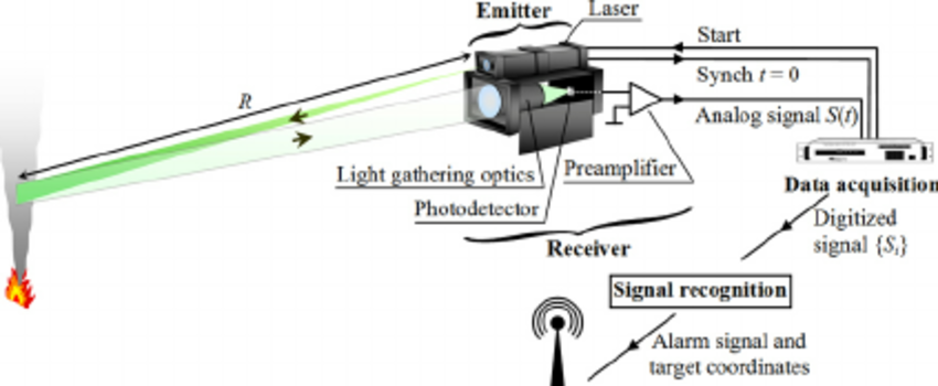
“Lidar equipment and detection principles.”(https://www.researchgate.net/profile/Andrei_Utkin/publication/221616433/figure/fig1/AS:305682927636484@1449891897394/Lidar-equipment-and-detection-principles.png)
This LiDAR technology has been incredibly valuable within the field of archaeology because it is able to map and record things that humans are incapable of on foot. For example, studying rainforest sites is extremely difficult due to the extreme terrain and abundant wildlife, especially the expansive rainforest canopies. Because of this limited access to these sites, some of the histories of these areas is largely unknown. This leads to many legends and even articles to be written about these “lost civilizations” that have been “discovered.”
One study by the University of Central Florida, for example, used LiDAR to recover ancient Mayan cities at Caracol in Belize. Before this technology, archaeologists were mostly unable to analyze the innovative accomplishments and ingenuity of the Maya because of the dense and difficult to navigate rainforests. One interesting question that was raised in this study is as follows:
“It often appears that sites in more easily studied areas of the world–plains, sparse forests, or areas cleared in modern times—are larger and more complex than their tropical forest counterparts. Does this impression reflect the inability of ancient humans to create large, sustainable settlements in the tropics, or is it the result of incomplete investigations, hampered by the complications of working in a rainforest?”(Chase 2010).
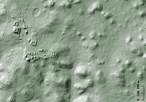
“In this LiDAR image of the Caracol epicenter, the jungle cover has been removed. Clearly visible—as ripples in the valleys and hillsides—are the agricultural terraces the ancient Maya constructed to feed the sprawling city.” (Courtesy Arlen Chase) (https://archive.archaeology.org/1007/etc/caracol.html)
The LiDAR system can read through the thick forest canopies, revealing the features underneath, allowing archaeologists to analyze these structures and to identify potential activity areas that might warrant further excavation. This study was able to confirm that Caracol was a “low-density agricultural city encompassing some 70 square miles” (Chase 2010). The researchers’ previous data, documented through ground field work had recorded some features, but the LiDAR assisted them in documenting the site’s “entire communication and transportation infrastructure at its height during the Late Classic Period” (Chase 2010). Other sites where LiDAR has been exponentially valuable are those at Tikal in Guatemala and Calakmul in Mexico. LiDAR, however, does have a few drawbacks. It cannot record completely perishable structures and although it can distinguish features that are less than a foot in height, it is still not completely accurate and will always require further research and groundwork. The benefits of LiDAR, however, are invaluable in excavating archaeological sites and in allowing archaeologists to reconstruct ancient civilizations.
Additional Content:
Clynes, Tom. “Laser Scans Reveal Maya ‘Megalopolis’ Below Guatemalan Jungle.” National Geographic, National Geographic Society, 14 Feb. 2018, news.nationalgeographic.com/2018/02/maya-laser-lidar-guatemala-pacunam/.
Loughran, Jack. “Lidar Used to Make 3D Model of the Amazon to Understand Drought Impact.” RSS, The Institution of Engineering and Technology, 13 June 2018, eandt.theiet.org/content/articles/2018/06/lidar-used-to-make-3d-model-of-the-amazon-to-understand-drought-impact/.
References:
Chase, Arlen F., et al. “Archaeology Magazine – Lasers in the Jungle – Archaeology Magazine Archive.” Who Were the Hopewell? – Archaeology Magazine Archive, Archaeological Institute of America, 2010, archive.archaeology.org/1007/etc/caracol.html.
NOAA. “What Is LIDAR.” NOAA’s National Ocean Service, Department of Commerce, 1 Oct. 2012, oceanservice.noaa.gov/facts/lidar.html.
Renfrew, Colin, and Paul G. Bahn. Archaeology Essentials: Theories, Methods, Practice. 2nd ed., Thames & Hudson, 2015.
LiDAR is really cool technology! Interesting to read a detailed report of how it works and some downsides to using the technology. LiDAR looks at large scale objects obscured by landscapes. LiDAR was not made by archaeologists for archaeology like most technology archaeologists use, but we use it happily! I wanted to ask what you think this technology would look like if it were made for archaeology. What type of things would it be able to see? Do you think if the technology were made specifically for archaeology, it would be able to see smaller scale items? It’s essentially lasers and radars, and I’m no expert in either, but what would the technology look like if it were archaeology-centered.