Kuturbulak
December 7, 2017
Alternative Spelling: Kutur-Bulak, Kutur Bulak (Russian: Кутурбулак).
GPS Coordinates: 39°53’5’’N 66°2’55’’E (Szymczak & Gretchkina, 2000).
The following measurements were taken using Google Earth.
Elevation: 518 meters
Distance to Kattakurgan (nearest town): 19.2 km
Distance to the Samarkand city: 82.1 km
Geography and Borders
Kuturbulak is an archaeological Middle Paleolithic open-air site situated near the modern day village kishlak in the Samarkand Region of south-eastern Uzbekistan. Located south of Karadaria river that flows northwest (a tributary of the Syr Darya), the site lies in the southernmost part of the densely populated Zeravshan River valley and on the northern foothills of Utch-airy mountain where waters flow into gorges meridionally leading to formation of springs. About 19.2 km to the east of Kuturbulak situated a large town Kattakurgan. The Samarkand city, capital of the region, is situated about 80 km southeast of the site. Moreover, Zirabulak, another Middle/Upper Paleolithic site, lies about 1 km to the West of Kuturbulak (Tashkenbaev, 1975; Szymczak & Gretchkina, 2000).

Fig 1. General location of Kuturbulak (KB, annotated by the black triangle), the open-air Middle Paleolithic site in Zeravshan River valley (figure from Szymczak & Gretchkina, 2000, drawn by D. Baginska, after T. Madeyska)
Archaeology
Kuturbulak site is abundant in archaeological materials, many of which were preserved intact in the duricrust fossil layer. Two major archaeology expeditions were conducted, providing a comprehensive analysis on the Kuturbulak’s geometrical structures, stone artifacts and faunal remains. N. Kh. Tashkenbaev and R. Kh. Suleimanov first excavated the site during field seasons of 1971 and 1972. Then in 1996, archaeologists from Warsaw University and Uzbek Academy of Sciences in Samarkand, in collaboration, enlarged the excavation area and published a monograph which includes the first record of absolute dating of the site (Szymczak & Gretchkina, 2000).
Stratigraphy and Absolute Dating
The stratigraphy of the trench walls showed five distinct layers with Middle Paleolithic materials corresponding to different cultural phases, according to the interpretation of Tashkenbaev and Suleimanov. Numerous stone artifacts were found in layer I and III to V; animal bones and dark burning spots interpreted as the use of hearth were discovered in layer III. However, analysis by visiting geologists and the archaeology excavations in 1995 agreed that layer I to IV with secondary materials were disturbed and represented cultures much later than Middle Paleolithic, and only the artifacts in layer V had their original provenance. The number of cultural layers and their implications could not thus be ascertained. The hearths examined in a wider context were re-interpreted as historical ones rather than belonging to the Middle Paleolithic settlement. U/Th method dated a poorly preserved bone 85-90cm below the surface to 32.91.1 ka, while the result wasn’t reproduced and the sample might subject to geochemical processes (Szymczak & Gretchkina, 2000).
Stone Artifacts
The lithic artifacts recovered in the 1970s reached 7800 pieces, mostly made of quartz or river quartzite pebbles of different colors. Only a small percent of the assemblage was made of various flints, although natural flint materials were found in continuous layers among limestones near the site and were easily obtainable. During 1995 field season, researchers recovered 1114 stone artifacts from the trench. Due to strong evidence of secondary disturbances of the stratified layers (such as intense human activity), they divided the layers into the upper disturbed layers and lower undisturbed layers. However, even the lower layers might subject to duricrust activity caused by the variations in spring outflow. The stone artifacts were classified into flakes (with irregular retouch traces), flake cores (multiangular or of one-sided discordal shape), blades (with irregular or well-marked retouch), and other retouched tools (side-scrapers, points, end-scrapers, etc.). Only two backed knives, a characteristic type of tools of Middle Paleolithic settlement, were found in the disturbed layers. The proportion of retouched tools was remarkably high, around 41.3% in the upper layer and around 39.0% in the lower layer, while the researchers pointed out the possibility of psuedoretouching of the stone materials caused by temperature, humidity change or carbonate crystallization, as evidenced by the irregular and discontinuous traces of retouch on some of the tools. Nevertheless, a great number of retouched tools showed evidence of intense resharpening, including some heavily reduced cores and some very small flakes without any clearly defined shape. The intense and economic use of materials that produced delicate small tools, along with Kuturbulak’s location (near the mountain with abundant water resources, such as the Kuturbulak spring), indicated long-term inhabitation of the area (Vishnyatsky, 1999; Dani & Masson, 1992). Moreover, produced by lithic reduction (a dominant technology in Upper Paleolithic epoch), blade and blade tools accounted for a high proportion of the lithics inventory (16.9%). Three complete burin blades, another Upper Paleolithic characteristic tool type, were found in Kuturbulak, two of which were slim and of distinct angled form (Szymczak & Gretchkina, 2000).
Some researchers categorize the technology of Kuturbulak as the Levallois-Mousterian variant due to the great proportion of Levalloisian flake stone tools (Krakhmal, 2005), and the distinct quartzite products reflect the raw material availability in Kuturbulak rich in river pebbles (Vishnyatsky, 1999). The Mousterian culture with flake tools is usually associated with Middle Paleolithic, the epoch that marks the rise and extinction of Neanderthals who were then replaced by modern humans during the late stage. According to an unauthorized Russian website, Neanderthals who inhabited Kuturbulak were the most ancient population discovered in the Samarkand region (Mikhailovich, n.d.). On the other hand, the unbelievably high abundance of retouched tools shows a technological continuity or directional shift of lithic reduction techniques, marking a significant local evolution, the Middle Paleolithic/ Upper Paleolithic transition (Szymczak & Gretchkina, 2000; Biagi, 2008; Soffer, 2014).

Fig 2. Some stone artifacts found in Kuturbulak. Tools (1-7, 9-12, 15, 17) and cores (8,13,14,16). (Tashkenbaev & Suleimanov, 1980)
Faunal Remains
The animal bones were poorly preserved in situ and those recovered were in the form of small fragments, so only a general description of the identified faunal remains was provided. Horse (Equus caballus) was the most dominant species and accounted for almost a half of the identified bones (49.3%). Ox (Bison), wild ass, deer and elephant remains were also identified during the excavations in 1970s. The researchers then argued that remains of elephant in layer III, a species indicative of middle Pleistocene epoch in Central Asia, showed evidence that the stone artifacts were preserved in their primary provenance in the undisturbed layer. Indeed, assemblages of large mammals from various sites in Eurasia show wide distribution of elephants and even some evidence of butchering activities by human in middle Pleistocene (Pushkina, 2007; Anzidei et al., 2012). Based on the assumption that the assemblages were all in their primary position, these researchers further conjectured that the prehistoric landscape was an arid steppe land. However, the expedition team in 1995 only recovered horse remains, including a mandible fragment and some teeth, in the undisturbed layer V. Nonetheless, some researchers concluded that the prehistoric inhabitants of Kuturbulak were Neanderthals chasing after dangerous herbivores including horses and elephants (Szymczak & Gretchkina, 2000).
Conclusion
Kuturbulak is an important open-air site in the Zeravshan river valley region, in that the tool types, including Mousterian flake tools and blade flake tools, mark a technological continuity from Middle to Upper Paleolithic, and an unusually high proportion of small, heavily reduced cores shows long term inhabitation of the area, possibly by Neanderthals.
Bibliography
Anzidei, A. P., Bulgarelli, G. M., Catalano, P., Cerilli, E., Gallotti, R., Lemorini, C., . . . Santucci, E. (2012). Ongoing research at the late Middle Pleistocene site of La Polledrara di Cecanibbio (central Italy), with emphasis on human–elephant relationships. Quaternary International,255, 171-187.
Biagi, P. (2008). The Palaeolithic settlement of Sindh (Pakistan): A review. Archäologische Mitteilungen Aus Iran Und Turan, 40. 1-26.
Dani, A. & Masson, V. (1992). History of Civilizations in Central Asia. Vol. I: The Dawn of Civilization: Earliest Times to 700 BC (A. Dani, Ed.). Paris: UNESCO Publishing.
Krakhmal, K. (2005). On Studying of Historical and Cultural Processes of the Palaeolithic Epoch in Central Asia. International Journal of Central Asian Studies, 10, 119-129.
Mikhailovich, R. O. (n.d.). List of sites of primitive man. Retrieved from http://arheolog.su/kamen_vek/stoyanki/
Soffer, O. (2014). Pleistocene old world: regional perspectives. New York: Springer.
Szymczak, K., & Gretchkina, T. (2000). Kuturbulak revisited: a Middle Palaeolithic site in Zeravshan River Valley, Uzbekistan. Warsaw: Institute of Archaeology, Warsaw University.
Tashkenbaev, N. Kh. (1975). Ob issledovanii paleoliticheskoi stoyanki Kuturbulak (On the investigation of the Paleolithic site of Kuturbulak). Istoria materialnoi kultury Uzbekistana, 12, 5-15.
Tashkenbaev, N. Kh., and Suleimanov, R. Kh. (1980). Kultura drevnekamennogo veka doliny Zeravshana (The Old Stone Age Culture of the Zeravshan Valley), Tashkent.
Pushkina, D. (2007). The Pleistocene easternmost distribution in Eurasia of the species associated with the Eemian Palaeoloxodon antiquus assemblage. Mammal Review, 37(3), 224-245.
Vishnyatsky, L. (1999). The Paleolithic of Central Asia. Journal of World Prehistory, 13(1), 69-121.
Samarkandskaya
December 7, 2017
Also known as: Самаркандская Стоянка (Russian for ‘Site of Samarkand’)
Coordinates: c.39.65° N, 66.94° E (Rabett, 2012)
Image 1. Showing approximate coordinate location of Samarkandskaya from Rabett (2012) at an elevation of 24.05 km. Coordinates put site in center of city, not near a ravine as described by Vishnayasky (2004). There is a river 6 km southwest (measured on Google Earth) which could possibly be the Chashmasiab ravine; however, the exact location of the site could not be found.
Samarkandskaya is an open air Paleolithic site within the limits of Samarkand, a city in eastern Uzbekistan, close to the Tajikistan border (Image 2). The city is located in the Zeravshan basin, a fertile area created by mountain runoff and the Zeravshan river. The site itself is located in the center of the city, on the right bank of the Chashmasiab ravine (Image 1).

Image 2. Map of Central Asia showing location of Samarkand site and other relevant paleolithic sites (Davis & Ravnov 1999).
Cultural remains are confined to deposits in two terraces, originally thought to make up three cultural layers (Vishnayatsky, 2004). From its discovery in 1939 by N. G Kharlamov, Samarkandskaya was a site of intensive study by multiple successive researchers until the 1970s. It was M.V Voevodskyi who initially lead the research on the site. The next excavations were done by D.N Lev in 1958 and 1967, which revealed the multilayered nature and numerous peculiarities of the materials. The next excavations from 1967-72 were done by M.D Djurakulov and E.N Amartzeva who focused mainly on the lower sediments of the upper terrace (Korobkova & Djurakulov, 2000). A total area of 1000m2 has been excavated and no new excavations are taking place.
The cultural layers of the site are complicated by the extremely complex stratigraphy of the site, poor excavations, and inadequate documentation. In 1980, Nesmeyanov used geological investigations of the site to argue against Lev’s hypothesis of the site containing three unique cultural layers. The layers instead may represent periods of intensive occupation that are marked by deposits of tools, bones, charcoal and ocher (Vishnayatsky, 2004). Nesmeyanov identified four layers of habitation in the lower terrace and three in the upper terrace. This has also complicated the dating of the site.
The occupational episodes are thought to have occurred between the Middle to the late, final Pleistocene. Earlier excavators and researchers, such as Lev, dated the site to 20,000 b.p (methods of dating are not published/accessible); however, the work by Nesmeyanov and closer examination of the upper terrace by Korobkova, Djurakulov, and Amartzeva resulted in a date of 40,000 b.p. Presumably the date was obtained from examination of the materials found. The oldest lithic materials were from the lower level of the upper terraces which is now thought to represent the first habitation of the site. Davis & Ranov (1999), Korobkova & Djurakulov (2000), and Derevyanko & Zun (1993) all decisively place Samarkandskaya in the Upper Paleolithic. This makes Samarkandskaya one of the few Upper Paleolithic sites in the region. The other well known site is Shugnou in eastern Tajikistan (Fig. 1). Vishnayatsky (2004) mentions the finding of charcoal at the site; however, it is unclear if carbon-14 dating has been done to date the site. These dates are mainly based on the lithic composition and its similarity to other sites such as Kulbulak and layer 2 of Karasu.

Fig.1 Chart summarizing the relative dating of Samarkandskaya and other paleolithic sites in the region. The left-hand column represents hypothesized dates while the right hand column is the majority of absolute dates known for Central Asia (Davis & Ranov, 1999).
There is nothing published on the complete composition, numbers, or distribution of stone tools at Samarkandskaya, but from what is reported the tools show a mixture of Mousterian with Upper Paleolithic technologies. Pebble-chopper technology is present with tools such as choppers, side-scrapers, axes, discoid and Levellois type cores (Fig.2). This is mixed with artifacts attributed to the Upper Paleolithic such as retouched bladelets, chisel-like tools, micro-scrapers, and microcores (Fig 3).

Fig. 2. Chopper tools and flakes from Samarkandskaya (Korobkova & Djurakulov, 2000).

Fig. 3. Stone tools demonstrating some the Upper Paleolithic technologies used at the site (Vishnayatsky, 2004)
Samarkandskaya is not the only site in this area or from this time that shows mixed tool technologies, such as Maikop or Shugnou. Although each site has a unique lithic composition, some have used the similarities to make possible cultural and developmental connections between Paleolithic sites in Central Asia. Derevyanko & Zun (1993) describe what they call the Samarkand culture, which in theory, is a step in the line of evolution influenced by the Asia Minor ‘Mediterranean’ province. In this line of evolution, the cultural development started with the site of Karasu, then to the Samarkand culture, and ended with the post-Palaeolithic Hissar culture. This hypothesis is based on qualitative similarities between the tools, such as the knife shape and hollow tools. This hypothesis was strongly supported by Lev; however, little to no concrete evidence is available to support this (Derevyanko & Zun, 1993).
Excavations in 1962 and 1966 resulted in the findings of the only human remains at the site; two fragmented mandibles and teeth. These are attributed to modern Homo sapiens, but there provenance is unknown. Their affiliation with the rest of the paleolithic assemblage has also been questioned. The mandibles have been described as being of ‘Mediterranean-type,’ supporting the Asian Minor line of evolution. More recent descriptions of the remains are not available and may contradict this description (Derevyanko & Zun, 1993). Aside from human bones, there are more than 3,000 identifiable bones and bone fragments. The majority of the remains are from horses followed by pleistocene ass and aurochs. Also present are remains of camel, red deer, wild boar, steppe sheep, gazelle, wolf and wild ass but in lesser quantities. There are also long bone fragments that most likely correspond to an elephant or rhinoceros (Vishnayatsky 2004).
The vast number of animal bones and the high percentage of tools suggests that Samarkandskaya was a base camp for steppe/desert hunters, who mainly hunted wild horse and Pleistocene ass. There is evidence of almost constant tool production and retouching, as well as evidence of preparing carcasses and skins from kills (Korobkova & Djurakulov, 2000). The culture and chronology of the site have not been determined, but traditionally the archaeological assemblage has been treated as belonging to the same culture. However, this may be incorrect considering there were likely multiple episodes of habitation that occurred widely spaced in time (over tens of thousands of years). More analysis of the tools found and of the geography of the site is still needed for any conclusions on the dates of the site and the culture or cultures that were present.
Works cited
Davis, R. S., & Ranov, V. A. (1999). Recent work on the Paleolithic of Central Asia. Evolutionary Anthropology: Issues, News, and Reviews, 8(5), 186-193.
Derevyanko, A. P., & Zun-E, L. (1993). Upper Paleolithic Culutre. In History of Civilizations of Central Asia(Vol. 1, pp. 89-98). UNESCO.
Korobkova & Djurakulov. (2000). самркандская стоянка как эталон ерхнего палеолита средней азии (The Site of Samarkand as a Model of the Upper Palaeolithic in Central Asia). Stratum plus,1, 385-462.
Rabett, R. J. (2012). Human adaptation in the Asian palaeolithic: hominin dispersal and behaviour during the Late Quaternary. Cambridge: Cambridge University Press. pp 92-95.
Vishnayatsky, L. B. (2004). Paleolithic Interface in Central Asia. In The Early Upper Paleolithic Beyond Western Europe (pp. 151-159). CA: University of California Press.
Parkhai II
December 7, 2017
Coordinates
38°26’10.2″N 56°17’01.1″E (Coordinates of Kara Kala) Site is very difficult to locate on map. No coordinates nor metrics of distance from Kara Kala are reported by Khlopin.
Elevation
310m (Kara Kala)
Alternate Spellings
Parkhay II, Parhai II, Parhay II
Introduction and Geographical Description
Parkhai II is an Early Bronze Age cemetery, located along the northern edge of the Sumbar Valley in Southern Turkmenistan on the southwestern outskirts of the modern town Kara Kala (Kara Q’ala) (Khlopin 1981; Hiebert et al., 2003). The Sumbar Valley is in the westernmost area of Kopet Dag foothill region (Arkhash Region) (Hiebert, 2002). It is a minor tributary valley, which promotes the existence of vegetation in the region (Gubaev et al., 1998). Surrounded by the Kopet Dag Mountains, this area is an oasis. It is protected from the cold air from the North and the extremely dry air from the Kara Kum Desert to the East (Brummell, 2005). Parkhai II is part of a larger settlement, Parkhai-tepe, which is located 300-400m south of the graveyard (Khlopin 1981; Petrie, 2013). The main settlement has yet to be excavated (Petrie, 2013). The site is located on a hill 10m above the valley floor on a mound on the northern bank of the Sumbar River (Khlopin 1981; Hiebert, 2002). There are few alluvial deposits at the site since it is located on a hill, making the cemetery easily accessible for excavation (Hiebert et al., 2003).
Parkhai II is indirectly dated the the Early Bronze age. Excavations of the site connect Parkhai to Early and Late Bronze Age sites in the Kopet Dag foothills of Southern Turkmenistan. These Kopet Dag sites were often sedentary farming societies. Additionally, it has striking bronze objects and pottery. More extensive study of this site would aid in dating and a better understanding of what people were doing at Parkhai II.
Excavations
I.N. Khlopin and members of the Sumbar Archaeological Expedition of Leningrad Sector of the Institute of Archaeology (USSR Academy of Sciences) discovered the site in 1977 (Khlopin, 1981). The first full excavation took place in 1978. The team excavated 27 burials, 300 ceramic vessels, and various stone and bronze artifacts. It seems that the excavation by Khlopin in 1978 was the last excavation of the site since little further published information exists (Petrie, 2013).
Date
The site is indirectly dated to the Late Copper Age or Early Bronze Age in the first half to the middle of the 3rd millennium B.C. (Khlopin, 1981; Hiebert, 2002). The site has been difficult to date and no direct date has been reported. Researchers found evidence that points to two time ranges, resulting in an expansive time range (3000-2250 B.C.) for Parkhai II. This is a result of the indirect dating techniques. Initially, the site was dated closer to 3000-2500 B.C. This date was inferred by pottery found at sites in the northern foothills of the Kopet Dag, Kara-depe and Ak-depe, which seems to be imported from Parkhai II (Khlopin, 1981). Kara-depe and Ak-depe are Early Bronze Age sites (3000-2500 B.C.), placing Parkhai II in this time period (Khlopin, 1981). Khlopin provides additional evidence to date Parkhai to 3000-2500 B.C. by noting that ceremonial rites at Parkhai II are similar to those at Kara-depe, especially in the positioning of bodies (Khlopin, 1981). Finally, Khlopin dates Parkhai to the middle of the 3rd millennium B.C. (2500-2250 B.C.). Khlopin associates a lapis lazuli awl (tools used for making holes) found at Parkhai II with awls at Tureng-tepe and Ur (1981). Tureng-tepe and Ur date to the middle of the 3rd millennium, broadening the time range for Parkhai to 3000-2250 B.C (Khlopin, 1981). A direct date for this site is needed to confirm the Parkhai II date.
Finds
Parkhai II is a cemetery consisting of 450 burials; 27 burial vaults were excavated, revealing human remains, 300 vessels, and various stone and bronze objects (Khlopin, 1981). It is associated with the broad cultural area (cultural sphere) of southwestern Turkmenistan during the Early Bronze age based on burial characteristics, spiral headed pins, and pottery. Specifically, Parkhai II is linked to Kopet Dag 6 (sites: Anau II, Late Namazga II, Namazga III), which were settled farming sites (Hiebert, 2002). It is possible that like the people in the Kopet Dag 6 sphere, people at Parkhai II were settled farmers. However, there is no direct evidence to support farming. It is also associated with Late Bronze Age sites in the Sumbar Valley (southwestern Turkmenistan) due to burial characteristics and pottery.

Figure 1. Burial chamber construction (Khlopin, 1981).
The burial chambers were usually 0.9-2.0m below the contemporary surface and were reached by through a side entrance covered by a stone slab (Khlopin, 1981; Dani & Masson, 1999) (Figure 1). They were round, collective tombs with multiple burials (Petrie, 2013). Tombs were often collective burials (Khlopin, 1981) For example, Chamber 24 (Figure 2) had a woman (23-25 years old) buried with two pottery vessels and a bronze pin, a child (8-9 years old) buried with bronze earrings and a steppe tortoise shell, and two infants buried without grave goods (1981). Additionally, chambers were used for subsequent burials; bones of the first burial were pushed deeper into the chamber and the newer burial took their place (Khlopin, 1981). It is unclear how Khlopin came to this conclusion, but it may have been based on stratigraphy. The collective tombs with multiple burials are similar to those at Ilgynly-depe, uniting them under a similar cultural sphere in southern Turkmenistan during the Early Bronze Age (Petrie, 2013). Interestingly, the burials do not seem to emphasize wealth or status (Petrie, 2013). They are unique because they are completely separate from the residential part of the settlement (Petrie, 2013). This separation of burial and residential areas groups Parkhai II culturally with Late Bronze Age burials in the valley region of Southern Turkmenistan (Parkhai I, Sumbar I, Sumbar II, Yangi Q’ala) (Petrie, 2013).

Figure 2. Burial Chamber 24. Woman with child and two infants. (Khlopin, 1981)
Additionally, bronze six spiral double-headed pins were among some of the most striking finds at the burial (Khlopin, 1981, Dani & Masson, 1996). The pins (Figure 3) all had more than four loops (Khlopin, 1981). The Parkhai II pins are distributed all over the Sumbar Valley in Southwestern Turkmenistan, once again uniting this cultural area (Khlopin, 1981). According to Hiebert (2002), these bi-spiral pins help associate Parkhai II with Kopet Dag 6 cultural region. The Kopet Dag 6 cultural region, in the foothills of the Kopet Dag mountains, had farming settlements (Hiebert, 2002). These settlements used dams to irrigate the already fertile loess soil (Hiebert, 2002). Though the Parkhai settlement itself has yet to be excavated, the association with Kopet Dag 6 suggests that people at Parkhai II could have been settled farmers.

Figure 3. Bi-spiral pins at Parkhai II (Objects 1-8). ( Khlopin, 1981)
The pottery was a highlight of the site. Khlopin uncovered 300 ceramic vessels (Figure 4), which were made by hand without a potter’s wheel with a high level of perfection (1981). Ceramics were gray-black, engraved with designs and motifs (Salvatori et al., 2005). The earliest pottery had impressed or burnished engravings, but later pottery had no designs (Khlopin, 1981). Khlopin uses the pottery characteristics to link Parkhai II culturally with other sites in Southern Turkmenistan. It has a relationship to Late Bronze Age Sumbar cemetery sites due to similar ceramic traits of spouts, tube shaped feet, and button handles (Khlopin, 1981). This cultural association with Late Bronze Age sites based on pottery characteristics was discussed earlier in burial descriptions. According to Salvatori et al. (2005), Turkmenistan during the 3rd millennium B.C. (Early Bronze Age) has two distinct cultural regions based on pottery. One region is to the west with gray-black ceramics and one is to the east with polychrome ceramics. Parkhai II is grouped with sites west of Ashgabat, which are marked by gray-black ceramics with engraving and motifs (Salvatori et al., 2005).

Figure 4. Gray-black pottery at Parkhai II. (Khlopin, 1981).
Conclusion
The Parkhai II cemetery is an intriguing burial site in the Sumbar Valley Region of southwestern Turkmenistan. It seems to date to the Early Bronze Age, but information currently dates the site to a broad time range (3000-2250 B.C.). Direct dating techniques are needed to confirm that this was an Early Bronze Age site. It is culturally associated with other Early Bronze Age sedentary farming sites in the Kopet Dag foothills. These associations suggest that the Parkhai settlement was a sedentary farming group. The Parkhai II cemetery itself does not confirm the presence of farming in the area. The Parkhai settlement needs to be excavated to ascertain this information. The beautiful pottery at Parkhai II was a highlight of the finds and helps link Parkhai with the Sumbar cemetery from the Late Bronze Age and to Early Bronze Age sites west of Ashgabat. The cemetery site itself and the Parkhai II settlement would both benefit from further study and excavations.
Works Cited
Brummell, P. 2005. Turkmenistan. Globe Pequot Press Inc.
Dani, A., Masson, V. 1999. History of Civilizations of Central Asia- The Bronze Age in Khorasan and Transoxania. Motilal Banarsidass, 194-235.
Gubaev, A., Koshelenko, G., and Tosi, M. 1998. The Archaeological Map of the Murghab Delta Preliminary Reports 1990-95. IsIAO, Roma, 5-13.
Hiebert, F. 2002. The Kopet Dag Sequence of Early Villages in Central Asia. Paléorient, 28(2), 25-41.
Hiebert, F., Kurbansakhatov, K., and Schmidt, H. 2003. A Central Asian Village at the Dawn of Civilization: Excavations at Anau, Turkmenistan. UPenn Museum of Archaeology, Philadelphia, 21-162.
Khlopin, I.N. 1981. The Early Bronze Age Cemetery of Parkhai II: The First Two Seasons of Excavations: 1977-1978. Soviet Anthropology and Archaeology, 19(1-2), 3-34.
Petrie, C. 2013. Ancient Iran and its Neighbors: Local Developments and Interactions in the 4th Millennium BC. Oxbow Books, Oxford, U.K.
Salvatori, S., Masson, V., Muzio, C., Sarianidi, V., Vidale, M., Littvinskjj, B., Biscione, R., and Cattani, M. 2005. L’eta del Bronzo dell’Asia Centrale meridionale. Il Mondo dell’Archeologica. http://www.treccani.it/enciclopedia/l-eta-del-bronzo-dell-asia-centrale-meridionale_%28Il-Mond o-dell%27Archeologia%29/. (translated with Google Translate from Italian).
Okladnikov Cave
December 7, 2017
Names: Okladnikov Cave, Sibiryachikha (former name), Пещера Окладникова (Russian)
GPS Coordinates: 51.732883, 84.033390
Though Okladnikov Cave is 92 miles as the crow flies from the Russian border with Kazakhstan, all roads in and out of the Altai mountains go through Biysk (ПЕЩЕРА ИМ. А. П. ОКЛАДНИКОВА), which is 167 km away from the site. It would then take another 442 km of driving to reach the Kazakh border, for a driving total of 609 km. In the northern reaches of the Altai Mountains in Altai Krai Oblast, Russia, Okladnikov Cave is 387 meters above sea level, and is only 1.15 km southwest of the nearest small town of Sibiryachikha. The cave itself is a karst cavity on the banks of the Sibiryachikha River (Derevianko et al 2013).
Discovered and initially excavated in the 1970s by Alexei Pavlovich Okladnikov, the cave was first called Sibiryachikha, in reference to the nearby town. It has since been renamed in honor of its first surveyor, with Sibiryachikha now referencing a lithic culture of the Altai Middle Paleolithic (ПЕЩЕРА ИМ. А. П. ОКЛАДНИКОВА; Derevianko, 2013). The cave was mainly excavated by S. Markin and A.P. Derevianko in the 1980s (Viola and Pääbo, 2013). The vast majority of the sources available in English referencing this site focus on the skeletal and faunal remains, wherein Okladnikov Cave is mainly treated as a footnote to the more impressive Denisova Cave and others in the area such as Ust-Karakol-1, Ust-Kanskaya, and Kara-Bom. Some lithic analysis is also available in English (Derevianko et al, 2005; Viola and Pääbo, 2013). The nearest paleolithic site, Chagyrskaya Cave, is even more overshadowed, having fewer skeletal remains, but lithically is most similar to Okladnikov Cave (Derevianko et al, 2013). The discovery of neanderthal remains at Okladnikov, however, was pivotal to understanding the movement of neanderthal populations. This discovery in the 1980s, even as the neanderthal provenience of the Tekish-Tash child remained questioned, pushed the boundary of neanderthal habitation over 2,000 km further east (Krause et al, 2007, Dobrovolskaya and Tiunov, 2013). The subsequent discoveries at Denisova Cave, as well as others, have confirmed a neanderthal presence now generally referred to as the Altai Neanderthal (Viola and Pääbo, 2013).
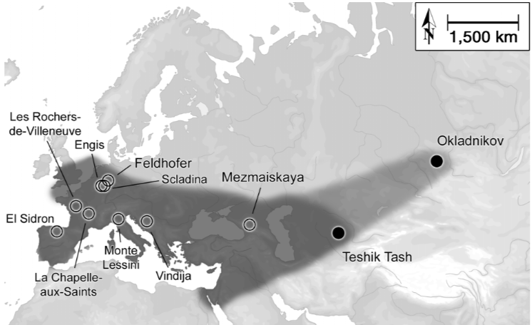
Image 1: The range of neanderthals, including Okladnikov Cave (Krause et al, 2007).
Okladnikov Cave was the first neanderthal site to be discovered in the Altai. The site itself consists of seven stratigraphic layers (named 1-7), with 1-3, 6, and 7 containing cultural remains. While there have been some disturbances, mainly in the upper two layers, the artifacts and faunal and skeletal remains inside the cave (rather than on the terrace area under the roof) were found in situ. The layers were dated to between 44,800±4000 BP (stratum 7, uranium series dating of soil) to 33,500±700 BP (stratum 1, faunal bone, C14 dating) (Krause et al, 2007 supplement). Bones from stratum 3 were radiocarbon dated to between 43,700±1500 to >16,210 BP (Kuzmin, 2004), though the latter date is likely because the roofed terrace was used by animals to avoid inclement weather, rather than from cultural remains. Derevianko is of the opinion that the cultural layers date to 45-40 ka BP (Derevianko et al, 2013).
Okladnikov Cave and Chagyrskaya Cave are the two examples of the Sibiryachikha tool industry. This industry is characterized by primary radial reduction strategies, mass production of flakes coming off cores from multiple angles, scrapers, and déjeté type tools (Derevianko et al, 2013). Lithics are mainly sourced from pebbles from the nearby rivers, which are predominately igneous, though 25.8% of the assemblage at Okladnikov cave is made of Zasuriye jasperoid, which was used selectively (Derevianko et al, 2013, 2015). There is a fairly high ratio of tools to flakes, and preliminary knapping was likely preformed offsite. Core blanks were then brought into the cave to be modified into tools onsite. In addition to radial cores, Levallois reduction strategies are present in relation to many morphological products (Derevianko et al, 2013). Derevianko et al agree that there is one cultural tradition present in the Altai in the Paleolithic, but that within it different tool industries exist. One, the Altai Mousterian, is associated with Denisova Cave and Tyumechin-1, while the other, a Levallois variant, is associated with Kara-Bom, Ust-Karakol-1, Anui-3, Ust-Kanskaya Cave, and possibly others. The Sibiryachikha tool industry from Okladnikov and Chagyrskaya Caves, thus, represents a third (likely very small) Mousterian neanderthal population, who may have moved into the Altai from southwestern Central Asia. Whether these people then assimilated, moved elsewhere, or died out is unclear, since there are no examples of the Sibiryachikha tool industry by the Upper Paleolithic (Derevianko et al, 2013).
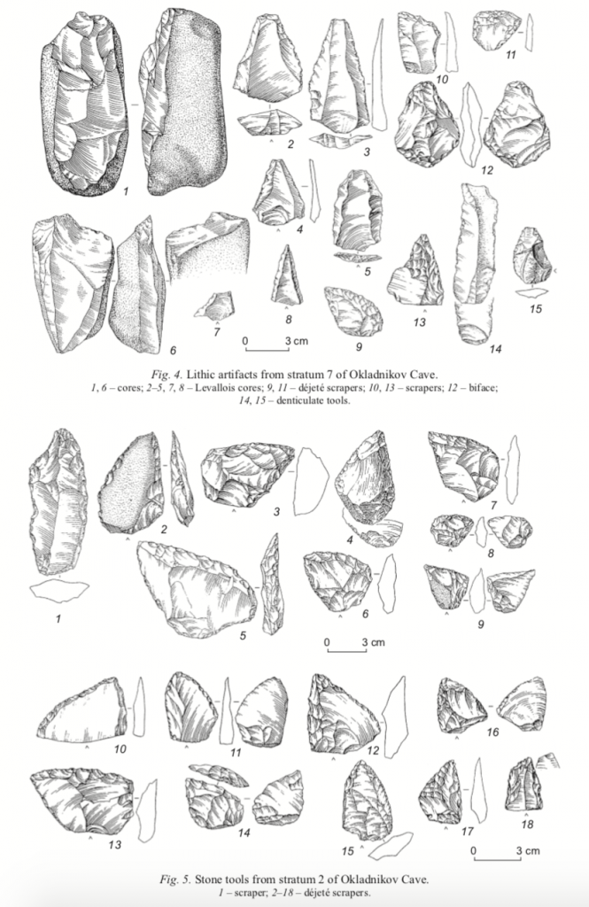
Image 2: Examples of tools from Sibiryachikha tools from Okladnikov Cave (Derevianko et al, 2013).
The human remains found from Okladnikov cave were the first neanderthals found in the Altai. The remains are as follows: adult humerus and human M3 tooth from stratum 2, subadult humerus and femur, adult middle hand phalanx, and three teeth (P3, M1, M3) from stratum 3, and lower dm2 tooth from stratum 7 (Krause et al, 2007 supplement). Krause et al posit that the humerus and femur in stratum 3 are from the same subadult individual. The mtDNA sequence of these individuals clearly shows a gene pool distinct from modern humans, and confirms their neanderthal provenience. Their study compares the mtDMA from European neanderthals with Tekish-Tash and the Okladnikov individuals, which showed that, though Tekish-Tash was more closely related to Western European neanderthals than it was to the Okladnikov individuals, the minimal mtDNA divergence suggested that none of these population had been separated for very long (Krause et al, 2007). Moreover, Dobrovolskaya and Tiunov confirmed that neanderthals at Okladnikov cave had a diet similar to European neanderthals—namely, hunting large herbivores (Dobrobolskaya and Tiunov 2013).
Okladnikov Cave has played a pivotal role in further understanding neanderthal population migrations, pushing their habitation extent 2,000km further east. Subsequent excavation and research have confirmed the existence of a neanderthal population in the Altai, with their associated lithic assemblage. Okladnikov and Chagyrskaya Caves show evidence of an offshoot neanderthal population associated with the Sibiryachikha tool industry, who may have been later arrivals to the region. This site furthers our understanding of the Middle Paleolithic in the Altai and, more broadly, in Central Asia as a whole.
Citations:
Derevianko, A.P., Postnov, A.V., Rybin, E.P., Kuzmin, Y.V., Keates, S.G., 2005. The Pleistocene Peopling of Siberia: A Review of Environmental and Behavioral Aspects. Indo-Pacific Prehistory Association Bulletin. 25 (3) pp. 57-68.
Derevianko, A.P., Markin, S.V., and Shunkov, M.V., 2013. The Sibiryachikha Facies of the Middle Paleolithic of the Altai. Archaeology Ethnography & Anthropology of Eurasia. 41 (1) pp. 89-103.
Derevianko, A.P., Markin, S.V., Kulik, N.A., Kolobova, K.A., 2015. Lithic Raw Material Exploitation in the Sibiryachinkha Facies, The Middle Paleolithic of Altai. Archaeology Ethnography & Anthropology of Eurasia. 43 (3) pp. 3-16.
Dobrobolskaya, M.V., and Tiunov, A.V., 2013. The Neanderthals of Okladnikov Cave, Altai: Environment and Diet Based on Isotopic Analysis. Archaeology Ethnography & Anthropology of Eurasia. 41 (1) pp. 78-88.
Krause, J., Orlando, L., Serre, D., Viola, B., Richards, M.P., Hublin, J.J., Hänni, C., Derevianko, A.P., Pääbo, S., 2007. Neanderthals in Central Asia and Siberia. Nature 448 (18) pp. 902-904.
Kuzmin, Y.V., 2004. Origin of the Upper Paleolithic in Siberia: A Geoarchaeological Perspective. The Early Upper Paleolithic beyond Western Europe. University of California Press, pp. 196-206.
Skoglund, P., Northoff, B.H., Shunkov, M.V., Derevianko, A.P., Pääbo, S., Krause, J., Jakobsson, M., 2014. Separating endogenous ancient DNA from modern day contamination in a Siberian Neandertal. Proceedings of the National Academy of Sciences of the United States of America. 111 (6) pp. 2229-2234.
Viola, B., and Pääbo, S., 2013. What’s New in Central Asia? Basic Issues in Archaeology, Anthropology, and Ethnography of Eurasia. pp. 555-565.
ПЕЩЕРА ИМ. А. П. ОКЛАДНИКОВА. Welcome to Altai. n.d. Web. 7 Dec 2017. <http://welcometoaltai.ru/attractions/peshhera_okladnikova/>
Terekty-Aulie
December 7, 2017
Alternate Spellings:
Terekty-Auliye, Terekty-Aulie, Теректы-Аулие (Cyrillic)
Introduction and Geographic Location:
Coordinates: 48°12’44’’ N and 68°36’37’’ E
Elevation: 498 m
Terekty Aulie is an archaeological site in Central Kazakhstan featuring 3 granite hills with petroglyphs and multiple burial areas dating to the Bronze Age (2nd century BCE), the Early Iron Age and the 18th/19th centuries. The site is located in the district of Ulytau (Ulutau) in the Qaraghandy (Karaganda) region (Lymer 2015: 96). Terekty Aulie is ~90km northeast of the city Jezqazghan (Zhezkazgan) and ~20km north of Terekty Station (Lymer 2015:96, Rogozhinskiy 2011: 31). Using GoogleEarth, I measured the main area of the granite hills to be approximately 17,439 square meters. While the region is located in the heart of the desert steppe, this site is located in the mountainous area of the Terekty Hills, which are within the larger mountain Range known as the Ulytau (Ulutau) Mountains (Lymer 2015: 96). Jezqazghan (Zhezkazgan) is known for its abundance of oxidic copper, which was a prime resource for mining and creation of goods during the Bronze Age (Lymer 2015: 97).
Research on the site has mainly focused on the petroglyphs, which have been attributed to the pastoral nomads living in the area during the Bronze Age. Today, the site is an important religious location because of the petroglyphs and their connection to Islam (Lymer 2014).
Archaeology:
The site was first recorded in the 1940s by Kazakh archaeologist, A. Kh. Margulan (Samashev et al 2000: 4). Between the years of 1946 and 1950, Margulan led many field expeditions throughout the Ulytau area and which was when he first explored and noted Terekty Aulie (Tursinbaeva et al 2016: 172). Unfortunately, not much of this information was published and the original documents are difficult to find online.
In 1996, a program was started to continue research at the site by the A. Kh Margulan Institute of Archaeology led by Zainolla Samashev. (Samashev et al 2000: 4).
Findings and Interpretations:
As mentioned, Terekty Aulie encompasses 3 granite hills, which are engraved with mostly zoomorphic figures. The petroglyphs are mainly carved on the flatter surfaces of the hills, but also occasionally on the more vertical wall-like slopes (Samashev et al 2000:5). Typically rock art from this time period and region is found on sandstone because it is a much softer stone to carve into and makes it easier to create detailed images. Terekty Aulie is a unique example because it was created on granite using a technique of deep pecking and smoothing over, leaving us with the polished final product we see today (Lymer 2015: 96, Samashev et al 2000: 5). As with many petroglyph sites, it is difficult to determine exactly what the site represented or was used for. The site has more recently been adopted as an area for Islamic pilgrimage, which will be discussed below, but it is impossible to say what its exact purpose was at the time of its creation based on the information available.
Images of horses make up approximately 90% of the petroglyphs, but other images include lines, chariots, dots, bulls, Bactrian camels, goats, feline-like creatures, snakes and deer (Lymer 2015: 96-97, Rogozhinskiy 2011: 31). Horse imagery is common in Central Asia because of the important role these animals played in pastoral nomadism. Pastoral nomadism was a dominant lifestyle in Central Asia beginning around the Bronze Age that relied on mobility and herding of animals. Horses provided means of transportation as well as a resource for meat and secondary products (i.e. milk), which made them a prominent aspect of the nomadic lifestyle (Cunliffe 2015). It seems likely that the individuals who created the petroglyphs at Terekty Aulie lived a nomadic lifestyle because of the emphasis on horses in their art (Tursinbaeva et al 2016: 171).
The petroglyphs found at Terekty Aulie have been connected to the Seima Turbino phenomenon based on the similarities in horse image style to other zoomorphic designs in Central Asia. The “solid bodies, curved necks and prominent manes,” on the horses, which make up the majority of petroglyphs at Terekty Aulie, are comparable to images of horses found on daggers from Seima Turbino sites (Samashev et al 2000:5). This phenomenon is attributed to the rise of pastoral nomadism, which influenced the flow of ideas, materials and people on the Central Asian landscape.

Figure 1: Horse petroglyphs at Terekty Aulie
Lymer 2015
Non-horse images, specifically the deer and feline animals, are more similar in style to petroglyphs found in the Altai Mountains, which are considered to be from an early Scythian culture (Samashev et al 2000: 5). Images of humans are uncommon at Terekty Aulie, but the few instances of anthropomorphic figures have generated many varying interpretations. For example, the image below, known as “the antenna”, has a circular design with animals drawn inside the circle and a human with a twisted leg standing beneath it. Some believe that this image is of the sun or another astrological figure, which could be related to a type of “solar symbolism” while others imagine that it represents a human on a shamanistic journey (Samashev et al 2000: 6, Lymer 2015: 99, Tursinbaeva et al 2016: 171). Personally, the shape of the petroglyph reminds me of the desert kites found in Eastern Central Asia and the Middle East which were are dated to the Iron Age. These kites are hypothesized to be hunting traps used to efficiently herd ungulates to a pit humans could easily kill them (Zeder et al 2013: 110, 114). Below is the petroglyph at Terekty Aulie in comparison with petroglyphs of desert kites in Syria (Figure 2, Figure 3).

Figure 2: Image of “the antenna” at Terekty Aulie, possibly depicting a desert kite
Samashev et al 2000

Figure 3: Image of petroglyphs in Syria possibly depicting desert kites
Zeder et al 2013
To the southeast of Terekty Aulie, there is a small cemetery that has been dated to the Bronze Age. The cemetery includes 20 burials that have been attributed to the Alakul culture or the Begazy-Dandybai culture, which are both regional variations within the larger Andronovo culture describing pastoral nomads living in Kazakhstan and Southern Siberia (Lymer 2015: 97, Lymer 2010, Frachetti 2008). The site also includes scattered Neolithic tools, Early Iron Age burials in the style of kurgans and a more recent, 18th/19th century mausoleums (Samashev et al 2000: 4).
In the present day, Terekty Aulie serves as a sacred Islamic shrine because some of the images have been interpreted as being Islamic figures. Currently, a wooden post sits at the top of one of the engrave granite hills, which replaced a stone shrine shown in Figure 4 that had been there until 2001 (Lymer 2014: 3).

Figure 4: Shrine at Terekty Aulie (before 2001), replaced by wood post in 2001
Lymer 2014
Terekty Aulie is a place of pilgrimage because it is believed to hold healing properties that can help situations of sickness or infertility (Lymer 2010). This belief comes from the story of Khazrat ‘Ali, the son-in-law of the prophet Muhammad, visiting Terekty Aulie with his horse, Dudul. Khazrat ‘Ali was wounded when he arrived to the site and fell asleep on the rocky hills expecting to die. Instead, when he awoke he found that at all his wounds had been healed (Tursinbaeva et al 2016: 171). In the rock art are images of human footprints and horse hoof prints, which are thought to belong to Khazrat ‘Ali and his horse (Figure 5, Figure 6) (Lymer 2014: 4).

Figure 6: Image of human foot print petrogylphs at Terekty Aulie
Lymer 2004

Figure 7: Image of horse hoof print petroglyph at Terekty Aulie
Lymer 2004
At the base of one of the hills are 18th/19th century mausoleums, which have more recently been fenced in and expanded with the addition of modern mausoleums. Individuals make the pilgrimage to Terekty Aulie, not only for its healing properties and connection to Islam, but also to pay homage to the people buried in the mausoleums. Individuals often hold ritual meals near the base of the hill, which are rooted in prayer, specific meal preparation and memorial offerings (Lymer 2010, Lymer 2014: 4).
Dating:
The site has been dated to the Bronze Age (approximately during the 2nd century BCE) using contextual clues. Since the petroglyphs are carved into rocks, they are impossible to date using typical scientific measures such as carbon dating or electron spin resonance dating. The archaeologists researching this site instead used methods of comparison and inference to come up with an approximate date but these are not scientifically proven dates.
The cemetery southeast of Terekty Aulie was dated to the Bronze Age based on its materials. However, there is no conclusive link between the cemetery and the petroglyphs to prove that these two sites were created at the same time or by the same group of people (Lymer 2015: 97). Unfortunately, there is little information published about this cemetery and the materials recovered from it. The knowledge that Jezqazghan was a city known for copper resources during the Bronze Age makes it more likely that Terekty Aulie was used during the same period, but again it is impossible to make definite conclusions about when the petroglyphs were created (Lymer 2015: 97).
A secondary method of dating used at the site was a comparison technique to examine the similarities and differences between this site and other sites in the area with more certain dates. As mentioned previously, the style of the horse petroglyphs are similar to designs from Seima Turbino sites, which are dated between 2200–1700 BCE (Lymer 2015: 97).
Conclusion:
While the petroglyphs at Terekty Aulie produce archaeological difficulties with regards to dating and deciphering the original purpose of the site, the site also provides an amazing opportunity to understand how the area has changed over time. The remains from multiple time periods, the unique material of rock and the connection to Islam continues to attract a variety of people. From tourists to researchers to individuals on religious journeys, Terekty Aulie is an important site to many.
To check out a 3D interactive model of the site created by Kenneth Lymer, please see the link below!
https://sketchfab.com/models/7e0ca19553d1402e8420c640dabe4ca0
Works Cited
Cunliffe, Barry. “Horses and Copper.” Steppe, Desert and Ocean. Oxford: Oxford University Press, 2015. 71-109.
Frachetti, Michael D. “An archaeology of Bronze Age Eurasia.” Pastoralist Landscapes and Social Interaction in Bronze Age Eurasia. Los Angeles: University of California Press, 2008. 31-71.
Lymer, Kenneth. “Rock Art and Folk Islamic Practices in Central Asia.” Encyclopaedia of the History of Science, Technology, and Medicine in Non-Western Cultures. Springer Science & Business Media, 2014.
Lymer, Kenneth. “Rock Art and Religion: The Percolation of Landscapes and Permeability of Boundaries at Petroglyph Sites in Kazahkstan.” DISKUS. 11 (2010).
Lymer, Kenneth. “The Petroglyphs of Terekty Aulie in Central Kazakhstan.” Expression. 8 (2015).
Rogozhinskiy, Alexey E. “Rock Art Sites in Kazakhstan.” Rock Art in Central Asia. Ed. Jean Clottes. Paris: International Council on Monuments and Sites, 2011. 9-43.
Samashev, Zainolla, et al. “The Petroglyphs of Terekty Aulie, Central Kazahkstan.” International Newsletter on Rock Art. 5 (2000).
Tursinbaeva, K. S., et al. “Petroglyphs Terekty-Aulie in Central Kazahkstan.” Eurasian Journal of Ecology. 38.2 (2016).
Zeder, Melinda A., et al. “New perspectives on the use of kites in mass-kills of Levantine gazelle: A view from northeastern Syria.” Quarternary Internation. 297 (2013).
Kulbulak
December 7, 2017
By Jack Leddy
Alternative Spelling: Kul’Bulak
Coordinates: 41°00′31′′N, 70°00′22′′E (Flas, 2010)
Elevation: 1044m asl
Geography: Kulbulak is an open-air Paleolithic site in the Tashkent region of Uzbekistan, lying at the base of the Chatkal range of the Tian Shan mountains. The Tashkent region is in the northeast of Uzbekistan and contains its capital, also named Tashkent. Kulbulak is not particularly remote, as it is only a few kilometers from the town of Angren (Flas, 2010). Kulbulak was also a prime location for prehistoric inhabitation, having all the resources necessary for their way of life, including a nearby source of flint at Kyzyl-Alma, evidently used to make much of the tool assemblage at Kulbulak. Additionally, Kulbulak is close to the Dzhar-sai and the Kyzylalma rivers (Vandenberghe, 2014), along with several smaller brooks and streams which would have provided a source of drinkable water to Paleolithic peoples.
Excavation and Dating: Kulbulak was first discovered in 1962 by M.R. Kasymov, and has been excavated several times since. To date, the total area that has been excavated is about 600 square meters (Flas, 2010). In this area, close to 70,000 artifacts have been recovered (Vandenberghe, 2014). Much like many other open-air Central Asian sites, the dating at Kulbulak is quite complicated, especially due to the remarkably complex stratigraphy. The excavated artifacts were initially relatively dated, as the bladelets found are quite similar to those at another Uzbek site, Dodekatym 2, which has been dated to about 23ka (Flas, 2010). More recent attempts, however, employed luminescence dating, a method which examines when sediments were exposed to light, revealing when they were deposited. The dating resulted in a range of about 39ka to about 82ka. This suggests an Upper Paleolithic origin of more recent layers, and a Middle Paleolithic origin of the deeper ones.
Lithic Analysis: As indicated by the luminescence dating, the tool assemblage of the site has been separated into two main categories loosely based on their stratigraphic layers, representing the technology of either the Middle or Upper Paleolithic. Kasymov originally thought there was a third layer, consisting of Lower Paleolithic Acheulian tools, but there is no evidence to support his hypothesis (Dani, 1999). The entire tool assemblage at Kulbulak is overwhelmingly flint-based, with a few instances of limestone, diorite, and quartzite (Vishnyatsky, 1999). The Upper Paleolithic tool-kit consists of cores, bladelets, and debitage, as is to be expected of an Upper Paleolithic assemblage in this region, but the stratigraphic layers also contain several tools indicative of a Middle Paleolithic core and flake industry.

A sample of the tool assemblage at Kulbulak, image from (Flas, 2010)
Another interesting anomaly of the Kulbulak artifacts is the presence of several “Pseudo-tools” (Vandenberghe, 2014). These pseudo-tools take the shape of denticulate blades, but they have been discounted by some as having been made naturally by alluvial processes rather than deliberately by humans. This is supported by the fact that much of the sediment where the tools were excavated is attributed to flood deposits from the nearby rivers (Vandenberghe, 2014). Kulbulak is also made distinct by the presence of bifacial Middle Paleolithic hand-axes. These bifaces, shaped into leaf-shaped points, differentiate Kulbulak from nearby sites, as it is the only site at which such tools are found. In fact, there are no other bifaces at all in the general area. Most of the other sites were limited to core and flake industries in the Middle Paleolithic.
Anthropological Analysis: Unfortunately, due to a lack of organic material found at Kulbulak (with the exception of a single human molar and a few assorted animal bones), any understanding of human activity must rely on mostly conjecture. Furthermore, the complex stratigraphy makes it difficult to make assumptions about the technological progression of Kulbulak’s inhabitants, but it lends credence to another theory regarding the cultures of the area. Analysis of multiple nearby sites has resulted in the idea of a ‘Kulbulakian’ culture existing throughout the region (Kolobova, 2014). The Middle to Upper Paleolithic tool assemblage indicates that this culture was present for a long period of time, as was the site itself, though perhaps intermittently. Despite the nomadic tendencies of Upper Paleolithic Central Asian people, the allure of a source of abundant flint could have convinced the Kulbulakians to maintain a more sedentary community than most of their contemporaries.

Single human molar found at Kulbulak, image from (Flas, 2010)
The site’s proximity to water also makes Kulbulak a prime location for a settlement, but despite these facts, there have been no hearths or fire pits discovered (Vishnyatsky, 1999). This of course does not mean that hearths and fire pits did not ever exist there, but it contributes to the enigmatic nature of the site. Another discovery pertinent to anthropological analysis of Kulbulak is the Kyzyl-Alma site. Kyzyl-Alma is only about one kilometer away from Kulbulak, and the two sites seem to have been home to one group of people (Kolobova, 2014). The first piece of evidence for this hypothesis is that the tool assemblages of the two sites are remarkably similar. The second, and more compelling, piece of evidence is the proximity of Kyzyl-Alma to flint outcroppings (Kolobova, 2014). This is relevant because of the overwhelming number of flint tools unearthed at Kulbulak. It is likely that Kyzyl-Alma served as an excavating point for the raw material. Due to the fully formed tools found there (Kolobova, 2014), it can be inferred that the crafting of the tools took place at this site as well. The completed tools would then have been transported to Kulbulak. This hypothesis can be corroborated by the lack of cores in recent stratigraphic layers at Kulbulak, meaning they probably were not making new tools there (Kolobova, 2014).
As is the case with many Central Asian sites, the anthropological implications of Kulbulak remain clouded by uncooperative stratigraphy and lack of reliably datable artifacts, but through inference and examination of available data it is possible to form a vague picture of the lives of the Kulbulakians.
Sources
Dani, Ahmad Hasan., Masson, V.M., Harmatta, J., Litvinovski, B.A., Bosworth, C.E. History of
Civilizations of Central Asia. Vol. 1, Motilal Banarsidass Publishers, 1999.
Flas, D., Kolobova, K., Pavlenok, K., Vandenberghe, D., De Dapper, M., Leschinsky, S., Bence,
V., Islamov, U., Derevianko, A., Cauwe, N., 2010. Preliminary results of new excavations at the Palaeolithic site of Kulbulak (Uzbekistan). Antiquity. 325.
Kolobova, K.A., Krivoshapin, A.I., 2014. Кульбалбекская культура в контексте
ауриньякского языка в Азии. Publishing Department of the Institute of Archaeology and Ethnography.
Vandenberghe, D.A.G., Flas, D., De Dapper, M., Van Nieuland, J., Kolobova, K., Pavlenok, K.,
Islamov, U., De Pelsmaeker, E., Debeer, A.E., Buylaert, J.P., 2014. Revisiting the Palaeolithic site of Kulbulak (Uzbekistan): First results from luminescence dating. Quaternary International. 324, 180-189.
Vishnyatsky, Leonid, 1999. The Paleolithic of Central Asia. Journal of World Prehistory. 13, 28-
42.